
Chin J Plant Ecol ›› 2022, Vol. 46 ›› Issue (10): 1305-1316.DOI: 10.17521/cjpe.2022.0158 cstr: 32100.14.cjpe.2022.0158
Special Issue: 全球变化与生态系统; 生态遥感及应用
• Research Articles • Previous Articles
LIU Bing-Bing1,2, WEI Jian-Xin1,2,3,*( ), HU Tian-Yu4,5, YANG Qiu-Li4,5, LIU Xiao-Qiang4,5, WU Fa-Yun6, SU Yan-Jun4,5, GUO Qing-Hua7
Received:2022-04-24
Accepted:2022-09-05
Online:2022-10-20
Published:2022-09-28
Contact:
WEI Jian-Xin
Supported by:LIU Bing-Bing, WEI Jian-Xin, HU Tian-Yu, YANG Qiu-Li, LIU Xiao-Qiang, WU Fa-Yun, SU Yan-Jun, GUO Qing-Hua. Validation and uncertainty analysis of satellite remote sensing products for monitoring China’s forest ecosystems—Based on massive UAV LiDAR data[J]. Chin J Plant Ecol, 2022, 46(10): 1305-1316.
Add to citation manager EndNote|Ris|BibTeX
URL: https://www.plant-ecology.com/EN/10.17521/cjpe.2022.0158
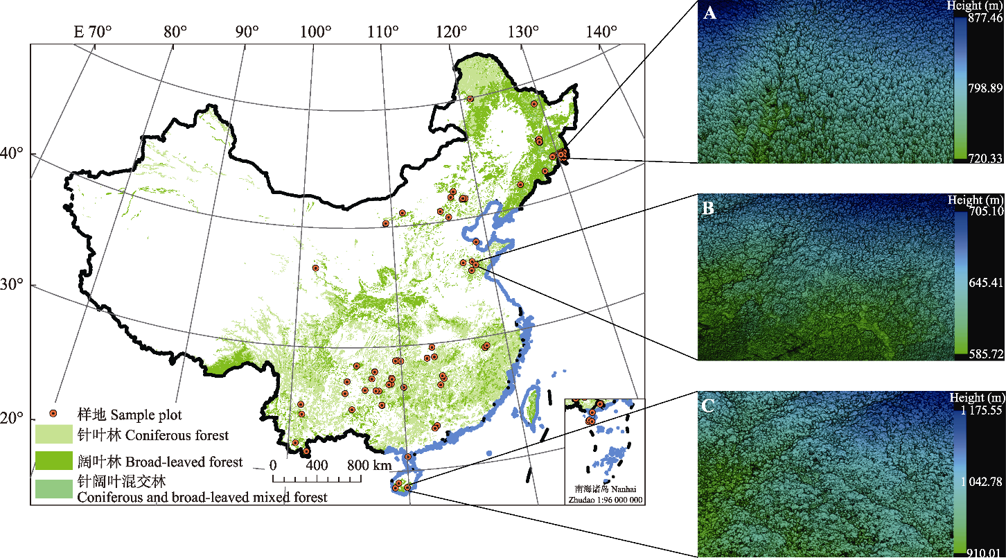
Fig. 1 Spatial distribution of unmanned aerial vehicle (UAV) LiDAR data used in this study, and examples of 3D point cloud rendered by elevation. A, Tazigou Forest Farm, Jilin Province. B, Tianma Forest Farm, Shandong Province. C, Diaoluo Mountain National Forest Park, Hainan Province.
| 无人机 激光雷 达系统 UAV LiDAR system | 激光 传感器 Laser sensor | 最大扫描 频率 Maximum scanning frequency (kHz) | 测量精度 Measurement accuracy (mm) | 视场角 Field of view | 回波次数 Number of returns |
|---|---|---|---|---|---|
| LiAir 220 | HESAI Pandar40 | 720 | ±20 | 360° | 2次 Dual returns |
| LiAir Pro | Riegl VUX-1 | 550 | ±10 | 360° | 多次 Multi-returns |
Table 1 Parameters of unmanned aerial vehicle (UAV) LiDAR system
| 无人机 激光雷 达系统 UAV LiDAR system | 激光 传感器 Laser sensor | 最大扫描 频率 Maximum scanning frequency (kHz) | 测量精度 Measurement accuracy (mm) | 视场角 Field of view | 回波次数 Number of returns |
|---|---|---|---|---|---|
| LiAir 220 | HESAI Pandar40 | 720 | ±20 | 360° | 2次 Dual returns |
| LiAir Pro | Riegl VUX-1 | 550 | ±10 | 360° | 多次 Multi-returns |
| 产品 Product | 版本 Version | 覆盖范围 Spatial coverage | 覆盖时段 Time period | 时空分辨率 Spatiotemporal resolution | 坐标系统及投影基准 Coordinate system and projection datum | 数据来源 Data source |
|---|---|---|---|---|---|---|
| GLASS LAI | V50 | 全球 Global | 2017 | 8 d, 500 m | 正弦投影 Sinusoidal projection | |
| GLCF TCC | V4 | 全球 Global | 2015 | 1 a, 30 m | UTM投影 UTM projection | |
| GFCH | - | 全球 Global | 2019 | 1 a, 30 m | UTM投影 UTM projection | |
Table 2 Basic information of satellite remote sensing products
| 产品 Product | 版本 Version | 覆盖范围 Spatial coverage | 覆盖时段 Time period | 时空分辨率 Spatiotemporal resolution | 坐标系统及投影基准 Coordinate system and projection datum | 数据来源 Data source |
|---|---|---|---|---|---|---|
| GLASS LAI | V50 | 全球 Global | 2017 | 8 d, 500 m | 正弦投影 Sinusoidal projection | |
| GLCF TCC | V4 | 全球 Global | 2015 | 1 a, 30 m | UTM投影 UTM projection | |
| GFCH | - | 全球 Global | 2019 | 1 a, 30 m | UTM投影 UTM projection | |
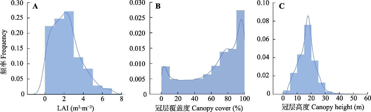
Fig. 2 Histograms of three forest structural attributes derived from unmanned aerial vehicle (UAV) LiDAR data. LAI, leaf area index.
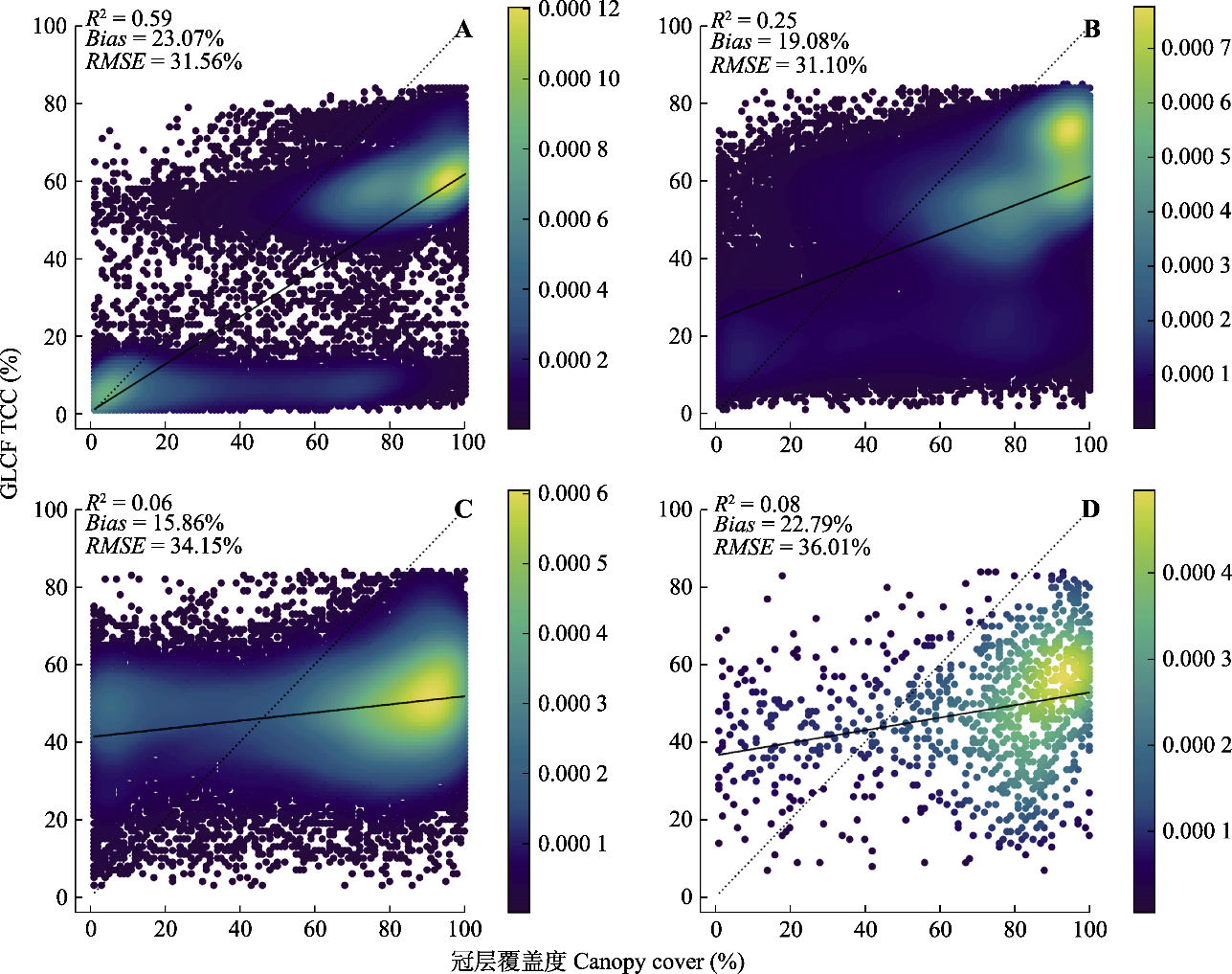
Fig. 3 Scatter plots of canopy cover estimated from unmanned aerial vehicle (UAV) LiDAR data and Global Land Cover Facility-Tree Canopy Cover (GLCF TCC) under different uncertainty levels provided by GLCL TCC. The dotted lines are 1:1 lines, the solid lines are fitted lines, and color bars represent the probability density of observations with dark blue for low density and yellow for high density. A, Uncertainty: 0-5%. B, Uncertainty: 5%-10%. C, Uncertainty: 10%-15%. D, Uncertainty: above 15%. R2, determinant coefficient; RMSE, root mean square error.
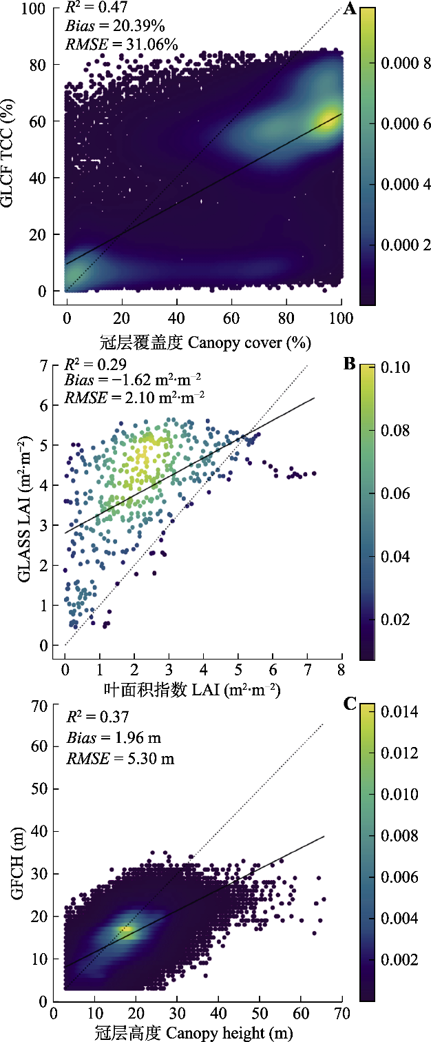
Fig. 4 Accuracy of three satellite remote sensing products against unmanned aerial vehicle (UAV) LiDAR observations. The dotted line is the 1:1 line, the solid line is the fitted line, and the color bar represents the probability density of observations. GFCH, Global Forest Canopy Height; GLASS LAI, Global Land Surface Satellite Products System-Leaf Area Index; GLCF TCC, Global Land Cover Facility-Tree Canopy Cover.
| 产品 Product | 林型 Forest type | 坡度 Slope (°) | 冠层覆盖度 Canopy cover (%) | |||||||||
|---|---|---|---|---|---|---|---|---|---|---|---|---|
| a | b | c | 0-10 | 10-20 | 20-30 | ≥30 | 0-30 | 30-60 | 60-80 | ≥80 | ||
| GLCF TCC | R2 | 0.64 | 0.29 | 0.60 | 0.39 | 0.54 | 0.48 | 0.52 | 0.10 | 0.03 | 0.02 | 0.05 |
| Bias (%) | 18.13 | 19.96 | 21.37 | 22.81 | 21.72 | 19.54 | 14.49 | -4.78 | 11.55 | 25.39 | 33.35 | |
| RMSE (%) | 28.40 | 34.16 | 29.45 | 31.70 | 31.17 | 31.63 | 28.69 | 17.02 | 25.72 | 32.57 | 36.87 | |
| 像元数量 N | 15 584 | 37 167 | 51 969 | 39 301 | 23 792 | 23 441 | 18 186 | 21 231 | 16 446 | 23 837 | 43 206 | |
| GLASS LAI | R2 | 0.73 | 0.15 | 0.36 | 0.29 | 0.38 | 0.28 | 0.34 | 0.17 | 0.3 | 0.04 | 0.11 |
| Bias (m2·m-2) | -1.46 | -1.39 | -1.86 | -1.81 | -1.98 | -1.63 | -0.72 | -1.22 | -1.68 | -2.05 | -1.45 | |
| RMSE (m2·m-2) | 1.76 | 2.01 | 2.23 | 2.16 | 2.30 | 2.11 | 1.62 | 1.44 | 2.12 | 2.35 | 2.03 | |
| 像元数量 N | 52 | 196 | 204 | 136 | 87 | 162 | 67 | 24 | 64 | 112 | 252 | |
| GFCH | R2 | 0.35 | 0.40 | 0.34 | 0.45 | 0.37 | 0.31 | 0.37 | 0.09 | 0.14 | 0.27 | 0.25 |
| Bias (m) | 0.64 | 2.87 | 1.23 | 1.67 | 0.79 | 2.09 | 3.22 | -1.73 | 0.20 | 1.36 | 2.72 | |
| RMSE (m) | 3.91 | 6.29 | 4.22 | 4.10 | 4.40 | 5.84 | 6.72 | 5.16 | 4.83 | 4.40 | 5.61 | |
| 像元数量 N | 16 794 | 85 571 | 74 047 | 58 565 | 34 454 | 41 776 | 41 617 | 9 291 | 19 420 | 32 156 | 115 545 | |
Table 3 Influences of different factors on the accuracy of three satellite remote sensing products
| 产品 Product | 林型 Forest type | 坡度 Slope (°) | 冠层覆盖度 Canopy cover (%) | |||||||||
|---|---|---|---|---|---|---|---|---|---|---|---|---|
| a | b | c | 0-10 | 10-20 | 20-30 | ≥30 | 0-30 | 30-60 | 60-80 | ≥80 | ||
| GLCF TCC | R2 | 0.64 | 0.29 | 0.60 | 0.39 | 0.54 | 0.48 | 0.52 | 0.10 | 0.03 | 0.02 | 0.05 |
| Bias (%) | 18.13 | 19.96 | 21.37 | 22.81 | 21.72 | 19.54 | 14.49 | -4.78 | 11.55 | 25.39 | 33.35 | |
| RMSE (%) | 28.40 | 34.16 | 29.45 | 31.70 | 31.17 | 31.63 | 28.69 | 17.02 | 25.72 | 32.57 | 36.87 | |
| 像元数量 N | 15 584 | 37 167 | 51 969 | 39 301 | 23 792 | 23 441 | 18 186 | 21 231 | 16 446 | 23 837 | 43 206 | |
| GLASS LAI | R2 | 0.73 | 0.15 | 0.36 | 0.29 | 0.38 | 0.28 | 0.34 | 0.17 | 0.3 | 0.04 | 0.11 |
| Bias (m2·m-2) | -1.46 | -1.39 | -1.86 | -1.81 | -1.98 | -1.63 | -0.72 | -1.22 | -1.68 | -2.05 | -1.45 | |
| RMSE (m2·m-2) | 1.76 | 2.01 | 2.23 | 2.16 | 2.30 | 2.11 | 1.62 | 1.44 | 2.12 | 2.35 | 2.03 | |
| 像元数量 N | 52 | 196 | 204 | 136 | 87 | 162 | 67 | 24 | 64 | 112 | 252 | |
| GFCH | R2 | 0.35 | 0.40 | 0.34 | 0.45 | 0.37 | 0.31 | 0.37 | 0.09 | 0.14 | 0.27 | 0.25 |
| Bias (m) | 0.64 | 2.87 | 1.23 | 1.67 | 0.79 | 2.09 | 3.22 | -1.73 | 0.20 | 1.36 | 2.72 | |
| RMSE (m) | 3.91 | 6.29 | 4.22 | 4.10 | 4.40 | 5.84 | 6.72 | 5.16 | 4.83 | 4.40 | 5.61 | |
| 像元数量 N | 16 794 | 85 571 | 74 047 | 58 565 | 34 454 | 41 776 | 41 617 | 9 291 | 19 420 | 32 156 | 115 545 | |
| [1] |
Amarnath G, Babar S, Murthy MSR. (2017). Evaluating MODIS- vegetation continuous field products to assess tree cover change and forest fragmentation in India—A multi-scale satellite remote sensing approach. The Egyptian Journal of Remote Sensing and Space Science, 20, 157-168.
DOI URL |
| [2] |
Baret F, Morissette JT, Fernandes RA, Champeaux JL, Myneni RB, Chen J, Plummer S, Weiss M, Bacour C, Garrigues S, Nickeson JE. (2006). Evaluation of the representativeness of networks of sites for the global validation and intercomparison of land biophysical products: proposition of the CEOS-BELMANIP. IEEE Transactions on Geoscience and Remote Sensing, 44, 1794-1803.
DOI URL |
| [3] |
Cai SS, Zhang WM, Jin SN, Shao J, Li LY, Yu SS, Yan GJ. (2021). Improving the estimation of canopy cover from UAV-LiDAR data using a pit-free CHM-based method. International Journal of Digital Earth, 14, 1477-1492.
DOI URL |
| [4] |
Chen C, Park T, Wang XH, Piao SL, Xu BD, Chaturvedi RK, Fuchs R, Brovkin V, Ciais P, Fensholt R, Tømmervik H, Bala G, Zhu ZC, Nemani RR, Myneni RB. (2019). China and India lead in greening of the world through land-use management. Nature Sustainability, 2, 122-129.
DOI PMID |
| [5] | Fang HL. (2020). Development and validation of satellite leaf area index (LAI) products in China. Remote Sensing Technology and Application, 35, 990-1003. |
| [方红亮 (2020). 我国叶面积指数卫星遥感产品生产及验证. 遥感技术与应用, 35, 990-1003.] | |
| [6] |
Gao F, Masek JG, Wolfe RE, Huang CQ. (2010). Building a consistent medium resolution satellite data set using moderate resolution imaging spectroradiometer products as reference. Journal of Applied Remote Sensing, 4, 043526. DOI: 10.1117/1.3430002.
DOI |
| [7] |
García-Haro FJ, Camacho F, Martínez B, Campos-Taberner M, Fuster B, Sánchez-Zapero J, Gilabert MA. (2019). Climate data records of vegetation variables from geostationary SEVIRI/MSG data: products, algorithms and applications. Remote Sensing, 11, 2103. DOI: 10.3390/rs11182103.
DOI |
| [8] |
Gonsamo A, Chen JM. (2011). Evaluation of the GLC2000 and NALC2005 land cover products for LAI retrieval over Canada. Canadian Journal of Remote Sensing, 37, 302-313.
DOI URL |
| [9] | Guo QH, Su YJ, Hu TY, Liu J. (2018). LiDAR Principles, Processing and Applications in Forest Ecology. Higher Education Press, Beijing. |
| [郭庆华, 苏艳军, 胡天宇, 刘瑾 (2018). 激光雷达森林生态应用——理论、方法及实例. 高等教育出版社, 北京.] | |
| [10] |
Hilker T, Wulder MA, Coops NC, Seitz N, White JC, Gao F, Masek JG, Stenhouse G. (2009). Generation of dense time series synthetic Landsat data through data blending with MODIS using a spatial and temporal adaptive reflectance fusion model. Remote Sensing of Environment, 113, 1988-1999.
DOI URL |
| [11] |
Hu TY, Sun XL, Su YJ, Guan HC, Sun QH, Kelly M, Guo QH. (2020a). Development and performance evaluation of a very low-cost UAV-Lidar system for forestry applications. Remote Sensing, 13, 77. DOI: 10.3390/rs13010077.
DOI |
| [12] |
Hu TY, Zhang YY, Su YJ, Zheng Y, Lin GH, Guo QH. (2020b). Mapping the global mangrove forest aboveground biomass using multisource remote sensing data. Remote Sensing, 12, 1690. DOI: 10.3390/rs12101690.
DOI |
| [13] |
Jakubowski MK, Guo QH, Kelly M. (2013). Tradeoffs between lidar pulse density and forest measurement accuracy. Remote Sensing of Environment, 130, 245-253.
DOI URL |
| [14] |
Jin HA, Li AN, Bian JH, Nan X, Zhao W, Zhang ZJ, Yin GF. (2017). Intercomparison and validation of MODIS and GLASS leaf area index (LAI) products over mountain areas: a case study in southwestern China. International Journal of Applied Earth Observation and Geoinformation, 55, 52-67.
DOI URL |
| [15] | Li WJ, Zhao CY, Bie Q, Gao CC, Gao YF. (2015). Retrieval of the forest structural parameters using airborne LiDAR data. Remote Sensing Technology and Application, 30, 917-924. |
| [李文娟, 赵传燕, 别强, 高婵婵, 高云飞 (2015). 基于机载激光雷达数据的森林结构参数反演. 遥感技术与应用, 30, 917-924.] | |
| [16] |
Li XL, Lu H, Yu L, Yang K. (2018). Comparison of the spatial characteristics of four remotely sensed leaf area index products over China: direct validation and relative uncertainties. Remote Sensing, 10, 148. DOI: 10.3390/rs10010148.
DOI |
| [17] | Li ZY, Liu QW, Pang Y. (2016). Review on forest parameters inversion using LiDAR. Journal of Remote Sensing, 20, 1138-1150. |
| [李增元, 刘清旺, 庞勇 (2016). 激光雷达森林参数反演研究进展. 遥感学报, 20, 1138-1150.] | |
| [18] | Lin XJ. (2021). Remote Sensing Diagnosis of Forest Canopy Height and Forest Aboveground Biomass Based on ICESat-2 and GEDI. Master degree dissertation, Aerospace Information Research Institute, Chinese Academy of Sciences, Beijing. |
| [林晓娟 (2021). 基于ICESat-2和GEDI森林冠层高度和森林地上生物量遥感诊断. 硕士学位论文, 中国科学院空天信息创新研究所, 北京.] | |
| [19] |
Liu XQ, Su YJ, Hu TY, Yang QL, Liu BB, Deng YF, Tang H, Tang ZY, Fang JY, Guo QH. (2022). Neural network guided interpolation for mapping canopy height of Chinaʼs forests by integrating GEDI and ICESat-2 data. Remote Sensing of Environment, 269, 112844. DOI: 10.1016/j.rse.2021.112844.
DOI |
| [20] |
Ma Q, Su YJ, Guo QH. (2017). Comparison of canopy cover estimations from airborne LiDAR, aerial imagery, and satellite imagery. IEEE Journal of Selected Topics in Applied Earth Observations and Remote Sensing, 10, 4225-4236.
DOI URL |
| [21] |
Montesano PM, Neigh CSR, Sexton J, Feng M, Channan S, Ranson KJ, Townshend JR. (2016). Calibration and validation of landsat tree cover in the Taiga-Tundra ecotone. Remote Sensing, 8, 551. DOI: 10.3390/rs8070551.
DOI |
| [22] |
Pan YD, Birdsey RA, Fang JY, Houghton R, Kauppi PE, Kurz WA, Phillips OL, Shvidenko A, Lewis SL, Canadell JG, Ciais P, Jackson RB, Pacala SW, McGuire AD, Piao SL, et al. (2011). A large and persistent carbon sink in the world’s forests. Science, 333, 988-993.
DOI URL |
| [23] |
Potapov P, Li X, Hernandez-Serna A, Tyukavina A, Hansen MC, Kommareddy A, Pickens A, Turubanova S, Tang H, Silva CE, Armston J, Dubayah R, Blair JB, Hofton M. (2021). Mapping global forest canopy height through integration of GEDI and Landsat data. Remote Sensing of Environment, 253, 112165. DOI: 10.1016/j.rse.2020.112165.
DOI |
| [24] |
Richardson JJ, Moskal LM, Kim SH. (2009). Modeling approaches to estimate effective leaf area index from aerial discrete- return LiDAR. Agricultural and Forest Meteorology, 149, 1152-1160.
DOI URL |
| [25] |
Roujean JL, Lacaze R. (2002). Global mapping of vegetation parameters from POLDER multiangular measurements for studies of surface-atmosphere interactions: a pragmatic method and its validation. Journal of Geophysical Research, 107, 4150. DOI: 10.1029/2001JD000751.
DOI |
| [26] |
Schleppi P, Thimonier A, Walthert L. (2011). Estimating leaf area index of mature temperate forests using regressions on site and vegetation data. Forest Ecology and Management, 261, 601-610.
DOI URL |
| [27] |
Sexton JO, Song XP, Feng M, Noojipady P, Anand A, Huang C, Kim DH, Collins KM, Channan S, DiMiceli C, Townshend JR. (2013). Global, 30-m resolution continuous fields of tree cover: landsat-based rescaling of MODIS vegetation continuous fields with lidar-based estimates of error. International Journal of Digital Earth, 6, 427-448.
DOI URL |
| [28] | Song HL, Zhang XN, Wang Y, Wang M. (2012). Comparison of relative uniformity between GLOBCOVER and MODIS land cover data sets. Transactions of the Chinese Society of Agricultural Engineering, 28(15), 118-124. |
| [宋宏利, 张晓楠, 王雨, 王萌 (2012). 多尺度高分辨率全球土地覆被遥感产品相对一致性比较. 农业工程学报, 28(15), 118-124.] | |
| [29] |
Su YJ, Ma Q, Guo QH. (2017). Fine-resolution forest tree height estimation across the Sierra Nevada through the integration of spaceborne LiDAR, airborne LiDAR, and optical imagery. International Journal of Digital Earth, 10, 307-323.
DOI URL |
| [30] |
Tang H, Song XP, Zhao FA, Strahler AH, Schaaf CL, Goetz S, Huang CQ, Hansen MC, Dubayah R. (2019). Definition and measurement of tree cover: a comparative analysis of field-, lidar- and landsat-based tree cover estimations in the Sierra national forests, USA. Agricultural and Forest Meteorology, 268, 258-268.
DOI |
| [31] |
Valderrama-Landeros LH, España-Boquera ML, Baret F. (2016). Deforestation in Michoacan, Mexico, from CYCLOPES- LAI time series (2000-2006). IEEE Journal of Selected Topics in Applied Earth Observations and Remote Sensing, 9, 5398-5405.
DOI URL |
| [32] | Wu XD, Xiao Q, Wen JG, Liu Q, Peng JJ, Li XW. (2014). Advances in uncertainty analysis for the validation of remote sensing products: take leaf area index for example. Journal of Remote Sensing, 18, 1011-1023. |
| [吴小丹, 肖青, 闻建光, 刘强, 彭菁菁, 李小文 (2014). 遥感数据产品真实性检验不确定性分析研究进展. 遥感学报, 18, 1011-1023.] | |
| [33] | Xia WT, Wang Y, Feng QS, Liang TG. (2010). Accuracy assessment of MODIS land cover product of Gannan Prefecture. Pratacultural Science, 27(9), 11-18. |
| [夏文韬, 王莺, 冯琦胜, 梁天刚 (2010). 甘南地区MODIS土地覆盖产品精度评价. 草业科学, 27(9), 11-18.] | |
| [34] | Xiang Y, Xiao ZQ, Liang SL, Wang JD, Song JL. (2014). Validation of global land surface satellite (GLASS) leaf area index product. Journal of Remote Sensing, 18, 573-596. |
| [向阳, 肖志强, 梁顺林, 王锦地, 宋金玲 (2014). GLASS叶面积指数产品验证. 遥感学报, 18, 573-596.] | |
| [35] |
Xiao ZQ, Liang SL, Wang JD, Chen P, Yin XJ, Zhang LQ, Song JL. (2014). Use of general regression neural networks for generating the GLASS leaf area index product from time-series MODIS surface reflectance. IEEE Transactions on Geoscience and Remote Sensing, 52, 209-223.
DOI URL |
| [36] | You HT, Xing YQ, Wang Z, Sun XT, Wang M. (2014). Estimation of the leaf area index of coniferous forests using LiDAR discrete point cloud. Journal of Northwest Forestry University, 29(3), 41-47. |
| [尤号田, 邢艳秋, 王铮, 孙小添, 王萌 (2014). 利用LiDAR离散点云估测针叶林叶面积指数. 西北林学院学报, 29(3), 41-47.] | |
| [37] |
Zhao XQ, Guo QH, Su YJ, Xue BL. (2016). Improved progressive TIN densification filtering algorithm for airborne LiDAR data in forested areas. ISPRS Journal of Photogrammetry and Remote Sensing, 117, 79-91.
DOI URL |
| Viewed | ||||||
|
Full text |
|
|||||
|
Abstract |
|
|||||
Copyright © 2026 Chinese Journal of Plant Ecology
Tel: 010-62836134, 62836138, E-mail: apes@ibcas.ac.cn, cjpe@ibcas.ac.cn
![]()