
Chin J Plant Ecol ›› 2010, Vol. 34 ›› Issue (7): 800-810.DOI: 10.3773/j.issn.1005-264x.2010.07.005
• Research Articles • Previous Articles Next Articles
TANG Li-Xia1,3,*( ), ZHANG Zhi-Qiang1,**(), WANG Xin-Jie2, WANG Sheng-Ping4, ZHA Tong-Gang1
Received:2009-10-13
Accepted:2010-03-01
Online:2010-10-13
Published:2010-07-01
Contact:
ZHANG Zhi-Qiang
TANG Li-Xia, ZHANG Zhi-Qiang, WANG Xin-Jie, WANG Sheng-Ping, ZHA Tong-Gang. Streamflow response to climate and landuse changes in Qingshui River watershed in the loess hilly-gully region of Western Shanxi Province, China[J]. Chin J Plant Ecol, 2010, 34(7): 800-810.
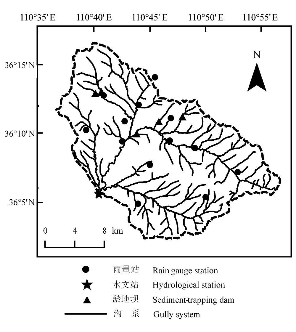
Fig. 1 Geographical position of Qingshui River watershed.
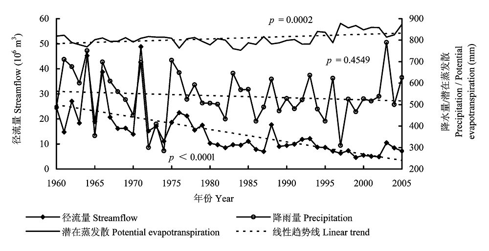
Fig. 2 Annual variation of streamflow, potential evapotranspiration, and precipitation with their respective linear regression line.
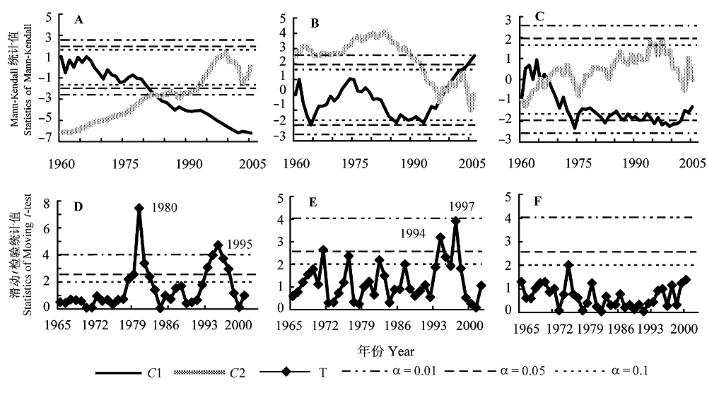
Fig. 3 Trend of annual streamflow, potential evapotranspiration, and precipitation in Qingshui River watershed from 1960 to 2005. A-C, The Mann-Kendall curves of streamflow, potential evapotranspiration, and precipitation, respectively. D-F, The Moving t-test curves of streamflow, potential evapotranspiration, and precipitation, respectively. C1, the curve of statistics of Mann-Kendall; C2, the curve of deserialized statistics of Mann-Kendall; T, statistics of Moving t-test; α, significance level.
| 年份 Year | 农地 Cropland | 乔木林地 Woodland | 灌木林地 Shrubland | 荒草地 Grassland | 居民区 Residential area | |
|---|---|---|---|---|---|---|
| 面积 Area (km2) | 1959 | 105.12 | 12.38 | 97.97 | 220.14 | 0.44 |
| 1986 | 44.52 | 115.71 | 91.12 | 183.86 | 0.78 | |
| 2007 | 37.28 | 129.19 | 116.89 | 157.70 | 2.88 | |
| 面积变化率 Area change rate (%) | 1959-1986 | -57.67 | 835.41 | -6.99 | -16.46 | 83.36 |
| 1986-2007 | -34.09 | 11.64 | 28.29 | -14.23 | 268.71 | |
| 1959-2007 | -72.10 | 944.27 | 19.33 | -28.35 | 576.07 |
Table 1 Area and the change rate of area of different land use types
| 年份 Year | 农地 Cropland | 乔木林地 Woodland | 灌木林地 Shrubland | 荒草地 Grassland | 居民区 Residential area | |
|---|---|---|---|---|---|---|
| 面积 Area (km2) | 1959 | 105.12 | 12.38 | 97.97 | 220.14 | 0.44 |
| 1986 | 44.52 | 115.71 | 91.12 | 183.86 | 0.78 | |
| 2007 | 37.28 | 129.19 | 116.89 | 157.70 | 2.88 | |
| 面积变化率 Area change rate (%) | 1959-1986 | -57.67 | 835.41 | -6.99 | -16.46 | 83.36 |
| 1986-2007 | -34.09 | 11.64 | 28.29 | -14.23 | 268.71 | |
| 1959-2007 | -72.10 | 944.27 | 19.33 | -28.35 | 576.07 |
| 基准段(1960-1980年) Baseline period (1960-1980) | 变化段(1981-2005年) Changed period (1981-2005) | ||||||
|---|---|---|---|---|---|---|---|
| 平均值 Mean | 标准偏差 SD | 变异系数 CV (%) | 平均值 Mean | 标准偏差 SD | 变异系数CV (%) | ||
| 径流量 Streamflow | 2.15×10⁷ m3 | 1.04×10⁷ m3 | 0.48 | 8.7×10⁶ m3 | 2.78×10⁶ m3 | 0.32 | |
| 潜在蒸发散 Potential evapotranspiration | 800.09 mm | 16.85 mm | 0.02 | 815.58 mm | 36.81 mm | 0.04 | |
| 降水量 Pricipitation | 552.30 mm | 137.48 mm | 0.25 | 528.50 mm | 95.41 mm | 0.18 | |
Table 2 Variations of annual streamflow, mean temperature, potential evapotranspiration and precipitation in Qingshui River watershed
| 基准段(1960-1980年) Baseline period (1960-1980) | 变化段(1981-2005年) Changed period (1981-2005) | ||||||
|---|---|---|---|---|---|---|---|
| 平均值 Mean | 标准偏差 SD | 变异系数 CV (%) | 平均值 Mean | 标准偏差 SD | 变异系数CV (%) | ||
| 径流量 Streamflow | 2.15×10⁷ m3 | 1.04×10⁷ m3 | 0.48 | 8.7×10⁶ m3 | 2.78×10⁶ m3 | 0.32 | |
| 潜在蒸发散 Potential evapotranspiration | 800.09 mm | 16.85 mm | 0.02 | 815.58 mm | 36.81 mm | 0.04 | |
| 降水量 Pricipitation | 552.30 mm | 137.48 mm | 0.25 | 528.50 mm | 95.41 mm | 0.18 | |
| 时段 Period | 降水量P (mm) | 潜在蒸发散E0 (mm) | 径流量 Q (mm) | $\Delta {{Q}^{tot}}^{{}}$(mm) | $\Delta {{\overline{Q}}^{c\lim }}$(mm) | $\Delta {{\overline{Q}}^{LUCC}}$(mm) |
|---|---|---|---|---|---|---|
| 1960-1980 | 552.3 | 800.09 | 50.98 | -32.29 | -15.11 | -17.18 |
| 1981-2005 | 528.5 | 815.58 | 18.69 |
Table 3 Effects of climate and landuse change on streamflow in the Qingshui River watershed
| 时段 Period | 降水量P (mm) | 潜在蒸发散E0 (mm) | 径流量 Q (mm) | $\Delta {{Q}^{tot}}^{{}}$(mm) | $\Delta {{\overline{Q}}^{c\lim }}$(mm) | $\Delta {{\overline{Q}}^{LUCC}}$(mm) |
|---|---|---|---|---|---|---|
| 1960-1980 | 552.3 | 800.09 | 50.98 | -32.29 | -15.11 | -17.18 |
| 1981-2005 | 528.5 | 815.58 | 18.69 |
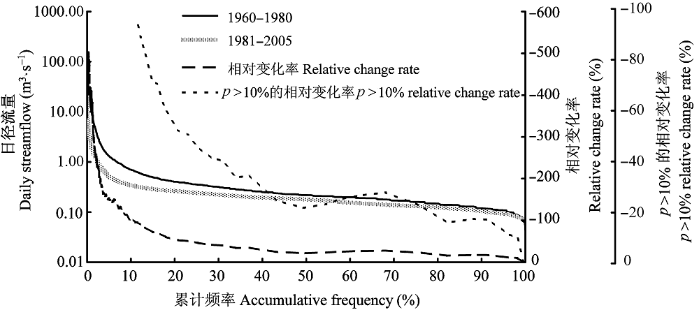
Fig. 4 Accumulated frequency distribution curve of baseline period and changed period (expressed as logarithmic curve).
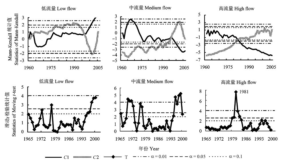
Fig. 5 Trend of different flow of annual streamflow in Qingshui River watershed from 1960 to 2005. C1, C2, T, α see Fig. 3.
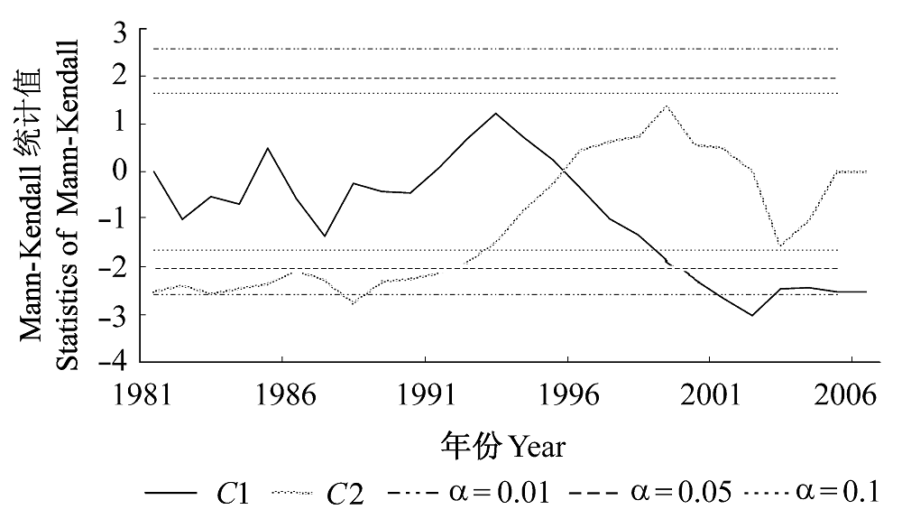
Fig. 6 Trend of annual streamflow from 1981 to 2005. C1, C2, T, α see Fig. 3.
| [1] | Afifi AA, Azen SP (1972). Statistical Analysis: A Computer Oriented Approach. Academic Press, New York. |
| [2] | Chen LQ (陈利群), Liu CM (刘昌明), Yang C (杨聪), Hao FH (郝芳华) (2006). Baseflow estimation of the source regions of the Yellow River. Geographical Research (地理研究), 25, 659-665. (in Chinese with English abstract) |
| [3] | Cong ZT, Yang DW, Gao B, Yang HB, Hu HP (2009). Hydrological trend analysis in the Yellow River basin using a distributed hydrological model. Water Resources Research, 45, W00A13, doi: 10.1029/2008WR006852. |
| [4] | Fu CB (符淙斌), Wang Q (王强) (1992). The definition and detection of the abrupt climate change. Scientia Atmosphere Sinica (大气科学), 16, 482-492, 366. (in Chinese with English abstract) |
| [5] | Goossens CH, Berger A (1986). Annual and seasonal climatic variations over the Northern Hemisphere and Europe during the last century. Annales Geophysicae, 4, 385-400. |
| [6] | Hamon WR (1963). Computation of direct runoff amounts from storm rainfall. International Association of Scientific Hydrology Publication, 63, 52-62. |
| [7] | Kendall MG (1955). Rank Correlation Methods. Griffin, London. |
| [8] | Li LJ, Zhang L, Wang H, Wang J, Yang JW, Jiang DJ, Li JY, Qin DY (2007). Assessing the impact of climate variability and human activities on streamflow from the Wuding River basin in China. Hydrological Processes, 25, 3485-3491. |
| [9] | Liu XQ (刘晓清), Zhao JB (赵景波), Yu XF (于学峰) (2006). Study on the climatic warming-drying trend in the Loess Plateau and the countermeasures. Arid Zone Research (干旱区研究), 23, 627-631. (in Chinese with English abstract) |
| [10] | Mann HB (1945). Non-parametric test against trend. Econometrica, 13, 245-259. |
| [11] | McCulloch JG, Robinson M (1993). History of forest hydrology. Journal of Hydrology, 150, 189-216. |
| [12] | McVicar TR, Li LT, van Niel TG, Zhang L, Li R, Yang QK, Zhang XP, Mu XM, Wen ZM, Liu WZ, Zhao YA, Liu ZH, Gao P (2007). Developing a decision support tool for China’s re-vegetation program: simulating regional impacts of afforestation on average annual streamflow in the Loess Plateau. Forest Ecology and Management, 251, 65-81. |
| [13] | Milly PCD, Dunne KA (2002). Macroscale water fluxes. 2. Water and energy supply control of their interannual variability. Water Resources Research, 38, 1206. |
| [14] | Mu XM, Zhang L, McVicar TR, Chille BS, Gao P (2007). Analysis of the impact of conservation measures on streamflow regime in catchments of the Loess Plateau, China. Hydrological Processes, 21, 2124-2134. |
| [15] | Ran DC (冉大川), Luo QH (罗全华), Liu B (刘斌), Wang H (王宏) (2004). Effect of soil-retaining dams on flood and sediment reduction in middle reaches of Yellow River. Journal of Hydraulic Engineering (水利学报), 5, 7-14. (in Chinese with English abstract) |
| [16] | Rui XF (芮孝芳) (2004). Hydrology Principle (水文学原理). China Water Power Press, Beijing. (in Chinese) |
| [17] | Tang LX (唐丽霞) (2009). Effects of Landuse/Climate Variability on the Runoff and Sediment in Qingshuihe Watershed on the Loess Plateau, West Shanxi Province, China (黄土高原清水河流域土地利用/气候变化对径流泥沙的影响). PhD dissertation, Beijing Forestry University, Beijing. 98. (in Chinese) |
| [18] | Vogel RM, Fennessey NM (1994). Flow-duration curves. I. New interpretation and confidence intervals. Journal of Water Resources Planning and Management, 120, 485-504. |
| [19] | Wang SP (王盛萍) (2007). Eco-Hydrological Response of a Small Watershed to Landuse Change and Climate Variation (典型小流域土地利用与气候变化的生态水文响应研究). PhD dissertation, Beijing Forestry University, Beijing. 37-38. (in Chinese) |
| [20] | Xu JH (徐建华), Wu FQ (吴发启) (2005). The Runoff and Sediment Yield Mechanism on Loess Plateau and the Influence Mechanism on Water and Sediment by Using Water Conservation Measures (黄土高原产流产沙机制及水土保持措施对水资源和泥沙影响的机理研究). Yellow River Water Conservancy Press, Zhengzhou. (in Chinese) |
| [21] | Xu ZX, Li JY, Liu CM (2007). Long-term trend analysis for major climate variables in the Yellow River basin. Hydrological Procesess, 21, 1935-1948. |
| [22] | Xu ZX (徐宗学), Sui CH (隋彩虹) (2005). Long-term trend of temperature in the Yellow River basin. Meteorological Monthly (气象), 31, 7-10. (in Chinese with English abstract) |
| [23] | Yan ZW (严中伟), Ji JJ (季劲钧), Ye DZ (叶笃正) (1990). Analysis of the process of 1960s northern hemispheric summer climatic jump―Change of precipitation and temperature. Science in China, Series B (中国科学(B辑)) 20, 97-103. (in Chinese) |
| [24] | Yang YX (杨雨行), Han XC (韩熙春) (1991). A report of the affect on flow and sediment by the development of forests in clear water watershed in Jixian County, Shanxi Province. Journal of Beijing Forestry University (北京林业大学学报), 13, 59-67. (in Chinese with English abstract) |
| [25] | Yao YB (姚玉璧), Wang YR (王毅荣), Li YH (李耀辉), Zhang XY (张秀云) (2005). Climate warming and drying and its environmental effects in the Loess Plateau. Resources Science (资源科学), 27, 146-152. (in Chinese with English abstract) |
| [26] | Zhang L, Dawes WR, Walker GR (2001). Response of mean annual evapotranspiration to vegetation changes at catchment scale. Water Resources Research, 37, 701-708. |
| [27] | Zhang JY (张建云), Wang GQ (王国庆) (2007). The Research of the Influence on the Climate Change to Hydrology Water Resources (气候变化对水文水资源影响研究). Science Press, Beijing. 182-205. (in Chinese) |
| [28] | Zhang XP, Zhang L, McVicar TR, Tom G, van Niel TG, Li LT, Li R, Yang QK, Wei L (2008a). Modeling the impact of afforestation on average annual streamflow in the Loess Plateau, China. Hydrological Processes, 22, 1996-2004. |
| [29] |
Zhang XP, Zhang L, Zhao J, Rustomji P, Hairsine P (2008b). Responses of streamflow to changes in climate and land use/cover in the Loess Plateau, China. Water Resources Research, 44, W00A07, doi: 10.1029/2007WR006711.
DOI URL PMID |
| [30] | Zhang ZQ, Wang SP, Sun G, McNulty SG, Zhang HY, Li JL, Zhang ML, Klaghofer E, Strauss P (2008c). Evaluation of the MIKESHE model for application in the Loess Plateau, China. Journal of the American Water Resources Association, 44, 1108-1120. |
| [31] | Zhou XH (周晓红), Zhao JB (赵景波) (2005). Climatic change and vegetation restoration on the Loess Plateau. Arid Zone Research (干旱区研究), 23, 116-119. (in Chinese with English abstract) |
| [1] | ZHANG Hong-Jin, WANG Wei. Responses of ecosystem multifunctionality to global change: progress, problem and prospect [J]. Chin J Plant Ecol, 2021, 45(10): 1112-1126. |
| [2] | NIU Shu-Li, CHEN Wei-Nan. Global change and ecosystems research progress and prospect [J]. Chin J Plant Ecol, 2020, 44(5): 449-460. |
| [3] | Edith BAI, XUE Bing. A review of influences of land use and land cover change on ecosystems [J]. Chin J Plant Ecol, 2020, 44(5): 543-552. |
| [4] | WANG Xiang, ZHU Ya-Qiong, ZHENG Wei, GUAN Zheng-Xuan, SHENG Jian-Dong. Soil respiration features of mountain meadows under four typical land use types in Zhaosu Basin [J]. Chin J Plant Ecol, 2018, 42(3): 382-396. |
| [5] | Hua JU, Guo-Zhen SHEN, Ming-Zhe MA, Jie-Lin GE, Wen-Ting XU, Chang-Ming ZHAO, Qiu- Liang ZHANG. Greenhouse gas fluxes of typical northern subtropical forest soils: Impacts of land use change and reduced precipitation [J]. Chin J Plant Ecol, 2016, 40(10): 1049-1063. |
| [6] | PENG Zi, GU Cheng-Yan, LIU Zhi-Yong, LIN Wen, ZHOU Ping. Impact of land use change during 1989-2009 on eco-capacity in Dongjiang watershed [J]. Chin J Plant Ecol, 2014, 38(7): 675-686. |
| [7] | ZHANG Zi-Yu,Gong Ji-Rui,LIU Min,HUANG Yong-Mei,YAN Xin,QI Yu,WANG Yi-Hui. Dominant species and ecosystem gas exchange in temperate grassland under different land use patterns [J]. Chin J Plant Ecol, 2013, 37(8): 718-727. |
| [8] | XU Li,YU Shu-Xia,HE Nian-Peng,WEN Xue-Fa,SHI Pei-Li,ZHANG Yang-Jian,DAI Jing-Zhong,WANG Ruo-Meng. Soil C mineralization and temperature sensitivity in alpine grasslands of the Qinghai-Xizang Plateau [J]. Chin J Plant Ecol, 2013, 37(11): 988-997. |
| [9] | SUN Xiao-Peng, WANG Tian-Ming, KOU Xiao-Jun, GE Jian-Ping. Normalized difference vegetation index dynamic change and its driving factor analysis with long time series in the Jinghe River watershed on the Loess Plateau of China [J]. Chin J Plant Ecol, 2012, 36(6): 511-521. |
| [10] | LI Ming, ZHU Li-Chuan, ZHANG Quan-Fa, CHENG Xiao-Li. Impacts of different land use types on soil nitrogen mineralization in Danjiangkou Reservoir Area, China [J]. Chin J Plant Ecol, 2012, 36(6): 530-538. |
| [11] | ZHANG Xiao-Ping, ZHANG Lu, LI Rui, YANG Qin-Ke. DEM-BASED MODELING OF THE IMPACT OF VEGETATION RESTORATION ON ANNUAL STREAMFLOW IN THE LOESS PLATEAU OF CHINA [J]. Chin J Plant Ecol, 2009, 33(6): 1056-1064. |
| [12] | YANG Hao, BAI Yong-Fei, LI Yong-Hong, HAN Xing-Guo. RESPONSE OF PLANT SPECIES COMPOSITION AND COMMUNITY STRUCTURE TO LONGTERM GRAZING IN TYPICAL STEPPE OF INNER MONGOLIA [J]. Chin J Plant Ecol, 2009, 33(3): 499-507. |
| [13] | ZHANG Lu, HUANG Jian-Hui, BAI Yong-Fei, HAN Xing-Guo. EFFECTS OF NITROGEN ADDITION ON NET NITROGEN MINERALIZATION IN LEYMUS CHINENSIS GRASSLAND, INNER MONGOLIA, CHINA [J]. Chin J Plant Ecol, 2009, 33(3): 563-569. |
| [14] | WANG Xiao-Chun, JI Ying. REVIEW OF ADVANCES IN DENDROPYROCHRONOLOGY [J]. Chin J Plant Ecol, 2009, 33(3): 587-597. |
| [15] | LI Zeng-Jia, MA You-Xin, LI Hong-Mei, PENG Ming-Chun, LIU Wun-Jun. RELATION OF LAND USE AND COVER CHANGE TO TOPOGRAPHY IN XISHUANGBANNA, SOUTHWEST CHINA [J]. Chin J Plant Ecol, 2008, 32(5): 1091-1103. |
| Viewed | ||||||
|
Full text |
|
|||||
|
Abstract |
|
|||||
Copyright © 2022 Chinese Journal of Plant Ecology
Tel: 010-62836134, 62836138, E-mail: apes@ibcas.ac.cn, cjpe@ibcas.ac.cn