
植物生态学报 ›› 2007, Vol. 31 ›› Issue (6): 1063-1072.DOI: 10.17521/cjpe.2007.0134
刘海江( ), 程维明, 龙恩
收稿日期:2006-05-10
接受日期:2006-08-21
出版日期:2007-05-10
发布日期:2007-11-30
作者简介:E-mail: liuhj@lreis.ac.cn
基金资助:
LIU Hai-Jiang(), CHENG Wei-Ming, LONG En
Received:2006-05-10
Accepted:2006-08-21
Online:2007-05-10
Published:2007-11-30
摘要:
生态系统变化会引起景观结构及格局的改变,而景观格局及其演化可以作为评价环境变化的指标。为了揭示浑善达克沙地生态系统变化特征,该文使用陆地卫星(Landsat 5、7)的TM/ETM+资料及地面调查数据来分析沙地景观变化特征。通过计算机监督分类,获得了研究区1987和2000年景观类型数据,研究区的景观类型有草地、固定沙地、半固定沙地、流动沙地、灌木林及水体。通过对两期景观数据的基本特征、变化检测及转移矩阵分析发现:1)从1987到2000年,草原、固定沙地、半固定沙地都在减少,斑块破碎,而流动沙地显著增加,成为主要景观类型,同时斑块相互联合形成两条流动沙带;2)类型转移上,草原转为沙地,固定沙地主要转为半固定沙地,半固定沙地以绝对优势转为流动沙地,水体转为流动沙地及草原;3)变化监测显示,流动沙地增加面积远远大于减少的面积,而草原、固定沙地、半固定沙地呈现相反趋势,变化区域的空间分布也不尽相同。结果表明研究区沙地生态系统已经退化比较严重,特别是流动沙带的出现,需要采取积极有效的防治措施,防止进一步扩大。
刘海江, 程维明, 龙恩. 受损沙地生态系统景观变化分析——以内蒙古浑善达克沙地为例. 植物生态学报, 2007, 31(6): 1063-1072. DOI: 10.17521/cjpe.2007.0134
LIU Hai-Jiang, CHENG Wei-Ming, LONG En. LANDSCAPE CHANGES IN A DEGRADED SANDY LAND ECOSYSTEM—A CASE STUDY IN THE OTINDAG SANDY LAND, INNER MONGOLIA, CHINA. Chinese Journal of Plant Ecology, 2007, 31(6): 1063-1072. DOI: 10.17521/cjpe.2007.0134
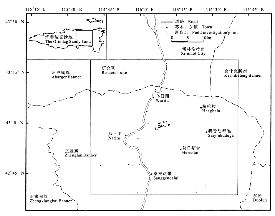
图1 研究区位置图
Fig.1 The location of study area
| 景观类型 Landscape types | 特征 Feature | ||||||
|---|---|---|---|---|---|---|---|
| 水域 Water | 沙地中分布的大大小小的湖泊(淖尔) Different sizes of lakes are distributed in the sandy land | ||||||
| 灌木林 Shrub | 分布在丘间洼地上或河流两岸、湖泊周围,建群种为小红柳 This community is dominated by shrub Salix microstachya var. bordensis and mainly distributed on riverside, lakeshore and depression in interdune plain | ||||||
| 草原 Grassland | 分布于丘间的平沙地上,群落物种为典型草原常见种,以糙隐子草、冷蒿、苔草、冰草为优势种,局部地下水位高的地方,生长以西伯利亚剪股颖、鹅绒委陵菜、金戴戴为优势种的草甸 This community is distributed in interdune plain, and the dominate species include Cleistogenes squarrosa, Artemisia frigida, Agropyron cristatum and Carex sp., which are the common species occurring in typical grassland community. Another community occurs in the area with high water level, which is just like meadow. Preponderant species are Agrostis sibirica, Potentilla anserina and Halerpestes ruthenica | ||||||
| 固定沙地 Fixed sandy land | 包括缓起伏沙地和沙丘,都有茂密的植被覆盖,有些地方地表有结皮 This landscape includes two landforms. One is gently waved sandland and the other is sand dunes. All of them are covered by flourishing vegetation. Soil crust generates in some places | ||||||
| 半固定沙地 Semi-fixed sandy land | 包括缓起伏沙地和沙丘,物种主要为沙生及一年生物种,群落结构尚未形成,基质不稳定 This landscape includes two landforms. One is gently waved sandland and the other is sand dune. The species are mainly psammophyte and annual plants, and community structure does not exist | ||||||
| 流动沙地 Mobile sandy dune | 植被稀疏,基质裸露,物种主要为一年生先锋物种 This landscape is characterized by very sparse annual pioneer plants and mobile sand substrate | ||||||
表1 研究区景观类型特征
Table 1 Features of landscape types at study area
| 景观类型 Landscape types | 特征 Feature | ||||||
|---|---|---|---|---|---|---|---|
| 水域 Water | 沙地中分布的大大小小的湖泊(淖尔) Different sizes of lakes are distributed in the sandy land | ||||||
| 灌木林 Shrub | 分布在丘间洼地上或河流两岸、湖泊周围,建群种为小红柳 This community is dominated by shrub Salix microstachya var. bordensis and mainly distributed on riverside, lakeshore and depression in interdune plain | ||||||
| 草原 Grassland | 分布于丘间的平沙地上,群落物种为典型草原常见种,以糙隐子草、冷蒿、苔草、冰草为优势种,局部地下水位高的地方,生长以西伯利亚剪股颖、鹅绒委陵菜、金戴戴为优势种的草甸 This community is distributed in interdune plain, and the dominate species include Cleistogenes squarrosa, Artemisia frigida, Agropyron cristatum and Carex sp., which are the common species occurring in typical grassland community. Another community occurs in the area with high water level, which is just like meadow. Preponderant species are Agrostis sibirica, Potentilla anserina and Halerpestes ruthenica | ||||||
| 固定沙地 Fixed sandy land | 包括缓起伏沙地和沙丘,都有茂密的植被覆盖,有些地方地表有结皮 This landscape includes two landforms. One is gently waved sandland and the other is sand dunes. All of them are covered by flourishing vegetation. Soil crust generates in some places | ||||||
| 半固定沙地 Semi-fixed sandy land | 包括缓起伏沙地和沙丘,物种主要为沙生及一年生物种,群落结构尚未形成,基质不稳定 This landscape includes two landforms. One is gently waved sandland and the other is sand dune. The species are mainly psammophyte and annual plants, and community structure does not exist | ||||||
| 流动沙地 Mobile sandy dune | 植被稀疏,基质裸露,物种主要为一年生先锋物种 This landscape is characterized by very sparse annual pioneer plants and mobile sand substrate | ||||||
| 景观类型 Landscape types | 时间 Time | 斑块数 No. of patches | 平均斑块面积 Mean patch area (km2) | 标准偏差 SD | 总面积 Total area (km2) | 百分比 Percentage (%) |
|---|---|---|---|---|---|---|
| 水域 Water | 1987 2000 | 19 22 | 2.04 1.76 | 2.98 2.05 | 38.74 38.66 | 0.77 0.77 |
| 灌木林 Shrub | 1987 2000 | 99 178 | 1.42 1.28 | 2.21 3.16 | 140.37 228.57 | 2.80 4.56 |
| 草原 Grassland | 1987 2000 | 491 435 | 3.59 3.70 | 14.50 22.46 | 1 762.40 1 611.48 | 35.16 32.14 |
| 固定沙地 Fixed sandy land | 1987 2000 | 124 263 | 10.60 3.52 | 52.15 12.17 | 1 314.68 926.70 | 26.23 18.48 |
| 半固定沙地 Semi-fixed sandy land | 1987 2000 | 149 370 | 9.86 3.32 | 37.42 14.93 | 1 468.97 1 227.76 | 29.30 24.49 |
| 流动沙地 Mobile sandy dune | 1987 2000 | 101 81 | 2.85 12.10 | 4.94 45.58 | 287.69 980.10 | 5.74 19.55 |
表2 研究区1987和2000年景观格局
Table 2 Landscape pattern at study area in 1987 and 2000
| 景观类型 Landscape types | 时间 Time | 斑块数 No. of patches | 平均斑块面积 Mean patch area (km2) | 标准偏差 SD | 总面积 Total area (km2) | 百分比 Percentage (%) |
|---|---|---|---|---|---|---|
| 水域 Water | 1987 2000 | 19 22 | 2.04 1.76 | 2.98 2.05 | 38.74 38.66 | 0.77 0.77 |
| 灌木林 Shrub | 1987 2000 | 99 178 | 1.42 1.28 | 2.21 3.16 | 140.37 228.57 | 2.80 4.56 |
| 草原 Grassland | 1987 2000 | 491 435 | 3.59 3.70 | 14.50 22.46 | 1 762.40 1 611.48 | 35.16 32.14 |
| 固定沙地 Fixed sandy land | 1987 2000 | 124 263 | 10.60 3.52 | 52.15 12.17 | 1 314.68 926.70 | 26.23 18.48 |
| 半固定沙地 Semi-fixed sandy land | 1987 2000 | 149 370 | 9.86 3.32 | 37.42 14.93 | 1 468.97 1 227.76 | 29.30 24.49 |
| 流动沙地 Mobile sandy dune | 1987 2000 | 101 81 | 2.85 12.10 | 4.94 45.58 | 287.69 980.10 | 5.74 19.55 |
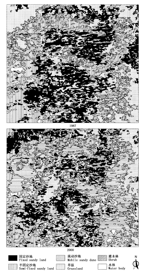
图2 研究区1987和2000年景观监督分类图
Fig.2 Supervised classification maps of landscape types at study area in 1987 and 2000
| 1987 | 2000 | |||||
|---|---|---|---|---|---|---|
| 水域 Water | 灌木林 Shrub | 草原 Grassland | 固定沙地 Fixed sandy land | 半固定沙地 Semi-fixed sandy land | 流动沙地 Mobile sandy dune | |
| 水域 Water | 30.88 79.50% | 0.60 1.55% | 3.41 8.77% | 0.14 0.37% | 0.21 0.55% | 3.60 9.26% |
| 灌木林 Shrub | 3.90 2.78% | 113.11 80.68% | 14.09 10.05% | 6.45 4.60% | 0.99 0.71% | 1.66 1.18% |
| 草原 Grassland | 1.40 0.08% | 42.66 2.42% | 989.23 56.04% | 282.45 16.00% | 260.61 14.76% | 199.95 10.70% |
| 固定沙地 Fixed sandy land | 0.42 0.03% | 63.32 4.81% | 362.14 27.50% | 553.37 42.02% | 325.26 24.70% | 12.26 0.93% |
| 半固定沙地 Semi-fixed sandy land | 1.25 0.09% | 7.13 0.48% | 231.90 15.76% | 84.95 5.77% | 623.61 42.38% | 522.49 35.51% |
| 流动沙地 Mobile sandy dune | 0.87 0.30% | 1.45 0.50% | 13.48 4.68% | 0.84 0.29% | 19.42 6.75% | 251.75 87.47% |
表3 研究区1987到2000年景观类型的转移面积(km2)和转移百分比
Table 3 The transition area (km2) and percentage among landscape types at study area from 1987 to 2000
| 1987 | 2000 | |||||
|---|---|---|---|---|---|---|
| 水域 Water | 灌木林 Shrub | 草原 Grassland | 固定沙地 Fixed sandy land | 半固定沙地 Semi-fixed sandy land | 流动沙地 Mobile sandy dune | |
| 水域 Water | 30.88 79.50% | 0.60 1.55% | 3.41 8.77% | 0.14 0.37% | 0.21 0.55% | 3.60 9.26% |
| 灌木林 Shrub | 3.90 2.78% | 113.11 80.68% | 14.09 10.05% | 6.45 4.60% | 0.99 0.71% | 1.66 1.18% |
| 草原 Grassland | 1.40 0.08% | 42.66 2.42% | 989.23 56.04% | 282.45 16.00% | 260.61 14.76% | 199.95 10.70% |
| 固定沙地 Fixed sandy land | 0.42 0.03% | 63.32 4.81% | 362.14 27.50% | 553.37 42.02% | 325.26 24.70% | 12.26 0.93% |
| 半固定沙地 Semi-fixed sandy land | 1.25 0.09% | 7.13 0.48% | 231.90 15.76% | 84.95 5.77% | 623.61 42.38% | 522.49 35.51% |
| 流动沙地 Mobile sandy dune | 0.87 0.30% | 1.45 0.50% | 13.48 4.68% | 0.84 0.29% | 19.42 6.75% | 251.75 87.47% |
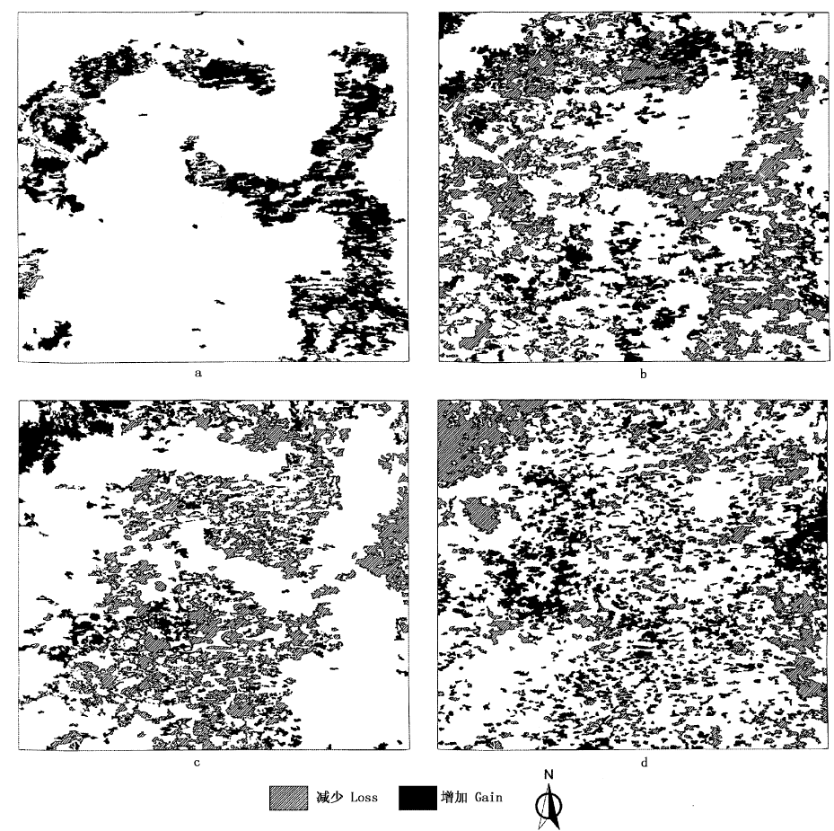
图3 研究区4种主要景观类型1987~2000年间的空间变化 a为流动沙地,b为半固定沙地,c为固定沙地,d为草原
Fig.3 Spatial changes of four dominant landscape types from 1987 to 2000 at study area a, b, c and d represent active sandy land, semi-fixed sandy land, fixed sandy land and grassland, respectively
| [1] | Bock M, Rossner G, Wissen M, Remm K, Langanke T, Lang S, Klug H, Blaschke T, Vršcaj B (2005). Spatial indicators for nature conservation from European to local scale. Ecological Indicators, 5,322-338. |
| [2] | Dale VH, Beyeler SC (2001). Challenges in the development and use of ecological indicators. Ecological Indicators, 1,3-10. |
| [3] | Ding GD (丁国栋), Cai JY (蔡京艳), Wang X (王贤), Dong Z (董智), Fan JY (范建友), Chen PP (陈平平) (2004). Causes, process and countermeasures of desertification in Hunshandake Sandland: taking Zhenglan Banner, Inner Mongolia as an example. Journal of Beijing Forestry University (北京林业大学学报), 26(4),15-19. (in Chinese with English abstract) |
| [4] | Fan JY (范建友), Ding GD (丁国栋), Guan BY (关博源), Wang X (王贤), Li SY (李素艳), Yang TT (杨婷婷) (2005). Monitoring remote sensing of dynamic change of vegetation coverage in Zhenglan Banner. Science of Soil and Water Conservation (中国水土保持科学), 3(4),54-59. (in Chinese with English abstract) |
| [5] | Fu BJ, Hu CH, Chen LD, Honnay O, Gulinck H (2006). Evaluating change in agricultural landscape pattern between 1980 and 2000 in the Loess hilly region of Ansai County, China. Agriculture Ecosystems & Environment, 114,387-396. |
| [6] |
Griffith RK, Stehman SV, Loveland TR (2003). Landscape trends in mid-Atlantic and southeastern U.S. ecoregions. Environmental Management, 32,572-588.
DOI URL PMID |
| [7] | Guo K (郭柯), Dong XJ (董学军), Liu ZM (刘志茂) (2000). Characteristics of soil moisture content on sand dunes in Mu Us Sandy grassland: why Artemisia ordosica declines on old fixed sand dunes. Acta Phytoecologica Sinica (植物生态学报), 24,275-279. (in Chinese with English abstract) |
| [8] | Guo K (郭柯), Liu HJ (刘海江) (2004). A comparative researches in the development of seedlings in four habitats in the Hunshandak Sandland, Inner Mongolia, China. Acta Ecologica Sinica (生态学报), 24,2024-2028. (in Chinese with English abstract) |
| [9] | He Q (何晴), Lü DR (吕达仁) (2003). Monitoring vegetation cover change in east Hunshandake Sandy Land with Landsat TM and ETM + and its possible causes. Remote Sensing Technology and Application (遥感技术与应用), 18,353-359. (in Chinese with English abstract) |
| [10] | Hugenholtz CH, Wolfe SA (2005). Recent stabilization of active sand dunes on the Canadian prairies and relation to recent climate variations. Geomorphology, 68,121-147. |
| [11] | Li QF (李青丰), Hu CY (胡春元), Wang MJ (王明玖) (2001). Analysis on the causes of eco-environmental deterioration in Hunshandake Sandy Land region and countermeasures. Journal of Arid Land Resources and Environment (干旱区资源与环境), 15,9-16. (in Chinese with English abstract) |
| [12] | Liu SL (刘树林), Wang T (王涛) (2004). Primary study on sandy desertification in Otindag Sandy Land and its surrounding regions. Journal of Soil and Water Conservation (水土保持学报), 18,99-103. (in Chinese with English abstract) |
| [13] | Liu MZ (刘美珍), Jiang GM (蒋高明), Yu SL (于顺利), Li YG (李永庚), Gao LM (高雷明), Niu SL (牛书丽), Jiang CD (姜闯道), Peng Y (彭羽) (2004). Dynamics of plant community traite during an 18-year natural restoration in the degraded sandy grassland of Hunshandak Sandland. Acta Ecologica Sinica (生态学报), 24,1734-1740. (in Chinese with English abstract) |
| [14] | Olsen LM, Dale VH, Foster T (2007). Landscape pattern as indicators of ecological change at Fort Benning, Georgia, USA. Landscape and Urban Planning, 79,137-149. |
| [15] | Peterseil J, Wrbka T, Plutzar C, Schmitzberger I, Kiss A, Szerencsits E, Reiter K, Schneider W, Suppan F, Beissmann H (2004). Evaluating the ecological sustainability of Austrian agricultural landscapes—the SINUS approach. Land Use Policy, 21,307-320. |
| [16] | Potschin M, Haines-Young R (2006). “Rio+10”, sustainability science and landscape ecology. Landscape and Urban Planning, 75,162-174. |
| [17] | Turner MG (2005). Landscape ecology: what is the state of the science? Annual Review of Ecology Evolution and Systematics, 36,319-344. |
| [18] | United Scientific Exploration Team of Inner Mongolia and Ningxia, Chinese Academy of Sciences (中国科学院内蒙古宁夏综合科考队) (1985). Vegetation of Inner Mongolia (内蒙古植被). Science Press, Beijing, 766. (in Chinese) |
| [19] | Wang X (王贤), Ding GD (丁国栋), Cai JY (蔡京艳), Chen PP (陈平平), Fan JY (范建友), Li SY (李素艳) (2004). Causes and comprehensive control measures of desertification in Hunshandake Sand Land. Journal of Soil and Water Conservation (水土保持学报), 18,147-150. (in Chinese with English abstract) |
| [20] | Wang GL (王革丽), Lü D R (吕达仁), You L (尤莉) (2002). Analyses of climatic characteristics on Hunshandake dust storm. Climatic and Environmental Research (气候与环境研究), 7,433-439. (in Chinese with English abstract) |
| [21] | Wrbka T, Erb KH, Schulz NB, Peterseil J, Hahn C, Haberl H (2004). Linking pattern and process in cultural landscapes. An empirical study based on spatially explicit indicators. Land Use Policy, 21,289-306. |
| [22] | Wu JG (邬建国) (2000). Landscape Ecology: Pattern, Process, Scale and Hierarchy (景观生态学——格局、过程、尺度与等级). Higher Education Press, Beijing, 11. (in Chinese) |
| [23] | Wu JG (邬建国) (2004). The key research topics in landscape ecology. Acta Ecologica Sinica (生态学报), 24,2074-2076. (in Chinese with English abstract) |
| [24] | Wu JG (2006). Landscape ecology, cross-disciplinarity, and sustainability science. Landscape Ecology, 21,1-4. |
| [25] | Wu XP (吴晓莆), Tang ZY (唐志尧), Cui HT (崔海亭), Fang JY (方精云) (2006). Land cover dynamics of different topographic conditions in Beijing. Journal of Plant Ecology (Chinese Version) (formerly Acta Phytoecologica Sinica) (植物生态学报), 30,239-251. (in Chinese with English abstract) |
| [26] | Yang SK (杨淑宽), Chen JS (陈静生), Guo XM (郭蓄民) (1962). Exploration of Xiaotenggeli Sandy Land. In: Sand Controlling Team of Chinese Academy of Sciences (中国科学院治沙队) ed. Sand Controlling (治沙研究). Science Press, Beijing, 3,144-151. (in Chinese) |
| [27] | Yang SK (杨淑宽) (1964). The vegetation of Xiaotenggeli Sandy Land in Inner Mongolia. Geographical Research (地理研究), 8,32-46. (in Chinese) |
| [28] | Zhao SQ (赵松乔), Yang LP (杨利普), Yang QY (杨勤业) (1990). The Arid Region of China (中国的干旱区). Science Press, Beijing, 38. (in Chinese) |
| [29] | Zheng YR, Xue ZX, Robert C, Jiang LH, Shimizu H (2006). Did climate drive ecosystem change and induce desertification in Otindag Sandy Land, China over the past 40 years? Journal of Arid Environments, 64,523-541. |
| [30] | Zhu ZD (朱震达), Chen GT (陈广庭) (1994). Sandy Desertification in China (中国土地沙质荒漠化). Science Press, Beijing, 20. (in Chinese) |
| [31] | Zhu HY (朱会义), Li XB (李秀彬) (2003). Discussion on the index method of regional land use change. Acta Geographica Sinica (地理学报), 58,643-650. (in Chinese with English abstract) |
| [1] | 郝晴, 黄昌. 森林地上生物量遥感估算研究综述[J]. 植物生态学报, 2023, 47(10): 1356-1374. |
| [2] | 丛楠, 张扬建, 朱军涛. 北半球中高纬度地区近30年植被春季物候温度敏感性[J]. 植物生态学报, 2022, 46(2): 125-135. |
| [3] | 姜艳, 陈兴芳, 杨旭杰. 基于Landsat影像的武汉东湖30年来水生植物动态变化[J]. 植物生态学报, 2022, 46(12): 1551-1561. |
| [4] | 田佳玉, 王彬, 张志明, 林露湘. 光谱多样性在植物多样性监测与评估中的应用[J]. 植物生态学报, 2022, 46(10): 1129-1150. |
| [5] | 严正兵, 刘树文, 吴锦. 高光谱遥感技术在植物功能性状监测中的应用与展望[J]. 植物生态学报, 2022, 46(10): 1151-1166. |
| [6] | 薛鹏飞, 李文龙, 朱高峰, 周华坤, 刘陈立, 晏和飘. 黄河首曲玛曲县高寒湿地景观格局演变[J]. 植物生态学报, 2021, 45(5): 467-475. |
| [7] | 陈哲, 汪浩, 王金洲, 石慧瑾, 刘慧颖, 贺金生. 基于物候相机归一化植被指数估算高寒草地植物地上生物量的季节动态[J]. 植物生态学报, 2021, 45(5): 487-495. |
| [8] | 郭庆华, 胡天宇, 马勤, 徐可心, 杨秋丽, 孙千惠, 李玉美, 苏艳军. 新一代遥感技术助力生态系统生态学研究[J]. 植物生态学报, 2020, 44(4): 418-435. |
| [9] | 张富广, 曾彪, 杨太保. 气候变化背景下近30年祁连山高寒荒漠分布时空变化[J]. 植物生态学报, 2019, 43(4): 305-319. |
| [10] | 宁瑶, 雷金睿, 宋希强, 韩淑梅, 钟云芳. 石灰岩特有植物海南凤仙花潜在适宜生境分布模拟[J]. 植物生态学报, 2018, 42(9): 946-954. |
| [11] | 张峰,周广胜. 植被含水量高光谱遥感监测研究进展[J]. 植物生态学报, 2018, 42(5): 517-525. |
| [12] | 吴秀芝, 阎欣, 王波, 刘任涛, 安慧. 荒漠草地沙漠化对土壤-微生物-胞外酶化学计量特征的影响[J]. 植物生态学报, 2018, 42(10): 1022-1032. |
| [13] | 王克清, 王鹤松, 孙建新. 遥感GPP模型在中国地区多站点的应用与比较[J]. 植物生态学报, 2017, 41(3): 337-347. |
| [14] | 高林, 王晓菲, 顾行发, 田庆久, 焦俊男, 王培燕, 李丹. 植冠下土壤类型差异对遥感估算冬小麦叶面积指数的影响[J]. 植物生态学报, 2017, 41(12): 1273-1288. |
| [15] | 刘涛宇, 赵霞, 沈海花, 胡会峰, 黄文江, 方精云. 灌丛化草原灌木和草本植物光谱特征差异及灌木盖度反演——以内蒙古镶黄旗为例[J]. 植物生态学报, 2016, 40(10): 969-979. |
| 阅读次数 | ||||||
|
全文 |
|
|||||
|
摘要 |
|
|||||
Copyright © 2022 版权所有 《植物生态学报》编辑部
地址: 北京香山南辛村20号, 邮编: 100093
Tel.: 010-62836134, 62836138; Fax: 010-82599431; E-mail: apes@ibcas.ac.cn, cjpe@ibcas.ac.cn
备案号: 京ICP备16067583号-19