
植物生态学报 ›› 2017, Vol. 41 ›› Issue (3): 337-347.DOI: 10.17521/cjpe.2016.0182 cstr: 32100.14.cjpe.2016.0182
所属专题: 生态遥感及应用
王克清, 王鹤松*( ), 孙建新
出版日期:2017-03-10
发布日期:2017-04-12
作者简介:* 通信作者Author for correspondence (E-mail:基金资助:
Ke-Qing WANG, He-Song WANG*(), Osbert Jianxin SUN
Online:2017-03-10
Published:2017-04-12
About author:KANG Jing-yao(1991-), E-mail: 摘要:
在区域和全球尺度上估算植被总初级生产力(GPP)对理解陆地生态系统的碳循环具有重要意义。由于地表异质性的存在, 局限在站点尺度上的观测数据无法直接扩展到更大空间尺度的区域上。通过与地面观测数据相结合, 遥感成为实现植被GPP空间扩展的主要工具。但是现有模型对气象数据依赖较多, 且在不同气象数据集的驱动下, 模拟结果间会有差异, 进而产生不确定性。建立以遥感数据为主的GPP模型(简称遥感GPP模型), 使其易于在区域和全球尺度上应用, 是解决上述问题的一个可行方案。该研究使用TG (temperature and greenness model)和VI (vegetation index model)两个遥感GPP模型, 结合中国通量观测研究联盟(ChinaFLUX)的台站数据, 对中国典型植被类型的GPP进行了模拟、比较与评估, 旨在进一步提高遥感GPP模型在中国区域的适用性。结果表明: (1) TG和VI模型选用的遥感参数均与GPP观测值有较高的相关性, 都可以得到可信的光合转换系数m和a。基于与夜间地表温度平均值的相关关系, m和a在空间尺度上得到了扩展, 这使得TG和VI都可以应用到区域尺度上。(2) TG和VI模型的模拟值与实测值间的相关性大多较高, 决定系数(R2)多在0.67以上。但不同台站间的误差变动较大, TG模型的均方根误差为0.29-6.40 g·m-2·d-1, VI模型的均方根误差为0.31-7.09 g·m-2·d-1。(3)总体而言, TG模型的表现优于VI, 尤其在海拔或纬度较高、以温度限制为主的台站, TG模型的模拟效果较好。上述结果初步揭示遥感GPP模型具备了在区域尺度上应用的潜力。
王克清, 王鹤松, 孙建新. 遥感GPP模型在中国地区多站点的应用与比较. 植物生态学报, 2017, 41(3): 337-347. DOI: 10.17521/cjpe.2016.0182
Ke-Qing WANG, He-Song WANG, Osbert Jianxin SUN. Application and comparison of remote sensing GPP models with multi-site data in China. Chinese Journal of Plant Ecology, 2017, 41(3): 337-347. DOI: 10.17521/cjpe.2016.0182
| 植被类型 Vegetation type | 站点名称 Site name | 地理位置 Geo-location | 数据时段 Data period |
|---|---|---|---|
| 灌丛 Shrubland | 海北高寒草甸生态系统通量观测站 Haibei Alpine Meadow Ecosystem Flux Observation Site | 37.67° N, 101.33° E | 2003-2005 |
| 常绿阔叶林 Evergreen broad-leaved forest | 鼎湖山南亚热带常绿阔叶林通量观测站 Dinghushan South Subtropical Evergreen Broad-leaved Forest Flux Observation Site | 23.17° N, 112.54° E | 2003-2005 |
| 温带草原 Temperate steppe | 锡林郭勒温性典型草原通量观测站 Xilingol Temperate Grassland Flux Observation Site | 43.53° N, 116.67° E | 2004-2005 |
| 常绿针叶林 Evergreen needle-leaved forest | 千烟洲人工林通量观测站 Qianyanzhou Planted Forest Flux Observation Site | 26.74° N, 115.06° E | 2003-2005 |
| 农田 Cropland | 禹城暖温带半湿润旱作农田通量观测站 Yucheng Warmer Temperate Dry Farming Cropland Flux Observation Site | 36.83° N, 116.57° E | 2003-2005 |
| 高寒草甸 Alpine meadow | 当雄高寒草甸碳通量观测站 Damxung Alpine Meadow Flux Observation Site | 30.83° N, 91.12° E | 2004-2005 |
| 针阔混交林 Mixed broadleaf-conifer forest | 长白山温带红松阔叶林通量观测站 Changbaishan Temperate Broad-leaved Korean Pine Forest Flux Observation Site | 42.40° N, 128.07° E | 2003-2005 |
| 热带雨林 Tropical rain forest | 西双版纳热带雨林通量观测站 Xishuangbanna Tropical Rainforest Flux Observation Site | 21.93° N, 101.20° E | 2003-2005 |
表1 研究站点基本信息
Table 1 Basic information of the study sites
| 植被类型 Vegetation type | 站点名称 Site name | 地理位置 Geo-location | 数据时段 Data period |
|---|---|---|---|
| 灌丛 Shrubland | 海北高寒草甸生态系统通量观测站 Haibei Alpine Meadow Ecosystem Flux Observation Site | 37.67° N, 101.33° E | 2003-2005 |
| 常绿阔叶林 Evergreen broad-leaved forest | 鼎湖山南亚热带常绿阔叶林通量观测站 Dinghushan South Subtropical Evergreen Broad-leaved Forest Flux Observation Site | 23.17° N, 112.54° E | 2003-2005 |
| 温带草原 Temperate steppe | 锡林郭勒温性典型草原通量观测站 Xilingol Temperate Grassland Flux Observation Site | 43.53° N, 116.67° E | 2004-2005 |
| 常绿针叶林 Evergreen needle-leaved forest | 千烟洲人工林通量观测站 Qianyanzhou Planted Forest Flux Observation Site | 26.74° N, 115.06° E | 2003-2005 |
| 农田 Cropland | 禹城暖温带半湿润旱作农田通量观测站 Yucheng Warmer Temperate Dry Farming Cropland Flux Observation Site | 36.83° N, 116.57° E | 2003-2005 |
| 高寒草甸 Alpine meadow | 当雄高寒草甸碳通量观测站 Damxung Alpine Meadow Flux Observation Site | 30.83° N, 91.12° E | 2004-2005 |
| 针阔混交林 Mixed broadleaf-conifer forest | 长白山温带红松阔叶林通量观测站 Changbaishan Temperate Broad-leaved Korean Pine Forest Flux Observation Site | 42.40° N, 128.07° E | 2003-2005 |
| 热带雨林 Tropical rain forest | 西双版纳热带雨林通量观测站 Xishuangbanna Tropical Rainforest Flux Observation Site | 21.93° N, 101.20° E | 2003-2005 |
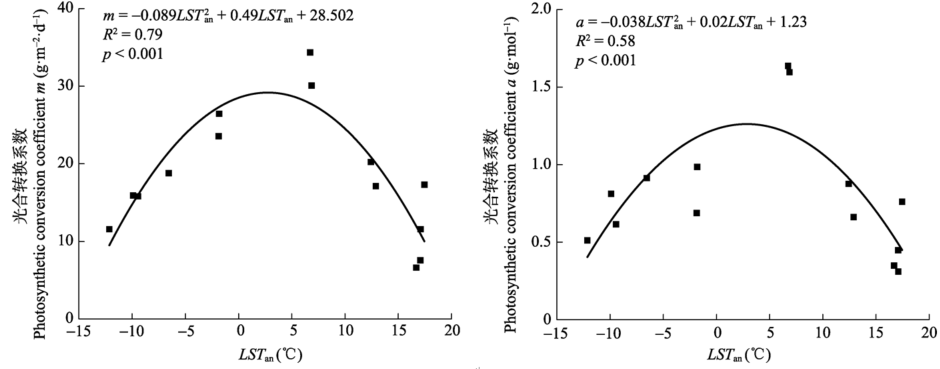
图1 光合转换系数m和a与年平均夜间地表温度值(LSTan)的关系。
Fig. 1 Relationships of the photosynthetic conversion coefficient m and a with annual mean nighttime land surface temperature (LSTan).
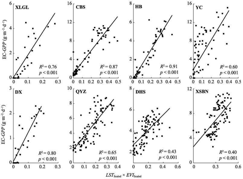
图2 不同站点涡度协相关总初级生产力(EC-GPP)与扩展地表温度(LSTScaled)和扩展增强植被指数(EVIScaled)的乘积之间的关系。CBS, 长白山温带红松阔叶林通量观测站; DHS, 鼎湖山南亚热带常绿阔叶林通量观测站; DX, 当雄高寒草甸碳通量观测站; HB, 海北高寒草甸生态系统通量观测站; QYZ, 千烟洲人工林通量观测站; XLGL, 锡林郭勒温性典型草原通量观测站; XSBN, 西双版纳热带雨林通量观测站; YC, 禹城暖温带半湿润旱作农田通量观测站。
Fig. 2 Relationships between the eddy covariance gross primary production (EC-GPP) and the product of the scaled land surface temperature (LSTScaled) multiplied by the scaled enhance vegetation index (EVIScaled) for different study sites. CBS, Changbaishan Temperate Broad-leaved Korean Pine Forest Flux Observation Site; DHS, Dinghushan South Subtropical Evergreen Broadleaved Forest Flux Observation Site; DX, Damxung Alpine Meadow Flux Observation Site; HB, Haibei Alpine Meadow Ecosystem Flux Observation Site; QYZ, Qianyanzhou Planted Forest Flux Observation Site; XLGL, Xilingol Temperate Grassland Flux Observation Site; XSBN, Xishuangbanna Tropical Rainforest Flux Observation Site; YC, Yucheng Warmer Temperate Dry Farming Cropland Flux Observation Site.
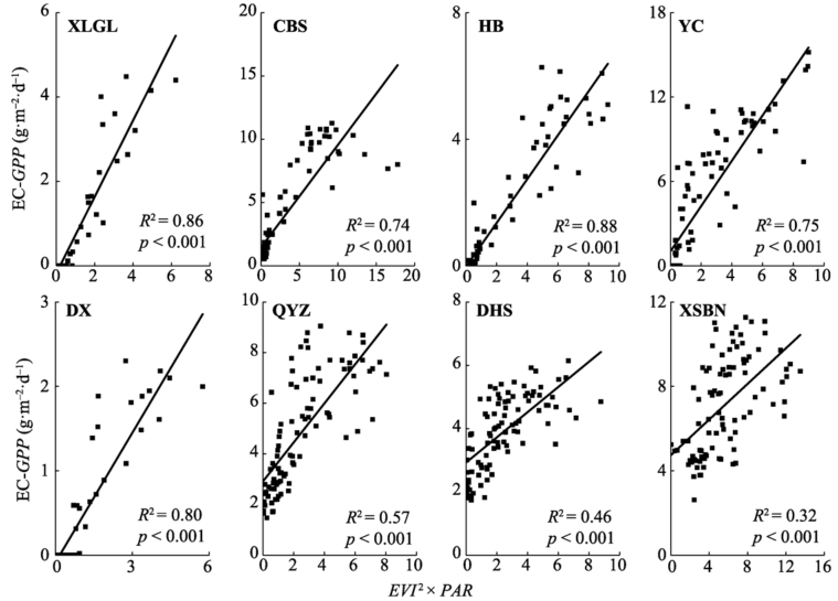
图3 不同站点涡度协相关总初级生产力(EC-GPP)与增强植被指数(EVI)的平方值和光合有效辐射(PAR)的乘积之间的关系。CBS, 长白山温带红松阔叶林通量观测站; DHS, 鼎湖山南亚热带常绿阔叶林通量观测站; DX, 当雄高寒草甸碳通量观测站; HB, 海北高寒草甸生态系统通量观测站; QYZ, 千烟洲人工林通量观测站; XLGL, 锡林郭勒温性典型草原通量观测站; XSBN, 西双版纳热带雨林通量观测站; YC, 禹城暖温带半湿润旱作农田通量观测站。
Fig. 3 Relationships between the eddy covariance gross primary production (EC-GPP) and the product of the enhanced vegetation index (EVI) multiplied by photosynthetic active radiation (PAR) for different study sites. CBS, Changbaishan Temperate Broad-leaved Korean Pine Forest Flux Observation Site; DHS, Dinghushan South Subtropical Evergreen Broadleaved Forest Flux Observation Site; DX, Damxung Alpine Meadow Flux Observation Site; HB, Haibei Alpine Meadow Ecosystem Flux Observation Site; QYZ, Qianyanzhou Planted Forest Flux Observation Site; XLGL, Xilingol Temperate Grassland Flux Observation Site; XSBN, Xishuangbanna Tropical Rainforest Flux Observation Site; YC, Yucheng Warmer Temperate Dry Farming Cropland Flux Observation Site.
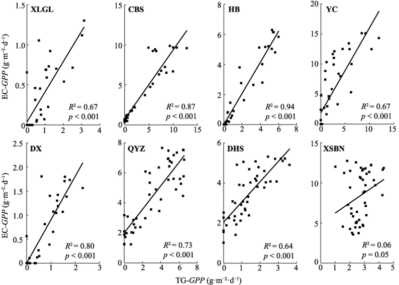
图4 TG模型模拟的2005年不同站点总初级生产力(TG-GPP)与同期涡度协相关总初级生产力(EC-GPP)之间的关系。CBS, 长白山温带红松阔叶林通量观测站; DHS, 鼎湖山南亚热带常绿阔叶林通量观测站; DX, 当雄高寒草甸碳通量观测站; HB, 海北高寒草甸生态系统通量观测站; QYZ, 千烟洲人工林通量观测站; XLGL, 锡林郭勒温性典型草原通量观测站; XSBN, 西双版纳热带雨林通量观测站; YC, 禹城暖温带半湿润旱作农田通量观测站。
Fig. 4 Relationships between the simulated gross primary production in 2005 by the TG model (TG-GPP) and the eddy covariance gross primary production (EC-GPP) for the corresponding time period for different study sites. CBS, Changbaishan Temperate Broad-leaved Korean Pine Forest Flux Observation Site; DHS, Dinghushan South Subtropical Evergreen Broadleaved Forest Flux Observation Site; DX, Damxung Alpine Meadow Flux Observation Site; HB, Haibei Alpine Meadow Ecosystem Flux Observation Site; QYZ, Qianyanzhou Planted Forest Flux Observation Site; XLGL, Xilingol Temperate Grassland Flux Observation Site; XSBN, Xishuangbanna Tropical Rainforest Flux Observation Site; YC, Yucheng Warmer Temperate Dry Farming Cropland Flux Observation Site.
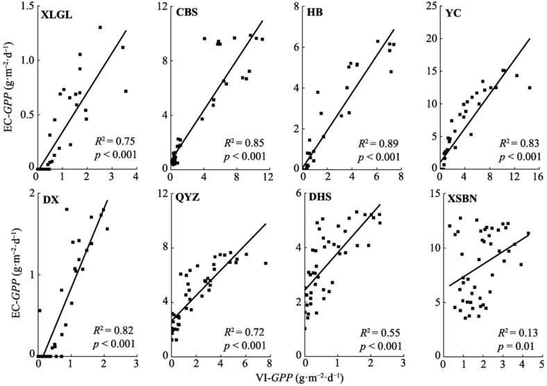
图5 VI模型模拟的2005年不同站点总初级生产力(VI-GPP)与涡度协相关总初级生产力(EC-GPP)之间的关系。CBS, 长白山温带红松阔叶林通量观测站; DHS, 鼎湖山南亚热带常绿阔叶林通量观测站; DX, 当雄高寒草甸碳通量观测站; HB, 海北高寒草甸生态系统通量观测站; QYZ, 千烟洲人工林通量观测站; XLGL, 锡林郭勒温性典型草原通量观测站; XSBN, 西双版纳热带雨林通量观测站; YC, 禹城暖温带半湿润旱作农田通量观测站。
Fig. 5 Relationships between the simulated gross primary production (VI-GPP) in 2005 by the VI model and the eddy covariance gross primary production (EC-GPP) for different study sites. CBS, Changbaishan Temperate Broad-leaved Korean Pine Forest Flux Observation Site; DHS, Dinghushan South Subtropical Evergreen Broadleaved Forest Flux Observation Site; DX, Damxung Alpine Meadow Flux Observation Site; HB, Haibei Alpine Meadow Ecosystem Flux Observation Site; QYZ, Qianyanzhou Planted Forest Flux Observation Site; XLGL, Xilingol Temperate Grassland Flux Observation Site; XSBN, Xishuangbanna Tropical Rainforest Flux Observation Site; YC, Yucheng Warmer Temperate Dry Farming Cropland Flux Observation Site.
| 站点 Site | 决定系数 Coefficient of determination (R2) | 相对误差 Relative error (RE) (%) | 均方根误差 Root mean square error (RMSE) (g·m-2·d-1) | |||
|---|---|---|---|---|---|---|
| TG | VI | TG | VI | TG | VI | |
| 锡林郭勒温性典型草原通量观测站 Xilingol Temperate Grassland Flux Observation Site | 0.67 | 0.75 | 126.79 | 196.62 | 0.62 | 0.77 |
| 长白山温带红松阔叶林通量观测站 Changbaishan Temperate Broad-Leaved Korean Pine Forest Flux Observation Site | 0.87 | 0.85 | -9.94 | -13.79 | 1.39 | 1.46 |
| 海北高寒草甸生态系统通量观测站 Haibei Alpine Meadow Ecosystem Flux Observation Site | 0.94 | 0.89 | -3.10 | 3.32 | 0.55 | 0.75 |
| 禹城暖温带半湿润旱作农田通量观测站 Yucheng Warmer Temperate Dry Farming Cropland Flux Observation Site | 0.67 | 0.83 | -55.41 | -39.42 | 4.30 | 3.15 |
| 当雄高寒草甸碳通量观测站 Damxung Alpine Meadow Flux Observation Site | 0.80 | 0.82 | 10.90 | 33.16 | 0.29 | 0.31 |
| 千烟洲人工林通量观测站 Qianyanzhou Planted Forest Flux Observation Site | 0.73 | 0.72 | -29.23 | -56.02 | 1.77 | 2.75 |
| 鼎湖山南亚热带常绿阔叶林通量观测站 Dinghushan South Subtropical Evergreen Broadleaved Forest Flux Observation Site | 0.64 | 0.55 | -60.08 | -79.09 | 2.19 | 2.84 |
| 西双版纳热带雨林通量观测站 Xishuangbanna Tropical Rainforest Flux Observation Site | 0.06 | 0.13 | -67.71 | -77.52 | 6.40 | 7.09 |
表2 TG和VI模型在模拟各站点2005年总初级生产力的表现
Table 2 Performance of the TG and VI models in simulating the gross primary production in 2005 for different study sites
| 站点 Site | 决定系数 Coefficient of determination (R2) | 相对误差 Relative error (RE) (%) | 均方根误差 Root mean square error (RMSE) (g·m-2·d-1) | |||
|---|---|---|---|---|---|---|
| TG | VI | TG | VI | TG | VI | |
| 锡林郭勒温性典型草原通量观测站 Xilingol Temperate Grassland Flux Observation Site | 0.67 | 0.75 | 126.79 | 196.62 | 0.62 | 0.77 |
| 长白山温带红松阔叶林通量观测站 Changbaishan Temperate Broad-Leaved Korean Pine Forest Flux Observation Site | 0.87 | 0.85 | -9.94 | -13.79 | 1.39 | 1.46 |
| 海北高寒草甸生态系统通量观测站 Haibei Alpine Meadow Ecosystem Flux Observation Site | 0.94 | 0.89 | -3.10 | 3.32 | 0.55 | 0.75 |
| 禹城暖温带半湿润旱作农田通量观测站 Yucheng Warmer Temperate Dry Farming Cropland Flux Observation Site | 0.67 | 0.83 | -55.41 | -39.42 | 4.30 | 3.15 |
| 当雄高寒草甸碳通量观测站 Damxung Alpine Meadow Flux Observation Site | 0.80 | 0.82 | 10.90 | 33.16 | 0.29 | 0.31 |
| 千烟洲人工林通量观测站 Qianyanzhou Planted Forest Flux Observation Site | 0.73 | 0.72 | -29.23 | -56.02 | 1.77 | 2.75 |
| 鼎湖山南亚热带常绿阔叶林通量观测站 Dinghushan South Subtropical Evergreen Broadleaved Forest Flux Observation Site | 0.64 | 0.55 | -60.08 | -79.09 | 2.19 | 2.84 |
| 西双版纳热带雨林通量观测站 Xishuangbanna Tropical Rainforest Flux Observation Site | 0.06 | 0.13 | -67.71 | -77.52 | 6.40 | 7.09 |
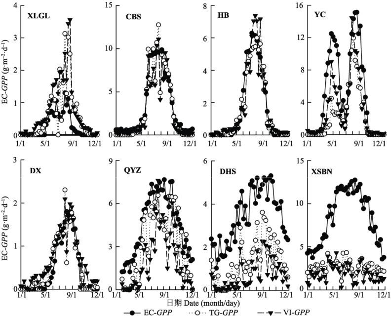
图6 不同站点涡度协相关总初级生产力(EC-GPP)与模型模拟总初级生产力(TG-GPP和VI-GPP)的时间序列图。CBS, 长白山温带红松阔叶林通量观测站; DHS, 鼎湖山南亚热带常绿阔叶林通量观测站; DX, 当雄高寒草甸碳通量观测站; HB, 海北高寒草甸生态系统通量观测站; QYZ, 千烟洲人工林通量观测站; XLGL, 锡林郭勒温性典型草原通量观测站; XSBN, 西双版纳热带雨林通量观测站; YC, 禹城暖温带半湿润旱作农田通量观测站。
Fig. 6 Time series of the eddy covariance gross primary production (EC-GPP) and the simulated gross primary production by the TG and VI models (TG-GPP and VI-GPP) for different study sites. CBS, Changbaishan Temperate Broad-leaved Korean Pine Forest Flux Observation Site; DHS, Dinghushan South Subtropical Evergreen Broadleaved Forest Flux Observation Site; DX, Damxung Alpine Meadow Flux Observation Site; HB, Haibei Alpine Meadow Ecosystem Flux Observation Site; QYZ, Qianyanzhou Planted Forest Flux Observation Site; XLGL, Xilingol Temperate Grassland Flux Observation Site; XSBN, Xishuangbanna Tropical Rainforest Flux Observation Site; YC, Yucheng Warmer Temperate Dry Farming Cropland Flux Observation Site.
| [1] | Beer C, Reichstein M, Tomelleri E, Ciais P, Jung M, Carvalhais N, Rödenbeck C, Arain MA, Baldocchi D, Bonan GB, Bondeau A, Cescatti A, Lasslop G, Lindroth A, Lomas M, Luyssaert S, Margolis H, Oleson KW, Roupsard O, Veenendaal E, Viovy N, Williams C, Woodward FI, Papale D (2010). Terrestrial gross carbon dioxide uptake: Global distribution and covariation with climate. Science, 329, 834-838. |
| [2] | Cao MK, Prinee SD, Li K (2003). Response of terrestrial carbon uptake to climate interannual variability in China. Global Change Biology, 9, 536-546. |
| [3] | Chen JQ, Yan MH, Wang SQ, Gao YN, Hang M, Wang JB, Xaio XM (2014). Estimation of gross primary production in Chinese terrestrial ecosystems by VPM model. Quaternary Sciences, 34, 732-742. (in Chinese with English abstract)[陈静清, 闫慧敏, 王绍强, 高艳妮, 黄玫, 王军邦, 肖向明 (2014). 中国陆地生态系统总初级生产力VPM遥感模型估算. 第四纪研究, 34, 732-742.] |
| [4] | Damm A, Elbers J, Erler E, Gioli B, Hamdi K, Hutjes R, Kosvancova M, Meroni M, Miglietta F, Moersch A (2010). Remote sensing of sun induced fluorescence to improve modeling of diurnal courses of gross primary production (GPP). Global Change Biology, 16, 171-186. |
| [5] | Drolet GG, Middleton EM, Huemmrich KF, Hall FG, Amiro BD, Barr AG, Black TA, McCaughey JH, Margolis HA (2008). Regional mapping of gross light-use efficiency using MODIS spectral indices. Remote Sensing of Environment, 112, 3064-3078. |
| [6] | Gao YN, Yu GR, Yan HM, Zhu XJ, Li SG, Wang QF, Zhang JH, Wang YF, Li YN, Zhao L, Shi PL (2014). A MODIS- based Photosynthetic Capacity Model to estimate gross primary production in Northern China and the Tibetan Plateau. Remote Sensing of Environment, 148, 108-118. |
| [7] | Gitelson AA, Gamon JA (2015). The need for a common basis for defining light-use efficiency: Implications for prod¬uctivity estimation. Remote Sensing of Environment, 156, 196-201. |
| [8] | Gitelson AA, Peng Y, Masek JG, Rundquist DC, Verma SS, Suyker A, Baker JM, Hatfield JL, Meyers T (2012). Remote estimation of crop gross primary production with Landsat data. Remote Sensing of Environment, 121, 404-414. |
| [9] | Granger RJ (2000). Satellite-derived estimates of evapotran¬spiration in the Gediz Basin. Journal of Hydrology, 229, 70-76. |
| [10] | Guanter L, Frankenberg C, Dudhia A, Lewis PE, Gomez-Dans J, Kuze A, Suto H, Grainger RG (2012). Retrieval and global assessment of terrestrial chlorophyll fluorescence from GOSAT space measurements. Remote Sensing of Environment, 121, 236-251. |
| [11] | Hao YB, Wang YF, Cui XY (2010). Drought stress reduces the carbon accumulation of the Leymus chinensis steppe in Inner Mongolia, China. Chinese Journal of Plant Ecology, 34, 898-906. (in Chinese with English abstract)[郝彦宾, 王艳芬, 崔骁勇 (2010). 干旱胁迫降低了内蒙古羊草草原的碳累积. 植物生态学报, 34, 898-906.] |
| [12] | Jiang Y, Zhang JH, Xu XD, Dong ZX (2013). A GPP assimilation model for the southeastern Tibetan Plateau based on CO2 eddy covariance flux tower and remote sensing data. International Journal of Applied Earth Observation and Geoinformation, 23, 213-225. |
| [13] | Le Quéré C, Raupauch MR, Canadell JG, Marland G (2009). Trends in the sources and sinks of carbon dioxide. Nature Geoscience, 2, 831-836. |
| [14] | Li XR, Zhu ZC, Zeng H, Piao SL (2016). Estimation of gross primary production in China (1982-2010) with multiple ecosystem models. Ecological Modelling, 324, 33-44. |
| [15] | Li ZQ, Yu GR, Xiao XM, Li YN, Zhao XQ, Ren CY, Zhang LM, Fu YL (2007). Modeling gross primary production of alpine ecosystems in the Tibetan Plateau using MODIS images and climate data. Remote Sensing of Environment, 107, 510-519. |
| [16] | Liu YC, Yu GR, Wang QF (2014b). How temperature, precipi¬tation and stand age control the biomass carbon density of global mature forests. Global Ecology and Biogeography, 23, 323-333. |
| [17] | Liu ZJ (2012). How Many Uncertainties Transferred from the Meteorological Data to the Terrestrial Carbon Cycle Modeling Based on CEVSA Model. Master degree dissertation, Shandong Normal University, Jinan. 35-44. (in Chinese with English abstract).[刘正佳 (2012). 气象数据的不确定性对CEVSA模型模拟结果的影响研究. 硕士学位论文, 山东师范大学, 济南. 35-44.] |
| [18] | Liu ZJ, Wang LC, Wang SS (2014a). Comparison of different GPP models in China using MODIS image and China FLUX data. Remote Sensing of Environment, 6, 10215-10231. |
| [19] | Lobell DB, Hicke JA, Asner GP, Field CB, Tucker CJ, Los SO (2002). Satellite estimates of productivity and light use efficiency in United States agriculture, 1982-1998. Global Change Biology, 8, 722-735. |
| [20] | Mekonnen AZ, Grant RF, Schwalm C (2016). Contrasting changes in gross primary productivity of different regions of North America as affected by warming in recent dec¬ades. Agricultural and Forest Meteorology, 218-219, 50-64. |
| [21] | Minunno F, Peltoniemi M, Launiainen S, Aurela M, Lindroth A, Lohila A, Mammarella L, Minkkinen K, Mäkelä A (2016). Calibration and validation of a semi-empirical flux ecosystem model for coniferous forests in the boreal region. Ecological Modelling, 341, 37-52. |
| [22] | Sánchez ML, Pardo N, Pérez IA, García MA (2015). GPP and maximum light use efficiency estimates using different approaches over a rotating biodiesel crop. Agricultural and Forest Meteorology, 214-215, 444-455. |
| [23] | Sims DA, Rahman AF, Cordova VD, El-Masri BZ, Baldocchi DD, Bolstad PV, Flanagan LB, Goldstein AH, Hollinger DY, Misson L, Monson RK, Oechel WC, Schmid HP, Wofsy SC, Xu LK (2008). A new model of gross primary productivity for North American ecosystems based solely on the enhanced vegetation index and land surface tem¬perature from MODIS. Remote Sensing of Environment, 112, 1633-1646. |
| [24] | Tian H, Melillo JM, Kieklighter DW, McGuire AD, Helfrich J (1999). The sensitivity of terrestrial carbon storage to history elimate variability and atmospheric CO2 in the United States. Tellus, 26, 414-452. |
| [25] | Verma M, Friedla MA, Lawc BE, Bonald D, Kielye G, Black TA, Wohlfahrtg G. Moors EJ, Montagnani L, Marcollal B, Toscanom P, Varlaginn A, Roupsardo O, Cescattiq A, Arainr MA, D’Odoricosa P (2015). Improving the performance of remote sensing models for capturing intra- and inter-annual variations in daily GPP: An analysis using global FLUXNET tower data. Agricultural and Forest Meteorology, 214-215, 416-429. |
| [26] | Wang HS, Jia GS, Feng JM, Zhao TB, Ma ZG (2010b). Mode¬ling gross primary production by integrating satellite data and coordinated flux measurements in arid and semi-arid China. Atmospheric and Oceanic Science Letters, 3, 7-13. |
| [27] | Wang HS, Jia GS, Fu CB, Feng JM, Zhao TB, Ma ZG (2010a). Deriving maximal light use efficiency from coordinated flux measurements and satellite data for regional gross primary production modeling. Remote Sensing of Env¬ir¬onment, 114, 2248-2258. |
| [28] | Wang XF, Ma MG, Li X, Song Y, Tan JL, Huang GH, Yu WP (2012). Comparison of remote sensing based GPP models at an alpine meadow site. Journal of Remote Sensing, 16, 751-763. (in Chinese with English abstract)[王旭峰, 马明国, 李新, 宋怡, 谭俊磊, 黄广辉, 于文凭 (2012). 遥感GPP模型在高寒草甸的应用比较. 遥感学报, 16, 751-763.] |
| [29] | Wu CY, Han XZ, Ni JS, Niu Z, Huang WJ (2010). Estimation of gross primary production in wheat from in situ measurements. International Journal of Applied Earth Observation and Geoinformation, 12, 183-189. |
| [30] | Wu WX, Wang SQ, Xiao XM, Yu GR, Fu YL, Hao YB (2008). Modeling gross primary production of a temperate grassland ecosystem in Inner Mongolia, China, using MODIS imagery and climate data. Science in China Series D—Earth Sciences, 38, 993-1004. (in Chinese with English abstract)[伍卫星, 王绍强, 肖向明, 于贵瑞, 伏玉玲, 郝彦宾 (2008). 利用MODIS影像和气候数据模拟中国内蒙古温带草原生态系统总初级生产力. 中国科学D辑: 地球科学, 38, 993-1004.] |
| [31] | Xiao XM, Zhang QY, Braswell B, Urbanski S, Boles S, Wofsy S, Moore III B, Ojima D (2004). Modeling gross primary production of temperate deciduous broadleaf forest using satellite images and climate data. Remote Sensing of Environment, 91, 256-270. |
| [32] | Yan M, Tian X, Li ZY, Chen E, Li CM, Fan WW (2016). A long-term simulation of forest carbon fluxes over the Qilian Mountains. International Journal of Applied Earth Observation and Geoinformation, 52, 515-526. |
| [33] | Yu GR, Sun XM (2006). Principle and Method of Terrestrial Ecosystem Flux Observation. Higher Education Press, Beijing. (in Chinese)[于贵瑞, 孙晓敏 (2006). 陆地生态系统通量观测的原理与方法. 高等教育出版社, 北京.] |
| [34] | Yu GR, Zhu XJ, Fu YL, He HL, Wang QF, Wen XF, Li XR, Zhang LM, Zhang L, Su W, Li SG, Sun XM, Zhang YP, Zhang JH, Yan JH, Wang HM, Zhou GS, Jia BR, Xiang WH, Li YN, Zhao L, Wang YF, Shi PL, Chen SP, Xin XP, Zhao FH, Wang YY, Tong CL (2012). Spatial patterns and climate drivers of carbon fluxes in terrestrial ecosystems of China. Global Change Biology, 19, 798-810. |
| [35] | Yu GY, Wen XF, Sun XM, Tanner BD, Lee XH, Chen JY (2006). Overview of ChinaFLUX and evaluation of its eddy covariance measurement. Agricultural and Forest Meteorology, 137, 125-137. |
| [36] | Yuan WP, Liu SG, Zhou GS, Zhou GY, Tieszen LL, Baldocchi D, Bernhofer C, Gholz H, Goldstein AH, Goulden ML, Hollinger DY, Hu YM, Law BE, Stoy PC, Vesala T, Wofsy SC (2007). Deriving a light use efficiency model from eddy covariance flux data for predicting daily gross primary production across biomes. Agricultural and Forest Meteorology, 143, 189-207. |
| [37] | Zhang WJ, Wang HM, Yang FT, Yi YH, Wen XF, Sun XM, Yu GR, Wang YD, Ning JC (2011). Underestimated effects of low temperature during early growing season on carbon sequestration of a subtropical coniferous plantation. Biogeosciences, 8, 1667-1678. |
| [38] | Zhou GS, Zhang XS (1995). A natural vegetation NPP model. Acta Phytoecologica Sinica,19, 193-200. (in Chinese with English abstract)[周广胜, 张新时 (1995). 自然植被净第一生产力模型初探. 植物生态学报, 19, 193-200.] |
| [39] | Zhou YR, Yu ZL, Zhao SD (2000). Carbon storage and budget of major Chinese forest types. Acta Phytoecologica Sinica, 24, 518-522. (in Chinese with English abstract)[周玉荣, 于振良, 赵士洞 (2000). 我国主要森林生态系统碳储存和碳平衡. 植物生态学报, 24, 518-522.] |
| [1] | 段俊丞, 王志勇, 高维聪, 张成凯, 高长宏, 刘晓彤, 李振今. 黄河三角洲湿地入侵物种互花米草时空演化与景观格局分析[J]. 植物生态学报, 2025, 49(6): 922-938. |
| [2] | 李琳, 黄佳芳, 丁中浩, 郭萍萍, 蔡芫镔, 李诗华, 李云琴, 罗敏. 淹水高度增加对短叶茳芏潮汐湿地净生态系统CO2交换量的影响[J]. 植物生态学报, 2025, 49(4): 526-539. |
| [3] | 王贝贝, 吴苏, 王苗苗, 胡锦涛. 日光诱导叶绿素荧光不同组分在作物总初级生产力估算中的贡献比例: 多时间尺度分析[J]. 植物生态学报, 2025, 49(4): 562-572. |
| [4] | 王音, 同小娟, 张劲松, 李俊, 孟平, 刘沛荣, 张静茹. 干旱对栓皮栎人工林碳水通量及其耦合的影响[J]. 植物生态学报, 2024, 48(9): 1157-1171. |
| [5] | 杨宇萌, 来全, 刘心怡. 气候变化和人类活动对内蒙古植被总初级生产力的定量影响[J]. 植物生态学报, 2024, 48(3): 306-316. |
| [6] | 郑亚纹, 樊海东, 刘立斌, 倪健. 基于高精度遥感影像和精细植被踏查的金华北山植被制图[J]. 植物生态学报, 2024, 48(11): 1471-1485. |
| [7] | 郝晴, 黄昌. 森林地上生物量遥感估算研究综述[J]. 植物生态学报, 2023, 47(10): 1356-1374. |
| [8] | 刘沛荣, 同小娟, 孟平, 张劲松, 张静茹, 于裴洋, 周宇. 散射辐射对中国东部典型人工林总初级生产力的影响[J]. 植物生态学报, 2022, 46(8): 904-918. |
| [9] | 丛楠, 张扬建, 朱军涛. 北半球中高纬度地区近30年植被春季物候温度敏感性[J]. 植物生态学报, 2022, 46(2): 125-135. |
| [10] | 原媛, 母艳梅, 邓钰洁, 李鑫豪, 姜晓燕, 高圣杰, 查天山, 贾昕. 植被覆盖度和物候变化对典型黑沙蒿灌丛生态系统总初级生产力的影响[J]. 植物生态学报, 2022, 46(2): 162-175. |
| [11] | 姜艳, 陈兴芳, 杨旭杰. 基于Landsat影像的武汉东湖30年来水生植物动态变化[J]. 植物生态学报, 2022, 46(12): 1551-1561. |
| [12] | 田佳玉, 王彬, 张志明, 林露湘. 光谱多样性在植物多样性监测与评估中的应用[J]. 植物生态学报, 2022, 46(10): 1129-1150. |
| [13] | 严正兵, 刘树文, 吴锦. 高光谱遥感技术在植物功能性状监测中的应用与展望[J]. 植物生态学报, 2022, 46(10): 1151-1166. |
| [14] | 薛金儒, 吕肖良. 黄土高原生态工程实施下基于日光诱导叶绿素荧光的植被恢复生产力效益评价[J]. 植物生态学报, 2022, 46(10): 1289-1304. |
| [15] | 陈哲, 汪浩, 王金洲, 石慧瑾, 刘慧颖, 贺金生. 基于物候相机归一化植被指数估算高寒草地植物地上生物量的季节动态[J]. 植物生态学报, 2021, 45(5): 487-495. |
| 阅读次数 | ||||||
|
全文 |
|
|||||
|
摘要 |
|
|||||
Copyright © 2026 版权所有 《植物生态学报》编辑部
地址: 北京香山南辛村20号, 邮编: 100093
Tel.: 010-62836134, 62836138; Fax: 010-82599431; E-mail: apes@ibcas.ac.cn, cjpe@ibcas.ac.cn
备案号: 京ICP备16067583号-19
![]()