
Chin J Plant Ecol ›› 2005, Vol. 29 ›› Issue (3): 436-443.DOI: 10.17521/cjpe.2005.0058
• Original article • Previous Articles Next Articles
LI Jun-Xiang( ), DA Liang-Jun, WANG Yu-Jie, SONG Yong-Chang
Received:2004-02-26
Accepted:2004-10-19
Online:2005-02-26
Published:2005-05-30
LI Jun-Xiang, DA Liang-Jun, WANG Yu-Jie, SONG Yong-Chang. VEGETATION CLASSIFICATION OF EAST CHINA USING MULTI-TEMPORAL NOAA-AVHRR DATA[J]. Chin J Plant Ecol, 2005, 29(3): 436-443.
Add to citation manager EndNote|Ris|BibTeX
URL: https://www.plant-ecology.com/EN/10.17521/cjpe.2005.0058
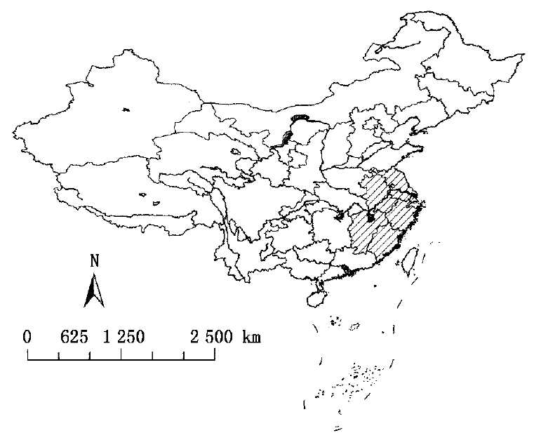
Fig.1 Location of the research area and its coverage
| 协相关特 征向量 Correlation eigenvector | 累积贡 献率 Cumulative contribution | 协方差特 征向量 Correlation eigenvector | 累积贡 献率 Cumulative contribution | |
|---|---|---|---|---|
| 主成分1 PC1 | 18.620 | 98.000 | 247 763.44 | 98.058 |
| 主成分2 PC2 | 0.151 | 98.795 | 1 952.86 | 98.831 |
| 主成分3 PC3 | 0.058 | 99.100 | 741.93 | 99.124 |
| 主成分4 PC4 | 0.034 | 99.279 | 434.73 | 99.296 |
| 主成分5 PC5 | 0.026 | 99.416 | 329.55 | 99.427 |
| 主成分6 PC6 | 0.020 | 99.521 | 243.69 | 99.523 |
| 主成分7 PC7 | 0.014 | 99.595 | 191.44 | 99.599 |
| 主成分8 PC8 | 0.012 | 99.658 | 151.07 | 99.659 |
| 主成分9 PC9 | 0.011 | 99.716 | 132.53 | 99.711 |
| 主成分10 PC10 | 0.009 | 99.763 | 123.20 | 99.760 |
| 主成分11 PC11 | 0.008 | 99.805 | 107.16 | 99.823 |
| 主成分12 PC12 | 0.007 | 99.842 | 91.18 | 99.839 |
| 主成分13 PC13 | 0.006 | 99.874 | 85.65 | 99.873 |
| 主成分14 PC14 | 0.005 | 99.900 | 69.38 | 99.900 |
| 主成分15 PC15 | 0.005 | 99.926 | 68.20 | 99.927 |
| 主成分16 PC16 | 0.004 | 99.947 | 57.38 | 99.950 |
| 主成分17 PC17 | 0.004 | 99.968 | 50.92 | 99.970 |
| 主成分18 PC18 | 0.003 | 99.984 | 38.43 | 99.985 |
| 主成分19 PC19 | 0.003 | 100.000 | 37.69 | 100.000 |
Table 1 Statistical traits of 19 maximum NDVI composite images after PCA processing
| 协相关特 征向量 Correlation eigenvector | 累积贡 献率 Cumulative contribution | 协方差特 征向量 Correlation eigenvector | 累积贡 献率 Cumulative contribution | |
|---|---|---|---|---|
| 主成分1 PC1 | 18.620 | 98.000 | 247 763.44 | 98.058 |
| 主成分2 PC2 | 0.151 | 98.795 | 1 952.86 | 98.831 |
| 主成分3 PC3 | 0.058 | 99.100 | 741.93 | 99.124 |
| 主成分4 PC4 | 0.034 | 99.279 | 434.73 | 99.296 |
| 主成分5 PC5 | 0.026 | 99.416 | 329.55 | 99.427 |
| 主成分6 PC6 | 0.020 | 99.521 | 243.69 | 99.523 |
| 主成分7 PC7 | 0.014 | 99.595 | 191.44 | 99.599 |
| 主成分8 PC8 | 0.012 | 99.658 | 151.07 | 99.659 |
| 主成分9 PC9 | 0.011 | 99.716 | 132.53 | 99.711 |
| 主成分10 PC10 | 0.009 | 99.763 | 123.20 | 99.760 |
| 主成分11 PC11 | 0.008 | 99.805 | 107.16 | 99.823 |
| 主成分12 PC12 | 0.007 | 99.842 | 91.18 | 99.839 |
| 主成分13 PC13 | 0.006 | 99.874 | 85.65 | 99.873 |
| 主成分14 PC14 | 0.005 | 99.900 | 69.38 | 99.900 |
| 主成分15 PC15 | 0.005 | 99.926 | 68.20 | 99.927 |
| 主成分16 PC16 | 0.004 | 99.947 | 57.38 | 99.950 |
| 主成分17 PC17 | 0.004 | 99.968 | 50.92 | 99.970 |
| 主成分18 PC18 | 0.003 | 99.984 | 38.43 | 99.985 |
| 主成分19 PC19 | 0.003 | 100.000 | 37.69 | 100.000 |
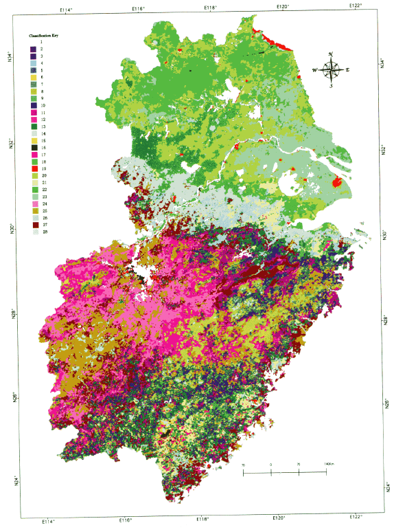
Fig.2 Map of vegetation classification in East China
| 针叶林* NLF | 常绿阔叶林 EBLF | 竹林 BF | 灌草丛 SHG | 水生植被 AV | 农业植被 CV | 落叶阔叶林 DLF | 常绿落叶阔 叶混交林 EDMF | ||||||
|---|---|---|---|---|---|---|---|---|---|---|---|---|---|
| 遥感分类 (3×3滤波) 斑块数 Patches identified (3×3 filtered) | 1 654 | 727 | 553 | 1 902 | 2 143 | 1 425 | - | - | |||||
| 中国植被数字化斑块数 Patches digitalized | 3 388 | 765 | 453 | 1 251 | 69 | 2 904 | 109 | 51 | |||||
| 重合的斑块数 Patches overlaid | 2 684 | 522 | 130 | 1 142 | 48 | 2 786 | - | - | |||||
| 分类精度 Accuracy (%) | 79.2 | 68.2 | 28.7 | 91.3 | 69.6 | 95.9 | |||||||
Table 2 Type accuracy assessment of the classified vegetation types in East China
| 针叶林* NLF | 常绿阔叶林 EBLF | 竹林 BF | 灌草丛 SHG | 水生植被 AV | 农业植被 CV | 落叶阔叶林 DLF | 常绿落叶阔 叶混交林 EDMF | ||||||
|---|---|---|---|---|---|---|---|---|---|---|---|---|---|
| 遥感分类 (3×3滤波) 斑块数 Patches identified (3×3 filtered) | 1 654 | 727 | 553 | 1 902 | 2 143 | 1 425 | - | - | |||||
| 中国植被数字化斑块数 Patches digitalized | 3 388 | 765 | 453 | 1 251 | 69 | 2 904 | 109 | 51 | |||||
| 重合的斑块数 Patches overlaid | 2 684 | 522 | 130 | 1 142 | 48 | 2 786 | - | - | |||||
| 分类精度 Accuracy (%) | 79.2 | 68.2 | 28.7 | 91.3 | 69.6 | 95.9 | |||||||
| 遥感分类类型 Identified vegetation type | 遥感分类面积 Area of identified types (km2) | 中国植被图类型 Digitalized vegetation types from Vegetation Atlas of China | 数字化中国植被 图类型面积 Area of digitalized types (km2) | 面积误差 Errors of area (km2) | 面积精度 Area accuracy (%) |
|---|---|---|---|---|---|
| 针叶林NLF | 150 292.0 | 针叶林NLF | 163 184.5 | -12 892.5 | 92.1 |
| 常绿阔叶林EBLF | 35 427.0 | 常绿阔叶林EBLF | 26 010.4 | 9 417.0 | 63.8 |
| 竹林BF | 16 243.0 | 竹林BF | 16 823.5 | -580.0 | 96.5 |
| 灌草丛SHG | 85 462.0 | 灌草丛SHG | 89 067.0 | -3 605.0 | 95.9 |
| 水生植被AV | 5 555.0 | 水生植被AV | 1 713.0 | 3 842.0 | 324.3 |
| 农业植被CV | 286 328.0 | 农业植被CV | 316 212.1 | -29 884.0 | 90.5 |
| 水面* Water | 55 005.0 | 水面* Water | 22 034.4 | 32 971.0 | 249.6 |
| 城区/裸地* Urban/bare soil | 4 288.0 | ||||
| 亚热带常绿落叶 阔叶混交林EDMF | 1108.9 | ||||
| 落叶阔叶林DBF | 4563.8 | ||||
| 合计 Total | 638 600.0 | 639 000.0 | -400.0 | 99.9 |
Table 3 Area accuracy assessment of the classified vegetation types in East China
| 遥感分类类型 Identified vegetation type | 遥感分类面积 Area of identified types (km2) | 中国植被图类型 Digitalized vegetation types from Vegetation Atlas of China | 数字化中国植被 图类型面积 Area of digitalized types (km2) | 面积误差 Errors of area (km2) | 面积精度 Area accuracy (%) |
|---|---|---|---|---|---|
| 针叶林NLF | 150 292.0 | 针叶林NLF | 163 184.5 | -12 892.5 | 92.1 |
| 常绿阔叶林EBLF | 35 427.0 | 常绿阔叶林EBLF | 26 010.4 | 9 417.0 | 63.8 |
| 竹林BF | 16 243.0 | 竹林BF | 16 823.5 | -580.0 | 96.5 |
| 灌草丛SHG | 85 462.0 | 灌草丛SHG | 89 067.0 | -3 605.0 | 95.9 |
| 水生植被AV | 5 555.0 | 水生植被AV | 1 713.0 | 3 842.0 | 324.3 |
| 农业植被CV | 286 328.0 | 农业植被CV | 316 212.1 | -29 884.0 | 90.5 |
| 水面* Water | 55 005.0 | 水面* Water | 22 034.4 | 32 971.0 | 249.6 |
| 城区/裸地* Urban/bare soil | 4 288.0 | ||||
| 亚热带常绿落叶 阔叶混交林EDMF | 1108.9 | ||||
| 落叶阔叶林DBF | 4563.8 | ||||
| 合计 Total | 638 600.0 | 639 000.0 | -400.0 | 99.9 |
| [1] | Achard F, Estreguil C (1995). ForestclassificationofSoutheastA siausingNOAAAVHRRdata. RemoteSensingofEnvironment, 54,198-208. |
| [2] | Achard F, Eva H, Mayaux P (2001). Tropicalforestmappingfromcoarsespatialresolutionsatellitedata:productionandaccuracyassessmentissues. InternationalJournalofRemoteSensing, 22,2741-2762. |
| [3] | Boyd DS, Ripple WJ (1997). Potentialvegetationindicesfordeter miningglobalforestcover. InternationalJournalofRemoteSens ing, 18,1395-1401. |
| [4] | Cihlar J, Ly H, Xiao Q (1996). LandcoverclassificationwithAVHRRmultichannelcompositioninNortherenvironments. RemoteSensingofEnvironment, 58,36-51. |
| [5] | DeFries R, Townshend JRG (1994). NDVI_derivedlandcoverclassificationsonaglobalscale. InternationalJournalofRemoteSensing, 15,3567-3586. |
| [6] | Editorial Board of The Forest of Jiangxi Province (江西森林编辑委员会) (1986). TheForestofJiangxiProvince (江西森林). JiangxiScience&TechnologyPress, Nanchang. (inChinese). |
| [7] | Editorial Board of Vegetation of Anhui Province (安徽植被编辑委员会) (1983). VegetationofAnhuiProvince (安徽植被). An huiScienceandTechnologyPress, Hefei. (inChinese). |
| [8] | Ehrlich D, Estes JE, Singh A (1994). ApplicationofNOAA_AVHRR 1kmdataforenvironmentalmonitoring. InternationalJournalofRemoteSensing, 15,145-161. |
| [9] | Eidenshink JC, Faundeen JL (1994). The1kmAVHRRgloballanddataset:firststagesinimplementation. InternationalJour nalofRemoteSensing, 15,3443-3462. |
| [10] | Goward SN, Huemmrich KF (1992). VegetationcanopyPARab sorbanceandthenormalizeddifferencevegetationindex:anas sessmentusingtheSAILmodel. RemoteSensingofEnvironment, 39,119-140. |
| [11] | Hou XY (侯学煜) (2000). VegetationAtlasofChina (中国植被图集). SciencePress, Beijing. (inChinese). |
| [12] | Li XB (李晓兵), Shi PJ (史培军) (1999). Researchonregula tionofNDVIChangeofChineseprimaryvegetationtypesbasedonNOAA/AVHRRdata. ActaBotanicaSinica (植物学报), 41,314-324. (inChinesewithEnglishabstract). |
| [13] | Lin P (林鹏) (1990). VegetationofFujianProvince (福建植被). FujianScience&TechnologyPress, Fuzhou. (inChinese). |
| [14] | Mayaux P, Gond V, Bartholome E (2000). Anear_realtimeforestcovermapofMadagascarderivedfromSPOT -4VEGETATION (VGT) data. InternationalJournalofRemoteSensing, 21,3139-3144. |
| [15] | Moody A, Strahler AH (1994). CharacteristicsofcompositeAVHRRdataandproblemsintheirclassification. InternationalJournalofRemoteSensing, 15,3473-3491. |
| [16] | Running SW, Hunt ER, Nemani R, Glassy J (1994). MODISLAI (leafareaindex) andFPAR (fractionphotosyntheticallyactivera diation). MODISalgorithmdocument.NASA, 19. |
| [17] | Scepan J (1999). Thematicvalidationofhigh_resolutiongloballand_coverdatasets. PhotogrammetricEngineering&RemoteSensing, 65,1051-1060. |
| [18] | Sellers PJ (1987). Canopyreflectance, photosynthesisandtranspi rationⅡ.Theroleofbiophysicsinthelinearityoftheirinterde pendence. RemoteSensingofEnvironment, 21,143-183. |
| [19] | Sellers PJ, Turker CJ, Collatz GJ, Los SO, Justice CO, Dazlich DA, Randall DA (1994). Aglobal1°by1°NDVIdatasetforclimatestudies.Part2, Thegenerationofglobalfieldsofterres trialbiophysicalparametersfromtheNDVI. InternationalJournalRemoteSensing, 15,3519-3545. |
| [20] | Sheng YW (盛永伟), Chen WY (陈维英), Xiao QG (肖乾广) GuoL (郭亮) (1995). Chinesevegetationclassificationwithme teorologicalsatellitevegetationindexdata. ChineseScienceBul letin (科学通报), 40,68-71. (inChinese). |
| [21] | Song YC (宋永昌) (1999). PerspectiveofthevegetationzonationofforestregionineasternChina. ActaBotanicaSinica (植物学报), 41,541-552. (inChinesewithEnglishabstract). |
| [22] | The Forest of Zhejiang Province Compilation Committee Edition (浙江森林编辑委员会) (1993). TheForestofZhejiangProvince (浙江森林). ChinaForestryPublishingHouse, Beijing. (inChinese). |
| [23] | Townshend JRG (1994). GlobaldatasetsforlandapplicationfromAdvancedVeryHighResolutionRadiometer:anintroduction. InternationalJournalofRemoteSensing, 15,3319-3332. |
| [24] | Townshend JRG, Justice CO, Skole D, Malingreau JP, Cihlar J, Teiliet P, Sadowski F, Ruttenberg S (1994). The1kmresolu tionglobaldataset:needsofTheInternationalGeosphereBio sphereProgramme. InternationalJournalofRemoteSensing, 15,3417-3441. |
| [25] |
Tucker CJ, Townshend JRG, Goff TE (1985a). Africaland_coverclassificationusingsatellitedata. Science, 227,369-375.
DOI URL |
| [26] | Tucker CJ, Vanpraet CL, Sharman MJ, vanIttersum G (1985b). SatelliteremotesensingoftotalherbaceousbiomassproductionintheSenegaleseSahel:1980-1984. RemoteSensingofEnviron ment, 17,233-249. |
| [27] | USGS (2004). Globallandcovercharacteristicsdataset. Http://edcdaac.usgs.gov/glcc/globdoc2_0.html.Cited21October2004. |
| [28] | Wu ZY (吴征镒) (1980). VegetationofChina (中国植被). SciencePress, Beijing. (inChinese). |
| [29] | Xiao X, Boles S, Liu J, Zhuang D, Liu M (2002). Characteriza tionofforesttypesinNortheasternChina, usingmulti_temporalSPOT_4VEGETATIONsensordata. RemoteSensingofEnviron ment, 82,335-348. |
| [30] | Zhu Z, Evans DL (1994). U.S.foresttypesandpredictedpercentforestcoverfromAVHRRdata. PhotogrammetricEngineeringandRemoteSensing, 60,525-531. |
| [1] | DONG Shao-Qiong, HOU Dong-Jie, QU Xiao-Yun, GUO Ke. A plot-based dataset of plant communities on the Qaidam Basin, China [J]. Chin J Plant Ecol, 2024, 48(4): 534-540. |
| [2] | CHEN Xue-Ping, ZHAO Xue-Yong, ZHANG Jing, WANG Rui-Xiong, LU Jian-Nan. Variation of NDVI spatio-temporal characteristics and its driving factors based on geodetector model in Horqin Sandy Land, China [J]. Chin J Plant Ecol, 2023, 47(8): 1082-1093. |
| [3] | MIAO Li-Juan, ZHANG Yu-Yang, CHUAI Xiao-Wei, BAO Gang, HE Yu, ZHU Jing-Wen. Effects of climatic factors and their time-lag on grassland NDVI in Asian drylands [J]. Chin J Plant Ecol, 2023, 47(10): 1375-1385. |
| [4] | HAO Qing, HUANG Chang. A review of forest aboveground biomass estimation based on remote sensing data [J]. Chin J Plant Ecol, 2023, 47(10): 1356-1374. |
| [5] | ZHU Yu-Ying, ZHANG Hua-Min, DING Ming-Jun, YU Zi-Ping. Changes of vegetation greenness and its response to drought-wet variation on the Qingzang Plateau [J]. Chin J Plant Ecol, 2023, 47(1): 51-64. |
| [6] | JIN Yi-Li, WANG Hao-Yan, WEI Lin-Feng, HOU Ying, HU Jing, WU Kai, XIA Hao-Jun, XIA Jie, ZHOU Bo-Rui, LI Kai, NI Jian. A plot-based dataset of plant community on the Qingzang Plateau [J]. Chin J Plant Ecol, 2022, 46(7): 846-854. |
| [7] | CHENG Si-Qi, JIANG Feng, JIN Guang-Ze. Leaf economics spectrum of broadleaved seedlings and its relationship with defense traits in a temperate forest [J]. Chin J Plant Ecol, 2022, 46(6): 678-686. |
| [8] | WANG Guo-Hong, GUO Ke, XIE Zong-Qiang, TANG Zhi-Yao, JIANG Yan-Ling, FANG Jing-Yun. Interpretations, supplements, and modifications of some protocols for compiling Vegegraphy of China [J]. Chin J Plant Ecol, 2022, 46(3): 368-372. |
| [9] | CONG Nan, ZHANG Yang-Jian, ZHU Jun-Tao. Temperature sensitivity of vegetation phenology in spring in mid- to high-latitude regions of Northern Hemisphere during the recent three decades [J]. Chin J Plant Ecol, 2022, 46(2): 125-135. |
| [10] | JIANG Yan, CHEN Xing-Fang, YANG Xu-Jie. Changes of aquatic plants in Donghu Lake of Wuhan based 1990-2020 Landsat images [J]. Chin J Plant Ecol, 2022, 46(12): 1551-1561. |
| [11] | YAN Zheng-Bing, LIU Shu-Wen, WU Jin. Hyperspectral remote sensing of plant functional traits: monitoring techniques and future advances [J]. Chin J Plant Ecol, 2022, 46(10): 1151-1166. |
| [12] | TIAN Jia-Yu, WANG Bin, ZHANG Zhi-Ming, LIN Lu-Xiang. Application of spectral diversity in plant diversity monitoring and assessment [J]. Chin J Plant Ecol, 2022, 46(10): 1129-1150. |
| [13] | Ning LIU, Shou-Zhang PENG, Yun-Ming CHEN. Temporal effects of climate factors on vegetation growth on the Qingzang Plateau, China [J]. Chin J Plant Ecol, 2022, 46(1): 18-26. |
| [14] | SUN Wen-Tai, MA Ming. Response of soil physical degradation and fine root growth on long-term film mulching in apple orchards on Loess Plateau [J]. Chin J Plant Ecol, 2021, 45(9): 972-986. |
| [15] | NI Ming, ZHANG Xi-Yue, JIANG Chao, WANG He-Song. Responses of vegetation to extreme climate events in southwestern China [J]. Chin J Plant Ecol, 2021, 45(6): 626-640. |
| Viewed | ||||||
|
Full text |
|
|||||
|
Abstract |
|
|||||
Copyright © 2026 Chinese Journal of Plant Ecology
Tel: 010-62836134, 62836138, E-mail: apes@ibcas.ac.cn, cjpe@ibcas.ac.cn
![]()