
Chin J Plant Ecol ›› 2006, Vol. 30 ›› Issue (2): 239-251.DOI: 10.17521/cjpe.2006.0033
• Original article • Previous Articles Next Articles
WU Xiao_Pu( ), TANG Zhi_Yao, CUI Hai_Ting, FANG Jing_Yun
Accepted:2005-06-17
Published:2006-03-30
WU Xiao_Pu, TANG Zhi_Yao, CUI Hai_Ting, FANG Jing_Yun. LAND COVER DYNAMICS OF DIFFERENT TOPOGRAPHIC CONDITIONS IN BEIJING[J]. Chin J Plant Ecol, 2006, 30(2): 239-251.
Add to citation manager EndNote|Ris|BibTeX
URL: https://www.plant-ecology.com/EN/10.17521/cjpe.2006.0033
| 时段 Time | 轨道号 Path code | |||||||||
|---|---|---|---|---|---|---|---|---|---|---|
| 1978_6_12 | MSS132_32, MSS131_32 | |||||||||
| 1984_10_2 | TM123_32 | |||||||||
| 1992_5_18 | TM123_32 | |||||||||
| 1996_5_29 | TM123_32, TM124_32 | |||||||||
| 2001_5_19 | ETM123_32 | |||||||||
Table 1 Remote sensing data used in this study
| 时段 Time | 轨道号 Path code | |||||||||
|---|---|---|---|---|---|---|---|---|---|---|
| 1978_6_12 | MSS132_32, MSS131_32 | |||||||||
| 1984_10_2 | TM123_32 | |||||||||
| 1992_5_18 | TM123_32 | |||||||||
| 1996_5_29 | TM123_32, TM124_32 | |||||||||
| 2001_5_19 | ETM123_32 | |||||||||
| 土地覆盖类型 Land cover types | 定义和主要组成 Definition& main components |
|---|---|
| 针叶林 Conifer forest | 包括暖温性针叶林(油松林、侧柏林)和寒温性针叶林(华北落叶松林) It includes warm_temperate conifer forests, such as Pinus tabulaeformis and Platycladus orientalis, and cold_temperate conifer forests, such as Larix principis_rupprechtii |
| 阔叶林 Broadleaf forest | 包括栎林、沟谷杂木林、椴树林、杨桦林和低海拔地区的人工经济林等 It includes oak forests, valley shaws, Tilia forests, Populus and Betula forests and plantations in low elevation area |
| 混交林 Mixed forest | 指针叶阔叶混交林。主要包括松栎混交林等 It indicates broadleaf and conifer mixed forest, most of which consists of Pinus and Quercus |
| 灌丛 Shrub | 各类森林在人类干扰下退化形成的次生植被类型,组成复杂。北京地区的主要类型有:荆条灌丛、绣线菊灌丛、平榛灌丛、山杏灌丛、二色胡枝子灌丛等 Secondary vegetation types with complex components, formed as human disturbance to primary forests. The main shrub types in Beijing include Vitex negundo var. heterophylla, Spiraea, Corylus heterophylla, Prunus armeniaca var. ansu and Lespedeza |
| 灌草丛 Grassland | 原生植被遭严重破坏后形成的不稳定植被类型,以旱中生草本植物为主,散生着灌木的植物群落。主要组成成分为白羊草、黄草等 An unstable vegetation type as primary vegetation was destroyed, mostly consisted with xerophilous herbages such as Bothriochloa ischaemum and Themeda japonica, some shrubs distribute in it occasionally |
| 亚高山草甸 Subalpine meadow | 分布在海拔1 800 m以上的坡顶,主要种类有苔草、黄花菜、地榆、拳参、金莲花等 Distribute at top of slopes above 1 800 m, mostly includes Carex, Hemerocallis minor, Sanguisorba officinalis, Polygonum bistorta and Trollius chinensis |
| 农业用地 Farmland | 包括平原地区大面积耕地、郊区果粮间作地等 Including large area cropland in plain area and intercrop land in suburb |
| 城镇用地 Built_up | 包括城市建成区、农村居民点和机场等大型建筑用地 Including built_up territory, rural residential area and large buildings such as airports |
| 水体 Water body | 包括水库、河流、湖泊和湿地 Including reservoirs, rivers, lakes and wetlands |
| 裸地 Bare land | 包括高反射率的无植被覆盖地和废弃建筑用地等 Including light reflectivity area such as no vegetation covered region and wasteland |
Table 2 Definitions and components of the ten land cover types used in the present study (Based on field investigation and vegetation map)
| 土地覆盖类型 Land cover types | 定义和主要组成 Definition& main components |
|---|---|
| 针叶林 Conifer forest | 包括暖温性针叶林(油松林、侧柏林)和寒温性针叶林(华北落叶松林) It includes warm_temperate conifer forests, such as Pinus tabulaeformis and Platycladus orientalis, and cold_temperate conifer forests, such as Larix principis_rupprechtii |
| 阔叶林 Broadleaf forest | 包括栎林、沟谷杂木林、椴树林、杨桦林和低海拔地区的人工经济林等 It includes oak forests, valley shaws, Tilia forests, Populus and Betula forests and plantations in low elevation area |
| 混交林 Mixed forest | 指针叶阔叶混交林。主要包括松栎混交林等 It indicates broadleaf and conifer mixed forest, most of which consists of Pinus and Quercus |
| 灌丛 Shrub | 各类森林在人类干扰下退化形成的次生植被类型,组成复杂。北京地区的主要类型有:荆条灌丛、绣线菊灌丛、平榛灌丛、山杏灌丛、二色胡枝子灌丛等 Secondary vegetation types with complex components, formed as human disturbance to primary forests. The main shrub types in Beijing include Vitex negundo var. heterophylla, Spiraea, Corylus heterophylla, Prunus armeniaca var. ansu and Lespedeza |
| 灌草丛 Grassland | 原生植被遭严重破坏后形成的不稳定植被类型,以旱中生草本植物为主,散生着灌木的植物群落。主要组成成分为白羊草、黄草等 An unstable vegetation type as primary vegetation was destroyed, mostly consisted with xerophilous herbages such as Bothriochloa ischaemum and Themeda japonica, some shrubs distribute in it occasionally |
| 亚高山草甸 Subalpine meadow | 分布在海拔1 800 m以上的坡顶,主要种类有苔草、黄花菜、地榆、拳参、金莲花等 Distribute at top of slopes above 1 800 m, mostly includes Carex, Hemerocallis minor, Sanguisorba officinalis, Polygonum bistorta and Trollius chinensis |
| 农业用地 Farmland | 包括平原地区大面积耕地、郊区果粮间作地等 Including large area cropland in plain area and intercrop land in suburb |
| 城镇用地 Built_up | 包括城市建成区、农村居民点和机场等大型建筑用地 Including built_up territory, rural residential area and large buildings such as airports |
| 水体 Water body | 包括水库、河流、湖泊和湿地 Including reservoirs, rivers, lakes and wetlands |
| 裸地 Bare land | 包括高反射率的无植被覆盖地和废弃建筑用地等 Including light reflectivity area such as no vegetation covered region and wasteland |
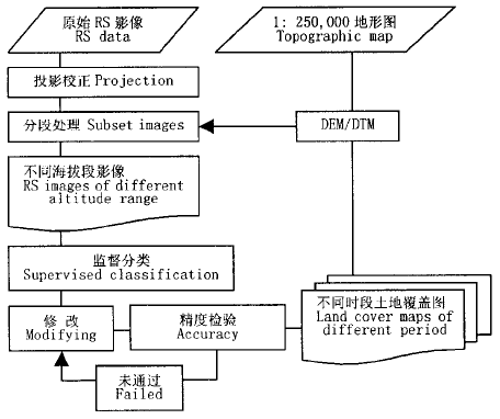
Fig.1 Flow chart of data analysis
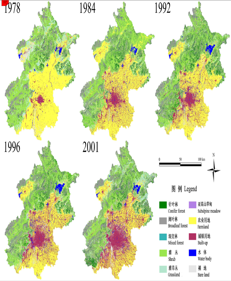
Fig.2 Distribution of land cover types in Beijing from 1978 to 2001, interpreted from RS images
| 土地覆盖类型 Land cover types | 1978 | 1984 | 1992 | 1996 | 2001 | 年平均改变速率 Transformation rate (hm2·a-1) |
|---|---|---|---|---|---|---|
| 面积 Area (hm2) | ||||||
| 林地Forest | 283 117 | 328 771 | 389 395 | 369 518 | 403 680 | 5 023 |
| 灌丛Shrub | 445 336 | 479 746 | 422 590 | 434 210 | 353 817 | -3 813 |
| 灌草丛Grassland | 173 607 | 70 088 | 80 926 | 86 676 | 132 938 | -1 695 |
| 亚高山草甸Subalpine meadow | 280 | 481 | 453 | 425 | 538 | 11 |
| 农业用地Farmland | 635 433 | 564 999 | 509 021 | 449 898 | 381 271 | -10 590 |
| 城镇用地Built_up | 42 116 | 136 483 | 147 100 | 199 549 | 264 229 | 9 255 |
| 水体Water body | 16 272 | 27 522 | 40 337 | 44 571 | 33 688 | 726 |
| 裸地Bare_land | 45 173 | 28 841 | 39 581 | 51 779 | 65 045 | 828 |
Table 3 Land cover change in Beijing Area from 1978 to 2001
| 土地覆盖类型 Land cover types | 1978 | 1984 | 1992 | 1996 | 2001 | 年平均改变速率 Transformation rate (hm2·a-1) |
|---|---|---|---|---|---|---|
| 面积 Area (hm2) | ||||||
| 林地Forest | 283 117 | 328 771 | 389 395 | 369 518 | 403 680 | 5 023 |
| 灌丛Shrub | 445 336 | 479 746 | 422 590 | 434 210 | 353 817 | -3 813 |
| 灌草丛Grassland | 173 607 | 70 088 | 80 926 | 86 676 | 132 938 | -1 695 |
| 亚高山草甸Subalpine meadow | 280 | 481 | 453 | 425 | 538 | 11 |
| 农业用地Farmland | 635 433 | 564 999 | 509 021 | 449 898 | 381 271 | -10 590 |
| 城镇用地Built_up | 42 116 | 136 483 | 147 100 | 199 549 | 264 229 | 9 255 |
| 水体Water body | 16 272 | 27 522 | 40 337 | 44 571 | 33 688 | 726 |
| 裸地Bare_land | 45 173 | 28 841 | 39 581 | 51 779 | 65 045 | 828 |
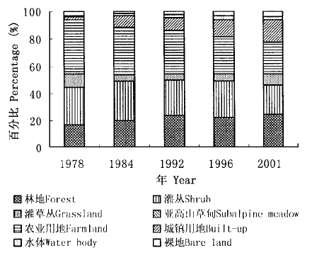
Fig.3 Land cover changes in Beijing Area from 1978 to 2001
| 土地覆盖类型 Land cover types | 林地 Forest | 灌丛 Shrub | 灌草丛 Grassland | 亚高山草甸 Subalpine meadow | 农业用地 Farmland | 城镇用地 Built_up | 水体 Water body | 裸地 Bare land |
|---|---|---|---|---|---|---|---|---|
| 1978 | 1984 | |||||||
| 林地Forest | 78.3 | 18.3 | 1.0 | 0.0 | 1.0 | 0.5 | 0.1 | 0.7 |
| 灌丛Shrub | 25.5 | 61.7 | 6.1 | 0.1 | 4.2 | 0.9 | 0.3 | 1.3 |
| 灌草丛Grassland | 7.4 | 47.4 | 15.6 | 0.0 | 24.9 | 2.7 | 0.9 | 1.1 |
| 亚高山草甸Subalpine meadow | 5.8 | 17.4 | 0.0 | 66.2 | 0.0 | 0.0 | 0.0 | 10.6 |
| 农业用地Farmland | 3.4 | 3.8 | 1.5 | 0.0 | 70.8 | 15.8 | 2.4 | 2.4 |
| 城镇用地Built_up | 1.2 | 6.1 | 1.7 | 0.0 | 31.7 | 51.3 | 5.5 | 2.4 |
| 水体Water body | 3.1 | 9.7 | 6.3 | 0.0 | 26.7 | 8.5 | 41.6 | 4.0 |
| 裸地Bare land | 1.4 | 3.3 | 5.2 | 0.4 | 75.3 | 8.0 | 1.0 | 5.4 |
| 1984 | 1992 | |||||||
| 林地Forest | 83.8 | 8.4 | 1.0 | 0.0 | 5.2 | 0.9 | 0.4 | 0.3 |
| 灌丛Shrub | 18.5 | 70.4 | 7.2 | 0.0 | 1.7 | 0.9 | 0.7 | 0.6 |
| 灌草丛Grassland | 7.2 | 37.8 | 36.1 | 0.0 | 11.8 | 2.4 | 2.5 | 2.1 |
| 亚高山草甸Subalpine meadow | 8.3 | 16.2 | 0.0 | 57.7 | 0.0 | 0.0 | 0.0 | 17.7 |
| 农业用地Farmland | 2.4 | 4.9 | 2.6 | 0.0 | 73.6 | 9.3 | 2.7 | 4.5 |
| 城镇用地Built_up | 3.2 | 1.7 | 1.4 | 0.0 | 31.4 | 56.6 | 3.0 | 2.8 |
| 水体Water body | 1.9 | 3.5 | 0.9 | 0.0 | 26.6 | 15.3 | 50.3 | 1.5 |
| 裸地Bare land | 13.0 | 10.2 | 5.7 | 0.0 | 34.2 | 13.5 | 2.4 | 21.1 |
| 1992 | 1996 | |||||||
| 林地Forest | 81.8 | 12.7 | 1.7 | 0.0 | 1.8 | 1.3 | 0.2 | 0.5 |
| 灌丛Shrub | 8.3 | 80.4 | 7.6 | 0.0 | 2.2 | 0.5 | 0.2 | 0.8 |
| 灌草丛Grassland | 3.7 | 39.5 | 40.6 | 0.0 | 6.7 | 4.0 | 0.4 | 4.9 |
| 亚高山草甸Subalpine Meadow | 6.3 | 10.8 | 0.0 | 76.3 | 0.0 | 0.0 | 0.0 | 6.7 |
| 农业用地Farmland | 1.5 | 1.0 | 1.4 | 0.0 | 77.1 | 13.2 | 2.1 | 3.7 |
| 城镇用地Built_up | 1.0 | 1.4 | 3.7 | 0.0 | 13.1 | 75.0 | 2.6 | 3.3 |
| 水体Water body | 1.2 | 1.6 | 1.7 | 0.0 | 13.2 | 12.7 | 67.7 | 1.8 |
| 裸地Bare land | 1.1 | 5.0 | 4.0 | 0.1 | 27.3 | 15.6 | 2.1 | 44.8 |
| 1996 | 2001 | |||||||
| 林地Forest | 82.8 | 10.9 | 2.2 | 0.0 | 2.1 | 1.4 | 0.2 | 0.5 |
| 灌丛Shrub | 16.3 | 66.6 | 14.1 | 0.0 | 1.7 | 0.3 | 0.1 | 1.0 |
| 灌草丛Grassland | 10.8 | 17.0 | 49.6 | 0.0 | 12.5 | 3.5 | 0.5 | 5.9 |
| 亚高山草甸Subalpine Meadow | 9.9 | 6.2 | 0.0 | 71.5 | 0.0 | 0.0 | 0.0 | 12.4 |
| 农业用地Farmland | 2.4 | 1.4 | 2.6 | 0.0 | 66.5 | 20.1 | 1.6 | 5.4 |
| 城镇用地Built_up | 1.8 | 0.6 | 1.1 | 0.0 | 15.5 | 71.9 | 2.2 | 6.8 |
| 水体Water body | 2.1 | 2.6 | 3.5 | 0.0 | 19.7 | 20.6 | 44.6 | 6.9 |
| 裸地Bare land | 4.7 | 2.9 | 10.6 | 0.8 | 31.5 | 23.1 | 1.3 | 25.0 |
Table 4 Percentage of land cover transformation in Beijing Area from1978 to 2001 (%)
| 土地覆盖类型 Land cover types | 林地 Forest | 灌丛 Shrub | 灌草丛 Grassland | 亚高山草甸 Subalpine meadow | 农业用地 Farmland | 城镇用地 Built_up | 水体 Water body | 裸地 Bare land |
|---|---|---|---|---|---|---|---|---|
| 1978 | 1984 | |||||||
| 林地Forest | 78.3 | 18.3 | 1.0 | 0.0 | 1.0 | 0.5 | 0.1 | 0.7 |
| 灌丛Shrub | 25.5 | 61.7 | 6.1 | 0.1 | 4.2 | 0.9 | 0.3 | 1.3 |
| 灌草丛Grassland | 7.4 | 47.4 | 15.6 | 0.0 | 24.9 | 2.7 | 0.9 | 1.1 |
| 亚高山草甸Subalpine meadow | 5.8 | 17.4 | 0.0 | 66.2 | 0.0 | 0.0 | 0.0 | 10.6 |
| 农业用地Farmland | 3.4 | 3.8 | 1.5 | 0.0 | 70.8 | 15.8 | 2.4 | 2.4 |
| 城镇用地Built_up | 1.2 | 6.1 | 1.7 | 0.0 | 31.7 | 51.3 | 5.5 | 2.4 |
| 水体Water body | 3.1 | 9.7 | 6.3 | 0.0 | 26.7 | 8.5 | 41.6 | 4.0 |
| 裸地Bare land | 1.4 | 3.3 | 5.2 | 0.4 | 75.3 | 8.0 | 1.0 | 5.4 |
| 1984 | 1992 | |||||||
| 林地Forest | 83.8 | 8.4 | 1.0 | 0.0 | 5.2 | 0.9 | 0.4 | 0.3 |
| 灌丛Shrub | 18.5 | 70.4 | 7.2 | 0.0 | 1.7 | 0.9 | 0.7 | 0.6 |
| 灌草丛Grassland | 7.2 | 37.8 | 36.1 | 0.0 | 11.8 | 2.4 | 2.5 | 2.1 |
| 亚高山草甸Subalpine meadow | 8.3 | 16.2 | 0.0 | 57.7 | 0.0 | 0.0 | 0.0 | 17.7 |
| 农业用地Farmland | 2.4 | 4.9 | 2.6 | 0.0 | 73.6 | 9.3 | 2.7 | 4.5 |
| 城镇用地Built_up | 3.2 | 1.7 | 1.4 | 0.0 | 31.4 | 56.6 | 3.0 | 2.8 |
| 水体Water body | 1.9 | 3.5 | 0.9 | 0.0 | 26.6 | 15.3 | 50.3 | 1.5 |
| 裸地Bare land | 13.0 | 10.2 | 5.7 | 0.0 | 34.2 | 13.5 | 2.4 | 21.1 |
| 1992 | 1996 | |||||||
| 林地Forest | 81.8 | 12.7 | 1.7 | 0.0 | 1.8 | 1.3 | 0.2 | 0.5 |
| 灌丛Shrub | 8.3 | 80.4 | 7.6 | 0.0 | 2.2 | 0.5 | 0.2 | 0.8 |
| 灌草丛Grassland | 3.7 | 39.5 | 40.6 | 0.0 | 6.7 | 4.0 | 0.4 | 4.9 |
| 亚高山草甸Subalpine Meadow | 6.3 | 10.8 | 0.0 | 76.3 | 0.0 | 0.0 | 0.0 | 6.7 |
| 农业用地Farmland | 1.5 | 1.0 | 1.4 | 0.0 | 77.1 | 13.2 | 2.1 | 3.7 |
| 城镇用地Built_up | 1.0 | 1.4 | 3.7 | 0.0 | 13.1 | 75.0 | 2.6 | 3.3 |
| 水体Water body | 1.2 | 1.6 | 1.7 | 0.0 | 13.2 | 12.7 | 67.7 | 1.8 |
| 裸地Bare land | 1.1 | 5.0 | 4.0 | 0.1 | 27.3 | 15.6 | 2.1 | 44.8 |
| 1996 | 2001 | |||||||
| 林地Forest | 82.8 | 10.9 | 2.2 | 0.0 | 2.1 | 1.4 | 0.2 | 0.5 |
| 灌丛Shrub | 16.3 | 66.6 | 14.1 | 0.0 | 1.7 | 0.3 | 0.1 | 1.0 |
| 灌草丛Grassland | 10.8 | 17.0 | 49.6 | 0.0 | 12.5 | 3.5 | 0.5 | 5.9 |
| 亚高山草甸Subalpine Meadow | 9.9 | 6.2 | 0.0 | 71.5 | 0.0 | 0.0 | 0.0 | 12.4 |
| 农业用地Farmland | 2.4 | 1.4 | 2.6 | 0.0 | 66.5 | 20.1 | 1.6 | 5.4 |
| 城镇用地Built_up | 1.8 | 0.6 | 1.1 | 0.0 | 15.5 | 71.9 | 2.2 | 6.8 |
| 水体Water body | 2.1 | 2.6 | 3.5 | 0.0 | 19.7 | 20.6 | 44.6 | 6.9 |
| 裸地Bare land | 4.7 | 2.9 | 10.6 | 0.8 | 31.5 | 23.1 | 1.3 | 25.0 |
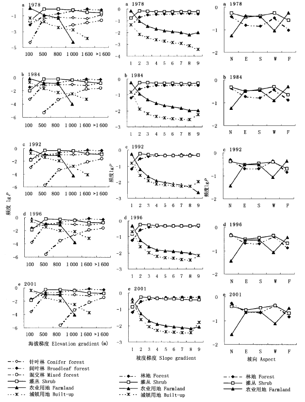
Fig.4 The frequency_area distributions of land cover in different topographic conditions 1:0~5° 2:5°~10° 3:10°~15° 4:15°~20° 5:20°~25° 6:25°~30° 7:30°~40° 8:40°~50° 9:>50°
| 海拔段 Altitude (m) | 总面积 Total area(hm2) | 土地覆盖改变类型 Change types | 变化率 Transformation percentage (%) | |||
|---|---|---|---|---|---|---|
| 1978~1984 | 1984~1992 | 1992~1996 | 1996~2001 | |||
| <100 | 637 131 | 林地Forest | 0.3 | 0.4 | 1.0 | 0.5 |
| 灌丛Shrub | 0.5 | 0.5 | 0.8 | 0.6 | ||
| 农业用地Farmland | 65.0 | 57.1 | 53.5 | 40.4 | ||
| 城镇用地Built_up | 3.2 | 11.2 | 15.3 | 20.5 | ||
| 农业用地转城镇用地Farmland to built_up | 15.5 | 6.6 | 10.3 | 13.5 | ||
| 城镇用地转农业用地Built_up to farmland | 1.5 | 6.5 | 2.6 | 4.3 | ||
| 100~500 | 440 168 | 林地Forest | 10.1 | 16.0 | 18.6 | 17.3 |
| 灌丛Shrub | 47.0 | 46.8 | 50.6 | 46.5 | ||
| 农业用地Farmland | 5.3 | 6.0 | 6.0 | 5.1 | ||
| 城镇用地Built_up | 0.6 | 0.6 | 1.3 | 1.4 | ||
| 灌丛转林地Shrub to forest | 7.4 | 7.7 | 1.9 | 8.3 | ||
| 灌丛转农业用地Shrub to farmland | 8.7 | 2.2 | 2.4 | 2.6 | ||
| 农业用地转灌丛Farmland to shrub | 5.9 | 6.5 | 1.6 | 2.5 | ||
| 500~1 000 | 463 940 | 林地Forest | 20.7 | 29.8 | 34.5 | 34.2 |
| 灌丛Shrub | 45.0 | 42.8 | 42.6 | 40.4 | ||
| 农业用地Farmland | 2.3 | 5.4 | 5.4 | 4.2 | ||
| 灌丛转林地Shrub to forest | 13.3 | 10.5 | 5.2 | 8.2 | ||
| >1 000 | 96 136 | 林地Forest | 63.1 | 65.0 | 72.6 | 74.4 |
| 灌丛Shrub | 10.8 | 12.5 | 10.9 | 11.8 | ||
| 林地转灌丛Forest to shrub | 7.6 | 2.9 | 5.7 | 5.1 | ||
| 灌丛转林地Shrub to forest | 11.6 | 11.1 | 5.8 | 5.4 |
Table 5 Land cover transformation in different elevation ranges in Beijing Area from 1978 to 2001
| 海拔段 Altitude (m) | 总面积 Total area(hm2) | 土地覆盖改变类型 Change types | 变化率 Transformation percentage (%) | |||
|---|---|---|---|---|---|---|
| 1978~1984 | 1984~1992 | 1992~1996 | 1996~2001 | |||
| <100 | 637 131 | 林地Forest | 0.3 | 0.4 | 1.0 | 0.5 |
| 灌丛Shrub | 0.5 | 0.5 | 0.8 | 0.6 | ||
| 农业用地Farmland | 65.0 | 57.1 | 53.5 | 40.4 | ||
| 城镇用地Built_up | 3.2 | 11.2 | 15.3 | 20.5 | ||
| 农业用地转城镇用地Farmland to built_up | 15.5 | 6.6 | 10.3 | 13.5 | ||
| 城镇用地转农业用地Built_up to farmland | 1.5 | 6.5 | 2.6 | 4.3 | ||
| 100~500 | 440 168 | 林地Forest | 10.1 | 16.0 | 18.6 | 17.3 |
| 灌丛Shrub | 47.0 | 46.8 | 50.6 | 46.5 | ||
| 农业用地Farmland | 5.3 | 6.0 | 6.0 | 5.1 | ||
| 城镇用地Built_up | 0.6 | 0.6 | 1.3 | 1.4 | ||
| 灌丛转林地Shrub to forest | 7.4 | 7.7 | 1.9 | 8.3 | ||
| 灌丛转农业用地Shrub to farmland | 8.7 | 2.2 | 2.4 | 2.6 | ||
| 农业用地转灌丛Farmland to shrub | 5.9 | 6.5 | 1.6 | 2.5 | ||
| 500~1 000 | 463 940 | 林地Forest | 20.7 | 29.8 | 34.5 | 34.2 |
| 灌丛Shrub | 45.0 | 42.8 | 42.6 | 40.4 | ||
| 农业用地Farmland | 2.3 | 5.4 | 5.4 | 4.2 | ||
| 灌丛转林地Shrub to forest | 13.3 | 10.5 | 5.2 | 8.2 | ||
| >1 000 | 96 136 | 林地Forest | 63.1 | 65.0 | 72.6 | 74.4 |
| 灌丛Shrub | 10.8 | 12.5 | 10.9 | 11.8 | ||
| 林地转灌丛Forest to shrub | 7.6 | 2.9 | 5.7 | 5.1 | ||
| 灌丛转林地Shrub to forest | 11.6 | 11.1 | 5.8 | 5.4 |
| 坡度 Slope | 总面积 Total area (hm2) | 土地覆盖改变类型 Change types | 变化率 Transformation percentage (%) | |||
|---|---|---|---|---|---|---|
| 1978~1984 | 1984~1992 | 1992~1996 | 1996~2001 | |||
| 0~5° | 897 107 | 林地Forest | 2.3 | 3.4 | 4.4 | 3.6 |
| 灌丛Shrub | 10.4 | 10.6 | 11.9 | 11.0 | ||
| 农业用地Farmland | 49.2 | 45.4 | 42.8 | 32.7 | ||
| 城镇用地Built_up | 2.3 | 8.4 | 11.9 | 15.5 | ||
| 其它Others | 9.8 | 10.2 | 12.2 | 14.8 | ||
| 灌丛转林地Shrub to forest | 1.6 | 1.5 | 0.6 | 1.4 | ||
| 农业用地转城镇用地Farmland to built_up | 11.1 | 5.5 | 7.4 | 10.0 | ||
| 城镇用地转农业用地Built_up to farmland | 1.4 | 4.7 | 2.1 | 3.4 | ||
| 5°~10° | 115 164 | 林地Forest | 14.7 | 20.4 | 24.2 | 22.9 |
| 灌丛Shrub | 49.7 | 48.9 | 51.2 | 49.7 | ||
| 农业用地Farmland | 3.4 | 3.6 | 3.8 | 2.6 | ||
| 林地转灌丛Forest to shrub | 5.1 | 3.0 | 4.9 | 4.8 | ||
| 灌丛转林地Shrub to forest | 9.6 | 8.5 | 4.0 | 7.2 | ||
| 灌丛转农业用地Shrub to farmland | 7.1 | 1.9 | 1.6 | 1.7 | ||
| 10°~20° | 330 572 | 林地Forest | 23.8 | 32.6 | 37.4 | 36.7 |
| 灌丛Shrub | 46.5 | 44.8 | 45.1 | 43.1 | ||
| 农业用地Farmland | 0.8 | 0.8 | 1.0 | 0.6 | ||
| 林地转灌丛Forest to shrub | 9.0 | 3.3 | 5.2 | 5.1 | ||
| 灌丛转林地Shrub to forest | 12.3 | 10.7 | 5.6 | 8.8 | ||
| >20° | 294 534 | 林地Forest | 28.9 | 37.9 | 43.3 | 42.5 |
| 灌丛Shrub | 43.4 | 41.0 | 41.1 | 36.9 | ||
| 农业用地Farmland | 0.2 | 0.3 | 0.5 | 0.3 | ||
| 林地转灌丛Forest to shrub | 9.8 | 3.7 | 6.5 | 5.5 | ||
| 灌丛转林地Shrub to forest | 12.9 | 11.8 | 4.4 | 10.6 |
Table 6 Land cover transformation along slope gradient in Beijing Area from 1978 to 2001
| 坡度 Slope | 总面积 Total area (hm2) | 土地覆盖改变类型 Change types | 变化率 Transformation percentage (%) | |||
|---|---|---|---|---|---|---|
| 1978~1984 | 1984~1992 | 1992~1996 | 1996~2001 | |||
| 0~5° | 897 107 | 林地Forest | 2.3 | 3.4 | 4.4 | 3.6 |
| 灌丛Shrub | 10.4 | 10.6 | 11.9 | 11.0 | ||
| 农业用地Farmland | 49.2 | 45.4 | 42.8 | 32.7 | ||
| 城镇用地Built_up | 2.3 | 8.4 | 11.9 | 15.5 | ||
| 其它Others | 9.8 | 10.2 | 12.2 | 14.8 | ||
| 灌丛转林地Shrub to forest | 1.6 | 1.5 | 0.6 | 1.4 | ||
| 农业用地转城镇用地Farmland to built_up | 11.1 | 5.5 | 7.4 | 10.0 | ||
| 城镇用地转农业用地Built_up to farmland | 1.4 | 4.7 | 2.1 | 3.4 | ||
| 5°~10° | 115 164 | 林地Forest | 14.7 | 20.4 | 24.2 | 22.9 |
| 灌丛Shrub | 49.7 | 48.9 | 51.2 | 49.7 | ||
| 农业用地Farmland | 3.4 | 3.6 | 3.8 | 2.6 | ||
| 林地转灌丛Forest to shrub | 5.1 | 3.0 | 4.9 | 4.8 | ||
| 灌丛转林地Shrub to forest | 9.6 | 8.5 | 4.0 | 7.2 | ||
| 灌丛转农业用地Shrub to farmland | 7.1 | 1.9 | 1.6 | 1.7 | ||
| 10°~20° | 330 572 | 林地Forest | 23.8 | 32.6 | 37.4 | 36.7 |
| 灌丛Shrub | 46.5 | 44.8 | 45.1 | 43.1 | ||
| 农业用地Farmland | 0.8 | 0.8 | 1.0 | 0.6 | ||
| 林地转灌丛Forest to shrub | 9.0 | 3.3 | 5.2 | 5.1 | ||
| 灌丛转林地Shrub to forest | 12.3 | 10.7 | 5.6 | 8.8 | ||
| >20° | 294 534 | 林地Forest | 28.9 | 37.9 | 43.3 | 42.5 |
| 灌丛Shrub | 43.4 | 41.0 | 41.1 | 36.9 | ||
| 农业用地Farmland | 0.2 | 0.3 | 0.5 | 0.3 | ||
| 林地转灌丛Forest to shrub | 9.8 | 3.7 | 6.5 | 5.5 | ||
| 灌丛转林地Shrub to forest | 12.9 | 11.8 | 4.4 | 10.6 |
| 坡向 Aspect | 总面积 Total area (hm2) | 土地覆盖改变类型 Change types | 变化率 Transformation percentage (%) | |||
|---|---|---|---|---|---|---|
| 1978~1984 | 1984~1992 | 1992~1996 | 1996~2001 | |||
| 北坡North | 108 398 | 林地Forest | 29.0 | 38.9 | 43.8 | 43.5 |
| 灌丛Shrub | 37.1 | 35.6 | 36.7 | 34.0 | ||
| 农业用地Farmland | 2.3 | 2.5 | 2.4 | 1.5 | ||
| 城镇用地Built_up | 0.1 | 0.3 | 0.3 | 0.2 | ||
| 其它Others | 1.7 | 2.4 | 2.2 | 2.1 | ||
| 林地转灌丛Forest to shrub | 8.8 | 3.9 | 6.4 | 4.9 | ||
| 灌丛转林地Shrub to forest | 13.8 | 11.2 | 4.1 | 8.9 | ||
| 东坡East | 410 363 | 林地Forest | 11.2 | 15.2 | 17.1 | 17.2 |
| 灌丛Shrub | 26.6 | 26.7 | 27.3 | 24.5 | ||
| 农业用地Farmland | 28.6 | 25.6 | 25.2 | 18.3 | ||
| 城镇用地Built_up | 0.9 | 3.4 | 1.3 | 1.5 | ||
| 其它Others | 5.3 | 6.6 | 6.7 | 7.8 | ||
| 林地转灌丛Forest to shrub | 4.0 | 2.1 | 2.9 | 2.6 | ||
| 灌丛转林地Shrub to forest | 6.1 | 4.3 | 2.7 | 5.3 | ||
| 南坡South | 366 444 | 林地Forest | 9.8 | 13.7 | 16.5 | 15.5 |
| 灌丛Shrub | 31.8 | 30.7 | 31.3 | 29.4 | ||
| 农业用地Farmland | 27.5 | 25.6 | 25.7 | 19.5 | ||
| 城镇用地Built_up | 1.2 | 2.4 | 0.9 | 1.7 | ||
| 其它Others | 5.1 | 6.7 | 6.4 | 7.4 | ||
| 林地转灌丛Forest to shrub | 4.4 | 1.7 | 3.3 | 3.4 | ||
| 灌丛转林地Shrub to forest | 5.5 | 5.5 | 2.7 | 4.9 | ||
| 西坡West | 208 626 | 林地Forest | 23.9 | 32.5 | 38.1 | 36.1 |
| 灌丛Shrub | 37.8 | 35.1 | 34.0 | 35.2 | ||
| 农业用地Farmland | 6.0 | 6.8 | 6.3 | 5.1 | ||
| 城镇用地Built_up | 0.1 | 0.3 | 0.3 | 0.5 | ||
| 其它Others | 2.2 | 2.9 | 3.5 | 3.6 | ||
| 林地转灌丛Forest to shrub | 9.5 | 2.7 | 6.4 | 5.3 | ||
| 灌丛转林地Shrub to forest | 11.5 | 11.9 | 3.3 | 7.6 | ||
| 平地Flat | 543 546 | 林地Forest | 6.8 | 9.4 | 11.1 | 10.3 |
| 灌丛Shrub | 16.1 | 15.8 | 17.3 | 16.3 | ||
| 农业用地Farmland | 39.6 | 36.7 | 33.0 | 25.8 | ||
| 城镇用地Built_up | 1.2 | 5.7 | 8.5 | 11.8 | ||
| 其它Others | 8.9 | 9.5 | 12.2 | 14.6 | ||
| 灌丛转林地Shrub to forest | 3.7 | 3.5 | 1.2 | 2.7 | ||
| 灌丛转农业用地Shrub to farmland | 5.0 | 1.3 | 1.1 | 1.4 | ||
| 农业用地转城镇用地Farmland to built_up | 8.4 | 4.7 | 6.8 | 7.1 | ||
| 城镇用地转农业用地Built_up to farmland | 1.2 | 3.6 | 1.8 | 3.2 |
Table 7 Land cover transformation in different aspects in Beijing Area from 1978 to 2001
| 坡向 Aspect | 总面积 Total area (hm2) | 土地覆盖改变类型 Change types | 变化率 Transformation percentage (%) | |||
|---|---|---|---|---|---|---|
| 1978~1984 | 1984~1992 | 1992~1996 | 1996~2001 | |||
| 北坡North | 108 398 | 林地Forest | 29.0 | 38.9 | 43.8 | 43.5 |
| 灌丛Shrub | 37.1 | 35.6 | 36.7 | 34.0 | ||
| 农业用地Farmland | 2.3 | 2.5 | 2.4 | 1.5 | ||
| 城镇用地Built_up | 0.1 | 0.3 | 0.3 | 0.2 | ||
| 其它Others | 1.7 | 2.4 | 2.2 | 2.1 | ||
| 林地转灌丛Forest to shrub | 8.8 | 3.9 | 6.4 | 4.9 | ||
| 灌丛转林地Shrub to forest | 13.8 | 11.2 | 4.1 | 8.9 | ||
| 东坡East | 410 363 | 林地Forest | 11.2 | 15.2 | 17.1 | 17.2 |
| 灌丛Shrub | 26.6 | 26.7 | 27.3 | 24.5 | ||
| 农业用地Farmland | 28.6 | 25.6 | 25.2 | 18.3 | ||
| 城镇用地Built_up | 0.9 | 3.4 | 1.3 | 1.5 | ||
| 其它Others | 5.3 | 6.6 | 6.7 | 7.8 | ||
| 林地转灌丛Forest to shrub | 4.0 | 2.1 | 2.9 | 2.6 | ||
| 灌丛转林地Shrub to forest | 6.1 | 4.3 | 2.7 | 5.3 | ||
| 南坡South | 366 444 | 林地Forest | 9.8 | 13.7 | 16.5 | 15.5 |
| 灌丛Shrub | 31.8 | 30.7 | 31.3 | 29.4 | ||
| 农业用地Farmland | 27.5 | 25.6 | 25.7 | 19.5 | ||
| 城镇用地Built_up | 1.2 | 2.4 | 0.9 | 1.7 | ||
| 其它Others | 5.1 | 6.7 | 6.4 | 7.4 | ||
| 林地转灌丛Forest to shrub | 4.4 | 1.7 | 3.3 | 3.4 | ||
| 灌丛转林地Shrub to forest | 5.5 | 5.5 | 2.7 | 4.9 | ||
| 西坡West | 208 626 | 林地Forest | 23.9 | 32.5 | 38.1 | 36.1 |
| 灌丛Shrub | 37.8 | 35.1 | 34.0 | 35.2 | ||
| 农业用地Farmland | 6.0 | 6.8 | 6.3 | 5.1 | ||
| 城镇用地Built_up | 0.1 | 0.3 | 0.3 | 0.5 | ||
| 其它Others | 2.2 | 2.9 | 3.5 | 3.6 | ||
| 林地转灌丛Forest to shrub | 9.5 | 2.7 | 6.4 | 5.3 | ||
| 灌丛转林地Shrub to forest | 11.5 | 11.9 | 3.3 | 7.6 | ||
| 平地Flat | 543 546 | 林地Forest | 6.8 | 9.4 | 11.1 | 10.3 |
| 灌丛Shrub | 16.1 | 15.8 | 17.3 | 16.3 | ||
| 农业用地Farmland | 39.6 | 36.7 | 33.0 | 25.8 | ||
| 城镇用地Built_up | 1.2 | 5.7 | 8.5 | 11.8 | ||
| 其它Others | 8.9 | 9.5 | 12.2 | 14.6 | ||
| 灌丛转林地Shrub to forest | 3.7 | 3.5 | 1.2 | 2.7 | ||
| 灌丛转农业用地Shrub to farmland | 5.0 | 1.3 | 1.1 | 1.4 | ||
| 农业用地转城镇用地Farmland to built_up | 8.4 | 4.7 | 6.8 | 7.1 | ||
| 城镇用地转农业用地Built_up to farmland | 1.2 | 3.6 | 1.8 | 3.2 |
| [1] | Beijing Municipal Agricultural Regionalization Committee Office (北京市农业区划委员会办公室)(1988). Beijing Agricultural Resources and Regionalization Atlas (北京农业资源与区划图集). Surveying and Mapping Press, Beijing,57-68. (in Chinese) |
| [2] | Chen LZ (陈灵芝), Bao XC (鲍显诚), Chen QL (陈清朗), Hu YH (胡肄慧), Kong FZ (孔繁志), Miao YG (缪有贵) (1990). Study on vegetation ecology in Tianjin and Beijing region. In: Institute of Botany and Institute of Zoology, Chinese Academy of Sciences (中国科学院植物研究所和动物研究所)eds. Study on the Biology and Ecology in Tianjin and Beijing Region (京津地区生物生态学研究), Surveying and Mapping Press, Beijing.1-14. (in Chinese) |
| [3] | Chen LZ (陈灵芝), Bao XC (鲍显诚), Li CG (李才贵) (1963). Characteristics of vegetation and their relations with forestry and side_production in mountain areas in Huairou, Beijing. Acta Phytoecologica et Geobotanica Sinica (植物生态学与地植物学丛刊), 3,75-96. (in Chinese with English abstract) |
| [4] | (Department of Biology, Beijing Normal University 北京师范大学生物系) (1958). Vegetation of Shangfangshan and its Utilization (上方山植被调查及其应用). Beijing Normal University Press, Beijing. (in Chinese) |
| [5] | Gu ZL (顾朝林) (1999). Study on phenomena and mechanism of land use/cover change in Beijing. Journal of Natural Resources (自然资源学报), 14,307-312. (in Chinese with English abstract) |
| [6] | He CY (何春阳), Shi PJ (史培军), Chen J (陈晋), Zhou YY (周宇宇) (2001). A study on land use/cover change in Beijing area. Geographical Research (地理研究), 20,679-687. (in Chinese with English abstract) |
| [7] | He CY (何春阳), Shi PJ (史培军), Chen J (陈晋), Xu XL (徐小黎) (2002). Process and mechanism of urbanization in Beijing area. Acta Geographica Sinica (地理学报), 57,363-371. (in Chinese with English abstract) |
| [8] | Huo YZ (霍亚贞), Yang ZM (杨作民), Meng DZ (孟德政) (1989). Physical Geography in Beijing (北京自然地理). The Publishing House of Beijing Normal College, Beijing. (in Chinese) |
| [9] | Imbernon J (1999). Pattern and development of land use changes in the Kenyan highlands since the 1950s. Agriculture, Ecosystems and Environment, 76,67-73. |
| [10] | Ispikoudis I, Lyrintzis G, Kyriakakis S (1993). Impact of human activities on Mediterranean landscape in Western Crete. Landscape and Urban Planning, 24,259-271. |
| [11] | Land Environmental Protection Department of Beijing Municipal Planning Committee (北京市计划委员会国土环保处) (1988). Land and Resources of Beijing (北京国土资源). Beijing Science and Technology Press, Beijing. (in Chinese) |
| [12] | Li JD (李继侗), Li B (李博), Yang C (杨澄) (1959). Vegetation of Beijing. Journal of Peking University (北京大学学报), 5,397-406. (in Chinese with English abstract) |
| [13] | Li XB (李秀彬) (1996). A review of the international researches on land use/land cover change. Acta Geographica Sinica (地理学报), 51,553-558. (in Chinese with English abstract) |
| [14] | National Bureau of Statistics of China (中华人民共和国国家统计局) (2001). 2001 (中国统计年鉴2001). Statistics Press, Beijing. |
| [15] | Qi Y, Henderson M, Xu M, Chen J, Shi PJ, He CY, William SG (2004). Evolving core_periphery interactions in a rapidly expanding urban landscape: the case of Beijing. Landscape Ecology, 19,375-388. |
| [16] | Ramankutty N, Foley JA (1999). Estimating historical changes in land_cover: North American croplands from 1850 to 1992. Global Ecology and Biogeography, 8,381-396. |
| [17] | Reid RS, Kruska RL, Muthui N, Taye A, Wotton S, Wilson CJ, Mulatu W (2000). Land_use and land_cover dynamics in response to changes in climatic, biological and socio_political forces: the case of southwestern Ethiopia. Landscape Ecology, 15,339-355. |
| [18] | Shi PJ (史培军), Gong P (宫鹏), Li XB (李晓兵) (2000). Methods and Practice of Land Use/Cover Change (土地利用/覆盖变化研究的方法与实践). Science Press, Beijing. (in Chinese) |
| [19] | Sun L (孙丽), Chen HW (陈焕伟), Pan JW (潘家文) (2004). Analysis of the land use spatiotemporal variation based on DEM, Beijing Yanqing Country as an example. Journal of Mountain Science (山地学报), 22,762-766. (in Chinese with English abstract) |
| [20] | Tian GJ (田光进), Zhang ZX (张增祥), Zhou QB (周全斌), Zhao XL (赵晓丽), Wang CY (王长有), Liu B (刘斌), Tan WB (谭文彬) (2003). Research on dynamic land_use pattern of Beijing by remote sensing and GIS. Remote Sense Information (遥感信息), 1,7-10. (in Chinese with English abstract) |
| [21] | Turner BL, Meyer WB (1991). Land use and land cover in global environmental change: considerations for study. International Social Science Journal, 130,669-680. |
| [22] | Turner BL, Moss RH, Skole D (1993). Relating land use and global land cover change: a proposal for an IGBP_IHDP core project. IGBP Report No.24, Stockholm. |
| [23] | Turner BL, Skole D, Sanderson S, Fisher G, Fresco L, Leemans R (1995). Land_use and land_cover change (LUCC): science/research plan. IGBP Report, No.35, HDP Report, No. 7, Stockholm. |
| [24] | Wang JA (王静爱), He CY (何春阳), Dong YC (董艳春), Gao L (高玲), Xu W (徐伟) (2002). Analysis of land use/cover driving forces in the urban fringe of Beijing city. Advance in Sciences (地球科学进展), 17,201-208. (in Chinese with English abstract) |
| [25] | Wu CJ (吴传钧), Guo HC (郭焕成) (1994). Chinese Land Use (中国土地利用). Science Press, Beijing. |
| [1] | Zhiyang Zhang Yinghui Zhao Zhen Zhen. Dynamic monitoring of carbon storage of the terrestrial ecosystem in Songhua River Basin from 1986 to 2022 [J]. Chin J Plant Ecol, 2024, 48(预发表): 0-0. |
| [2] | Yi-Heng Chen Yusupjan Rusul 吾斯曼 阿卜杜热合曼. Analysis of spatial and temporal variation in grassland vegetation cover in the Tianshan Mountains and the driving factors from 2001 to 2020 [J]. Chin J Plant Ecol, 2024, 48(5): 561-576. |
| [3] | ZHANG Ji-Shen, SHI Xin-Jie, LIU Yu-Nuo, WU Yang, PENG Shou-Zhang. Dynamics of ecosystem carbon storage of potential natural vegetation in China under climate change [J]. Chin J Plant Ecol, 2024, 48(4): 428-444. |
| [4] | DONG Shao-Qiong, HOU Dong-Jie, QU Xiao-Yun, GUO Ke. A plot-based dataset of plant communities on the Qaidam Basin, China [J]. Chin J Plant Ecol, 2024, 48(4): 534-540. |
| [5] | DENG Wen-Jie, WU Hua-Zheng, LI Tian-Xiang, ZHOU Li-Na, HU Ren-Yong, JIN Xin-Jie, ZHANG Yong-Pu, ZHANG Yong-Hua, LIU Jin-Liang. Main vegetation types and characteristics in Dongtou National Marine Park, Zhejiang, China [J]. Chin J Plant Ecol, 2024, 48(2): 254-268. |
| [6] | WU Han, BAI Jie, LI Jun-Li, Guli JIAPAER, BAO An-Ming. Study of spatio-temporal variation in fractional vegetation cover and its influencing factors in Xinjiang, China [J]. Chin J Plant Ecol, 2024, 48(1): 41-55. |
| [7] | CHEN Xue-Ping, ZHAO Xue-Yong, ZHANG Jing, WANG Rui-Xiong, LU Jian-Nan. Variation of NDVI spatio-temporal characteristics and its driving factors based on geodetector model in Horqin Sandy Land, China [J]. Chin J Plant Ecol, 2023, 47(8): 1082-1093. |
| [8] | LUO Na-Na, SHENG Mao-Yin, WANG Lin-Jiao, SHI Qing-Long, HE Yu. Effects of long-term vegetation restoration on soil active organic carbon fractions content and enzyme activities in karst rocky desertification ecosystem of southwest China [J]. Chin J Plant Ecol, 2023, 47(6): 867-881. |
| [9] | XU Gan-Jun, WU Sheng-Yi, LI Wei, ZHAO Xin-Sheng, NIE Lei-Chao, TANG Xi-Ying, ZHAI Xia-Jie. Estimation of carbon storage in Shaanxi Yellow River Wetland Provincial Nature Reserve [J]. Chin J Plant Ecol, 2023, 47(4): 469-478. |
| [10] | REN Pei-Xin, LI Peng, PENG Chang-Hui, ZHOU Xiao-Lu, YANG Ming-Xia. Temporal and spatial variation of vegetation photosynthetic phenology in Dongting Lake basin and its response to climate change [J]. Chin J Plant Ecol, 2023, 47(3): 319-330. |
| [11] | HE Jie, HE Liang, LÜ Du, CHENG Zhuo, XUE Fan, LIU Bao-Yuan, ZHANG Xiao-Ping. Spatiotemporal variation and its driving mechanism of photosynthetic vegetation in the Loess Plateau from 2001 to 2020 [J]. Chin J Plant Ecol, 2023, 47(3): 306-318. |
| [12] | TANG Lu-Yao, FANG Jing, QIAN Hai-Rong, ZHANG Bo-Na, SHANGGUAN Fang-Jing, YE Lin-Feng, LI Shu-Wen, TONG Jin-Lian, XIE Jiang-Bo. Variation and coordination in functional traits along the tree height of Taxodium distichum and Taxodium distichum var. imbricatum [J]. Chin J Plant Ecol, 2023, 47(11): 1561-1575. |
| [13] | MIAO Li-Juan, ZHANG Yu-Yang, CHUAI Xiao-Wei, BAO Gang, HE Yu, ZHU Jing-Wen. Effects of climatic factors and their time-lag on grassland NDVI in Asian drylands [J]. Chin J Plant Ecol, 2023, 47(10): 1375-1385. |
| [14] | HAO Qing, HUANG Chang. A review of forest aboveground biomass estimation based on remote sensing data [J]. Chin J Plant Ecol, 2023, 47(10): 1356-1374. |
| [15] | ZHOU Bo-Rui, LIAO Meng-Na, LI Kai, XU De-Yu, CHEN Hai-Yan, NI Jian, CAO Xian-Yong, KONG Zhao-Chen, XU Qing-Hai, ZHANG Yun, Ulrike HERZSCHUH, CAI Yong-Li, CHEN Bi-Shan, CHEN Jing-An, CHEN Ling-Kang, CHENG Bo, GAO Yang, $\boxed{\hbox{HUANG Ci-Xuan}}$ , HUANG Xiao-Zhong, LI Sheng-Feng, LI Wen-Yi, LIU Kam-Biu, LIU Guang-Xiu, LIU Ping-Mei, LIU Xing-Qi, MA Chun-Mei, SONG Chang-Qing, SUN Xiang-Jun, TANG Ling-Yu, WANG Man-Hua, WANG Yong-Bo, $\boxed{\hbox{XIA Yu-Mei}}$ , XU Jia-Sheng, YAN Shun, YANG Xiang-Dong, YAO Yi-Feng, YE Chuan-Yong, ZHANG Zhi-Yong, ZHAO Zeng-You, ZHENG Zhuo, ZHU Cheng. A fossil pollen dataset of China [J]. Chin J Plant Ecol, 2023, 47(10): 1453-1463. |
| Viewed | ||||||
|
Full text |
|
|||||
|
Abstract |
|
|||||
Copyright © 2022 Chinese Journal of Plant Ecology
Tel: 010-62836134, 62836138, E-mail: apes@ibcas.ac.cn, cjpe@ibcas.ac.cn