
Chin J Plant Ecol ›› 2020, Vol. 44 ›› Issue (4): 418-435.DOI: 10.17521/cjpe.2019.0206
Special Issue: 全球变化与生态系统; 生态学研究的方法和技术; 生态遥感及应用
• Reviews • Previous Articles Next Articles
GUO Qing-Hua*( ),HU Tian-Yu,MA Qin,XU Ke-Xin,YANG Qiu-Li,SUN Qian-Hui,LI Yu-Mei,SU Yan-Jun
Received:2019-08-06
Accepted:2019-10-14
Online:2020-04-20
Published:2020-02-24
Contact:
GUO Qing-Hua
Supported by:GUO Qing-Hua, HU Tian-Yu, MA Qin, XU Ke-Xin, YANG Qiu-Li, SUN Qian-Hui, LI Yu-Mei, SU Yan-Jun. Advances for the new remote sensing technology in ecosystem ecology research[J]. Chin J Plant Ecol, 2020, 44(4): 418-435.
Add to citation manager EndNote|Ris|BibTeX
URL: https://www.plant-ecology.com/EN/10.17521/cjpe.2019.0206
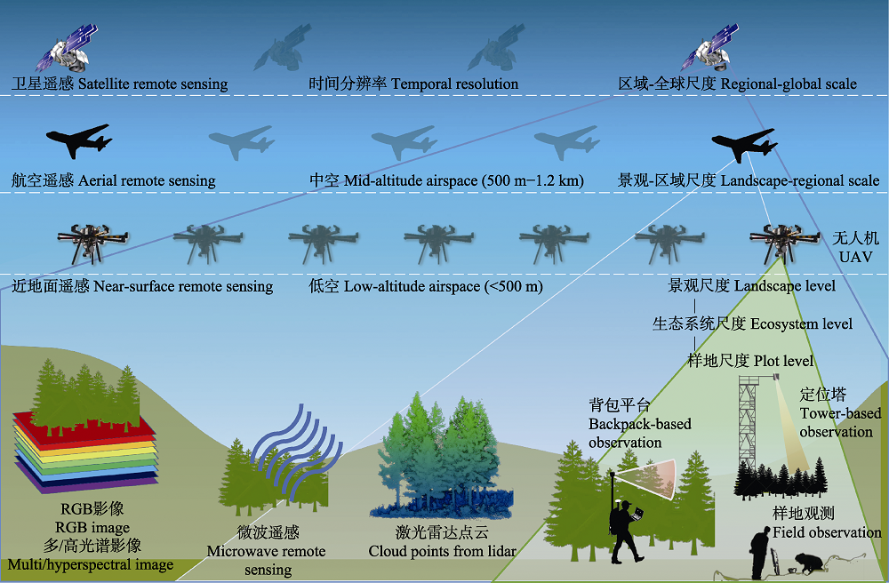
Fig. 1 Illustration of ecosystem monitoring with different sensors aboard various remote sensing platforms. UAV, unmanned aerial vehicle.
| 传感器 Sensor | 技术优势 Advantage | 主要应用领域 Application |
|---|---|---|
| RGB相机 RGB camera | 获取高空间分辨率的颜色和纹理信息 Capturing color and texture at high spatial resolution | 生态系统类型、植被状况、物候 Ecosystem type, vegetation monitoring, phenology |
| 多光谱/高光谱成像仪 Multi-spectral/ hyperspectral scanner | 获取数个或上百个波段的反射率信息 High spectral resolution; obtaining of several or hundreds spectral bands’ reflectance | 生态系统类型、物种分类、生化组分、植被健康、物候 Ecosystem type, species classification, biochemical composition, vegetation health, phenology |
| 微波雷达 Microwave radar | 全天候, 对林冠具有一定的穿透性, 能够获取部分地下信息 All-weather; limited penetrating vegetation canopy; capturing belowground information | 地形、蓄积量、树高、生物量 Topographic information, stand volume, tree height, biomass |
| 叶绿素荧光扫描仪 Solar-induced chlorophyll fluorescence scanner | 获取日光诱导的叶绿素荧光信息 Collecting solar-induced chlorophyll fluorescence | 初级生产力、物候、胁迫监测 Gross primary production, phenology, stress monitoring |
| 激光雷达扫描仪 Lidar scanner | 对林冠具有穿透性, 获取精细地形、丰富植被三维信息 Penetrating vegetation canopy; obtaining fine terrain and 3D vegetation information | 地形、胸径、树高、叶面积指数、生物量 Topographic information, diameter at breast height, tree height, leaf area index, biomass |
Table 1 Summary of advantages and applications of five major remote sensing sensors
| 传感器 Sensor | 技术优势 Advantage | 主要应用领域 Application |
|---|---|---|
| RGB相机 RGB camera | 获取高空间分辨率的颜色和纹理信息 Capturing color and texture at high spatial resolution | 生态系统类型、植被状况、物候 Ecosystem type, vegetation monitoring, phenology |
| 多光谱/高光谱成像仪 Multi-spectral/ hyperspectral scanner | 获取数个或上百个波段的反射率信息 High spectral resolution; obtaining of several or hundreds spectral bands’ reflectance | 生态系统类型、物种分类、生化组分、植被健康、物候 Ecosystem type, species classification, biochemical composition, vegetation health, phenology |
| 微波雷达 Microwave radar | 全天候, 对林冠具有一定的穿透性, 能够获取部分地下信息 All-weather; limited penetrating vegetation canopy; capturing belowground information | 地形、蓄积量、树高、生物量 Topographic information, stand volume, tree height, biomass |
| 叶绿素荧光扫描仪 Solar-induced chlorophyll fluorescence scanner | 获取日光诱导的叶绿素荧光信息 Collecting solar-induced chlorophyll fluorescence | 初级生产力、物候、胁迫监测 Gross primary production, phenology, stress monitoring |
| 激光雷达扫描仪 Lidar scanner | 对林冠具有穿透性, 获取精细地形、丰富植被三维信息 Penetrating vegetation canopy; obtaining fine terrain and 3D vegetation information | 地形、胸径、树高、叶面积指数、生物量 Topographic information, diameter at breast height, tree height, leaf area index, biomass |
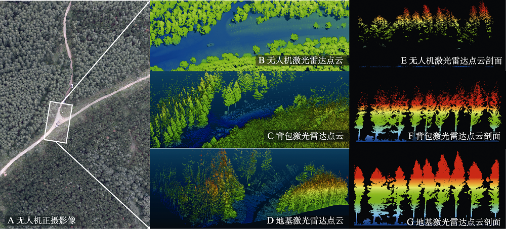
Fig. 2 Image and lidar data of ecosystem monitoring with near-surface remote sensing. A, Aerial image obtained by drone. B, Lidar data acquired by drone. C, Lidar data acquired by backpack. D, Lidar data acquired by terrestrial laser scanner. E, F, G, Profile of pervious three lidar data. The color of lidar data represent the information of elevation, blue is low and red is high.
| [1] |
Ayanu YZ, Conrad C, Nauss T, Wegmann M, Koellner T (2012). Quantifying and mapping ecosystem services supplies and demands: a review of remote sensing applications. Environmental Science & Technology, 46, 8529-8541.
URL PMID |
| [2] |
Baret F, Guyot G (1991). Potentials and limits of vegetation of vegetation indives for LAI and APAR assessment. Remote Sensing of Environment, 35(2-3), 161-173.
DOI URL |
| [3] | Bartholomé E, Belward AS (2005). GLC2000: a new approach to global land cover mapping from earth observation data. International Journal of Remote Sensing, 26, 1959-1977. |
| [4] |
Bergen KM, Goetz SJ, Dubayah RO, Henebry GM, Hunsaker CT, Imhoff ML, Nelson RF, Parker GG, Radeloff VC (2009). Remote sensing of vegetation 3-D structure for biodiversity and habitat: review and implications for lidar and radar spaceborne missions. Journal of Geophysical Research, 114, G00E06. DOI: 10.1029/2008JG000883.
URL PMID |
| [5] | Brede B, Lau A, Bartholomeus HM, Kooistra L (2017). Comparing RIEGL RiCOPTER UAV LiDAR derived canopy height and DBH with terrestrial LiDAR. Sensors, 17, 2371. DOI: 10.3390/s17102371. |
| [6] |
Butnor JR, Doolittle JA, Kress L, Cohen S, Johnsen KH (2001). Use of ground-penetrating radar to study tree roots in the southeastern United States. Tree Physiology, 21, 1269-1278.
DOI URL PMID |
| [7] | Carlson KM, Asner GP, Hughes RF, Ostertag R, Martin RE (2007). Hyperspectral remote sensing of canopy biodiversity in Hawaiian lowland rainforests. Ecosystems, 10, 536-549. |
| [8] | Carlson TN, Ripley DA (1997). On the relation between NDVI, fractional vegetation cover, and leaf area index. Remote Sensing of Environment, 62, 241-252. |
| [9] | Casas A, Riaño D, Ustin SL, Dennison P, Salas J (2014). Estimation of water-related biochemical and biophysical vegetation properties using multitemporal airborne hyperspectral data and its comparison to MODIS spectral response. Remote Sensing of Environment, 148, 28-41. |
| [10] |
Chambers JQ, Asner GP, Morton DC, Anderson LO, Saatchi SS, Espírito-Santo FDB, Palace M, Souza Jr C (2007). Regional ecosystem structure and function: ecological insights from remote sensing of tropical forests. Trends in Ecology & Evolution, 22, 414-423.
DOI URL PMID |
| [11] | Chapin III FS, Matson PA, Vitousek PM (2011). Principles of Terrestrial Ecosystem Ecology. Springer, New York. |
| [12] | Chave J (2013). The problem of pattern and scale in ecology: What have we learned in 20 years? Ecology Letters, 16(s1), 4-16. |
| [13] | Chen CD (1986). Aerospace monitoring of ecosystems—Introduction of the new soviet book. Remote Sensing Information, (1), 42. |
| [ 陈昌笃 (1986). 生态系统的航空航天监测——苏联新书介绍. 遥感信息, (1), 42.] | |
| [14] | Chen EX, Li ZY, Pang Y, Tian X (2007). Polarimetric synthetic aperture radar interferometry based mean tree height extraction technique. Scientia Silvae Sinicae, 43(4), 66-70. |
| [ 陈尔学, 李增元, 庞勇, 田昕 (2007). 基于极化合成孔径雷达干涉测量的平均树高提取技术. 林业科学, 43(4), 66-70.] | |
| [15] | Chen J, Chen J, Liao AP, Cao X, Chen LJ, Chen XH, He CY, Han G, Peng S, Lu M, Zhang WW, Tong XH, Mills J (2015). Global land cover mapping at 30 m resolution: a POK-based operational approach. ISPRS Journal of Photogrammetry and Remote Sensing, 103, 7-27. |
| [16] | Chen JM, Cihlar J (1996). Retrieving leaf area index of boreal conifer forests using Landsat TM images. Remote Sensing of Environment, 55 153-162. |
| [17] | Cheng YB, Zarco-Tejada PJ, Riaño D, Rueda CA, Ustin SL (2006). Estimating vegetation water content with hyperspectral data for different canopy scenarios: relationships between AVIRIS and MODIS indexes. Remote sensing of Environment, 105, 354-366. |
| [18] | Clark ML, Roberts DA, Ewel JJ, Clark DB (2011). Estimation of tropical rain forest aboveground biomass with small-footprint lidar and hyperspectral sensors. Remote Sensing of Environment, 115, 2931-2942. |
| [19] | Cochrane MA (2000). Using vegetation reflectance variability for species level classification of hyperspectral data. International Journal of Remote Sensing, 21, 2075-2087. |
| [20] | Cohen WB, Goward SN (2004). Landsatʼs role in ecological applications of remote sensing. BioScience, 54, 535-545. |
| [21] | Dassot M, Constant T, Fournier M (2011). The use of terrestrial LiDAR technology in forest science: application fields, benefits and challenges. Annals of Forest Science, 68, 959-974. |
| [22] | Datt B (1998). Remote sensing of chlorophyll a, chlorophyll b, chlorophyll a+b, and total carotenoid content in eucalyptus leaves. Remote sensing of Environment, 66, 111-121. |
| [23] | Daughtry C, Walthall C, Kim M, De Colstoun EB, McMurtrey III J (2000). Estimating corn leaf chlorophyll concentration from leaf and canopy reflectance. Remote Sensing of Environment, 74, 229-239. |
| [24] |
Davies AB, Asner GP (2014). Advances in animal ecology from 3D-LiDAR ecosystem mapping. Trends in Ecology & Evolution, 29, 681-691.
DOI URL PMID |
| [25] | Dong JW, Xiao XM, Chen BQ, Torbick N, Jin C, Zhang GL, Biradar C (2013). Mapping deciduous rubber plantations through integration of PALSAR and multi-temporal Landsat imagery. Remote Sensing of Environment, 134, 392-402. |
| [26] | Donoghue DNM, Watt PJ (2006). Using LiDAR to compare forest height estimates from IKONOS and Landsat ETM+ data in Sitka spruce plantation forests. International Journal of Remote Sensing, 27, 2161-2175. |
| [27] | Drake JB, Dubayah RO, Clark DB, Knox RG, Blair JB, Hofton MA, Chazdon RL, Weishampel JF, Prince SD (2002). Estimation of tropical forest structural characteristics using large-footprint lidar. Remote Sensing of Environment, 79, 305-319. |
| [28] | Dumbrell AJ, Kordas RL, Woodward G (2016). Large-scale ecology: model systems to global perspectives//Dumbrell AJ, Kordas RL, Woodward G. Advances in Ecological Research: Vol 55. Academic Press, Oxford. 2-663. |
| [29] |
Fang JY, Chen AP, Peng CH, Zhao SQ, Ci LJ (2001). Changes in forest biomass carbon storage in China between 1949 and 1998. Science, 292, 2320-2322.
URL PMID |
| [30] | Feret JB, Asner GP (2012). Semi-Supervised methods to identify individual crowns of lowland tropical canopy species using imaging spectroscopy and LiDAR. Remote Sensing, 4, 2457-2476. |
| [31] | Ferster CJ, Coops NC (2014). Assessing the quality of forest fuel loading data collected using public participation methods and smartphones. International Journal of Wildland Fire, 23, 585-590. |
| [32] | Ferster CJ, Coops NC (2016). Integrating volunteered smartphone data with multispectral remote sensing to estimate forest fuels. International Journal of Digital Earth, 9, 171-196. |
| [33] |
Frank D, Reichstein M, Bahn M, Thonicke K, Frank D, Mahecha MD, Smith P, van der Velde M, Vicca S, Babst F, Beer C, Buchmann N, Canadell JG, Ciais P, Cramer W, Ibrom A, Miglietta F, Poulter B, Rammig A, Seneviratne SI, Walz A, Wattenbach M, Zavala MA, Zscheischler J (2015). Effects of climate extremes on the terrestrial carbon cycle: concepts, processes and potential future impacts. Global Change Biology, 21, 2861-2880.
URL PMID |
| [34] | Frankenberg C, Fisher JB, Worden J, Badgley G, Saatchi SS, Lee JE, Toon GC, Butz A, Jung M, Kuze A, Yokota T (2011). New global observations of the terrestrial carbon cycle from GOSAT: patterns of plant fluorescence with gross primary productivity. Geophysical Research Letters, 38, L17706. DOI: 10.1029/2011GL048738. |
| [35] |
Frydenvang J, van Maarschalkerweerd M, Carstensen A, Mundus S, Schmidt SB, Pedas PR, Laursen KH, Schjoerring JK, Husted S (2015). Sensitive detection of phosphorus deficiency in plants using Chlorophyll a fluorescence. Plant Physiology, 169, 353-361.
DOI URL PMID |
| [36] | Fu BJ, Li SG, Yu XB, Yang P, Yu GR, Feng RG, Zhuang XL (2010). Chinese ecosystem research network: progress and perspectives. Ecological Complexity, 7, 225-233. |
| [37] | Gao BC (1996). NDWI—A normalized difference water index for remote sensing of vegetation liquid water from space. Remote Sensing of Environment, 58, 257-266. |
| [38] | Getzin S, Nuske RS, Wiegand K (2014). Using Unmanned Aerial Vehicles (UAV) to quantify spatial gap patterns in forests. Remote Sensing, 6, 6988-7004. |
| [39] | Getzin S, Wiegand K, Schoening I (2012). Assessing biodiversity in forests using very high-resolution images and unmanned aerial vehicles. Methods in Ecology and Evolution, 3, 397-404. |
| [40] | Gillanders SN, Coops NC, Wulder MA, Gergel SE, Nelson T (2008). Multitemporal remote sensing of landscape dynamics and pattern change: describing natural and anthropogenic trends. Progress in Physical Geography-Earth and Environment, 32, 503-528. |
| [41] | Goel NS (1988). Models of vegetation canopy reflectance and their use in estimation of biophysical parameters from reflectance data. Remote Sensing Reviews, 4(1), 1-212. |
| [42] | Gong P, Liu H, Zhang MN, Li CC, Wang J, Huang HB, Clinton N, Ji LY, Li WY, Bai YQ (2019). Stable classification with limited sample: transferring a 30-m resolution sample set collected in 2015 to mapping 10-m resolution global land cover in 2017. Science Bulletin, 64, 370-373. |
| [43] | Gorelick N, Hancher M, Dixon M, Ilyushchenko S, Thau D, Moore R (2017). Google Earth Engine: planetary-scale geospatial analysis for everyone. Remote Sensing of Environment, 202, 18-27. |
| [44] | Guanter L, Zhang Y, Jung M, Joiner J, Voigt M, Berry JA, Frankenberg C, Huete AR, Zarco-Tejada P, Lee J-E, Moran MS, Ponce-Campos G, Beer C, Camps-Valls G, Buchmann N, Gianelle D, Klumpp K, Cescatti A, Baker JM, Griffis TJ (2014). Global and time-resolved monitoring of crop photosynthesis with chlorophyll fluorescence. Proceedings of the National Academy of Sciences of the United States of America, 111, 1327-1333. |
| [45] | Guo QH, Liu J, Tao SL, Xue BL, Li L, Xu GC, Li WK, Wu FF, Li YM, Chen LH, Pang SX (2014). Perspectives and prospects of LiDAR in forest ecosystem monitoring and modeling. Chinese Science Bulletin, 59, 459-478. |
| [ 郭庆华, 刘瑾, 陶胜利, 薛宝林, 李乐, 徐光彩, 李文楷, 吴芳芳, 李玉美, 陈琳海, 庞树鑫 (2014). 激光雷达在森林生态系统监测模拟中的应用现状与展望. 科学通报, 59, 459-478.] | |
| [46] | Guo QH, Su YJ, Hu TY, Liu J (2018). LiDAR Principles, Processing and Applications in Forest Ecology. Higher Education Press, Beijing. |
| [ 郭庆华, 苏艳军, 胡天宇, 刘瑾 (2018). 激光雷达森林生态应用——理论、方法及实例. 高等教育出版社, 北京.] | |
| [47] | Guo QH, Su YJ, Hu TY, Zhao XQ, Wu FF, Li YM, Liu J, Chen LH, Xu GC, Lin GH, Zheng Y, Lin YQ, Mi XC, Fei L, Wang XG (2017). An integrated UAV-borne lidar system for 3D habitat mapping in three forest ecosystems across China. International Journal of Remote Sensing, 38, 2954-2972. |
| [48] | Guo QH, Wu FF, Hu TY, Chen LH, Liu J, Zhao XQ, Gao S, Pang SX (2016). Perspectives and prospects of unmanned aerial vehicle in remote sensing monitoring of biodiversity. Biodiversity Science, 24, 1267-1278. |
| [ 郭庆华, 吴芳芳, 胡天宇, 陈琳海, 刘瑾, 赵晓倩, 高上, 庞树鑫 (2016). 无人机在生物多样性遥感监测中的应用现状与展望. 生物多样性, 24, 1267-1278.] | |
| [49] | Hall FG, Shimabukuro YE, Huemmrich KF (1995). Remote-sensing of forest biophysical structure using mixture decomposition and geometric reflectance models. Ecological Applications, 5, 993-1013. |
| [50] | Hamylton SM (2017). Mapping coral reef environments: a review of historical methods, recent advances and future opportunities. Progress in Physical Geography, 41, 803-833. |
| [51] |
Hansen MC, Potapov PV, Moore R, Hancher M, Turubanova SA, Tyukavina A, Thau D, Stehman SV, Goetz SJ, Loveland TR, Kommareddy A, Egorov A, Chini L, Justice CO, Townshend JRG (2013). High-resolution global maps of 21st-century forest cover change. Science, 342, 850-853.
DOI URL PMID |
| [52] |
Hansen MC, Stehman SV, Potapov PV (2010). Quantification of global gross forest cover loss. Proceedings of the National Academy of Sciences of the United States of America, 107, 8650-8655.
URL PMID |
| [53] | Hernandez-Stefanoni JL (2006). The role of landscape patterns of habitat types on plant species diversity of a tropical forest in Mexico. Biodiversity and Conservation, 15, 1441-1457. |
| [54] |
Hilker T, Gitelson A, Coops NC, Hall FG, Black TA (2011). Tracking plant physiological properties from multi-angular tower-based remote sensing. Oecologia, 165, 865-876.
URL PMID |
| [55] |
Hobi ML, Dubinin M, Graham CH, Coops NC, Clayton MK, Pidgeon AM, Radeloff VC (2017). A comparison of Dynamic Habitat Indices derived from different MODIS products as predictors of avian species richness. Remote Sensing of Environment, 195, 142-152.
DOI URL |
| [56] | Houghton R (2005). Aboveground forest biomass and the global carbon balance. Global Change Biology, 11, 945-958. |
| [57] |
Hruska J, Čermák J, Šustek S (1999). Mapping tree root systems with ground-penetrating radar. Tree Physiology, 19, 125-130.
URL PMID |
| [58] | Hu T, Su Y, Xue B, Liu J, Zhao X, Fang J, Guo Q (2016). Mapping global forest aboveground biomass with spaceborne lidar, optical imagery, and forest inventory data. Remote Sensing, 8, 565. DOI: 10.3390/rs8070565. |
| [59] | Huang HB, Liu CX, Wang XY, Zhou XL, Gong P (2019). Integration of multi-resource remotely sensed data and allometric models for forest aboveground biomass estimation in China. Remote Sensing of Environment, 221, 225-234. |
| [60] | Husson E, Hagner O, Ecke F (2014). Unmanned aircraft systems help to map aquatic vegetation. Applied Vegetation Science, 17, 567-577. |
| [61] | Hyde P, Dubayah R, Walker W, Blair JB, Hofton M, Hunsaker C (2006). Mapping forest structure for wildlife habitat analysis using multi-sensor (LiDAR, SAR/InSAR, ETM plus, Quickbird) synergy. Remote Sensing of Environment, 102, 63-73. |
| [62] | Hyyppa J, Kelle O, Lehikoinen M, Inkinen M (2001). A segmentation-based method to retrieve stem volume estimates from 3-D tree height models produced by laser scanners. IEEE Transactions on Geoscience and Remote Sensing, 39, 969-975. |
| [63] | Jia WX, Liu M, Yang YH, He HL, Zhu XD, Yang F, Yin C, Xiang WM (2016). Estimation and uncertainty analyses of grassland biomass in Northern China: comparison of multiple remote sensing data sources and modeling approaches. Ecological Indicators, 60, 1031-1040. |
| [64] | Jung K, Kaiser S, Boehm S, Nieschulze J, Kalko EKV (2012). Moving in three dimensions: effects of structural complexity on occurrence and activity of insectivorous bats in managed forest stands. Journal of Applied Ecology, 49, 523-531. |
| [65] | Kampe T, Johnson B, Kuester M, Keller M (2010). NEON: the first continental-scale ecological observatory with airborne remote sensing of vegetation canopy biochemistry and structure. Journal of Applied Remote Sensing, 4, 043510. DOI: 10.1117/1.3361375. |
| [66] |
Kellndorfer J, Walker W, Pierce L, Dobson C, Fites JA, Hunsaker C, Vona J, Clutter M (2004). Vegetation height estimation from shuttle radar topography mission and national elevation datasets. Remote Sensing of Environment, 93, 339-358.
DOI URL |
| [67] | Kerr JT, Ostrovsky M (2003). From space to species: ecological applications for remote sensing. Trends in Ecology & Evolution, 18, 299-305. |
| [68] |
Knyazikhin Y, Schull MA, Stenberg P, Mõttus M, Rautiainen M, Yang Y, Marshak A, Latorre Carmona P, Kaufmann RK, Lewis P, Disney MI, Vanderbilt V, Davis AB, Baret F, Jacquemoud S, Lyapustin A, Myneni RB (2013). Hyperspectral remote sensing of foliar nitrogen content. Proceedings of the National Academy of Sciences of the United States of America, 110, E185. DOI: 10.1073/pnas.1210196109
DOI URL PMID |
| [69] | Koetz B, Morsdorf F, Sun G, Ranson KJ, Itten K, Allgower B (2006). Inversion of a lidar waveform model for forest biophysical parameter estimation. IEEE Geoscience and Remote Sensing Letters, 3, 49-53. |
| [70] | Kokaly RF, Asner GP, Ollinger SV, Martin ME, Wessman CA (2009). Characterizing canopy biochemistry from imaging spectroscopy and its application to ecosystem studies. Remote Sensing of Environment, 113, S78-S91. |
| [71] | Koukoulas S, Blackburn GA (2004). Quantifying the spatial properties of forest canopy gaps using LiDAR imagery and GIS. International Journal of Remote Sensing, 25, 3049-3071. |
| [72] | Landsberg JJ, Prince SD, Jarvis PG, McMurtrie RE, Luxmoore R, Medlyn BE (1997). Energy conversion and use in forests: an analysis of forest production in terms of radiation utilisation efficiency (ɛ)//Shimoda H, Gholz HL, Nakane K. The Use of Remote Sensing in the Modeling of Forest Productivity. Springer, Dordrecht. 273-298. |
| [73] | Lausch A, Bannehr L, Beckmann M, Boehm C, Feilhauer H, Hacker JM, Heurichr M, Jung A, Klenke R, Neumann C, Pause M, Rocchini D, Schaepman ME, Schmidtlein S, Schulz K, Selsam P, Settele J, Skidmore AK, Cord AF (2016). Linking Earth Observation and taxonomic, structural and functional biodiversity: local to ecosystem perspectives. Ecological Indicators, 70, 317-339. |
| [74] | Lefsky MA (2010). A global forest canopy height map from the Moderate Resolution Imaging Spectroradiometer and the Geoscience Laser Altimeter System. Geophysical Research Letters, 37, L15401. DOI: 10.1029/2010GL043622. |
| [75] |
Lefsky MA, Cohen WB, Parker GG, Harding DJ (2002). Lidar remote sensing for ecosystem studies: lidar, an emerging remote sensing technology that directly measures the three-dimensional distribution of plant canopies, can accurately estimate vegetation structural attributes and should be of particular interest to forest, landscape, and global ecologists. BioScience, 52, 19-30.
DOI URL |
| [76] |
Lefsky MA, Harding D, Cohen WB, Parker G, Shugart HH (1999). Surface lidar remote sensing of basal area and biomass in deciduous forests of eastern Maryland, USA. Remote Sensing of Environment, 67, 83-98.
DOI URL |
| [77] |
Lesak AA, Radeloff VC, Hawbaker TJ, Pidgeon AM, Gobakken T, Contrucci K (2011). Modeling forest songbird species richness using LiDAR-derived measures of forest structure. Remote Sensing of Environment, 115, 2823-2835.
DOI URL |
| [78] |
Letoan T, Beaudoin A, Riom J, Guyon D (1992). Relating forest biomass to SAR data. IEEE Transactions on Geoscience and Remote Sensing, 30, 403-411.
DOI URL |
| [79] |
Levin SA (1992). The problem of pattern and scale in ecology. Ecology, 73, 1943-1967.
DOI URL |
| [80] |
Li DR, Li M (2014). Research advance and application prospect of unmanned aerial vehicle remote sensing system. Geomatics and Information Science of Wuhan University, 39, 505-513.
DOI URL |
|
[ 李德仁, 李明 (2014). 无人机遥感系统的研究进展与应用前景. 武汉大学学报(信息科学版), 39, 505-513.]
DOI URL |
|
| [81] |
Li WK, Guo QH, Tao SL, Su YJ (2018a). VBRT: a novel voxel-based radiative transfer model for heterogeneous three-dimensional forest scenes. Remote Sensing of Environment, 206, 318-335.
DOI URL |
| [82] |
Li X, Xiao JF, He BB (2018b). Chlorophyll fluorescence observed by OCO-2 is strongly related to gross primary productivity estimated from flux towers in temperate forests. Remote Sensing of Environment, 204, 659-671.
DOI URL |
| [83] |
Li YM, Guo QH, Su YJ, Tao SL, Zhao KG, Xu GC (2017). Retrieving the gap fraction, element clumping index, and leaf area index of individual trees using single-scan data from a terrestrial laser scanner. ISPRS Journal of Photogrammetry and Remote Sensing, 130, 308-316.
DOI URL |
| [84] |
Li YM, Guo QH, Tao SL, Zheng G, Zhao KG, Xue BL, Su YJ (2016). Derivation, validation, and sensitivity analysis of terrestrial laser scanning-based leaf area index. Canadian Journal of Remote Sensing, 42, 719-729.
DOI URL |
| [85] | Liao XH, Zhou CH, SU FZ, Lu HY, Yue HY, Gou JP (2016). The mass innovation era of UAV remote sensing. Journal of Geo-information Science, 18, 1439-1448. |
| [ 廖小罕, 周成虎, 苏奋振, 卢海英, 岳焕印, 缑吉平 (2016). 无人机遥感众创时代. 地球信息科学学报, 18, 1439-1448.] | |
| [86] | Lim K, Treitz P, Wulder M, St-Onge B, Flood M (2003). LiDAR remote sensing of forest structure. Progress in Physical Geography, 27(1), 88-106. |
| [87] |
Loveland TR, Belward A (1997). The IGBP-DIS global 1 km land cover data set, DISCover: first results. International Journal of Remote Sensing, 18, 3289-3295.
DOI URL |
| [88] |
Luyssaert S, Schulze ED, Boerner A, Knohl A, Hessenmoeller D, Law BE, Ciais P, Grace J (2008). Old-growth forests as global carbon sinks. Nature, 455, 213-215.
DOI URL PMID |
| [89] | Ma KP (1993). On the concept of biodiversity. Chinese Biodiversity, 1, 20-22. |
| [ 马克平 (1993). 试论生物多样性的概念. 生物多样性, 1, 20-22.] | |
| [90] | McCombs JW, Roberts SD, Evans DL (2003). Influence of fusing lidar and multispectral imagery on remotely sensed estimates of stand density and mean tree height in a managed loblolly pine plantation. Forest Science, 49, 457-466. |
| [91] |
Montesano PM, Neigh C, Sun G, Duncanson L, van den Hoek J, Ranson KJ (2017). The use of sun elevation angle for stereogrammetric boreal forest height in open canopies. Remote Sensing of Environment, 196, 76-88.
URL PMID |
| [92] |
Morsdorf F, Koetz B, Meier E, Itten KI, Allgoewer B (2006). Estimation of LAI and fractional cover from small footprint airborne laser scanning data based on gap fraction. Remote Sensing of Environment, 104, 50-61.
DOI URL |
| [93] |
Morsdorf F, Nichol C, Malthus T, Woodhouse IH (2009). Assessing forest structural and physiological information content of multi-spectral LiDAR waveforms by radiative transfer modelling. Remote Sensing of Environment, 113, 2152-2163.
DOI URL |
| [94] |
Mutanga O, Skidmore AK (2004). Integrating imaging spectroscopy and neural networks to map grass quality in the Kruger National Park, South Africa. Remote Sensing of Environment, 90, 104-115.
DOI URL |
| [95] |
Naesset E, Okland T (2002). Estimating tree height and tree crown properties using airborne scanning laser in a boreal nature reserve. Remote Sensing of Environment, 79, 105-115.
DOI URL |
| [96] |
Nagendra H, Rocchini D, Ghate R, Sharma B, Pareeth S (2010). Assessing plant diversity in a dry tropical forest: comparing the utility of Landsat and IKONOS satellite images. Remote Sensing, 2, 478-496.
DOI URL |
| [97] |
Naidoo L, Cho MA, Mathieu R, Asner G (2012). Classification of savanna tree species, in the Greater Kruger national park region, by integrating hyperspectral and LiDAR data in a random forest data mining environment. ISPRS Journal of Photogrammetry and Remote Sensing, 69, 167-179.
DOI URL |
| [98] |
Nilsson M (1996). Estimation of tree heights and stand volume using an airborne lidar system. Remote Sensing of Environment, 56, 1-7.
DOI URL |
| [99] |
Nuijten RJG, Coops NC, Goodbody TRH, Pelletier G (2019). Examining the multi-seasonal consistency of individual tree segmentation on deciduous stands using digital aerial photogrammetry (DAP) and unmanned aerial systems (UAS). Remote Sensing, 11, 739. DOI: 10.3390/rs11070739.
DOI URL |
| [100] | Odum EP, Barrett GW (1971). Fundamentals of Ecology. Saunders, Philadelphia. |
| [101] |
Otero V, van de Kerchove R, Satyanarayana B, Martinez- Espinosa C, Bin Fisol MA, Bin Ibrahim MR, Sulong I, Mohd-Lokman H, Lucas R, Dandouh-Guebas F (2018). Managing mangrove forests from the sky: forest inventory using field data and unmanned aerial vehicle (UAV) imagery in the Matang mangrove forest Reserve, peninsular Malaysia. Forest Ecology and Management, 411, 35-45.
DOI URL |
| [102] |
Palminteri S, Powell GVN, Asner GP, Peres CA (2012). LiDAR measurements of canopy structure predict spatial distribution of a tropical mature forest primate. Remote Sensing of Environment, 127, 98-105.
DOI URL |
| [103] |
Pang Y, Li ZY, Chen EX, Sun GQ (2005). Lidar remote sensing technology and its application in forestry. Scientia Silvae Sinicae, 41(3), 129-136.
DOI URL |
|
[ 庞勇, 李增元, 陈尔学, 孙国清 (2005). 激光雷达技术及其在林业上的应用. 林业科学, 41(3), 129-136]
DOI URL |
|
| [104] |
Pettorelli N, Laurance WF, O’Brien TG, Wegmann M, Nagendra H, Turner W (2014). Satellite remote sensing for applied ecologists: opportunities and challenges. Journal of Applied Ecology, 51, 839-848.
DOI URL |
| [105] |
Pettorelli N, Vik JO, Mysterud A, Gaillard J-M, Tucker CJ, Stenseth NC (2005). Using the satellite-derived NDVI to assess ecological responses to environmental change. Trends in Ecology & Evolution, 20, 503-510.
DOI URL PMID |
| [106] | Piao SL, Fang JY, Zhou LM, Tan K, Tao S (2007). Changes in biomass carbon stocks in China’s grasslands between 1982 and 1999. Global Biogeochemical Cycles, 21, GB2002. DOI: 10.1029/2005GB002634. |
| [107] |
Piao SL, Liu Q, Chen AP, Janssens IA, Fu YS, Dai JH, Liu LL, Lian X, Shen MG, Zhu XL (2019). Plant phenology and global climate change: current progresses and challenges. Global Change Biology, 25, 1922-1940.
DOI URL PMID |
| [108] |
Pimm SL, Alibhai S, Bergl R, Dehgan A, Giri C, Jewell Z, Joppa L, Kays R, Loarie S (2015). Emerging technologies to conserve biodiversity. Trends in Ecology & Evolution, 30, 685-696.
DOI URL PMID |
| [109] |
Popescu SC, Wynne RH, Nelson RF (2003). Measuring individual tree crown diameter with lidar and assessing its influence on estimating forest volume and biomass. Canadian Journal of Remote Sensing, 29, 564-577.
DOI URL |
| [110] |
Potter CS, Randerson JT, Field CB, Matson PA, Vitousek PM, Mooney HA, Klooster SA (1993). Terrestrial ecosystem production—A process model-based on global satellite and surface data. Global Biogeochemical Cycles, 7, 811-841.
DOI URL |
| [111] |
Qi J, Chehbouni A, Huete AR, Kerr YH, Sorooshian S (1994). A modified soil adjusted vegetation index. Remote Sensing of Environment, 48, 119-126.
DOI URL |
| [112] |
Ramoelo A, Skidmore AK, Schlerf M, Heitkönig IMA, Mathieu R, Cho MA (2013). Savanna grass nitrogen to phosphorous ratio estimation using field spectroscopy and the potential for estimation with imaging spectroscopy. International Journal of Applied Earth Observation and Geoinformation, 23, 334-343.
DOI URL |
| [113] |
Ranson KJ, Sun GQ (1994). Mapping biomass of a northern forest using multifrequency SAR data. IEEE Transactions on Geoscience and Remote Sensing, 32, 388-396.
DOI URL |
| [114] |
Richardson AD, Braswell BH, Hollinger DY, Jenkins JP, Ollinger SV (2009a). Near-surface remote sensing of spatial and temporal variation in canopy phenology. Ecological Applications, 19, 1417-1428.
DOI URL PMID |
| [115] |
Richardson JJ, Moskal LM, Kim S-H (2009b). Modeling approaches to estimate effective leaf area index from aerial discrete-return LiDAR. Agricultural and Forest Meteorology, 149, 1152-1160.
DOI URL |
| [116] | Running SW, Thornton PE, Nemani R, Glassy JM (2000). Global terrestrial gross and net primary productivity from the earth observing system//Sala OE, Jackson RB, Mooney HA, Howarth RW. Methods in Ecosystem Science. Springer, New York. 44-57. |
| [117] |
Saatchi SS, Harris NL, Brown S, Lefsky M, Mitchard ETA, Salas W, Zutta BR, Buermann W, Lewis SL, Hagen S, Petrova S, White L, Silman M, Morel A (2011). Benchmark map of forest carbon stocks in tropical regions across three continents. Proceedings of the National Academy of Sciences of the United States of America, 108, 9899-9904.
URL PMID |
| [118] | Sankey TT, Bond P (2011). LiDAR-based classification of sagebrush community types. Rangeland Ecology & Management, 64, 92-98. |
| [119] | Simard M, Pinto N, Fisher JB, Baccini A (2011). Mapping forest canopy height globally with spaceborne lidar. Journal of Geophysical Research, 116, G04021. DOI: 10.1029/2011jg001708. |
| [120] |
Skidmore AK, Ferwerda JG, Mutanga O, van Wieren SE, Peel M, Grant RC, Prins HHT, Balcik FB, Venus V (2010). Forage quality of savannas—Simultaneously mapping foliar protein and polyphenols for trees and grass using hyperspectral imagery. Remote Sensing of Environment, 114, 64-72.
DOI URL |
| [121] | Smith AMS, Falkowski MJ, Hudak AT, Evans JS, Robinson AP, Steele CM (2009). A cross-comparison of field, spectral, and lidar estimates of forest canopy cover. Canadian Journal of Remote Sensing, 35, 447-459. |
| [122] | Spanner MA, Pierce LL, Peterson DL, Running SW (1990). Remote-sensing of temperate coniferous forest leaf-area index—The influence of canopy closure, understory vegetation and background reflectance. International Journal of Remote Sensing, 11, 95-111. |
| [123] | Srinivasan S, Popescu SC, Eriksson M, Sheridan RD, Ku N-W (2015). Terrestrial laser scanning as an effective tool to retrieve tree level height, crown width, and stem diameter. Remote Sensing, 7, 1877-1896. |
| [124] | Stagakis S, Markos N, Sykioti O, Kyparissis A (2010). Monitoring canopy biophysical and biochemical parameters in ecosystem scale using satellite hyperspectral imagery: an application on a Phlomis fruticosa Mediterranean ecosystem using multiangular CHRIS/PROBA observations. Remote Sensing of Environment, 114, 977-994. |
| [125] |
St-Louis V, Pidgeon AM, Radeloff VC, Hawbaker TJ, Clayton MK (2006). High-resolution image texture as a predictor of bird species richness. Remote Sensing of Environment, 105, 299-312.
DOI URL |
| [126] | Stoeckli R, Rutishauser T, Dragoni D, O’Keefe J, Thornton PE, Jolly M, Lu L, Denning AS (2008). Remote sensing data assimilation for a prognostic phenology model. Journal of Geophysical Research, 113, G04021. DOI: 10.1029/2008jg000781. |
| [127] | Su YJ, Guo QH, Fry DL, Collins BM, Kelly M, Flanagan JP, Battles JJ (2016a). A vegetation mapping strategy for conifer forests by combining airborne LiDAR data and aerial imagery. Canadian Journal of Remote Sensing, 42, 1-15. |
| [128] | Su YJ, Guo QH, Xue BL, Hu TY, Alvarez O, Tao SL, Fang JY (2016b). Spatial distribution of forest aboveground biomass in China: estimation through combination of spaceborne lidar, optical imagery, and forest inventory data. Remote Sensing of Environment, 173, 187-199. |
| [129] | Su YJ, Ma Q, Guo QH (2017). Fine-resolution forest tree height estimation across the Sierra Nevada through the integration of spaceborne LiDAR, airborne LiDAR, and optical imagery. International Journal of Digital Earth, 10, 307-323. |
| [130] |
Sun GQ, Ranson KJ (1995). A 3-dimensional radar backscatter model of forest canopies. IEEE Transactions on Geoscience and Remote Sensing, 33, 372-382.
DOI URL |
| [131] |
Sun Y, Frankenberg C, Wood JD, Schimel DS, Jung M, Guanter L, Drewry DT, Verma M, Porcar-Castell A, Griffis TJ, Gu L, Magney TS, Kohler P, Evans B, Yuen K (2017). OCO-2 advances photosynthesis observation from space via solar-induced chlorophyll fluorescence. Science, 358, eaam5747. DOI: 10.1126/science.aam5747.
DOI URL PMID |
| [132] |
Tan K, Piao SL, Peng CH, Fang JY (2007). Satellite-based estimation of biomass carbon stocks for northeast China’s forests between 1982 and 1999. Forest Ecology and Management, 240(1-3), 114-121.
DOI URL |
| [133] |
Tanaka H, Nakashizuka T (1997). Fifteen years of canopy dynamics analyzed by aerial photographs in a temperate deciduous forest, Japan. Ecology, 78, 612-620.
DOI URL |
| [134] |
Tansley AG (1935). The use and abuse of vegetational concepts and terms. Ecology, 16, 284-307.
DOI URL |
| [135] |
Tao SL, Fang JY, Zhao X, Zhao SQ, Shen HH, Hu HF, Tang ZY, Wang ZH, Guo QH (2015). Rapid loss of lakes on the Mongolian Plateau. Proceedings of the National Academy of Sciences of the United States of America, 112, 2281-2286.
DOI URL PMID |
| [136] |
Tao SL, Guo QH, Li C, Wang ZH, Fang JY (2016). Global patterns and determinants of forest canopy height. Ecology, 97, 3265-3270.
URL PMID |
| [137] |
Teacher AGF, Griffiths DJ, Hodgson DJ, Inger R (2013). Smartphones in ecology and evolution: a guide for the app-rehensive. Ecology and Evolution, 3, 5268-5278.
URL PMID |
| [138] |
Tews J, Brose U, Grimm V, Tielborger K, Wichmann MC, Schwager M, Jeltsch F (2004). Animal species diversity driven by habitat heterogeneity/diversity: the importance of keystone structures. Journal of Biogeography, 31, 79-92.
DOI URL |
| [139] |
Thurner M, Beer C, Santoro M, Carvalhais N, Wutzler T, Schepaschenko D, Shvidenko A, Kompter E, Ahrens B, Levick SR, Schmullius C (2014). Carbon stock and density of northern boreal and temperate forests. Global Ecology and Biogeography, 23, 297-310.
DOI URL |
| [140] |
Tucker CJ, Pinzon JE, Brown ME, Slayback DA, Pak EW, Mahoney R, Vermote EF, El Saleous N (2005). An extended AVHRR 8-km NDVI dataset compatible with MODIS and SPOT vegetation NDVI data. International Journal of Remote Sensing, 26, 4485-4498.
DOI URL |
| [141] |
Tucker CJ, Vanpraet CL, Sharman MJ, Vanittersum G (1985). Satellite remote-sensing of total herbaceous biomass production in the senegalese sahel: 1980-1984. Remote Sensing of Environment, 17, 233-249.
DOI URL |
| [142] |
Turner BL, Lambin EF, Reenberg A (2007). The emergence of land change science for global environmental change and sustainability. Proceedings of the National Academy of Sciences of the United States of America, 104, 20666-20671.
URL PMID |
| [143] |
Turner DP, Ritts WD, Cohen WB, Gower ST, Zhao MS, Running SW, Wofsy SC, Urbanski S, Dunn AL, Munger JW (2003). Scaling gross primary production (GPP) over boreal and deciduous forest landscapes in support of MODIS GPP product validation. Remote Sensing of Environment, 88, 256-270.
DOI URL |
| [144] |
Vepakomma U, St-Onge B, Kneeshaw D (2008). Spatially explicit characterization of boreal forest gap dynamics using multi-temporal lidar data. Remote Sensing of Environment, 112, 2326-2340.
DOI URL |
| [145] |
Vermeulen C, Lejeune P, Lisein J, Sawadogo P, Bouche P (2013). Unmanned aerial survey of elephants. PLOS ONE, 8, e54700. DOI: 10.1371/journal.pone.0054700.
DOI URL PMID |
| [146] |
Viedma O, Meliá J, Segarra D, Garcia-Haro J (1997). Modeling rates of ecosystem recovery after fires by using Landsat TM data. Remote Sensing of Environment, 61, 383-398.
DOI URL |
| [147] |
Vierling KT, Vierling LA, Gould WA, Martinuzzi S, Clawges RM (2008). Lidar: shedding new light on habitat characterization and modeling. Frontiers in Ecology and the Environment, 6(2), 90-98.
DOI URL |
| [148] |
Wachholz de Souza CH, Camargo Lamparelli RA, Rocha JV, Graziano Magalhaes PS (2017). Height estimation of sugarcane using an unmanned aerial system (UAS) based on structure from motion (SfM) point clouds. International Journal of Remote Sensing, 38, 2218-2230.
DOI URL |
| [149] |
Wang J, Xiao XM, Qin YW, Dong JW, Geissler G, Zhang GL, Cejda N, Alikhani B, Doughty RB (2017). Mapping the dynamics of eastern redcedar encroachment into grasslands during 1984-2010 through PALSAR and time series Landsat images. Remote Sensing of Environment, 190, 233-246.
DOI URL |
| [150] |
Wang J, Xiao XM, Qin YW, Doughty RB, Dong JW, Zou ZH (2018). Characterizing the encroachment of juniper forests into sub-humid and semi-arid prairies from 1984 to 2010 using PALSAR and Landsat data. Remote Sensing of Environment, 205, 166-179.
DOI URL |
| [151] |
Watt AS (1947). Pattern and process in the plant community. Journal of Ecology, 35(1-2), 1-22.
DOI URL |
| [152] |
Weishampel JF, Blair JB, Knox RG, Dubayah R, Clark DB (2000). Volumetric lidar return patterns from an old-growth tropical rainforest canopy. International Journal of Remote Sensing, 21, 409-415.
DOI URL |
| [153] |
Wessels KJ, Prince S, Frost P, van Zyl D (2004). Assessing the effects of human-induced land degradation in the former homelands of northern South Africa with a 1 km AVHRR NDVI time-series. Remote Sensing of Environment, 91, 47-67.
DOI URL |
| [154] |
White MA, de Beurs KM, Didan K, Inouye DW, Richardson AD, Jensen OP, O’Keefe J, Zhang G, Nemani RR, van Leeuwen WJD, Brown JF, de Wit A, Schaepman M, Lin X, Dettinger M, Bailey AS, Kimball J, Schwartz MD, Baldocchi DD, Lee JT, Lauenroth WK (2009). Intercomparison, interpretation, and assessment of spring phenology in North America estimated from remote sensing for 1982-2006. Global Change Biology, 15, 2335-2359.
DOI URL |
| [155] |
Wieneke S, Ahrends H, Damm A, Pinto F, Stadler A, Rossini M, Rascher U (2016). Airborne based spectroscopy of red and far-red sun-induced chlorophyll fluorescence: implications for improved estimates of gross primary productivity. Remote Sensing of Environment, 184, 654-667.
DOI URL |
| [156] |
Yamamoto SI (1992). The gap theory in forest dynamics. Botanical Magazine-Tokyo, 105, 375-383.
DOI URL |
| [157] | Yu GR (2009). Frontier Scientific Issues of Human Activity and Ecosystem Change. Higher Education Press, Beijing. |
| [ 于贵瑞 (2009). 人类活动与生态系统变化的前沿科学问题. 高等教育出版社, 北京.] | |
| [158] | Yu ZL, Ge JP, Yu GR, Zhang DY, Fang JY, Kang L, Fu BJ, Jiao NZ (2017). The Present Situation and Development Trend of Ecology. Higher Education Press, Beijing. |
| [ 于振良, 葛剑平, 于贵瑞, 张大勇, 方精云, 康乐, 傅伯杰, 焦念志 (2017). 生态学的现状与发展趋势. 高等教育出版社, 北京.] | |
| [159] |
Zarco-Tejada PJ, Diaz-Varela R, Angileri V, Loudjani P (2014). Tree height quantification using very high resolution imagery acquired from an unmanned aerial vehicle (UAV) and automatic 3D photo-reconstruction methods. European Journal of Agronomy, 55, 89-99.
DOI URL |
| [160] |
Zhang J, Hu JB, Lian JY, Fan ZG, Ouyang XJ, Ye WH (2016). Seeing the forest from drones: testing the potential of lightweight drones as a tool for long-term forest monitoring. Biological Conservation, 198, 60-69.
DOI URL |
| [161] |
Zhang J, Sun QH, Ye Z, Yang MH, Zhao XX, Ju YZ, Hu TY, Guo QH (2019). New technology of ecological remote sensing: light small unmanned aerial vehicle (UAV). Tropical Geography, 39, 604-615.
DOI URL |
|
[ 张菁, 孙千惠, 叶震, 杨默含, 赵晓霞, 巨袁臻, 胡天宇, 郭庆华 (2019). 生态遥感新锐——轻小型无人机的应用. 热带地理, 39, 604-615.]
DOI URL |
|
| [162] |
Zhang XY, Friedl MA, Schaaf CB, Strahler AH, Hodges JCF, Gao F, Reed BC, Huete A (2003). Monitoring vegetation phenology using MODIS. Remote Sensing of Environment, 84, 471-475.
DOI URL |
| [163] | Zhang YJ, Fan CK, Huang K, Liu YJ, Zu JX, Zhu JT (2017). Opportunities and challenges in remote sensing applications to ecosystem ecology. Chinese Journal of Ecology, 36, 809-823. |
| [ 张扬建, 范春捆, 黄珂, 刘瑶杰, 俎佳星, 朱军涛 (2017). 遥感在生态系统生态学上应用的机遇与挑战. 生态学杂志, 36, 809-823.] | |
| [164] |
Zhao KG, Popescu S (2009). Lidar-based mapping of leaf area index and its use for validating GLOBCARBON satellite LAI product in a temperate forest of the southern USA. Remote Sensing of Environment, 113, 1628-1645.
DOI URL |
| [165] |
Zhao MS, Heinsch FA, Nemani RR, Running SW (2005). Improvements of the MODIS terrestrial gross and net primary production global data set. Remote Sensing of Environment, 95, 164-176.
DOI URL |
| [166] |
Zhao YJ, Zeng Y, Zheng ZJ, Dong WX, Zhao D, Wu BF, Zhao QJ (2018). Forest species diversity mapping using airborne LiDAR and hyperspectral data in a subtropical forest in China. Remote Sensing of Environment, 213, 104-114.
DOI URL |
| Viewed | ||||||
|
Full text |
|
|||||
|
Abstract |
|
|||||
Copyright © 2022 Chinese Journal of Plant Ecology
Tel: 010-62836134, 62836138, E-mail: apes@ibcas.ac.cn, cjpe@ibcas.ac.cn