
Chin J Plant Ecol ›› 2012, Vol. 36 ›› Issue (10): 1095-1105.DOI: 10.3724/SP.J.1258.2012.01095
Previous Articles Next Articles
PANG Yong*( ), LI Zeng-Yuan
Received:2012-02-13
Accepted:2012-07-23
Online:2012-02-13
Published:2012-09-26
Contact:
PANG Yong
PANG Yong, LI Zeng-Yuan. Inversion of biomass components of the temperate forest using airborne Lidar technology in Xiaoxing’an Mountains, Northeastern of China[J]. Chin J Plant Ecol, 2012, 36(10): 1095-1105.
Add to citation manager EndNote|Ris|BibTeX
URL: https://www.plant-ecology.com/EN/10.3724/SP.J.1258.2012.01095
| 评价指标 Evaluation index | 森林类型 Forest type | 组分生物量 Biomass component | |||||
|---|---|---|---|---|---|---|---|
| Wf | Wb | Ws | Wa | Wr | Wt | ||
| 决定系数 Coefficient of determination R2 | 阔叶林 Broad-leaved forest | 0.44 | 0.44 | 0.60 | 0.60 | 0.43 | 0.64 |
| 针叶林 Needle-leaved forest | 0.82 | 0.91 | 0.87 | 0.88 | 0.84 | 0.89 | |
| 针阔叶混交林 Needle-broad-leaved mixed forest | 0.20 | 0.42 | 0.62 | 0.61 | 0.43 | 0.63 | |
| 均方根误差 Root mean square error RMSE | 阔叶林 Broad-leaved forest | 1.1 | 2.0 | 17.1 | 19.3 | 4.4 | 21.5 |
| 针叶林 Needle-leaved forest | 1.1 | 1.4 | 17.3 | 20.0 | 2.3 | 20.2 | |
| 针阔叶混交林 Needle-broad-leaved mixed forest | 1.8 | 4.0 | 66.6 | 68.2 | 6.1 | 69.1 | |
| 相对均方根误差 Relative root mean square error rRMSE | 阔叶林 Broad-leaved forest | 0.36 | 0.23 | 0.22 | 0.21 | 0.21 | 0.19 |
| 针叶林 Needle-leaved forest | 0.21 | 0.15 | 0.18 | 0.18 | 0.18 | 0.16 | |
| 针阔叶混交林 Needle-broad-leaved mixed forest | 0.28 | 0.25 | 0.27 | 0.26 | 0.23 | 0.24 | |
Table 1 Results of biomass component regression models from different forest types
| 评价指标 Evaluation index | 森林类型 Forest type | 组分生物量 Biomass component | |||||
|---|---|---|---|---|---|---|---|
| Wf | Wb | Ws | Wa | Wr | Wt | ||
| 决定系数 Coefficient of determination R2 | 阔叶林 Broad-leaved forest | 0.44 | 0.44 | 0.60 | 0.60 | 0.43 | 0.64 |
| 针叶林 Needle-leaved forest | 0.82 | 0.91 | 0.87 | 0.88 | 0.84 | 0.89 | |
| 针阔叶混交林 Needle-broad-leaved mixed forest | 0.20 | 0.42 | 0.62 | 0.61 | 0.43 | 0.63 | |
| 均方根误差 Root mean square error RMSE | 阔叶林 Broad-leaved forest | 1.1 | 2.0 | 17.1 | 19.3 | 4.4 | 21.5 |
| 针叶林 Needle-leaved forest | 1.1 | 1.4 | 17.3 | 20.0 | 2.3 | 20.2 | |
| 针阔叶混交林 Needle-broad-leaved mixed forest | 1.8 | 4.0 | 66.6 | 68.2 | 6.1 | 69.1 | |
| 相对均方根误差 Relative root mean square error rRMSE | 阔叶林 Broad-leaved forest | 0.36 | 0.23 | 0.22 | 0.21 | 0.21 | 0.19 |
| 针叶林 Needle-leaved forest | 0.21 | 0.15 | 0.18 | 0.18 | 0.18 | 0.16 | |
| 针阔叶混交林 Needle-broad-leaved mixed forest | 0.28 | 0.25 | 0.27 | 0.26 | 0.23 | 0.24 | |
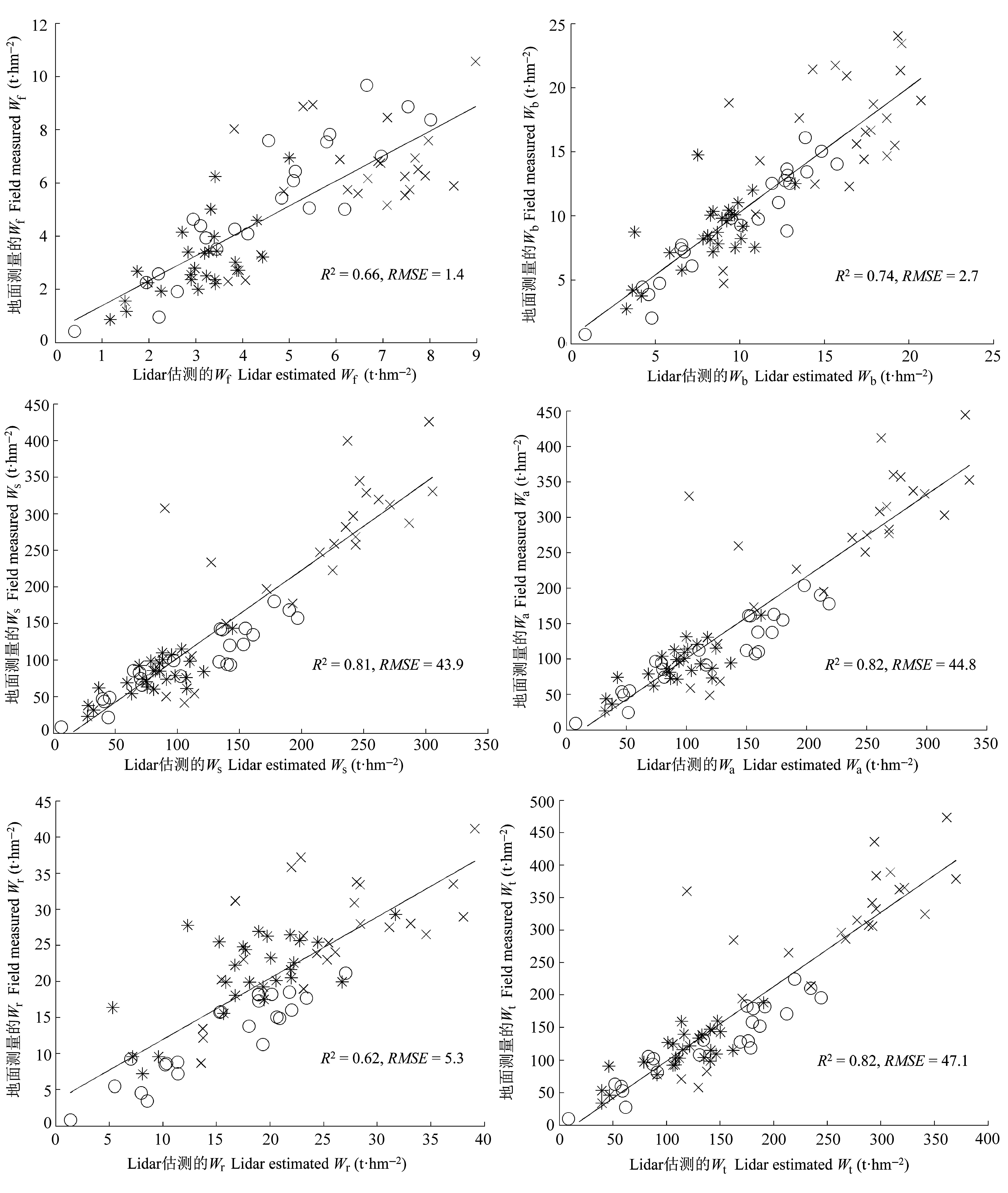
Fig. 1 Comparison of estimated biomass components from field measurements and airborne Lidar (unit: t·hm-2). *, broad-leaved forest; ○, needle-leaved forest; × , needle-broad-leaved mixed forest; R2, coefficient of determination; RMSE, root mean square error; Wa, aboveground biomass; Wb, live branch biomass; Wf, leaf biomass; Wr, root biomass; Ws, trunk biomass; Wt, total biomass.
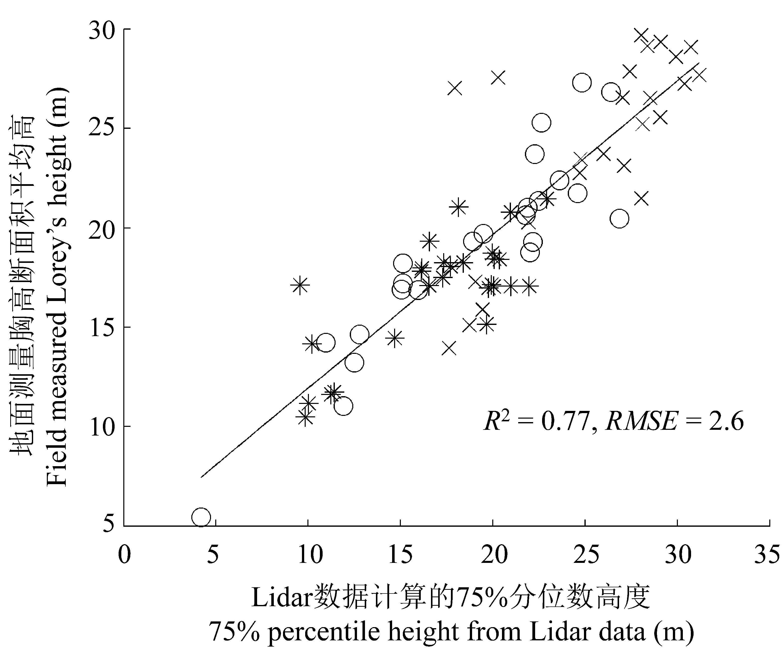
Fig. 2 Comparison of Lorey’s height (basal area weighted mean height) from field measurements and 75% percentile height from airborne Lidar data. *, broad-leaved forest; ○, needle-leaved forest; × , needle-broad-leaved mixed forest; R2, coefficient of determination; RMSE, root mean square error.
| 评价指标 Evaluation index | 森林类型 Forest type | 组分生物量 Biomass component | ||||||
|---|---|---|---|---|---|---|---|---|
| Wf | Wb | Ws | Wa | Wr | Wt | |||
| 决定系数 Coefficient of determination R2 | 阔叶林 Broad-leaved forest | 0.96 | 0.92 | 0.89 | 0.88 | 0.82 | 0.95 | |
| 针叶林 Needle-leaved forest | 0.97 | 0.91 | 0.97 | 0.95 | 0.85 | 0.95 | ||
| 针阔叶混交林 Needle-broad-leaved mixed forest | 0.82 | 0.61 | 0.79 | 0.80 | 0.79 | 0.82 | ||
| 均方根误差 Root mean square error RMSE | 阔叶林 Broad-leaved forest | 0.30 | 0.80 | 8.90 | 10.30 | 2.50 | 8.10 | |
| 针叶林 Needle-leaved forest | 0.50 | 1.30 | 8.30 | 12.20 | 2.20 | 13.30 | ||
| 针阔叶混交林 Needle-broad-leaved mixed forest | 0.90 | 3.30 | 49.5 | 48.90 | 3.70 | 48.90 | ||
| 相对均方根误差 Relative root mean square error rRMSE | 阔叶林 Broad-leaved forest | 0.10 | 0.09 | 0.11 | 0.11 | 0.12 | 0.07 | |
| 针叶林 Needle-leaved forest | 0.10 | 0.14 | 0.08 | 0.11 | 0.18 | 0.11 | ||
| 针阔叶混交林 Needle-broad-leaved mixed forest | 0.14 | 0.20 | 0.20 | 0.18 | 0.14 | 0.17 | ||
Table 2 Results of biomass component regression models from variable selection and model establishment categoried by forest types
| 评价指标 Evaluation index | 森林类型 Forest type | 组分生物量 Biomass component | ||||||
|---|---|---|---|---|---|---|---|---|
| Wf | Wb | Ws | Wa | Wr | Wt | |||
| 决定系数 Coefficient of determination R2 | 阔叶林 Broad-leaved forest | 0.96 | 0.92 | 0.89 | 0.88 | 0.82 | 0.95 | |
| 针叶林 Needle-leaved forest | 0.97 | 0.91 | 0.97 | 0.95 | 0.85 | 0.95 | ||
| 针阔叶混交林 Needle-broad-leaved mixed forest | 0.82 | 0.61 | 0.79 | 0.80 | 0.79 | 0.82 | ||
| 均方根误差 Root mean square error RMSE | 阔叶林 Broad-leaved forest | 0.30 | 0.80 | 8.90 | 10.30 | 2.50 | 8.10 | |
| 针叶林 Needle-leaved forest | 0.50 | 1.30 | 8.30 | 12.20 | 2.20 | 13.30 | ||
| 针阔叶混交林 Needle-broad-leaved mixed forest | 0.90 | 3.30 | 49.5 | 48.90 | 3.70 | 48.90 | ||
| 相对均方根误差 Relative root mean square error rRMSE | 阔叶林 Broad-leaved forest | 0.10 | 0.09 | 0.11 | 0.11 | 0.12 | 0.07 | |
| 针叶林 Needle-leaved forest | 0.10 | 0.14 | 0.08 | 0.11 | 0.18 | 0.11 | ||
| 针阔叶混交林 Needle-broad-leaved mixed forest | 0.14 | 0.20 | 0.20 | 0.18 | 0.14 | 0.17 | ||
| 1 | Axelsson P (2001). Ground estimation of laser data using adaptive TIN-models. In: Torlegård K, Nelson J eds. Proceedings of OEEPE Workshop on Airborne Laserscanning and Interferometric SAR for Detailed Digital Elevation Models. Royal Institute of Technology, Stockholm,Sweden. 185-208. |
| 3 | Chen CG ( 陈传国), Zhu JF ( 朱俊凤 ) (1989). Woody Biomass Manual of Typical Species in the Northeast of China (东北主要林木生物量手册). China Forestry Publishing House, Beijing. (in Chinese) |
| 4 | Feng ZW ( 冯宗炜), Wang XK ( 王效科), Wu G ( 吴刚 ) (1999). Biomass and Productivity of Chinese Forest Ecosystem (中国森林生态系统的生物量和生产力). Science Press, Beijing. (in Chinese) |
| 5 | Fu T ( 付甜), Pang Y ( 庞勇), Huang QF ( 黄庆丰), Liu QW ( 刘清旺), Xu GC ( 徐光彩 ) ( 2011). Subtropical forest parameters estimation using airborne Lidar data. Journal of Remote Sensing (遥感学报), 15, 1092-1098. (in Chinese with English abstract) |
| 6 | Hall SA, Burke IC, Box DO, Kaufmann MR, Stoker JM ( 2005). Estimating stand structure using discrete-return lidar: an example from low density, fire prone ponderosa pine forests. Forest Ecology and Management, 208, 189-209. |
| 7 | Holmgren J ( 2004). Prediction of tree height, basal area and stem volume in forest stands using airborne laser scanning. Scandinavian Journal of Forest Research, 19, 543-553. |
| 8 | Latifi H, Nothdurft A, Koch B ( 2010). Non-parametric prediction and mapping of standing timber volume and biomass in a temperate forest: application of multiple optical/ LiDAR-derived predictors. Forestry, 83, 395-407. |
| 9 | Lim KS, Treitz PM ( 2004). Estimation of aboveground forest biomass from airborne discrete return laser scanner data using canopy-based quantile estimators. Scandinavian Journal of Forest Research, 19, 558-570. |
| 10 | Liu QW ( 刘清旺), Li ZY ( 李增元), Chen EX ( 陈尔学), Pang Y ( 庞勇), Tian X ( 田欣), Cao CX ( 曹春香 ) ( 2010). Estimating biomass of individual trees using point cloud data of airborne Lidar. Chinese High Technology Letters (高技术通讯), 20, 765-770. (in Chinese with English abstract) |
| 11 | MacLean GA, Krabill WB ( 1986). Gross merchantable timber volume estimation using an airborne LiDAR system. Canadian Journal of Remote Sensing, 12, 7-l8. |
| 12 | Maltamo M, Eerikäinen K, Pitkänen J, Hyyppä J, Vehmas M ( 2004). Estimation of timber volume and stem density based on scanning laser altimetry and expected tree size distribution functions. Remote Sensing of Environment, 90, 319-330. |
| 13 | Næsset E ( 1997). Determination of mean tree height of forest stands using airborne laser scanner data. ISPRS Journal of Photogrammetry and Remote Sensing, 52, 49-56. |
| 14 | Næsset E, Gobakken T ( 2008). Estimation of above- and below-ground biomass across regions of the boreal forest zone using airborne laser. Remote Sensing of Environment, 112, 3079-3090. |
| 15 | Nelson R, Krabill W, MacLean G ( 1984). Determining forest canopy characteristics using airborne laser data. Remote Sensing of Environment, 15, 201-212. |
| 16 | Nelson R, Krabill W, Tonelli J ( 1988). Estimating forest biomass and volume using airborne laser data. Remote Sensing of Environment, 24, 247-267. |
| 17 | Nelson R, Oderwald R, Gregoire TG ( 1997). Separating the ground and airborne laser sampling phases to estimate tropical forest basal area, volume, and biomass. Remote Sensing of Environment, 60, 311-326. |
| 18 | Nilsson M ( 1996). Estimation of tree heights and stand volume using an airborne Lidar system. Remote Sensing of Environment, 56, 1-7. |
| 19 |
Pang Y ( 庞勇), Li ZY ( 李增元), Chen EX ( 陈尔学), Sun GQ ( 孙国清 ) ( 2005). Lidar remote sensing technology and its application in forestry. Scientia Silvae Sinicae (林业科学), 41(3), 129-136. (in Chinese with English abstract)
DOI URL |
| 20 | Pang Y ( 庞勇), Zhao F ( 赵峰), Li ZY ( 李增元), Zhou SF ( 周淑芳), Deng G ( 邓广), Liu Q ( 刘清旺), Chen E ( 陈尔学 ) ( 2008). Forest height inversion using airborne Lidar technology. Journal of Remote Sensing (遥感学报), 12, 152-158. (in Chinese with English abstract) |
| 21 | Popescu SC ( 2007). Estimating biomass of individual pine trees using airborne Lidar. Biomass and Bioenergy, 31, 646-655. |
| 22 | Wang C ( 2006). Biomass allometric equations for 10 co- occurring tree species in Chinese temperate forests. Forest Ecology and Management, 222, 9-16. |
| 23 | Zhao K, Popescu S, Nelson R ( 2009). Lidar remote sensing of forest biomass: a scale-invariant estimation approach using airborne lasers. Remote Sensing of Environment, 113, 182-196. |
| [1] | HUANG Ling, WANG Zhen, MA Ze, YANG Fa-Lin, LI Lan, SEREKPAYEV Nurlan, NOGAYEV Adilbek, HOU Fu-Jiang. Effects of long-term grazing and nitrogen addition on the growth of Stipa bungeana population in typical steppe of Loess Plateau [J]. Chin J Plant Ecol, 2024, 48(3): 317-330. |
| [2] | ZHAO Yan-Chao, CHEN Li-Tong. Soil nutrients modulate response of aboveground biomass to warming in alpine grassland on the Qingzang Plateau [J]. Chin J Plant Ecol, 2023, 47(8): 1071-1081. |
| [3] | HAO Qing, HUANG Chang. A review of forest aboveground biomass estimation based on remote sensing data [J]. Chin J Plant Ecol, 2023, 47(10): 1356-1374. |
| [4] | DONG Liu-Wen, REN Zheng-Wei, ZHANG Rui, XIE Chen-Di, ZHOU Xiao-Long. Functional diversity rather than species diversity can explain community biomass variation following short-term nitrogen addition in an alpine grassland [J]. Chin J Plant Ecol, 2022, 46(8): 871-881. |
| [5] | DONG Han-Jun, WANG Xing-Chang, YUAN Dan-Yang, LIU Di, LIU Yu-Long, SANG Ying, WANG Xiao-Chun. Radial distribution differences of non-structural carbohydrates in stems of tree species of different wood in a temperate forest [J]. Chin J Plant Ecol, 2022, 46(6): 722-734. |
| [6] | YU Hai-Ying, YANG Li-Lin, FU Su-Jing, ZHANG Zhi-Min, YAO Qi-Fu. Response of leaf-unfolding dates of woody species to variation of chilling and heat accumulation in warm temperate forests [J]. Chin J Plant Ecol, 2022, 46(12): 1573-1584. |
| [7] | HUANG Kuai-Kuai, HU Gang, PANG Qing-Ling, ZHANG Bei, HE Ye-Yong, HU Cong, XU Chao-Hao, ZHANG Zhong-Hua. Effects of grazing on species composition and community structure of shrub tussock in subtropical karst mountains, southwest China [J]. Chin J Plant Ecol, 2022, 46(11): 1350-1363. |
| [8] | CHEN Zhe, WANG Hao, WANG Jin-Zhou, SHI Hui-Jin, LIU Hui-Ying, HE Jin-Sheng. Estimation on seasonal dynamics of alpine grassland aboveground biomass using phenology camera-derived NDVI [J]. Chin J Plant Ecol, 2021, 45(5): 487-495. |
| [9] | WEI Chun-Xue, YANG Lu, WANG Jin-Song, YANG Jia-Ming, SHI Jia-Wei, TIAN Da-Shuan, ZHOU Qing-Ping, NIU Shu-Li. Effects of experimental warming on root biomass in terrestrial ecosystems [J]. Chin J Plant Ecol, 2021, 45(11): 1203-1212. |
| [10] | ZOU An-Long,LI Xiu-Ping,NI Xiao-Feng,JI Cheng-Jun. Responses of tree growth to nitrogen addition in Quercus wutaishanica forests in Mount Dongling, Beijing, China [J]. Chin J Plant Ecol, 2019, 43(9): 783-792. |
| [11] | MIAO Bai-Ling, LIANG Cun-Zhu, SHI Ya-Bo, LIANG Mao-Wei, LIU Zhong-Ling. Temporal changes in precipitation altered aboveground biomass in a typical steppe in Nei Mongol, China [J]. Chin J Plant Ecol, 2019, 43(7): 557-565. |
| [12] | ZHAO Dan-Dan, MA Hong-Yuan, LI Yang, WEI Ji-Ping, WANG Zhi-Chun. Effects of water and nutrient additions on functional traits and aboveground biomass of Leymus chinensis [J]. Chin J Plant Ecol, 2019, 43(6): 501-511. |
| [13] | Qian YANG, Wei WANG, Hui ZENG. Effects of nitrogen addition on the plant diversity and biomass of degraded grasslands of Nei Mongol, China [J]. Chin J Plant Ecol, 2018, 42(4): 430-441. |
| [14] | ZHANG Lu, HAO Bi-Tai, QI Li-Xue, LI Yan-Long, XU Hui-Min, YANG Li-Na, BAOYIN Taogetao. Dynamic responses of aboveground biomass and soil organic matter content to grassland restoration [J]. Chin J Plant Ecol, 2018, 42(3): 317-326. |
| [15] | CEN Yu, WANG Cheng-Dong, ZHANG Zhen, REN Xia, LIU Mei-Zhen, YANG Fan. Spatial distributions of biomass and carbon density in natural grasslands of Hebei, China [J]. Chin J Plant Ecol, 2018, 42(3): 265-276. |
| Viewed | ||||||
|
Full text |
|
|||||
|
Abstract |
|
|||||
Copyright © 2022 Chinese Journal of Plant Ecology
Tel: 010-62836134, 62836138, E-mail: apes@ibcas.ac.cn, cjpe@ibcas.ac.cn