
Chin J Plant Ecol ›› 2021, Vol. 45 ›› Issue (4): 355-369.DOI: 10.17521/cjpe.2020.0226
• Research Articles • Previous Articles Next Articles
ZHOU Ming-Xing1, LI Deng-Qiu2,*( ), ZOU Jian-Jun1
Received:2020-07-08
Accepted:2021-02-04
Online:2021-04-20
Published:2021-03-27
Contact:
LI Deng-Qiu
Supported by:ZHOU Ming-Xing, LI Deng-Qiu, ZOU Jian-Jun. Vegetation change of giant panda habitats in Qionglai Mountains through dense Landsat Data[J]. Chin J Plant Ecol, 2021, 45(4): 355-369.
Add to citation manager EndNote|Ris|BibTeX
URL: https://www.plant-ecology.com/EN/10.17521/cjpe.2020.0226
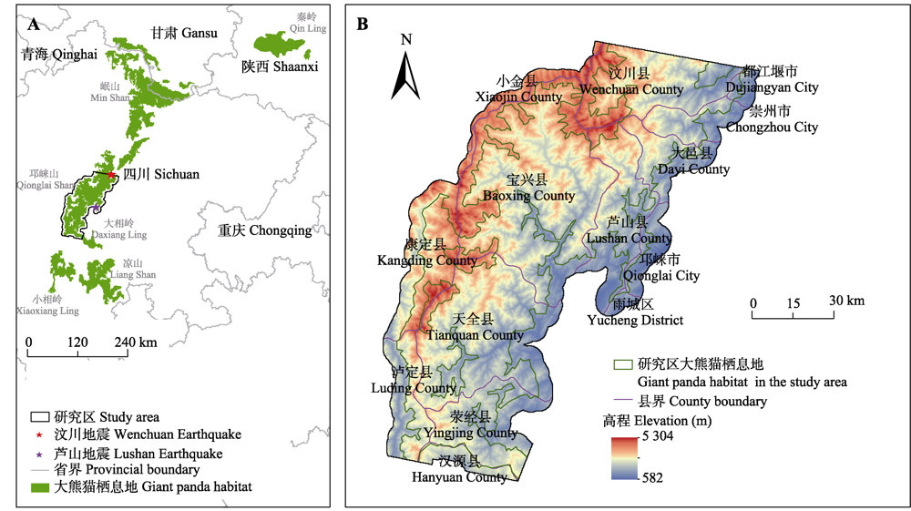
Fig. 1 Location of the study area of giant panda habitats in Qionglai Mountains. The boundary of giant panda habitats (including potential habitats) is from the Fourth National Giant Panda Survey.
| 因子类型 Factor type | 因子 Factor | 空间分辨率 Spatial resolution (m) | 预处理(重采样) Preprocessing (resampling) |
|---|---|---|---|
| 气候 Climate | 年降水量 Mean annual precipitation (X1) | 1 000 | 双线性内插法 Bilinear interpolation |
| 年平均气温 Mean annual air temperature (X2) | 1 000 | 双线性内插法 Bilinear interpolation | |
| 地形 Topography | 高程 Elevation (X3) | 30 | - |
| 坡度 Slope (X4) | 30 | - | |
| 坡向 Aspect (X5) | 30 | - | |
| 河流 River | 与河流距离 Distance to rivers (X6) | 30 | - |
| 土壤类型 Soil type | 土壤类型 Soil type (X7) | 1 000 | 最邻近内插法 Nearest interpolation |
| 人类活动 Human activity | 土地覆盖类型 Land cover type (X8) | 30 | - |
| 与道路距离 Distance to roads (X9) | 30 | - | |
| 与工程扰动区距离 Distance to engineering disturbance area (X10) | 30 | - |
Table 1 Drivers of vegetation change of giant panda habitats in Qionglai Mountains
| 因子类型 Factor type | 因子 Factor | 空间分辨率 Spatial resolution (m) | 预处理(重采样) Preprocessing (resampling) |
|---|---|---|---|
| 气候 Climate | 年降水量 Mean annual precipitation (X1) | 1 000 | 双线性内插法 Bilinear interpolation |
| 年平均气温 Mean annual air temperature (X2) | 1 000 | 双线性内插法 Bilinear interpolation | |
| 地形 Topography | 高程 Elevation (X3) | 30 | - |
| 坡度 Slope (X4) | 30 | - | |
| 坡向 Aspect (X5) | 30 | - | |
| 河流 River | 与河流距离 Distance to rivers (X6) | 30 | - |
| 土壤类型 Soil type | 土壤类型 Soil type (X7) | 1 000 | 最邻近内插法 Nearest interpolation |
| 人类活动 Human activity | 土地覆盖类型 Land cover type (X8) | 30 | - |
| 与道路距离 Distance to roads (X9) | 30 | - | |
| 与工程扰动区距离 Distance to engineering disturbance area (X10) | 30 | - |
| 突变次数 Number of abrupt change | 占研究区比例 Proportion of study area (%) | 占突变区域比例 Proportion of abrupt change area (%) | ||
|---|---|---|---|---|
| 栖息地 Habitat | 外围区域 Peripheral area | 栖息地 Habitat | 外围区域 Peripheral area | |
| 0 | 58.09 | 32.78 | - | - |
| 1 | 5.74 | 2.92 | 62.87 | 31.98 |
| 2 | 0.24 | 0.21 | 2.63 | 2.30 |
| 3 | 0.01 | 0.01 | 0.11 | 0.11 |
| 4 | 0.00 | 0.00 | 0.00 | 0.00 |
| ≥1 | 5.99 | 3.14 | 65.61 | 34.39 |
Table 2 Area proportion for various number of vegetation abrupt change of giant panda habitats in Qionglai Mountains during 1986-2018
| 突变次数 Number of abrupt change | 占研究区比例 Proportion of study area (%) | 占突变区域比例 Proportion of abrupt change area (%) | ||
|---|---|---|---|---|
| 栖息地 Habitat | 外围区域 Peripheral area | 栖息地 Habitat | 外围区域 Peripheral area | |
| 0 | 58.09 | 32.78 | - | - |
| 1 | 5.74 | 2.92 | 62.87 | 31.98 |
| 2 | 0.24 | 0.21 | 2.63 | 2.30 |
| 3 | 0.01 | 0.01 | 0.11 | 0.11 |
| 4 | 0.00 | 0.00 | 0.00 | 0.00 |
| ≥1 | 5.99 | 3.14 | 65.61 | 34.39 |
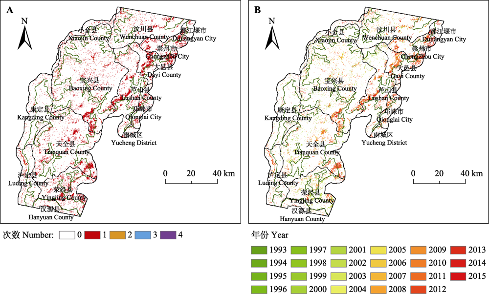
Fig. 2 Spatial distribution of vegetation abrupt change of giant panda habitats in Qionglai Mountains during 1986-2018. A, Number of abrupt change. B, Year of the latest abrupt change.
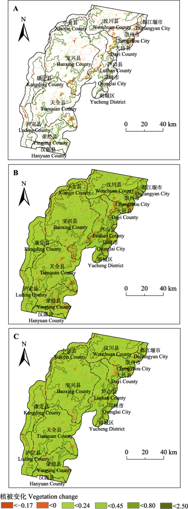
Fig. 3 Vegetation change of giant panda habitats in Qionglai Mountains during 1986-2018. A, Vegetation accumulated abrupt change. B, Vegetation accumulated gradual change. C, Vegetation total change.
| 因子 Factor | 植被累积突变 Vegetation accumulated abrupt change | 植被累积渐变 Vegetation accumulated gradual change | 植被总变化 Vegetation total change | ||||||
|---|---|---|---|---|---|---|---|---|---|
| q | p(sig) | q排序 Sequence of q | q | p(sig) | q排序 Sequence of q | q | p(sig) | q排序 Sequence of q | |
| X1 | 0.048 1 | 2.78E-10 | 1 | 0.031 5 | 6.49E-11 | 4 | 0.068 1 | 6.44E-10 | 5 |
| X2 | 0.021 3 | 2.89E-10 | 2 | 0.037 6 | 6.14E-12 | 2 | 0.089 1 | 2.69E-11 | 3 |
| X3 | 0.018 9 | 1.56E-10 | 3 | 0.037 7 | 5.38E-10 | 1 | 0.089 6 | 8.18E-10 | 2 |
| X4 | 0.001 1 | 5.61E-11 | 10 | 0.000 3 | 2.78E-10 | 10 | 0.001 5 | 5.49E-10 | 10 |
| X5 | 0.001 4 | 5.03E-10 | 9 | 0.001 6 | 2.10E-10 | 9 | 0.005 8 | 1.87E-10 | 9 |
| X6 | 0.011 7 | 4.07E-11 | 5 | 0.012 3 | 6.59E-10 | 6 | 0.028 2 | 3.72E-10 | 6 |
| X7 | 0.013 6 | 3.11E-11 | 4 | 0.037 5 | 1.95E-10 | 3 | 0.097 4 | 6.81E-10 | 1 |
| X8 | 0.005 9 | 5.49E-10 | 7 | 0.023 8 | 4.22E-10 | 5 | 0.079 7 | 3.07E-10 | 4 |
| X9 | 0.010 6 | 2.98E-10 | 6 | 0.008 0 | 6.97E-11 | 7 | 0.018 3 | 9.47E-10 | 7 |
| X10 | 0.002 5 | 2.20E-11 | 8 | 0.003 1 | 6.36E-10 | 8 | 0.010 3 | 2.07E-10 | 8 |
Table 3 Results of factor detector of giant panda habitats in Qionglai Mountains (q)
| 因子 Factor | 植被累积突变 Vegetation accumulated abrupt change | 植被累积渐变 Vegetation accumulated gradual change | 植被总变化 Vegetation total change | ||||||
|---|---|---|---|---|---|---|---|---|---|
| q | p(sig) | q排序 Sequence of q | q | p(sig) | q排序 Sequence of q | q | p(sig) | q排序 Sequence of q | |
| X1 | 0.048 1 | 2.78E-10 | 1 | 0.031 5 | 6.49E-11 | 4 | 0.068 1 | 6.44E-10 | 5 |
| X2 | 0.021 3 | 2.89E-10 | 2 | 0.037 6 | 6.14E-12 | 2 | 0.089 1 | 2.69E-11 | 3 |
| X3 | 0.018 9 | 1.56E-10 | 3 | 0.037 7 | 5.38E-10 | 1 | 0.089 6 | 8.18E-10 | 2 |
| X4 | 0.001 1 | 5.61E-11 | 10 | 0.000 3 | 2.78E-10 | 10 | 0.001 5 | 5.49E-10 | 10 |
| X5 | 0.001 4 | 5.03E-10 | 9 | 0.001 6 | 2.10E-10 | 9 | 0.005 8 | 1.87E-10 | 9 |
| X6 | 0.011 7 | 4.07E-11 | 5 | 0.012 3 | 6.59E-10 | 6 | 0.028 2 | 3.72E-10 | 6 |
| X7 | 0.013 6 | 3.11E-11 | 4 | 0.037 5 | 1.95E-10 | 3 | 0.097 4 | 6.81E-10 | 1 |
| X8 | 0.005 9 | 5.49E-10 | 7 | 0.023 8 | 4.22E-10 | 5 | 0.079 7 | 3.07E-10 | 4 |
| X9 | 0.010 6 | 2.98E-10 | 6 | 0.008 0 | 6.97E-11 | 7 | 0.018 3 | 9.47E-10 | 7 |
| X10 | 0.002 5 | 2.20E-11 | 8 | 0.003 1 | 6.36E-10 | 8 | 0.010 3 | 2.07E-10 | 8 |
| 植被累积突变 Vegetation accumulated abrupt change | 植被累积渐变 Vegetation accumulated gradual change | 植被总变化 Vegetation total change | |||
|---|---|---|---|---|---|
| 因子 Factor | q | 因子 Factor | q | 因子 Factor | q |
| X1∩X6 | 0.071 4* | X7∩X1 | 0.052 5 | X7∩X3 | 0.134 8 |
| X1∩X7 | 0.068 9* | X7∩X3 | 0.050 2 | X7∩X8 | 0.133 4 |
| X1∩X2 | 0.065 3 | X7∩X2 | 0.049 7 | X7∩X2 | 0.131 9 |
| X1∩X3 | 0.064 0 | X7∩X8 | 0.047 5 | X7∩X1 | 0.130 2 |
| X1∩X9 | 0.061 9* | X3∩X1 | 0.045 7 | X8∩X3 | 0.122 6 |
| X1∩X10 | 0.061 5* | X8∩X3 | 0.045 0 | X8∩X2 | 0.121 5 |
| X1∩X8 | 0.057 0* | X8∩X2 | 0.045 0 | X7∩X6 | 0.117 8 |
| X1∩X5 | 0.051 9* | X8∩X1 | 0.044 9 | X7∩X9 | 0.114 5 |
| X1∩X4 | 0.051 0* | X7∩X6 | 0.044 4 | X8∩X1 | 0.113 8 |
Table 4 Results of interaction detector (the first nine larger q were selected and ranked for each vegetation change) of giant panda habitats in Qionglai Mountains
| 植被累积突变 Vegetation accumulated abrupt change | 植被累积渐变 Vegetation accumulated gradual change | 植被总变化 Vegetation total change | |||
|---|---|---|---|---|---|
| 因子 Factor | q | 因子 Factor | q | 因子 Factor | q |
| X1∩X6 | 0.071 4* | X7∩X1 | 0.052 5 | X7∩X3 | 0.134 8 |
| X1∩X7 | 0.068 9* | X7∩X3 | 0.050 2 | X7∩X8 | 0.133 4 |
| X1∩X2 | 0.065 3 | X7∩X2 | 0.049 7 | X7∩X2 | 0.131 9 |
| X1∩X3 | 0.064 0 | X7∩X8 | 0.047 5 | X7∩X1 | 0.130 2 |
| X1∩X9 | 0.061 9* | X3∩X1 | 0.045 7 | X8∩X3 | 0.122 6 |
| X1∩X10 | 0.061 5* | X8∩X3 | 0.045 0 | X8∩X2 | 0.121 5 |
| X1∩X8 | 0.057 0* | X8∩X2 | 0.045 0 | X7∩X6 | 0.117 8 |
| X1∩X5 | 0.051 9* | X8∩X1 | 0.044 9 | X7∩X9 | 0.114 5 |
| X1∩X4 | 0.051 0* | X7∩X6 | 0.044 4 | X8∩X1 | 0.113 8 |
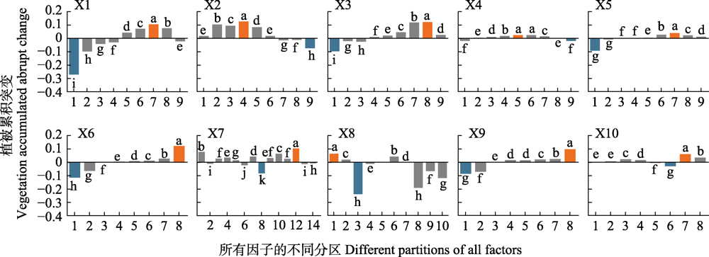
Fig. 4 Risk detection result of vegetation accumulated abrupt change of giant panda habitats in Qionglai Mountains. Different lowercase letters indicate significant differences between the different partitions (p < 0.05). The factors (X1-X10) are the same as Table 1.
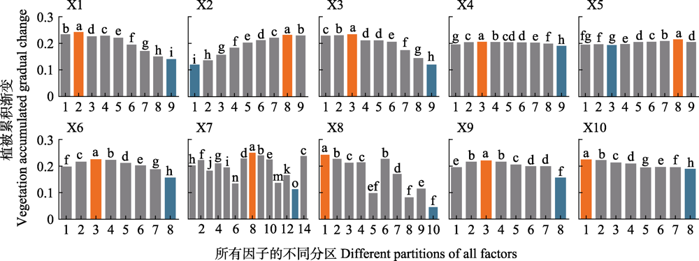
Fig. 5 Risk detection result of vegetation accumulated gradual change of giant panda habitats in Qionglai Mountains. Different lowercase letters indicate significant differences between the different partitions (p < 0.05). The factors (X1-X10) are the same as Table 1.
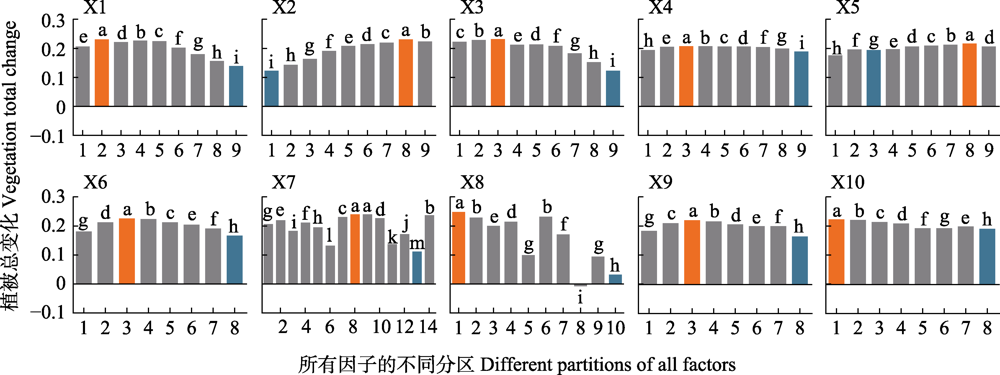
Fig. 6 Risk detection result of vegetation total change of giant panda habitats in Qionglai Mountains. Different lowercase letters indicate significant differences between the different partitions (p < 0.05). The factors (X1-X10) are the same as Table 1.
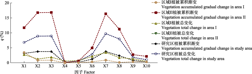
Fig. 7 Impacts of vegetation abrupt change of giant panda habitats in Qionglai Mountains on the results of factor detector (q). Area I represents the area where vegetation abrupt change is detected, and area II represents the area where vegetation abrupt change is not detected. The factors (X1-X10) are the same asTable 1.
| [1] |
Ameca EI, Dai Q, Nie YG, Gu XD, Wei FW (2019). Implications of flood disturbance for conservation and management of giant panda habitat in human-modified landscapes. Biological Conservation, 232, 35-42.
DOI |
| [2] | Bai WK ( 2017). The Dynamics of Space Utilization and Habitat Selection of Giant Pandas (Ailuropoda melanoleuca) in Wolong Nature Reserve . PhD dissertation, Inner Mongolia Agricultural University,Hohhot. |
| [ 白文科 ( 2017). 卧龙自然保护区大熊猫空间利用与生境选择动态变化研究. 博士学位论文, 内蒙古农业大学, 呼和浩特.] | |
| [3] | Cao F, Ge Y, Wang JF (2013). Optimal discretization for geographical detectors-based risk assessment. GIScience & Remote Sensing, 50, 78-92. |
| [4] | Chen B, Li HD, Cao XZ ( 2014). Advances in studies on degradation and re-vegetation of typical ecosystems on Tibetan Plateau, China. World Forestry Research, 27(5), 18-23. |
| [ 陈斌, 李海东, 曹学章 ( 2014). 西藏高原典型生态系统退化及植被恢复技术综述. 世界林业研究, 27(5), 18-23.] | |
| [5] | Chen JL, Xia JG, Yu YH ( 2020). Correlation analysis of vegetation coverage and topographic factors in Yaʼan City based on RS and GIS. Journal of Anhui Agricultural Sciences, 48(5), 88-92. |
| [ 陈家良, 夏建国, 余雨红 ( 2020). 基于RS和GIS的雅安市植被覆盖度与地形因子相关分析. 安徽农业科学, 48(5), 88-92.] | |
| [6] |
Chen LF, Michishita R, Xu B (2014). Abrupt spatiotemporal land and water changes and their potential drivers in Poyang Lake, 2000-2012. ISPRS Journal of Photogrammetry and Remote Sensing, 98, 85-93.
DOI URL |
| [7] |
Deng XZ, Jiang QO, Ge QS, Yang LS (2010). Impacts of the Wenchuan Earthquake on the giant panda nature reserves in China. Journal of Mountain Science, 7, 197-206.
DOI URL |
| [8] |
DeVries B, Verbesselt J, Kooistra L, Herold M (2015). Robust monitoring of small-scale forest disturbances in a tropical montane forest using Landsat time series. Remote Sensing of Environment, 161, 107-121.
DOI URL |
| [9] | Dong BN ( 2017). Spatio-temporal Variations of Habitat Selection by Giant Pandas and its Habitat Disturbance in Qionglai Mountains, China . Master degree dissertation, China West Normal University, Nanchong,Sichuan. |
| [ 董冰楠 ( 2017). 邛崃山系大熊猫生境选择及栖息地干扰时空变化研究. 硕士学位论文, 西华师范大学, 四川南充.] | |
| [10] | Dutrieux LP, DeVries B, Verbesselt J (2016a). bfastSpatial: Utilities to monitor for change on satellite image time-series. R package version 0.6.3. [2016-10-22]. https://github.com/loicdtx/ bfast Spatial. |
| [11] |
Dutrieux LP, Jakovac CC, Latifah SH, Kooistra L (2016b). Reconstructing land use history from Landsat time-series: case study of a swidden agriculture system in Brazil. International Journal of Applied Earth Observation and Geoinformation, 47, 112-124.
DOI URL |
| [12] |
Fang XQ, Zhu QA, Ren LL, Chen H, Wang K, Peng CH (2018). Large-scale detection of vegetation dynamics and their potential drivers using MODIS images and BFAST: a case study in Quebec, Canada. Remote Sensing of Environment, 206, 391-402.
DOI URL |
| [13] | Forestry Department of Sichuan Province ( 2015). The Panda of Sichuan: the 4th Survey Report on Giant Panda in Sichuan Province. Sichuan Science and Technology Press, Chengdu. |
| [四川省林业厅 ( 2015). 四川的大熊猫: 四川省第四次大熊猫调查报告. 四川科学技术出版社, 成都.] | |
| [14] |
Fu G, Sun W, Li SW, Zhang J, Yu CQ, Shen ZX (2017). Modeling aboveground biomass using MODIS images and climatic data in grasslands on the Tibetan Plateau. Journal of Resources and Ecology, 8, 42-49.
DOI URL |
| [15] |
Geng LY, Che T, Wang XF, Wang HB (2019). Detecting spatiotemporal changes in vegetation with the BFAST model in the Qilian Mountain Region during 2000-2017. Remote Sensing, 11, 103. DOI: 10.3390/rs11020103.
DOI URL |
| [16] | He Q, Yang XQ, Dai XA ( 2020). Variation characteristics and influence factors of net primary productivity of vegetation in the Three-River Headwaters Region from 2010 to 2015. Journal of Yangtze River Scientific Research Institute, 37(5), 59-66. |
| [ 贺倩, 杨雪琴, 戴晓爱 ( 2020). 2010-2015年三江源地区植被净初级生产力变化特征及影响因素分析. 长江科学院院报, 37(5), 59-66.] | |
| [17] | Hijmans RJ (2020). Raster: geographic data analysis and modeling. R package version 3.3-13. [2020-07-16]. https:// CRAN.R-project.org/package=raster. |
| [18] | Huang YL, Liang CT, Wu J, Wang CL, Liu ZQ, Jiang NB ( 2020). The seismicity in the southern Longmenshan fault zone based on a dense seismic array. Chinese Journal of Geophysics, 63, 1183-1196. |
| [ 黄焱羚, 梁春涛, 吴晶, 王朝亮, 刘志强, 江宁波 ( 2020). 基于密集台阵研究龙门山断裂带南段地震空段的地震活动性. 地球物理学报, 63, 1183-1196.] | |
| [19] | Jenks GF (1967). The data model concept in statistical mapping. International Yearbook of Cartography, 7, 186-190. |
| [20] |
Jian J, Jiang H, Zhou GM, Jiang ZS, Yu SQ, Peng SL, Liu SY, Wang JX (2011). Mapping the vegetation changes in giant panda habitat using Landsat remotely sensed data. International Journal of Remote Sensing, 32, 1339-1356.
DOI URL |
| [21] |
Jiao QJ, Zhang B, Liu LY, Li ZW, Yue YM, Hu Y (2014). Assessment of spatio-temporal variations in vegetation recovery after the Wenchuan earthquake using Landsat data. Natural Hazards, 70, 1309-1326.
DOI URL |
| [22] | Kang D, Zou SZ ( 2019). Advances in regeneration of plants after earthquake in giant pandas’ habitat. Ecological Science, 38(6), 178-183. |
| [ 康迪, 邹书珍 ( 2019). 大熊猫栖息地地震受损植被恢复研究进展. 生态科学, 38(6), 178-183.] | |
| [23] |
Kang DW, Zhao ZJ, Chen XY, Lin YC, Wang XR, Li JQ (2020). Evaluating the effects of roads on giant panda habitat at two scales in a typical nature reserve. Science of the Total Environment, 710, 136351. DOI: 10.1016/j.scitotenv.2019. 136351.
DOI URL |
| [24] |
Kong W, Sun OJ, Chen Y, Yu Y, Tian Z (2010). Patch-level based vegetation change and environmental drivers in Tarim River drainage area of West China. Landscape Ecology, 25, 1447-1455.
DOI URL |
| [25] |
Li DQ, Lu DS, Wu M, Shao XX, Wei JH (2017). Examining land cover and greenness dynamics in Hangzhou Bay in 1985-2016 using Landsat time-series data. Remote Sensing, 10, 32. DOI: 10.3390/rs10010032.
DOI URL |
| [26] | Li JZ, Cao MM, Qiu HJ, Xue B, Hu S, Cui P ( 2016). Spatial- temporal process and characteristics of vegetation recovery after Wenchuan earthquake: a case study in Longxi River basin of Dujiangyan, China. Chinese Journal of Applied Ecology, 27, 3479-3486. |
| [ 李京忠, 曹明明, 邱海军, 薛冰, 胡胜, 崔鹏 ( 2016). 汶川地震区灾后植被恢复时空过程及特征——以都江堰龙溪河流域为例. 应用生态学报, 27, 3479-3486.] | |
| [27] |
Li Y, Viña A, Yang W, Chen XD, Zhang JD, Ouyang ZY, Liang Z, Liu JG (2013). Effects of conservation policies on forest cover change in giant panda habitat regions, China. Land Use Policy, 33, 42-53.
DOI URL |
| [28] | Li YY, You LL, Chen YS, Huang JX ( 2018). Spatial-temporal characteristics of multi-pond landscape change and their driving factors in the Chaohu Basin, China. Acta Ecologica Sinica, 38, 6280-6291. |
| [ 李莹莹, 尤罗利, 陈永生, 黄季夏 ( 2018). 环巢湖地区多水塘景观时空格局演变特征及其驱动因素. 生态学报, 38, 6280-6291.] | |
| [29] | Liang YX, Wang G, Wang HR ( 2018). GIS-based analysis on giant panda habitat characteristics in National Giant Panda Park of Sichuan Province. Journal of Sichuan Forestry Science and Technology, 39(4), 98-101. |
| [ 梁玉喜, 王戈, 王洪荣 ( 2018). 基于GIS大熊猫活动区域环境特征分析——以大熊猫国家公园(四川)为例. 四川林业科技, 39(4), 98-101.] | |
| [30] | Liao Y, Wang XY, Zhou JM ( 2016). Suitability assessment and validation of giant panda habitat based on Geographical Detector. Journal of Geo-Information Science, 18, 767-778. |
| [ 廖颖, 王心源, 周俊明 ( 2016). 基于地理探测器的大熊猫生境适宜度评价模型及验证. 地球信息科学学报, 18, 767-778.] | |
| [31] |
Lu T, Zeng HC, Luo Y, Wang Q, Shi FS, Sun G, Wu Y, Wu N (2012). Monitoring vegetation recovery after China’s May 2008 Wenchuan earthquake using Landsat TM time-series data: a case study in Mao County. Ecological Research, 27, 955-966.
DOI URL |
| [32] | Luo HF, Miao F, Ye CM, Zhao GX ( 2013). Vegetation coverage change of Maoxian County before and after Wenchuan earthquake. Bulletin of Soil and Water Conservation, 33, 202-205. |
| [ 罗慧芬, 苗放, 叶成名, 赵国祥 ( 2013). 汶川地震前后茂县植被覆盖度变化研究. 水土保持通报, 33, 202-205.] | |
| [33] | Luo J, Li W, Chen FH, He YM, Gao JN ( 2018). Conservation and management of the World Natural Heritage of Sichuan panda habitats. Journal of Sichuan Forestry Science and Technology, 39(1), 44-49. |
| [ 罗辑, 李伟, 陈飞虎, 何咏梅, 高嘉宁 ( 2018). 四川大熊猫栖息地世界自然遗产的保护与管理. 四川林业科技, 39(1), 44-49.] | |
| [34] |
Ma B, Lei S, Qing Q, Wen YL (2018). Should the endangered status of the giant panda really be reduced? The case of giant panda conservation in Sichuan, China. Animals, 8, 69. DOI: 10.3390/ani8050069.
DOI URL |
| [35] |
Meng QK, Miao F, Zhen J, Huang Y, Wang XY, Peng Y (2016). Impact of earthquake-induced landslide on the habitat suitability of giant panda in Wolong, China. Journal of Mountain Science, 13, 1789-1805.
DOI URL |
| [36] |
Ouyang W, Hao FH, Zhao C, Lin C (2010). Vegetation response to 30 years hydropower cascade exploitation in upper stream of Yellow River. Communications in Nonlinear Science and Numerical Simulation, 15, 1928-1941.
DOI URL |
| [37] | Peng WF, Zhang DM, Luo YM, Tao S, Xu XL ( 2019). Influence of natural factors on vegetation NDVI using geographical detection in Sichuan Province. Acta Geographica Sinica, 74, 1758-1776. |
| [ 彭文甫, 张冬梅, 罗艳玫, 陶帅, 徐新良 ( 2019). 自然因子对四川植被NDVI变化的地理探测. 地理学报, 74, 1758-1776.] | |
| [38] | Piao YC, Guan YN, Zhang CY, Guo S, Yan BP ( 2016). Analysis of temporal and spatial changes in vegetation cover using wavelet transform method in Wolong Natural Reserve. Acta Ecologica Sinica, 36, 2656-2668. |
| [ 朴英超, 关燕宁, 张春燕, 郭杉, 阎保平 ( 2016). 基于小波变换的卧龙国家级自然保护区植被时空变化分析. 生态学报, 36, 2656-2668.] | |
| [39] |
Qin Q, Huang Y, Liu JR, Chen D, Zhang L, Qiu J, Tan HL, Wen YL (2019). The landscape patterns of the giant panda protection area in Sichuan Province and their impact on giant pandas. Sustainability, 11, 5993. DOI: 10.3390/ su11215993.
DOI URL |
| [40] |
Verbesselt J, Hyndman R, Newnham G, Culvenor D (2010a). Detecting trend and seasonal changes in satellite image time series. Remote Sensing of Environment, 114, 106-115.
DOI URL |
| [41] |
Verbesselt J, Hyndman R, Zeileis A, Culvenor D (2010b). Phenological change detection while accounting for abrupt and gradual trends in satellite image time series. Remote Sensing of Environment, 114, 2970-2980.
DOI URL |
| [42] | Wang EL, Wang XQ, Chen YZ ( 2017). The breakpoints detection method using time series of vegetation fractional coverage. Journal of Geo-information Science, 19, 1355-1363. |
| [ 王恩鲁, 汪小钦, 陈芸芝 ( 2017). 时间序列植被覆盖度断点检测方法研究. 地球信息科学学报, 19, 1355-1363.] | |
| [43] |
Wang JF, Li XH, Christakos G, Liao YL, Zhang T, Gu X, Zheng XY (2010). Geographical detectors-based health risk assessment and its application in the neural tube defects study of the Heshun region, China. International Journal of Geographical Information Science, 24, 107-127.
DOI URL |
| [44] | Wang JF, Xu CD ( 2017). Geodetector: principle and prospective. Acta Geographica Sinica, 72, 116-134. |
| [ 王劲峰, 徐成东 ( 2017). 地理探测器: 原理与展望. 地理学报, 72, 116-134.] | |
| [45] |
Wang JF, Zhang TL, Fu BJ (2016). A measure of spatial stratified heterogeneity. Ecological Indicators, 67, 250-256.
DOI URL |
| [46] | Wang W, Ailm S, Jilili A ( 2019). Geo-detector based spatio- temporal variation characteristics and driving factors analysis of NDVI in Central Asia. Remote Sensing for Land & Resources, 31(4), 32-40. |
| [ 王伟, 阿里木•赛买提, 吉力力•阿不都外力 ( 2019). 基于地理探测器模型的中亚NDVI时空变化特征及其驱动因子分析. 国土资源遥感, 31(4), 32-40.] | |
| [47] | Wang XZ, Xu WH, Ouyang ZY, Zhang JD ( 2008). Impacts of Wenchuan earthquake on giant panda habitat in Dujiangyan region. Acta Ecologica Sinica, 28, 5856-5861. |
| [ 王学志, 徐卫华, 欧阳志云, 张晋东 ( 2008). 汶川地震对都江堰地区大熊猫生境的影响. 生态学报, 28, 5856-5861.] | |
| [48] |
Wanghe KY, Guo XL, Hu FX, Ahmad S, Jin XW, Khan TU, Xiao YQ, Luan XF (2020). Spatial coincidence between mining activities and protected areas of giant panda habitat: the geographic overlaps and implications for conservation. Biological Conservation, 247, 108600. DOI: 10.1016/ j.biocon.2020.108600.
DOI URL |
| [49] | Xiong JN, Peng C, Fan CK, Sun M, Liu ZQ, Gong Y ( 2018). Dynamic monitoring of vegetation fraction change in disaster area of Wenchuan earthquake based on MODIS time- series data. Journal of Basic Science and Engineering, 26, 60-69. |
| [ 熊俊楠, 彭超, 范春捆, 孙铭, 刘志奇, 龚颖 ( 2018). 基于MODIS时序数据的汶川地震灾区植被覆盖变化监测. 应用基础与工程科学学报, 26, 60-69.] | |
| [50] | Yan ZG, Li JQ ( 2017). Assessment of ecosystem in giant panda distribution area based on entropy method and coefficient of variation. Chinese Journal of Applied Ecology, 28, 4007-4016. |
| [ 闫志刚, 李俊清 ( 2017). 基于熵值法与变异系数的大熊猫分布区生态系统评价. 应用生态学报, 28, 4007-4016.] | |
| [51] |
Zeileis A, Kleiber C, Krämer W, Hornik K (2003). Testing and dating of structural changes in practice. Computational Statistics & Data Analysis, 44, 109-123.
DOI URL |
| [52] | Zeileis A, Leisch F, Hornik K, Kleiber C (2002). strucchange: an R package for testing for structural change in linear regression models. Journal of Statistical Software, 7(2), 1-38. |
| [53] | Zhai YQ, Zhang C, Zhou Q, Chang XY ( 2018). Spatio-temporal variation and interrelationship of vegetation cover and soil moisture in Qinling-Daba Mountains. Journal of Geo-information Science 20, 967-977 |
| [ 翟雅倩, 张翀, 周旗, 常宵移 ( 2018). 秦巴山区植被覆盖与土壤湿度时空变化特征及其相互关系. 地球信息科学学报, 20, 967-977.] | |
| [54] | Zhang YB ( 2010). The Impact of Conservation Projects on Giant Panda Habitat and Local Community: a Case Study in Mupi Tibetan Town, Pingwu Country . PhD dissertation, Beijing Forestry University,Beijing. |
| [ 张玉波 ( 2010). 生态保护项目对大熊猫栖息地和当地社区的影响: 以平武县木皮藏族乡为例. 博士学位论文, 北京林业大学, 北京.] | |
| [55] |
Zhang ZJ, Swaisgood RR, Zhang SN, Nordstrom LA, Wang HJ, Gu XD, Hu JC, Wei FW (2011). Old-growth forest is what giant pandas really need. Biology Letters, 7, 403-406.
DOI URL |
| [56] | Zhao D, Zhang M, Yu MZ, Zeng Y, Wu BF ( 2014). Monitoring agriculture and forestry recovery after the Wenchuan Earthquake. Journal of Remote Sensing, 18, 958-970. |
| [ 赵旦, 张淼, 于名召, 曾源, 吴炳方 ( 2014). 汶川地震灾后农田和森林植被恢复遥感监测. 遥感学报, 18, 958-970.] | |
| [57] | Zheng J, Feng WL, Niu XJ, He BW ( 2016). Vegetation change and its correlation with meteorological factors in Sichuan Province. Bulletin of Soil and Water Conservation, 36, 99-104. |
| [ 郑杰, 冯文兰, 牛晓俊, 何炳伟 ( 2016). 四川省植被变化及其与气象因子的相关性分析. 水土保持通报, 36, 99-104.] | |
| [58] |
Zhu Z, Fu YC, Woodcock CE, Olofsson P, Vogelmann JE, Holden C, Wang M, Dai S, Yu Y (2016). Including land cover change in analysis of greenness trends using all available Landsat 5, 7, and 8 images: a case study from Guangzhou, China (2000-2014). Remote Sensing of Environment, 185, 243-257.
DOI URL |
| Viewed | ||||||
|
Full text |
|
|||||
|
Abstract |
|
|||||
Copyright © 2022 Chinese Journal of Plant Ecology
Tel: 010-62836134, 62836138, E-mail: apes@ibcas.ac.cn, cjpe@ibcas.ac.cn