
Chin J Plant Ecol ›› 2021, Vol. 45 ›› Issue (5): 467-475.DOI: 10.17521/cjpe.2020.0288
Special Issue: 生态遥感及应用; 青藏高原植物生态学:遥感生态学
• Research Articles • Previous Articles Next Articles
XUE Peng-Fei1,2, LI Wen-Long1,2,*( ), ZHU Gao-Feng3, ZHOU Hua-Kun4, LIU Chen-Li1,2, YAN He-Piao1,2
Received:2020-08-21
Accepted:2021-01-12
Online:2021-05-20
Published:2021-03-09
Contact:
LI Wen-Long
Supported by:XUE Peng-Fei, LI Wen-Long, ZHU Gao-Feng, ZHOU Hua-Kun, LIU Chen-Li, YAN He-Piao. Changes in the pattern of an alpine wetland landscape in Maqu County in the first meander of the Yellow River[J]. Chin J Plant Ecol, 2021, 45(5): 467-475.
Add to citation manager EndNote|Ris|BibTeX
URL: https://www.plant-ecology.com/EN/10.17521/cjpe.2020.0288
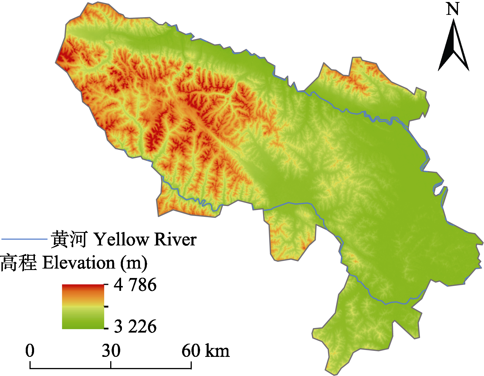
Fig. 1 Sketch map of the alpine wetland in Maqu County.
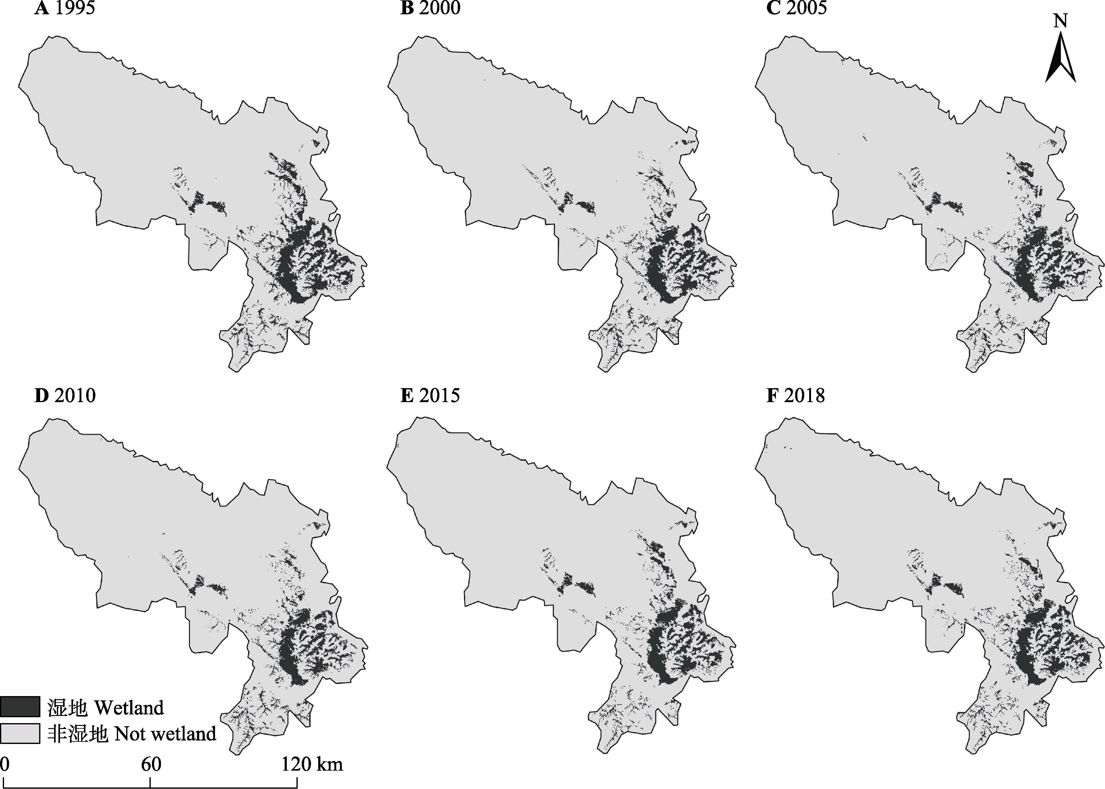
Fig. 2 Distribution of alpine wetland in Maqu County at different times.
| 1995 | 2000 | 2005 | 2010 | 2015 | 2018 | |
|---|---|---|---|---|---|---|
| Kappa系数 Kappa coefficient (%) | 88.0 | 90.0 | 86.5 | 89.5 | 92.0 | 87.0 |
| 总体精度 Accuracy | 0.80 | 0.84 | 0.81 | 0.83 | 0.87 | 0.81 |
Table 1 Kappa coefficient and overall accuracy of the classification results of remote sensing data
| 1995 | 2000 | 2005 | 2010 | 2015 | 2018 | |
|---|---|---|---|---|---|---|
| Kappa系数 Kappa coefficient (%) | 88.0 | 90.0 | 86.5 | 89.5 | 92.0 | 87.0 |
| 总体精度 Accuracy | 0.80 | 0.84 | 0.81 | 0.83 | 0.87 | 0.81 |
| 年 Year | 斑块数 Patch number | 面积 Area (hm2) | 景观比率 Landscape ratio (%) | 以1995年为基准期减少百分比 Percentage reduction by base period (1995) (%) |
|---|---|---|---|---|
| 1995 | 759 | 84 795.84 | 8.877 | - |
| 2000 | 860 | 73 574.91 | 7.702 | 13.24 |
| 2005 | 931 | 71 817.84 | 7.518 | 15.30 |
| 2010 | 1 142 | 66 115.53 | 6.922 | 22.03 |
| 2015 | 662 | 71 530.11 | 7.488 | 15.64 |
| 2018 | 786 | 74 498.13 | 7.792 | 12.14 |
Table 2 Dynamics of changes in alpine wetland in Maqu County
| 年 Year | 斑块数 Patch number | 面积 Area (hm2) | 景观比率 Landscape ratio (%) | 以1995年为基准期减少百分比 Percentage reduction by base period (1995) (%) |
|---|---|---|---|---|
| 1995 | 759 | 84 795.84 | 8.877 | - |
| 2000 | 860 | 73 574.91 | 7.702 | 13.24 |
| 2005 | 931 | 71 817.84 | 7.518 | 15.30 |
| 2010 | 1 142 | 66 115.53 | 6.922 | 22.03 |
| 2015 | 662 | 71 530.11 | 7.488 | 15.64 |
| 2018 | 786 | 74 498.13 | 7.792 | 12.14 |
| 斑块大小 Patch size (hm2) | 1995 | 2000 | 2005 | 2010 | 2015 | 2018 |
|---|---|---|---|---|---|---|
| <50 | 3 734.37 | 5 078.52 (+36.0%) | 4 307.67 (-15.2%) | 5 796.99 (+34.6%) | 4 956.39 (-14.5%) | 6 114.60 (+23.4%) |
| 50-1 000 | 17 723.34 | 21 753.54 (+22.7%) | 17 647.92 (-18.9%) | 19 600.56 (+11.1%) | 14 940.45 (-23.8%) | 18 917.73 (+26.6%) |
| 1 000-10 000 | 22 844.25 | 8 843.40 (-61.3%) | 19 358.64 (+118.9%) | 18 758.34 (-3.1%) | 27 581.04 (+47.0%) | 26 336.97 (-4.5%) |
| >10 000 | 40 493.88 | 37 899.45 (-6.4%) | 30 503.61 (-19.5%) | 21 959.64 (-28.0%) | 23 013.00 (+4.8%) | 23 128.83 (+0.5%) |
| 合计 Total | 84 795.84 | 73 574.91 (-13.2%) | 71 817.84 (-2.4%) | 66 115.53 (-7.9%) | 70 490.88 (+6.6%) | 74 498.13 (+5.7%) |
Table 3 Area components of the alpine wetland in Maqu County during 1995-2018 (hm2)
| 斑块大小 Patch size (hm2) | 1995 | 2000 | 2005 | 2010 | 2015 | 2018 |
|---|---|---|---|---|---|---|
| <50 | 3 734.37 | 5 078.52 (+36.0%) | 4 307.67 (-15.2%) | 5 796.99 (+34.6%) | 4 956.39 (-14.5%) | 6 114.60 (+23.4%) |
| 50-1 000 | 17 723.34 | 21 753.54 (+22.7%) | 17 647.92 (-18.9%) | 19 600.56 (+11.1%) | 14 940.45 (-23.8%) | 18 917.73 (+26.6%) |
| 1 000-10 000 | 22 844.25 | 8 843.40 (-61.3%) | 19 358.64 (+118.9%) | 18 758.34 (-3.1%) | 27 581.04 (+47.0%) | 26 336.97 (-4.5%) |
| >10 000 | 40 493.88 | 37 899.45 (-6.4%) | 30 503.61 (-19.5%) | 21 959.64 (-28.0%) | 23 013.00 (+4.8%) | 23 128.83 (+0.5%) |
| 合计 Total | 84 795.84 | 73 574.91 (-13.2%) | 71 817.84 (-2.4%) | 66 115.53 (-7.9%) | 70 490.88 (+6.6%) | 74 498.13 (+5.7%) |
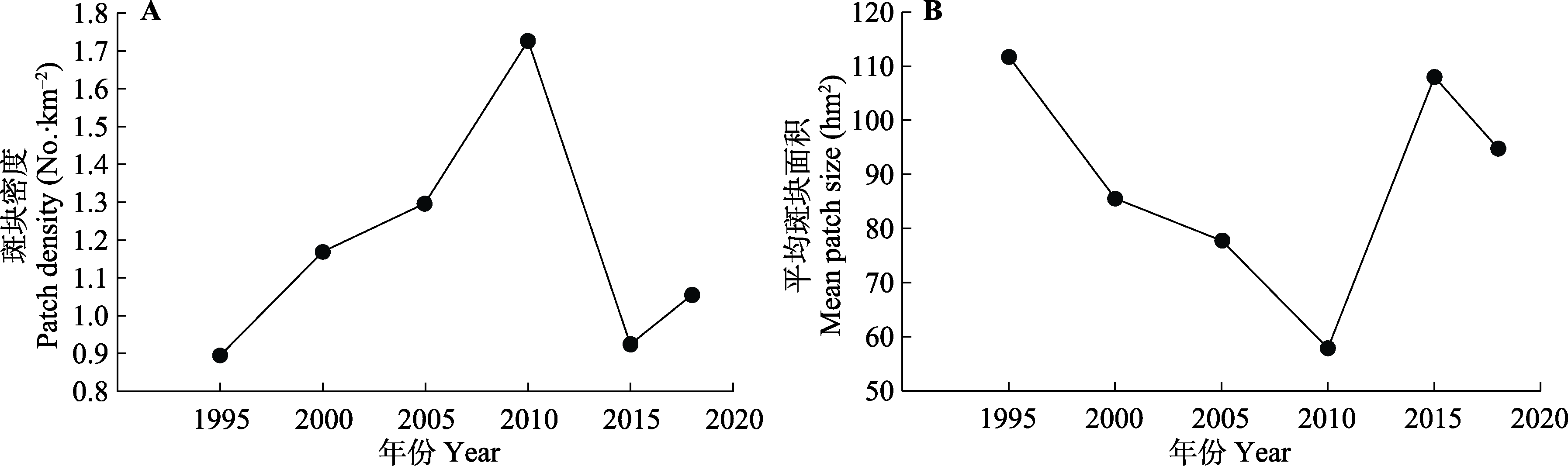
Fig. 3 Patch density (A) and mean patch size (B) of the alpine wetland in Maqu County.
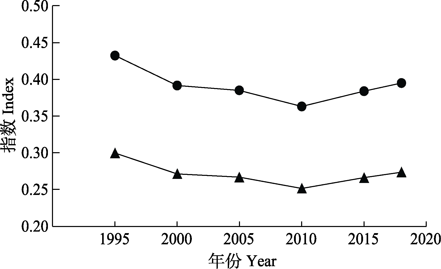
Fig. 4 Shannon’s diversity (▲) and evenness indices (●) of the alpine wetland in Maqu County.
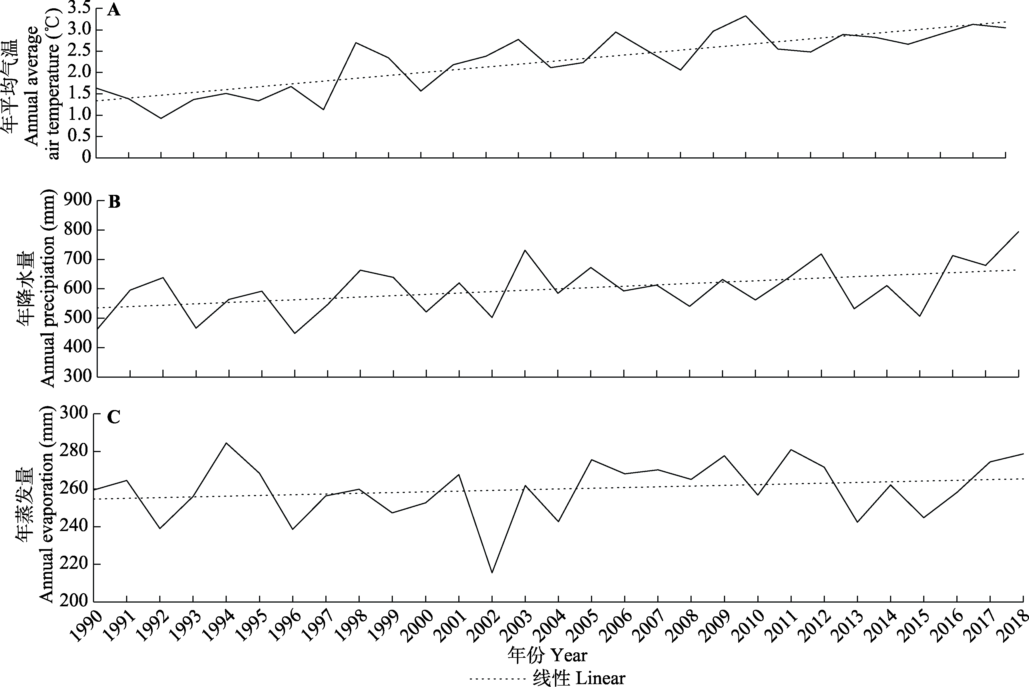
Fig. 5 Trends of annual average air temperature (A), annual precipitation (B) and annual evaporation (C) of the alpine wetland in Maqu County.
| 年 Year | 国内生产总值 Gross domestic product (104 yuan) | 第一产业值 Primary industry (104 yuan) | 第二产业值 Secondary industry (104 yuan) | 第三产业值 Tertiary industry (104 yuan) | 产业结构 Industrial structure (%) | 人口数量Population | 牲畜数量 Number of livestock (104) | 人均生产总值 Per capita GDP (104 yuan) |
|---|---|---|---|---|---|---|---|---|
| 1995 | 13 961 | 8 541 | 3 563 | 1 857 | 61/26/13 | 31 745 | 60.71 | 0.422 7 |
| 2000 | 23 751 | 10 394 | 9 620 | 3 737 | 44/41/15 | 37 100 | 68.09 | 0.632 2 |
| 2005 | 42 750 | 12 433 | 20 470 | 9 847 | 29/48/23 | 45 100 | 78.17 | 0.954 2 |
| 2010 | 95 165 | 28 269 | 34 998 | 31 898 | 30/37/33 | 51 400 | 105.10 | 1.853 3 |
| 2015 | 134 546 | 46 826 | 23 610 | 64 128 | 35/18/49 | 52 040 | 100.10 | 2.364 9 |
| 2018 | 172 886 | 77 898 | 16 615 | 78 373 | 45/10/45 | 58 200 | 94.10 | 2.878 0 |
Table 4 Total values of economic production and the structure of industrial types in the alpine wetland in Maqu County
| 年 Year | 国内生产总值 Gross domestic product (104 yuan) | 第一产业值 Primary industry (104 yuan) | 第二产业值 Secondary industry (104 yuan) | 第三产业值 Tertiary industry (104 yuan) | 产业结构 Industrial structure (%) | 人口数量Population | 牲畜数量 Number of livestock (104) | 人均生产总值 Per capita GDP (104 yuan) |
|---|---|---|---|---|---|---|---|---|
| 1995 | 13 961 | 8 541 | 3 563 | 1 857 | 61/26/13 | 31 745 | 60.71 | 0.422 7 |
| 2000 | 23 751 | 10 394 | 9 620 | 3 737 | 44/41/15 | 37 100 | 68.09 | 0.632 2 |
| 2005 | 42 750 | 12 433 | 20 470 | 9 847 | 29/48/23 | 45 100 | 78.17 | 0.954 2 |
| 2010 | 95 165 | 28 269 | 34 998 | 31 898 | 30/37/33 | 51 400 | 105.10 | 1.853 3 |
| 2015 | 134 546 | 46 826 | 23 610 | 64 128 | 35/18/49 | 52 040 | 100.10 | 2.364 9 |
| 2018 | 172 886 | 77 898 | 16 615 | 78 373 | 45/10/45 | 58 200 | 94.10 | 2.878 0 |
| 年蒸发量 Annual evaporation | 年降水量 Annual precipitation | 总人口 Total population | 大型动物存栏数 Large livestock inventory | 年平均气温 Annual average air temperature | 第一产业 Primary industry | 第二产业 Secondary industry | 第三产业 Tertiary Industry | |
|---|---|---|---|---|---|---|---|---|
| 相关系数 Correlativeness | 0.929 | 0.849 | 0.802 | 0.795 | 0.738 | 0.658 | 0.582 | 0.512 |
| 排序 Sort | 1 | 2 | 3 | 4 | 5 | 6 | 7 | 8 |
Table 5 Correlativeness and ranking of correlation between wetland area and various influencing factors in the alpine wetland in Maqu County
| 年蒸发量 Annual evaporation | 年降水量 Annual precipitation | 总人口 Total population | 大型动物存栏数 Large livestock inventory | 年平均气温 Annual average air temperature | 第一产业 Primary industry | 第二产业 Secondary industry | 第三产业 Tertiary Industry | |
|---|---|---|---|---|---|---|---|---|
| 相关系数 Correlativeness | 0.929 | 0.849 | 0.802 | 0.795 | 0.738 | 0.658 | 0.582 | 0.512 |
| 排序 Sort | 1 | 2 | 3 | 4 | 5 | 6 | 7 | 8 |
| [1] |
Bai JH,Ouyang H,Wang QG,Ding QY,Gao HF(2008).Application of Apack software on analyzing spatial pattern of wetland landscape on the Zoige Plateau.Chinese Journal of Eco-Agriculture,16, 1253-1256.
DOI URL |
| [白军红,欧阳华,王庆改,丁秋祎,高海峰(2008).基于Apack的若尔盖高原湿地景观空间格局分析.中国生态农业学报,16, 1253-1256.] | |
| [2] |
Brinson M,Malvárez AI(2002).Temperate freshwater wetlands: types, status and threats.Environmental Conservation,29, 115-133.
DOI URL |
| [3] | Chu L,Huang C,Liu GH,Liu QS(2014).Changes in ecological patterns of Maqu alpine wetland in Yellow River Source Area during 2000-2010.Progress in Geography,33, 326-335. |
| [褚琳,黄翀,刘高焕,刘庆生(2014).2000-2010年黄河源玛曲高寒湿地生态格局变化.地理科学进展,33, 326-335.] | |
| [4] | Fu YX,Zhao J,Li W(2014).Ecological sensitivity assessment of Maqu wetland in upper Yellow River.Yellow River,36(1), 65-66, 70. |
| [伏怡萱,赵军,李巍(2014).黄河上游玛曲湿地生态敏感性评估.人民黄河,36(1), 65-66, 70.] | |
| [5] | Gao YP(2019).Study on Degradation Evolution Process and Restoration Priority of Maqu Alpine Wetland in Gannan. Master degree dissertation,Beijing Forestry University, Beijing. |
| [高跃鹏(2019).甘南玛曲高寒湿地退化演化过程及恢复优先性研究. 硕士学位论文,北京林业大学, 北京.] | |
| [6] | Guo J,Li GP(2007).Climate change in Zoigê plateau marsh wetland and its impact on wetland degradation.Plateau Meteorology,26, 422-428. |
| [郭洁,李国平(2007).若尔盖气候变化及其对湿地退化的影响.高原气象,26, 422-428.] | |
| [7] | He JH(2016).Monitoring Wetland Change and Driving Factor Analysis from 2000 to 2014 in Zoigê. Master degree dissertation,Chengdu University of Technology, Chengdu. |
| [何菊红(2016).2000-2014年若尔盖湿地变化监测及驱动因子分析. 硕士学位论文,成都理工大学, 成都.] | |
| [8] | Hu XK,Wei HD,Chen F,Xu XY,Zhou JH,Tang JN(2012).Dynamic changes of alpine-cold wetland landscape in Maqu County in the Yellow River source region.Journal of Southwest Forestry University,32(6), 43-47. |
| [胡小柯,魏怀东,陈芳,徐先英,周坚华,唐进年(2012).黄河源区玛曲县高寒湿地景观动态变化.西南林业大学学报,32(6), 43-47.] | |
| [9] | Huang Q,Lan L,Yang WN,Deng DZ,Yan WX(2014).Analysis of landscape pattern changes of alpine wetland in Zoigê.Journal of Sichuan Forestry Science and Technology,35(6), 60-63. |
| [黄茜,蓝岚,杨武年,邓东周,鄢武先(2014).若尔盖高寒湿地景观格局变化分析.四川林业科技,35(6), 60-63.] | |
| [10] |
Junk WJ,An SQ,Finlayson CM,Gopal B,Květ J,Mitchell SA,Mitsch WJ,Robarts RD(2013).Current state of knowledge regarding the world’s wetlands and their future under global climate change: a synthesis.Aquatic Sciences,75, 151-167.
DOI URL |
| [11] | Li WL,Wang J,Guo SM,Wang Y(2009).Dynamic change of marsh landscape patterns and its driving forces in Maqu.Pratacultural Science,26(8), 57-62. |
| [李文龙,王晶,郭述茂,王莺(2009).玛曲沼泽湿地景观格局变化研究及驱动力分析.草业科学,26(8), 57-62.] | |
| [12] | Mitra S,Wassmann R,Vlek PLG(2005).An appraisal of global wetland area and its organic carbon stock.Current Science,88, 25-35. |
| [13] | Peng F(2012).Soff Moisture Quantitative Study of the Nanhui Tidal Flat in the Yangtze River Estuary. Master degree dissertation,Shanghai Ocean University, Shanghai. |
| [彭飞(2012).长江口南汇潮滩土壤湿度遥感研究. 硕士学位论文,上海海洋大学, 上海.] | |
| [14] | Qin DM,Feng J(2014).Study on natural grassland production potential and livestock capacity in Gannan.China Herbivore Science,34(5), 40-42. |
| [秦冬梅,冯今(2014).甘南天然草地生产潜力与载畜量研究.中国草食动物科学,34(5), 40-42.] | |
| [15] |
Verhoeven JTA,Arheimer B,Yin CQ,Hefting MM(2006).Regional and global concerns over wetlands and water quality.Trends in Ecology & Evolution,21, 96-103.
DOI URL |
| [16] | Wang YS,Xia ST(2018).A survey of random forests algorithms.Information and Communications Technologies,12, 49-55. |
| [王奕森,夏树涛(2018).集成学习之随机森林算法综述.信息通信技术,12, 49-55.] | |
| [17] | Wolfson L,Mokma D,Schultink G,Dersch E(2002).Development and use of a wetlands information system for assessing wetland functions.Lakes & Reservoirs: Research & Management,7, 207-216. |
| [18] | Wu JG(2007).Landscape Ecology. 2nd ed.Higher Education Press,Beijing. 106-107. |
| [邬建国(2007).景观生态学. 2版.高等教育出版社,北京. 106-107.] | |
| [19] | Xing Y(2015).Spatial responses of wetland change to climate in 32 years in Qinghai-Tibet Plateau.Remote Sensing for Land & Resources,27(3), 99-107. |
| [邢宇(2015).青藏高原32年湿地对气候变化的空间响应.国土资源遥感,27(3), 99-107.] | |
| [20] | Yu C(2017). Sustainable Development of the Tibetan Plateau Based on the Energy Ecological Footprint Model—Taking Qinghai and Tibet as an Example. Master degree dissertation,Lanzhou University, Lanzhou. |
| [余翠(2017).基于能值生态足迹模型的青藏高原地区可持续发展研究——以青海省、西藏自治区为例. 硕士学位论文,兰州大学, 兰州.] | |
| [21] | Zhang ZD(2012).Dynamic Monitoring of Maqu Wetland Based on 3S Technology. Master degree dissertation,Lanzhou University, Lanzhou. |
| [张志达(2012).基于3S的玛曲湿地动态监测研究. 硕士学位论文,兰州大学, 兰州.] | |
| [22] | Zhao ZL,Zhang YL,Liu LS,Liu FG,Zhang HF(2014).Advances in research on wetlands of the Tibetan Plateau.Progress in Geography,33, 1218-1230. |
| [赵志龙,张镱锂,刘林山,刘峰贵,张海峰(2014).青藏高原湿地研究进展.地理科学进展,33, 1218-1230.] | |
| [23] | Zhen S,Suolang D,Dong LQ,Yao PJ,Zheng RM(2016).Analysis on climate change characteristics of Zoige Plateau during 1967-2014.Journal of Southwest Forestry University,36(5), 138-143. |
| [甄硕,索朗夺尔基,董李勤,姚鹏举,郑茹敏(2016).若尔盖高原1967-2014年气候变化特征分析.西南林业大学学报,36(5), 138-143.] | |
| [24] | Zhou ZL,Sha JM,Fan YX,Shuai C,Gao S(2020).Remote sensing land usage classification and landscape pattern analysis based on random forest.Computer Systems & Applications,29(2), 40-48. |
| [周正龙,沙晋明,范跃新,帅晨,高尚(2020).基于随机森林的遥感土地利用分类及景观格局分析.计算机系统应用,29(2), 40-48.] | |
| [25] | Zuo XQ,LI XY,Liu HP(2020).Research on urban land cover classification based on random forest algorithm.Journal of the Hebei Academy of Sciences,37(1), 8-16. |
| [左晓庆,李潇雨,刘怀鹏(2020).基于随机森林算法的城区土地覆盖分类研究.河北省科学院学报,37(1), 8-16.] |
| Viewed | ||||||
|
Full text |
|
|||||
|
Abstract |
|
|||||
Copyright © 2026 Chinese Journal of Plant Ecology
Tel: 010-62836134, 62836138, E-mail: apes@ibcas.ac.cn, cjpe@ibcas.ac.cn
![]()