
Chin J Plant Ecol ›› 2022, Vol. 46 ›› Issue (10): 1234-1250.DOI: 10.17521/cjpe.2022.0104 cstr: 32100.14.cjpe.2022.0104
• Research Articles • Previous Articles Next Articles
ZHAO Yan-Ping1, WANG Zhong-Wu1, WENDU Rigen3, ZHAO Yu-Jin2,*( ), BAI Yong-Fei2,*()
Received:2022-03-23
Accepted:2022-07-06
Online:2022-10-20
Published:2022-09-28
Contact:
ZHAO Yu-Jin,BAI Yong-Fei
Supported by:ZHAO Yan-Ping, WANG Zhong-Wu, WENDU Rigen, ZHAO Yu-Jin, BAI Yong-Fei. Remotely sensed monitoring method of grassland plant functional diversity and its relationship with productivity based on Sentinel-2 satellite data[J]. Chin J Plant Ecol, 2022, 46(10): 1234-1250.
Add to citation manager EndNote|Ris|BibTeX
URL: https://www.plant-ecology.com/EN/10.17521/cjpe.2022.0104
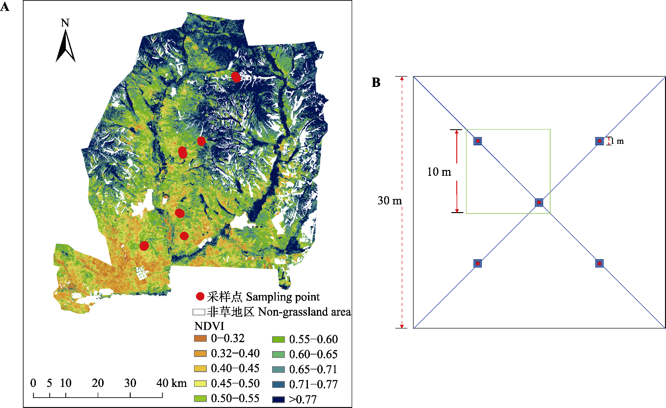
Fig. 1 Location of the study area (A) and sample settings (B) across the meadow steppe in the Ulgai Management Area of Xilin Gol League in Nei Mongol. In B, blue boxes represent 1 m × 1 m small sample squares, red boxes represent the area of 1/4 of the center of small sample squares, and the green box represents the composition of 10 m × 10 m sample square. NDVI, normalized difference vegetation index.
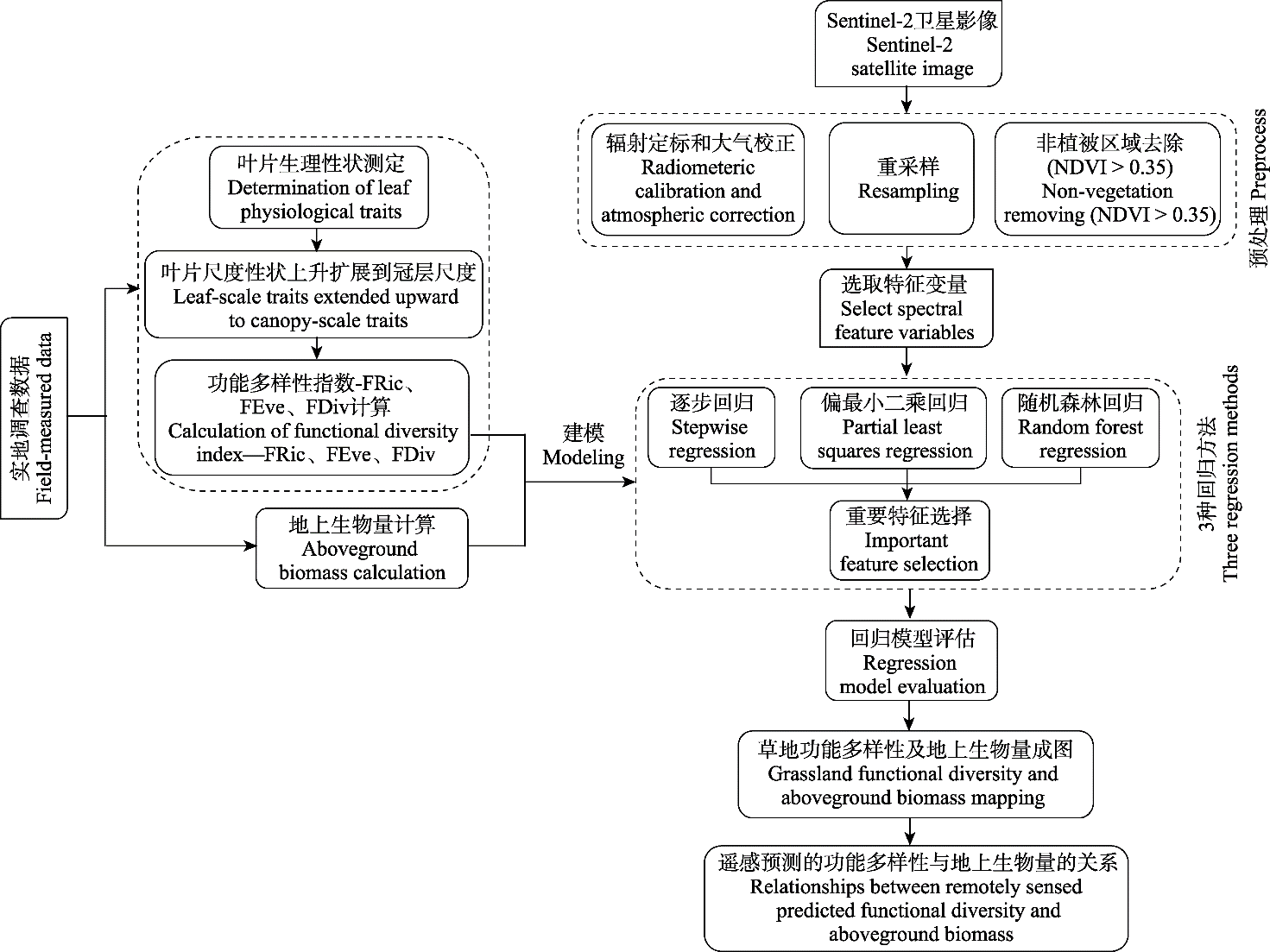
Fig. 2 Flow chart of the research method. FDiv, functional diversity; FEve, functional evenness; FRic, functional richness; NDVI, normalized difference vegetation index.
| 植被指数 Vegetation index | 计算公式 Calculate formula | Sentinel-2波段 Sentinel-2 band used | 参考文献 Reference |
|---|---|---|---|
| TCARI | 3[(R699.19 - R668.98) - 0.2(R699.19 - R550.67)(R699.19/R668.98)] | B3, B4, B5 | Kim et al., |
| OSAVI | (1 + 0.16)(R750 - R705)/(R750 + R705 + 0.16) | B5, B6 | Wu et al., |
| OSAVI2 | (1 + 0.16) (R800 - R670)/(R800 + R670 + 0.16) | B4, B7 | Rondeaux et al., |
| D | R730/R706 | B5, B6 | Zarco-Tejada et al., |
| Datt | (R850 - R710)/(R850 - R680) | B4, B5, B8 | Datt, |
| Datt2 | R850/R710 | B5, B8 | Datt, |
| Gitelson | 1/R700 | B5 | Gitelson et al., |
| SR | R750/R700 | B5, B6 | Gitelson & Merzlyak, |
| SR2 | R700/R670 | B4, B5 | McMurtrey III et al., |
| MSI | R1600/R819 | B8, B11 | Hunt Jr & Rock, |
| NDVI705 | (R750 - R705)/( R750 + R705) | B5, B6 | Sims & Gamon, |
| CRI1 | 1/R510 - 1/R550 | B2, B3 | Gitelson et al., |
| CRI2 | 1/R510 - 1/R700 | B2, B5 | Gitelson et al., |
| ARI1 | 1/R550 - 1/R700 | B3, B5 | Sims & Gamon, |
| ARI2 | R800(1/R550 - 1/R700) | B3, B5, B7 | Gitelson et al., |
| NDVI | (R842 - R665)/(R842 + R665) | B4, B8 | Huete et al., |
| GNDVI | (R783 - R560)/(R783 + R560) | B3, B7 | Rozenstein et al., |
| TNDVI | [(R842 - R665)/(R842 + R665) + 0.5]0.5 | B4, B8 | Rozenstein et al., |
| WDVI | R842 - 0.5R665 | B4, B8 | Rozenstein et al., |
| NDI45 | (R705 - R665)/(R705 + R665) | B4, B5 | Delegido et al., |
| SAVI | (1 + 0.5) × (R799.09 - R680.045)/(R799.09 + R680.045 + 0.5) | B4, B7 | Huete, |
| SAVI2 | R799.09/(R680.045 + b/a) (a = 0.97, b = 0.08) | B4, B7 | Major et al., |
| ARVI | ARVI = (R799.09 -R680.045 + R444.5 + R680.045)/(R799.09 + R680.045 - R444.5 - R680.045) | B1, B4, B7 | Kaufman & Tanre, |
| SARVI | RB = R680.045 - (R444.5 - R680.045) SARVI = (1 + 0.5)(R799.09 -R680.045 + R444.5 + R680.045)/(R799.09 + R680.045 - R444.5 - R680.045 + 0.5) | B1, B4, B7 | Kaufman & Tanre, |
| EVI | 2.5(R799.09 - R680.045)/(R799.09 + 6R680.045 - 7.5R444.5 + 1) | B1, B4, B7 | Huete et al., |
| IRECI | (R783 - R665)/(R705/R740) | B4, B5, B6, B7 | Frampton et al., |
| IPVI | R842/(R842 + R665) | B4, B8 | Rozenstein et al., |
| PSSRA | R783/R665 | B4, B7 | Rozenstein et al., |
| RVI | R842/R665 | B4, B8 | Rozenstein et al., |
| mNDVI705 | (R750 - R705)/( R750 + R705 - 2R445) | B1, B5, B6 | Datt, |
| mSR705 | (R750 - R445)/( R705 + R445) | B1, B6 | Datt, |
| SIPI | (R800 - R445)/( R800 - R680) | B1, B7 | Penuelas et al., |
| NDWI | (R865 - R1614)/( R865 - R1614) | B8A, B11 | McFeeters, |
Table 1 Calculating formula of vegetation index
| 植被指数 Vegetation index | 计算公式 Calculate formula | Sentinel-2波段 Sentinel-2 band used | 参考文献 Reference |
|---|---|---|---|
| TCARI | 3[(R699.19 - R668.98) - 0.2(R699.19 - R550.67)(R699.19/R668.98)] | B3, B4, B5 | Kim et al., |
| OSAVI | (1 + 0.16)(R750 - R705)/(R750 + R705 + 0.16) | B5, B6 | Wu et al., |
| OSAVI2 | (1 + 0.16) (R800 - R670)/(R800 + R670 + 0.16) | B4, B7 | Rondeaux et al., |
| D | R730/R706 | B5, B6 | Zarco-Tejada et al., |
| Datt | (R850 - R710)/(R850 - R680) | B4, B5, B8 | Datt, |
| Datt2 | R850/R710 | B5, B8 | Datt, |
| Gitelson | 1/R700 | B5 | Gitelson et al., |
| SR | R750/R700 | B5, B6 | Gitelson & Merzlyak, |
| SR2 | R700/R670 | B4, B5 | McMurtrey III et al., |
| MSI | R1600/R819 | B8, B11 | Hunt Jr & Rock, |
| NDVI705 | (R750 - R705)/( R750 + R705) | B5, B6 | Sims & Gamon, |
| CRI1 | 1/R510 - 1/R550 | B2, B3 | Gitelson et al., |
| CRI2 | 1/R510 - 1/R700 | B2, B5 | Gitelson et al., |
| ARI1 | 1/R550 - 1/R700 | B3, B5 | Sims & Gamon, |
| ARI2 | R800(1/R550 - 1/R700) | B3, B5, B7 | Gitelson et al., |
| NDVI | (R842 - R665)/(R842 + R665) | B4, B8 | Huete et al., |
| GNDVI | (R783 - R560)/(R783 + R560) | B3, B7 | Rozenstein et al., |
| TNDVI | [(R842 - R665)/(R842 + R665) + 0.5]0.5 | B4, B8 | Rozenstein et al., |
| WDVI | R842 - 0.5R665 | B4, B8 | Rozenstein et al., |
| NDI45 | (R705 - R665)/(R705 + R665) | B4, B5 | Delegido et al., |
| SAVI | (1 + 0.5) × (R799.09 - R680.045)/(R799.09 + R680.045 + 0.5) | B4, B7 | Huete, |
| SAVI2 | R799.09/(R680.045 + b/a) (a = 0.97, b = 0.08) | B4, B7 | Major et al., |
| ARVI | ARVI = (R799.09 -R680.045 + R444.5 + R680.045)/(R799.09 + R680.045 - R444.5 - R680.045) | B1, B4, B7 | Kaufman & Tanre, |
| SARVI | RB = R680.045 - (R444.5 - R680.045) SARVI = (1 + 0.5)(R799.09 -R680.045 + R444.5 + R680.045)/(R799.09 + R680.045 - R444.5 - R680.045 + 0.5) | B1, B4, B7 | Kaufman & Tanre, |
| EVI | 2.5(R799.09 - R680.045)/(R799.09 + 6R680.045 - 7.5R444.5 + 1) | B1, B4, B7 | Huete et al., |
| IRECI | (R783 - R665)/(R705/R740) | B4, B5, B6, B7 | Frampton et al., |
| IPVI | R842/(R842 + R665) | B4, B8 | Rozenstein et al., |
| PSSRA | R783/R665 | B4, B7 | Rozenstein et al., |
| RVI | R842/R665 | B4, B8 | Rozenstein et al., |
| mNDVI705 | (R750 - R705)/( R750 + R705 - 2R445) | B1, B5, B6 | Datt, |
| mSR705 | (R750 - R445)/( R705 + R445) | B1, B6 | Datt, |
| SIPI | (R800 - R445)/( R800 - R680) | B1, B7 | Penuelas et al., |
| NDWI | (R865 - R1614)/( R865 - R1614) | B8A, B11 | McFeeters, |
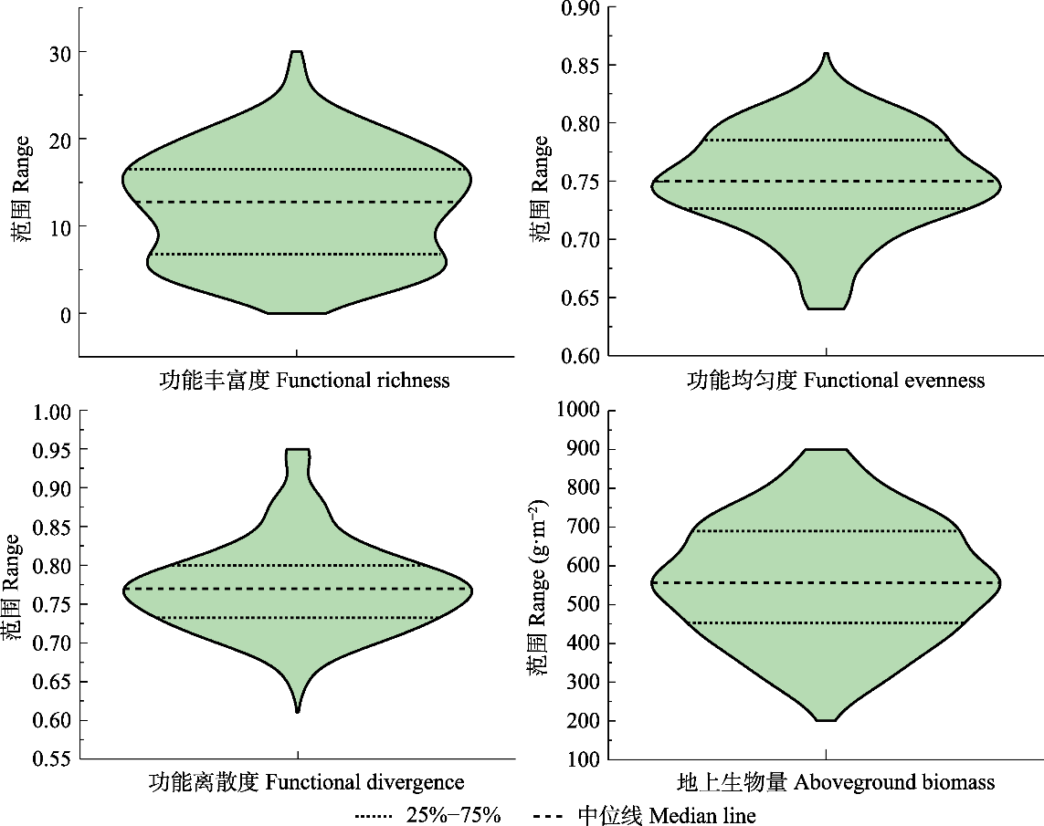
Fig. 3 Measured functional diversity and aboveground biomass.
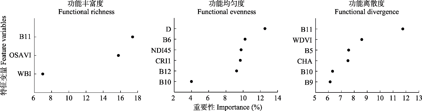
Fig. 4 Importance ranking of functional diversity feature variables. B5, B6, B9, B10, B11, B12 means bands 5, 6, 9, 10, 11, 12; CHA, convex hull area; CRI1, carotenoid reflectance index 1; D, double-peak optical index; NDI45, normalized difference index 45; OSAVI, optimized soil-adjusted vegetation index; WBI, water band index; WDVI, weighted differential vegetation index.
| 功能多样性指数 Functional diversity index | 逐步回归 Stepwise regression | 随机森林回归 Random forest regression | 偏最小二乘回归 Partial least squares regression | |||
|---|---|---|---|---|---|---|
| R2 | RMSE | R2 | RMSE | R2 | RMSE | |
| FRic | 0.52 | 4.51 | 0.40 | 5.18 | 0.36 | 4.88 |
| FEve | 0.43 | 0.03 | 0.32 | 0.04 | 0.35 | 0.03 |
| FDiv | 0.54 | 0.04 | 0.56 | 0.04 | 0.61 | 0.04 |
Table 2 Validation accuracy of the three regression methods
| 功能多样性指数 Functional diversity index | 逐步回归 Stepwise regression | 随机森林回归 Random forest regression | 偏最小二乘回归 Partial least squares regression | |||
|---|---|---|---|---|---|---|
| R2 | RMSE | R2 | RMSE | R2 | RMSE | |
| FRic | 0.52 | 4.51 | 0.40 | 5.18 | 0.36 | 4.88 |
| FEve | 0.43 | 0.03 | 0.32 | 0.04 | 0.35 | 0.03 |
| FDiv | 0.54 | 0.04 | 0.56 | 0.04 | 0.61 | 0.04 |
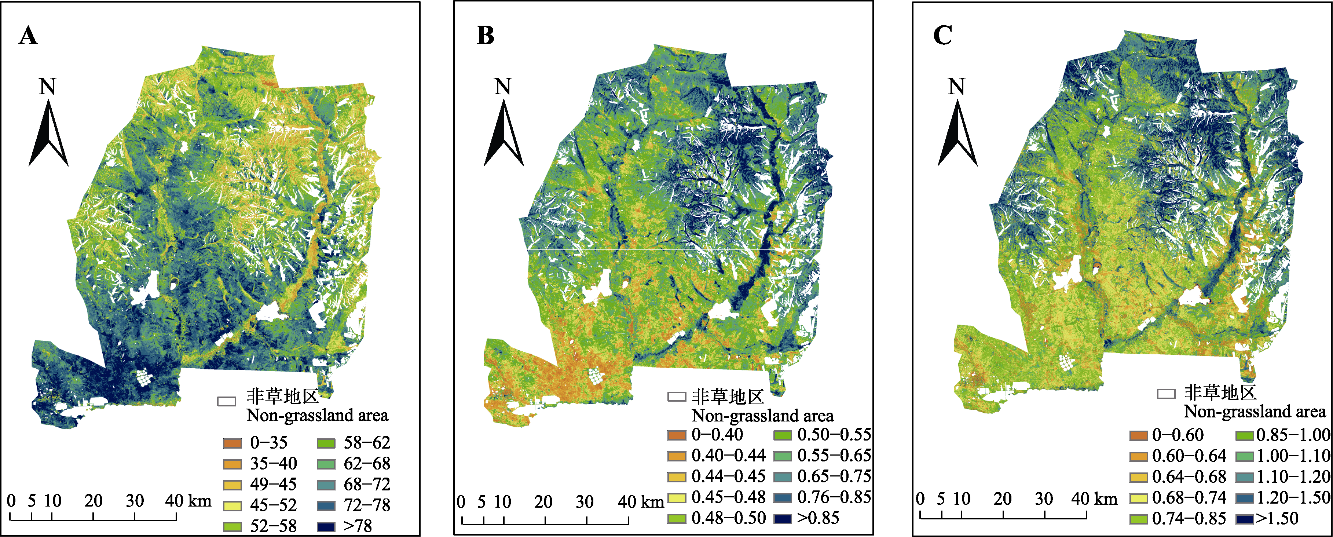
Fig. 5 Maps of plant functional diversity metrics in the Ulgai Management Area. A, Functional richness. B, Functional evenness. C, Functional divergence.
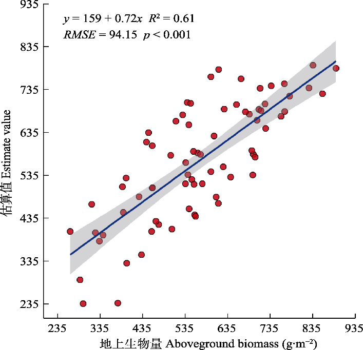
Fig. 6 Validation of the remotely-sensed aboveground biomass based on field-measured data. Solid and dashed lines depict the linear regression model and the 1:1 line, respectively. All regression analyses were statistically significant (p < 0.001). RMSE is root mean square error.
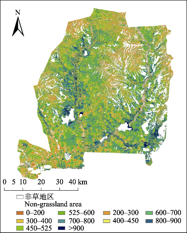
Fig. 7 Distribution of the remotely-sensed aboveground biomass (g·m-2) in the Ulgai Management Area.
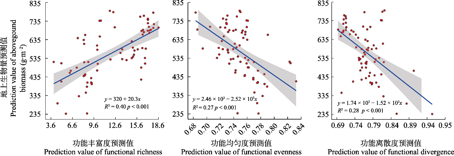
Fig. 8 Relationships between remotely-sensed functional diversity and aboveground biomass.
| [1] |
Asner GP, Martin RE. (2008). Spectral and chemical analysis of tropical forests: scaling from leaf to canopy levels. Remote Sensing of Environment, 112, 3958-3970.
DOI URL |
| [2] |
Asner GP, Martin RE, Knapp DE, Tupayachi R, Anderson CB, Sinca F, Vaughn NR, Llactayo W. (2017). Airborne laser-guided imaging spectroscopy to map forest trait diversity and guide conservation. Science, 355, 385-388.
DOI PMID |
| [3] |
Bai YF, Han XG, Wu JG, Chen ZZ, Li LH. (2004). Ecosystem stability and compensatory effects in the Inner Mongolia grassland. Nature, 431, 181-184.
DOI URL |
| [4] |
Bai YF, Wu JG, Pan QM, Huang JH, Wang QB, Li FS, Buyantuyev A, Han XG. (2007). Positive linear relationship between productivity and diversity: evidence from the Eurasian Steppe. Journal of Applied Ecology, 44, 1023-1034.
DOI URL |
| [5] |
Bernhardt RM, Roemermann C, Sperlich S, Schmidt W. (2011). Explaining grassland biomass—The contribution of climate, species and functional diversity depends on fertilization and mowing frequency. Journal of Applied Ecology, 48, 1088-1097.
DOI URL |
| [6] |
Blackburn GA. (2007). Hyperspectral remote sensing of plant pigments. Journal of Experimental Botany, 58, 855-867.
DOI PMID |
| [7] |
Botta-Dukát Z. (2005). Raoʼs quadratic entropy as a measure of functional diversity based on multiple traits. Journal of Vegetation Science, 16, 533-540.
DOI URL |
| [8] |
Breiman L. (2001). Random forests. Machine Learning, 45, 5-32.
DOI URL |
| [9] |
Cadotte MW, Carscadden K, Mirotchnick N. (2011). Beyond species: functional diversity and the maintenance of ecological processes and services. Journal of Applied Ecology, 48, 1079-1087.
DOI URL |
| [10] |
Cutler A, Stevens JR. (2006). Random forests for microarrays. Methods in Enzymology, 411, 422-432.
PMID |
| [11] | Cutler A, Zhao G. (2001). PERT—Perfect random tree ensembles. Computer Science and Statistics, 1-8. |
| [12] |
da Silveira Pontes L, Louault F, Carrère P, Maire V, Andueza D, Soussana JF. (2010). The role of plant traits and their plasticity in the response of pasture grasses to nutrients and cutting frequency. Annals of Botany, 105, 957-965.
DOI PMID |
| [13] |
Dahlin KM, Asner GP, Field CB. (2013). Environmental and community controls on plant canopy chemistry in a Mediterranean-type ecosystem. Proceedings of the National Academy of Sciences of the United States of America, 110, 6895-6900.
DOI PMID |
| [14] |
Datt B. (1999). A new reflectance index for remote sensing of chlorophyll content in higher plants: tests using Eucalyptus leaves. Journal of Plant Physiology, 154, 30-36.
DOI URL |
| [15] |
Delegido J, Verrelst J, Alonso L, Moreno J. (2011). Evaluation of Sentinel-2 red-edge bands for empirical estimation of green LAI and chlorophyll content. Sensors, 11, 7063-7081.
DOI PMID |
| [16] |
Deng S, Katoh M, Yu X, Hyyppa J, Gao T. (2016). Comparison of tree species classifications at the individual tree level by combining ALS data and RGB images using different algorithms. Remote Sensing, 8, 1034. DOI: 10.3390/rs8121034.
DOI |
| [17] |
Díaz S, Cabido M. (2001). Vive la différence: plant functional diversity matters to ecosystem processes. Trends in Ecology & Evolution, 16, 646-655.
DOI URL |
| [18] |
Díaz S, Hodgson JG, Thompson K, Cabido M, Cornelissen JHC, Jalili A, Montserrat-Martí G, Grime JP, Zarrinkamar F, Asri Y, Band SR, Basconcelo S, Castro-Díez P, Funes G, Hamzehee B, et al. (2004). The plant traits that drive ecosystems: evidence from three continents. Journal of Vegetation Science, 15, 295-304.
DOI URL |
| [19] |
Dou ZG, Li YZ, Cui LJ, Pan X, Ma QF, Huang YL, Lei YR, Li J, Zhao XS, Li W. (2020). Hyperspectral inversion of Suaeda salsa biomass under different types of human activity in Liaohe Estuary wetland in north-eastern China. Marine and Freshwater Research, 71, 482-492.
DOI URL |
| [20] |
Durán SM, Martin RE, Díaz S, Maitner BS, Malhi Y, Salinas N, Shenkin A, Silman MR, Wieczynski DJ, Asner GP, Bentley LP, Savage VM, Enquist BJ. (2019). Informing trait-based ecology by assessing remotely sensed functional diversity across a broad tropical temperature gradient. Science Advances, 5, eaaw8114. DOI: 10.1126/sciadv.aaw8114.
DOI |
| [21] |
Edwards JA, Santos-Medellin CM, Liechty ZS, Nguyen B, Lurie E, Eason S, Phillips G, Sundaresan V. (2018). Compositional shifts in root-associated bacterial and archaeal microbiota track the plant life cycle in field-grown rice. PLOS Biology, 16, e2003862. DOI: 10.1371/journal.pbio.2003862.
DOI |
| [22] |
Farifteh J, van der Meer F, Atzberger C, Carranza EJM. (2007). Quantitative analysis of salt-affected soil reflectance spectra: a comparison of two adaptive methods (PLSR and ANN). Remote Sensing of Environment, 110, 59-78.
DOI URL |
| [23] |
Frampton WJ, Dash J, Watmough G, Milton EJ. (2013). Evaluating the capabilities of Sentinel-2 for quantitative estimation of biophysical variables in vegetation. ISPRS Journal of Photogrammetry and Remote Sensing, 82, 83-92.
DOI URL |
| [24] |
Fyllas NM, Bentley LP, Shenkin A, Asner GP, Atkin OK, Díaz S, Enquist BJ, Farfan-Rios W, Gloor E, Guerrieri R, Huasco WH, Ishida Y, Martin RE, Meir P, Phillips O, et al. (2017). Solar radiation and functional traits explain the decline of forest primary productivity along a tropical elevation gradient. Ecology Letters, 20, 730-740.
DOI PMID |
| [25] |
Genuer R, Poggi JM, Tuleau-Malot C. (2010). Variable selection using random forests. Pattern Recognition Letters, 31, 2225-2236.
DOI URL |
| [26] |
Gholizadeh H, Gamon JA, Zygielbaum AI, Wang R, Schweiger AK, Cavender-Bares J. (2018). Remote sensing of biodiversity: soil correction and data dimension reduction methods improve assessment of α-diversity (species richness) in prairie ecosystems. Remote Sensing of Environment, 206, 240-253.
DOI URL |
| [27] | Gillison AN. (2013). Plant functional types and traits at the community ecosystem and world level//van der Maarel E, Franklin J. Vegetation Ecology. John Wiley & Sons, Oxford. 347-386. |
| [28] |
Gitelson AA, Buschmann C, Lichtenthaler HK. (1999). The chlorophyll fluorescence ratio F735/F700 as an accurate measure of the chlorophyll content in plants. Remote Sensing of Environment, 69, 296-302.
DOI URL |
| [29] |
Gitelson AA, Gritz Y, Merzlyak MN. (2003). Relationships between leaf chlorophyll content and spectral reflectance and algorithms for non-destructive chlorophyll assessment in higher plant leaves. Journal of Plant Physiology, 160, 271-282.
DOI PMID |
| [30] |
Gitelson AA, Merzlyak MN. (1997). Remote estimation of chlorophyll content in higher plant leaves. International Journal of Remote Sensing, 18, 2691-2697.
DOI URL |
| [31] |
Gitelson AA, Zur Y, Chivkunova OB, Merzlyak MN. (2002). Assessing carotenoid content in plant leaves with reflectance spectroscopy. Photochemistry and Photobiology, 75, 272-281.
DOI PMID |
| [32] |
Grime JP. (1998). Benefits of plant diversity to ecosystems: immediate, filter and founder effects. Journal of Ecology, 86, 902-910.
DOI URL |
| [33] | Han TT, Tang X, Ren H, Wang J, Liu N, Guo QF. (2021). Community/ecosystem functional diversity: measurements and development. Acta Ecologica Sinica, 41, 3286-3295. |
| [韩涛涛, 唐玄, 任海, 王俊, 刘楠, 郭勤峰 (2021). 群落/生态系统功能多样性研究方法及展望. 生态学报, 41, 3286-3295.] | |
| [34] |
Homolová L, Malenovský Z, Clevers JGPW, García-Santos G, Schaepman ME. (2013). Review of optical-based remote sensing for plant trait mapping. Ecological Complexity, 15, 1-16.
DOI URL |
| [35] |
Hoover DL, Knapp AK, Smith MD. (2014). Resistance and resilience of a grassland ecosystem to climate extremes. Ecology, 95, 2646-2656.
DOI URL |
| [36] |
Huete AR. (1988). A soil-adjusted vegetation index (SAVI). Remote Sensing of Environment, 25, 295-309.
DOI URL |
| [37] |
Huete AR, Liu HQ, Batchily K, van Leeuwen W. (1997). A comparison of vegetation indices over a global set of TM images for EOS-MODIS. Remote Sensing of Environment, 59, 440-451.
DOI URL |
| [38] |
Hunt Jr ER, Rock BN. (1989). Detection of changes in leaf water content using Near- and Middle-Infrared reflectances. Remote Sensing of Environment, 30, 43-54.
DOI URL |
| [39] |
Kassen R, Buckling A, Bell G, Rainey PB. (2000). Diversity peaks at intermediate productivity in a laboratory microcosm. Nature, 406, 508-512.
DOI URL |
| [40] |
Kaufman YJ, Tanre D. (1992). Atmospherically resistant vegetation index (ARVI) for EOS-MODIS. IEEE Transactions on Geoscience and Remote Sensing, 30, 261-270.
DOI URL |
| [41] | Kim MS, Daughtry C, Chappelle EW, McMurtrey III JE, Walthall CL. (1994). The use of high spectral resolution bands for estimating absorbed photosynthetically active radiation// ISPRS Sixth International Colloquium on Physical Measurements and Signatures in Remote Sensing. 17-21. |
| [42] |
Kong B, Yu H, Du RX, Wang Q. (2019). Quantitative estimation of biomass of alpine grasslands using hyperspectral remote sensing. Rangeland Ecology & Management, 72, 336-346.
DOI URL |
| [43] |
Laliberté E, Legendre P. (2010). A distance-based framework for measuring functional diversity from multiple traits. Ecology, 91, 299-305.
PMID |
| [44] | Lepš J, de Bello F, Lavorel S, Berman S. (2006). Quantifying and interpreting functional diversity of natural communities: practical considerations matter. Preslia, 78, 481-501. |
| [45] |
Li XG, Zhu ZH, Zhou XS, Yuan FR, Fan RJ, Xu ML. (2011). Effects of clipping, fertilizing and watering on the relationship between species diversity, functional diversity and primary productivity in alpine meadow of China. Chinese Journal of Plant Ecology, 35, 1136-1147.
DOI URL |
|
[李晓刚, 朱志红, 周晓松, 袁芙蓉, 樊瑞俭, 许曼丽 (2011). 刈割、施肥和浇水对高寒草甸物种多样性、功能多样性与初级生产力关系的影响. 植物生态学报, 35, 1136-1147.]
DOI |
|
| [46] |
Liu XJ, Ma KP. (2015). Plant functional traits—Concepts, applications and future directions. Scientia Sinica Vitae, 45, 325-339.
DOI URL |
| [刘晓娟, 马克平 (2015). 植物功能性状研究进展. 中国科学: 生命科学, 45, 325-339.] | |
| [47] |
Loreau M, Naeem S, Inchausti P, Bengtsson J, Grime JP, Hector A, Hooper DU, Huston MA, Raffaelli D, Schmid B, Tilman D, Wardle DA. (2001). Biodiversity and ecosystem functioning: current knowledge and future challenges. Science, 294, 804-808.
DOI PMID |
| [48] | Ma WJ. (2014). The Relationship Between Plant Functional Diversity and Primary Productivity in Desert Steppe of Inner Mongolia. Master degree desertation, Inner Mongolia University, Hohhot. |
| [马文静 (2014). 内蒙古荒漠草原植物功能多样性与初级生产力的关系. 硕士学位论文, 内蒙古大学, 呼和浩特.] | |
| [49] |
Major DJ, Baret F, Guyot G. (1990). A ratio vegetation index adjusted for soil brightness. International Journal of Remote Sensing, 11, 727-740.
DOI URL |
| [50] |
Mallinis G, Chrysafis I, Korakis G, Pana E, Kyriazopoulos AP. (2020). A random forest modelling procedure for a multi-sensor assessment of tree species diversity. Remote Sensing, 12, 1210. DOI: 10.3390/rs12071210.
DOI |
| [51] |
Marron N, Villar M, Dreyer E, Delay D, Boudouresque E, Petit JM, Delmotte FM, Guehl JM, Brignolas F. (2005). Diversity of leaf traits related to productivity in 31 Populus deltoides × Populus nigra clones. Tree Physiology, 25, 425-435.
DOI URL |
| [52] |
Mason NWH, MacGillivray K, Steel JB, Wilson JB. (2003). An index of functional diversity. Journal of Vegetation Science, 14, 571-578.
DOI URL |
| [53] |
Mason NWH, Mouillot D, Lee WG, Wilson JB. (2005). Functional richness, functional evenness and functional divergence: the primary components of functional diversity. Oikos, 111, 112-118.
DOI URL |
| [54] |
McFeeters SK. (1996). The use of the normalized difference water index (NDWI) in the delineation of open water features. International Journal of Remote Sensing, 17, 1425-1432.
DOI URL |
| [55] |
McMurtrey III JE, Chappelle EW, Kim MS, Meisinger JJ, Corp LA. (1994). Distinguishing nitrogen fertilization levels in field corn (Zea mays L.) with actively induced fluorescence and passive reflectance measurements. Remote Sensing of Environment, 47, 36-44.
DOI URL |
| [56] |
Mouillot D, Graham NAJ, Villéger S, Mason NWH, Bellwood DR. (2013). A functional approach reveals community responses to disturbances. Trends in Ecology & Evolution, 28, 167-177.
DOI URL |
| [57] |
Mouillot D, Mason WHN, Dumay O, Wilson JB. (2005). Functional regularity: a neglected aspect of functional diversity. Oecologia, 142, 353-359.
PMID |
| [58] |
Naeem S, Duffy JE, Zavaleta E. (2012). The functions of biological diversity in an age of extinction. Science, 336, 1401-1406.
DOI PMID |
| [59] |
Paganini M, Leidner AK, Geller G, Turner W, Wegmann M. (2016). The role of space agencies in remotely sensed essential biodiversity variables. Remote Sensing in Ecology and Conservation, 2, 132-140.
DOI URL |
| [60] | Penuelas J, Baret F, Filella I. (1995). Semi-empirical indices to assess carotenoids/chlorophyll-a ratio from leaf spectral reflectance. Photosynthetica, 31, 221-230. |
| [61] |
Petchey OL, Gaston KJ. (2002). Functional diversity (FD), species richness and community composition. Ecology Letters, 5, 402-411.
DOI URL |
| [62] |
Petchey OL, Hector A, Gaston KJ. (2004). How do different measures of functional diversity perform? Ecology, 85, 847-857.
DOI URL |
| [63] |
Römermann M, Römermann C, Sperlich S, Schmidt W. (2001). Explaining grassland biomass—The contribution of climate, species and functional diversity depends on fertilization and mowing frequency. Journal of Applied Ecology, 48, 1088-1091.
DOI URL |
| [64] |
Rondeaux G, Steven M, Baret F. (1996). Optimization of soil-adjusted vegetation indices. Remote Sensing of Environment, 55, 95-107.
DOI URL |
| [65] |
Roughgarden J, Running SW, Matson PA. (1991). What does remote sensing do for ecology? Ecology, 72, 1918-1922.
DOI URL |
| [66] |
Rozenstein O, Haymann N, Kaplan G, Tanny J. (2019). Validation of the cotton crop coefficient estimation model based on Sentinel-2 imagery and eddy covariance measurements. Agricultural Water Management, 223, 105715. DOI: 10.1016/j.agwat.2019.105715.
DOI |
| [67] |
Ruiz-Benito P, Gómez-Aparicio L, Paquette A, Messier C, Kattge J, Zavala MA. (2014). Diversity increases carbon storage and tree productivity in Spanish forests. Global Ecology and Biogeography, 23, 311-322.
DOI URL |
| [68] |
Saatchi S, Buermann W, Ter Steege H, Mori S, Smith TB. (2008). Modeling distribution of Amazonian tree species and diversity using remote sensing measurements. Remote Sensing of Environment, 112, 2000-2017.
DOI URL |
| [69] |
Schneider FD, Morsdorf F, Schmid B, Petchey OL, Hueni A, Schimel DS, Schaepman ME. (2017). Mapping functional diversity from remotely sensed morphological and physiological forest traits. Nature Communications, 8, 1441. DOI: 10.1038/s41467-017-01530-3.
DOI |
| [70] | Schweiger AK, Cavender-Bares J, Townsend PA, Hobbie SE, Madritch MD, Wang R, Tilman D, Gamon JA. (2018). Plant spectral diversity integrates functional and phylogenetic components of biodiversity and predicts ecosystem function. Nature Ecology & Evolution, 2, 976-982. |
| [71] |
Schweiger AK, Schütz M, Risch AC, Kneubühler M, Haller R, Schaepman ME. (2017). How to predict plant functional types using imaging spectroscopy: linking vegetation community traits, plant functional types and spectral response. Methods in Ecology and Evolution, 8, 86-95.
DOI URL |
| [72] |
Shen M, Tang Y, Klein J, Zhang P, Gu S, Shimono A, Chen J. (2008). Estimation of aboveground biomass using in situ hyperspectral measurements in five major grassland ecosystems on the Tibetan Plateau. Journal of Plant Ecology, 1, 247-257.
DOI URL |
| [73] |
Sims DA, Gamon JA. (2002). Relationships between leaf pigment content and spectral reflectance across a wide range of species, leaf structures and developmental stages. Remote Sensing of Environment, 81, 337-354.
DOI URL |
| [74] | Sun GJ, Zhang R, Zhou L. (2003). Trend and advances in researches on plant functional diversity and functionals groups. Acta Ecologica Sinica, 7, 1430-1435. |
| [孙国钧, 张荣, 周立 (2003). 植物功能多样性与功能群研究进展. 生态学报, 7, 1430-1435.] | |
| [75] |
Tilman D. (1997). Distinguishing between the effects of species diversity and species composition. Oikos, 80, 185. DOI: 10.2307/3546532.
DOI |
| [76] | Tilman D. (2001). Functional diversity//Levin SA. Encyclopedia of Biodiversity. Elsevier, Amsterdam, the Netherlands. 109-120. |
| [77] |
Tilman D, Knops J, Wedin D, Reich P, Ritchie M, Siemann E. (1997). The influence of functional diversity and composition on ecosystem processes. Science, 277, 1300-1302.
DOI URL |
| [78] |
Verrelst J, Camps-Valls G, Muñoz-Marí J, Rivera JP, Veroustraete F, Clevers JGPW, Moreno J. (2015). Optical remote sensing and the retrieval of terrestrial vegetation bio-geophysical properties—A review. ISPRS Journal of Photogrammetry and Remote Sensing, 108, 273-290.
DOI URL |
| [79] |
Villéger S, Mason NWH, Mouillot D. (2008). New multidimensional functional diversity indices for a multifaceted framework in functional ecology. Ecology, 89, 2290-2301. DOI: 10.1890/07-1206.1.
DOI PMID |
| [80] |
Violle C, Navas ML, Vile D, Kazakou E, Fortunel C, Hummel I, Garnier E. (2007). Let the concept of trait be functional! Oikos, 116, 882-892.
DOI URL |
| [81] |
Walker B, Kinzig A, Langridge J. (1999). Original articles: plant attribute diversity, resilience, and ecosystem function: the nature and significance of dominant and minor species. Ecosystems, 2, 95-113.
DOI URL |
| [82] |
Wan HW, Bai YF, Schöenbach P, Gierus M, Taube F. (2011). Effects of grazing management system on plant community structure and functioning in a semiarid steppe: scaling from species to community. Plant and Soil, 340, 215-226.
DOI URL |
| [83] |
Wang HD, Zhang LL, Zhu ZH. (2013). Effects of clipping and fertilizing on the relationships between species diversity and ecosystem functioning and mechanisms of community stability in alpine meadow. Chinese Journal of Plant Ecology, 37, 279-295.
DOI URL |
|
[王海东, 张璐璐, 朱志红 (2013). 刈割、施肥对高寒草甸物种多样性与生态系统功能关系的影响及群落稳定性机制. 植物生态学报, 37, 279-295.]
DOI |
|
| [84] |
Wang R, Gamon JA, Schweiger AK, Cavender-Bares J, Townsend PA, Zygielbaum AI, Kothari S. (2018). Influence of species richness, evenness, and composition on optical diversity: a simulation study. Remote Sensing of Environment, 211, 218-228.
DOI URL |
| [85] | Xin XP, Xu DW, He XL, Li ZW, Ding L, Shen BB, Mao PP. (2018). Research progress of grassland carbon cycle using remote sensing technology. China Agricultural Informatics, 30, 1-16. |
| [辛晓平, 徐大伟, 何小雷, 李振旺, 丁蕾, 沈贝贝, 毛平平 (2018). 草地碳循环遥感研究进展. 中国农业信息, 30, 1-16.] | |
| [86] | Zang YM, Zhu ZH, Li YN, Wang WJ, Xi B. (2009). Effects of species diversity and functional diversity on primary productivity of alpine meadow Chinese. Journal of Ecology, 28, 999-1005. |
| [臧岳铭, 朱志红, 李英年, 王文娟, 席博 (2009). 高寒矮嵩草草甸物种多样性与功能多样性对初级生产力的影响. 生态学杂志, 28, 999-1005.] | |
| [87] |
Zarco-Tejada PJ, Pushnik JC, Dobrowski S, Ustin SL. (2003). Steady-state chlorophyll a fluorescence detection from canopy derivative reflectance and double-peak red-edge effects. Remote Sensing of Environment, 84, 283-294.
DOI URL |
| [88] |
Zhao YJ, Sun YH, Lu XM, Zhao XZ, Yang L, Sun ZY, Bai YF. (2021). Hyperspectral retrieval of leaf physiological traits and their links to ecosystem productivity in grassland monocultures. Ecological Indicators, 122, 107267. DOI: 10.1016/j.ecolind.2020.107267.
DOI |
| [1] | HE Tang-Qing, WANG Bian-Bian, CAO Xin-Xin, ZHANG Kang-Cheng, WANG Xiao-Dong, WANG Hao, BAI Tong-Shuo, ZHAO Ye-Xin, ZHANG Yi, WANG Yi, QIU Yun-Peng, HU Shui-Jin. Responses of plants and arbuscular mycorrhizal fungal communities to long-term precipitation increase in a semi-arid grassland [J]. Chin J Plant Ecol, 2026, 50(3): 674-684. |
| [2] | ZHANG Yong-Jun, LI Jing-Dong, AN Qi, HONG Ling-Gui, REN Zheng-Wei, ZHANG Rui, ZHOU Xiao-Long. Effects of nitrogen addition and warming on community traits in an alpine grassland community of Tianshan Mountains [J]. Chin J Plant Ecol, 2026, 50(2): 417-428. |
| [3] | LÜ Wei-Dong, DONG Quan-Min, SUN Cai-Cai, LIU Wen-Ting, LIU Yu-Zhen, ZHANG Zhen-Xiang, LI Meng-Qi, YANG Xiao-Xia. Effects of yak and Tibetan sheep grazing on plant and microbial carbon and nitrogen pools in alpine grassland [J]. Chin J Plant Ecol, 2025, 49(9): 1424-1433. |
| [4] | CHANG Peng-Fei, LI Ping, Nairsag , WANG Jing, WANG Zhen-Hua, YANG Sen, JIA Zhou, YANG Lu, LIU Ling-Li, DENG Mei-Feng. Contributions of soil organic carbon and inorganic carbon stocks to total soil carbon stock and their driving factors across different types in Nei Mongol temperate grasslands [J]. Chin J Plant Ecol, 2025, 49(9): 1374-1387. |
| [5] | ZHANG Lin, CHEN Hua-Yang, HUANG Zhen-Ying. Dataset of plant species composition and community characteristics of long-term observation plots in the Ordos sandy grassland from 2004 to 2010 [J]. Chin J Plant Ecol, 2025, 49(8): 1263-1270. |
| [6] | WANG Yao, WANG Yao-Bin, CHEN Zi-Yan, YI Ru-Han, BAI Yong-Fei, ZHAO Yu-Jin, JIN Jing-Wei. Effect of consecutive drought on the resilience and resistance of the grasslands on the Mongolian Plateau [J]. Chin J Plant Ecol, 2025, 49(7): 1070-1081. |
| [7] | HAN Fei, WANG Ge, WU Shuai-Kai, LIN Mao, DONG Kuan-Hu, $\boxed{\hbox{WANG Chang-Hui}}$ , SU Yuan. Effects of extreme precipitation on soil gross nitrification rate, gross nitrogen mineralization rate and sensitivity of different types of grassland [J]. Chin J Plant Ecol, 2025, 49(5): 697-709. |
| [8] | LIU Qiang, MA Hong-Yuan, PENG Yun-Feng, LA Ben, YE De-Li, ZHANG Jia-Chen, LAI Jun-Hua. Influence of large-scale photovoltaic development on carbon storage in an alpine desert grassland ecosystem [J]. Chin J Plant Ecol, 2025, 49(11): 1791-1804. |
| [9] | HAO Yi-Qing, LIU Wei, YANG Yang, AN Bing-Er, FAN Bing, LI Chao, CUI Jiu-Hui, CHENG Yan-Bin, SUN Jia-Mei, PAN Qing-Min. Effects of organic and inorganic fertilizers on density and individual biomass of Leymus chinensis in degraded grasslands [J]. Chin J Plant Ecol, 2025, 49(1): 148-158. |
| [10] | MA Lu-Hua, MENG Xian-Chao, WANG Gui-Qiang, MA Zi-Feng, LI Yi-Kang, LI Yue-Mei, ZHOU Hua-Kun, ZHANG Fa-Wei, LIN Li. Effects of moss crust inoculation on soil properties and microbial communities in alpine meadow in Sanjiangyuan, China [J]. Chin J Plant Ecol, 2025, 49(1): 173-188. |
| [11] | XU Hong, SU Hua, LI Yong-Geng, SU Ben-Ying, YANG Jing-Cheng, LI Yu-Qiang, WANG Zheng-Wen. Exploration of livestock-poultry-grassland systems: the influence of different land use types on the grassland dominated by Leymus chinensis in northern China [J]. Chin J Plant Ecol, 2025, 49(1): 211-220. |
| [12] | SUN Jia-Mei, AN Bing-Er, LIU Wei, WANG Jing, PAN Qing-Min. Propagule regulation technique in grasslands: cultivation and transplantation of “propagule island” [J]. Chin J Plant Ecol, 2025, 49(1): 129-137. |
| [13] | LIU Wei, HAO Yi-Qing, SUN Jia-Mei, WANG Jing, FAN Bing, HAO Jian-Xi, JIN Na-Shen, PAN Qing-Min. Theory and application of soil nutrient regulation for degraded steppe in Hulun Buir, China [J]. Chin J Plant Ecol, 2025, 49(1): 138-147. |
| [14] | FANG Kai, WANG Ying-Xin, HUANG Jian-Hui, DUAN Jun-Guang, ZHANG Qi, ZHANG Qian, GAN Hong-Hao, CHU Jian-Min. Deciphering the nutrient factors limiting vegetation restoration under different degradation stages in typical steppe of Nei Mongol, China [J]. Chin J Plant Ecol, 2025, 49(1): 7-18. |
| [15] | DU Shu-Hui, CHU Jian-Min, DUAN Jun-Guang, XUE Jian-Guo, XU Lei, XU Xiao-Qing, WANG Qi-Bing, HUANG Jian-Hui, ZHANG Qian. Influence of lignin phenols on soil organic carbon in degraded grassland in Nei Mongol, China [J]. Chin J Plant Ecol, 2025, 49(1): 30-41. |
| Viewed | ||||||
|
Full text |
|
|||||
|
Abstract |
|
|||||
Copyright © 2026 Chinese Journal of Plant Ecology
Tel: 010-62836134, 62836138, E-mail: apes@ibcas.ac.cn, cjpe@ibcas.ac.cn
![]()