
植物生态学报 ›› 2018, Vol. 42 ›› Issue (9): 946-954.DOI: 10.17521/cjpe.2018.0066 cstr: 32100.14.cjpe.2018.0066
宁瑶1,雷金睿2,宋希强1,3,*( ),韩淑梅1,3,钟云芳1,*()
收稿日期:2018-03-28
修回日期:2018-09-11
出版日期:2018-09-20
发布日期:2018-09-26
基金资助:
NING Yao1,LEI Jin-Rui2,SONG Xi-Qiang1,3,*(),HAN Shu-Mei1,3,ZHONG Yun-Fang1,*()
Received:2018-03-28
Revised:2018-09-11
Online:2018-09-20
Published:2018-09-26
Supported by:摘要:
模拟物种的潜在分布区是保护管理受威胁物种的重要手段。该研究对海南岛石灰岩特有种、濒危植物——海南凤仙花(Impatiens hainanensis)的潜在适宜生境分布进行预测, 旨在为海南凤仙花的有效保护及重引入工作提供基础的科学依据。研究基于海南凤仙花8个种群分布点和12个环境变量, 利用最大熵模型(MaxEnt)和GIS技术构建海南凤仙花适宜生境预测模型, 模拟了当前时期海南凤仙花在海南岛的潜在分布区; 同时基于5个实际分布数据和5个不存在数据, 采用受试者工作特征曲线下的面积(AUC)、Kappa系数、真实技巧统计值(TSS)及总体精度4个评估指标综合评价模型的预测精度。研究结果表明: 4个评估指标值均在0.9以上, 说明MaxEnt模型能够很好地预测海南凤仙花潜在适宜生境的分布。限制其分布的主要环境因子为坡度、最干季降水量、降水量季节性变异系数。当前, 海南凤仙花的最适宜生境占海南岛总面积的1.8%, 主要分布于白沙西部与南部、昌江中部和南部、东方东部、乐东东北部。海南凤仙花潜在适宜生境分布狭窄, 且破碎化严重, 迫切需要保护。因此建议: 收集海南凤仙花各种群种子, 建立种质资源库; 将东方天安乡、江边乡及乐东东北部(佳西保护区)等可能存在最适宜生境的地区, 作为今后野外深入调查的首选区域和重引入的重点区域。
宁瑶, 雷金睿, 宋希强, 韩淑梅, 钟云芳. 石灰岩特有植物海南凤仙花潜在适宜生境分布模拟. 植物生态学报, 2018, 42(9): 946-954. DOI: 10.17521/cjpe.2018.0066
NING Yao, LEI Jin-Rui, SONG Xi-Qiang, HAN Shu-Mei, ZHONG Yun-Fang. Modeling the potential suitable habitat of Impatiens hainanensis, a limestone-endemic plant. Chinese Journal of Plant Ecology, 2018, 42(9): 946-954. DOI: 10.17521/cjpe.2018.0066
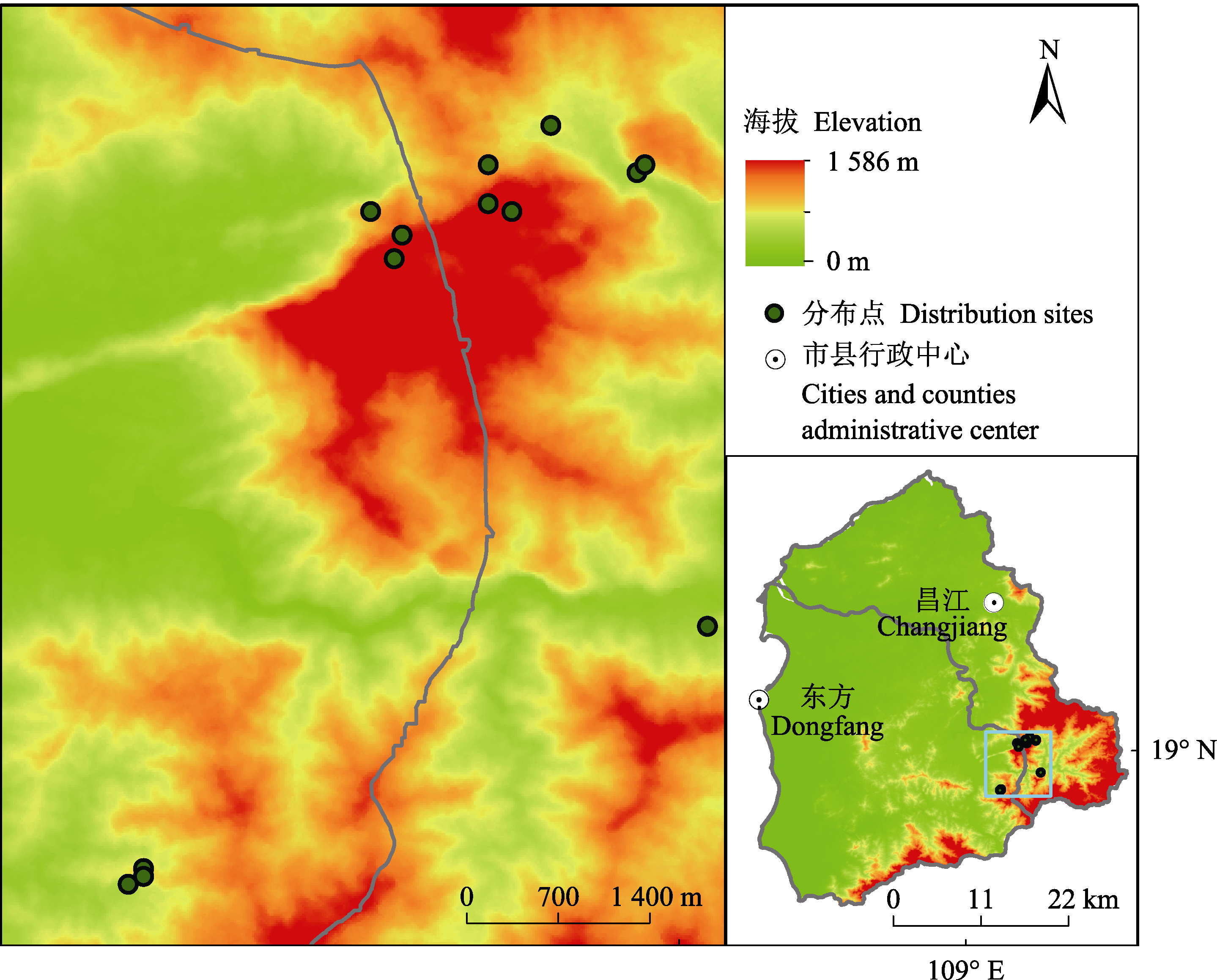
图1 海南凤仙花实际地理分布图。
Fig. 1 Actual geographic distribution maps of Impatiens hainanensis.
| 地点 Sites | 种群编码 Populations code | 经度 Longitude | 纬度 Latitude | 海拔 Altitude (m) |
|---|---|---|---|---|
| 俄贤岭 Exian Moutain | Pop1 | 109.094° E | 19.013° N | 945 |
| Pop 2 | 109.098° E | 19.010° N | 890 | |
| Pop 3 | 109.097° E | 19.007° N | 1 000 | |
| Pop 4 | 109.109° E | 19.104° N | 490 | |
| Pop 5 | 109.112° E | 19.013° N | 1 050 | |
| 王下乡 Wangxia Village | Pop6 | 109.117° E | 19.024° N | 450 |
| Pop7 | 109.109° E | 19.019° N | 590 | |
| Pop8 | 109.128° E | 19.018° N | 350 | |
| Pop9 | 109.129° E | 19.019° N | 460 | |
| 皇帝洞 Huangdidong | Pop10 | 109.137° E | 18.960° N | 250 |
| 猕猴岭保护区 Mihouling Reserve | Pop11 | 109.065° E | 18.929° N | 480 |
| Pop12 | 109.065° E | 18.928° N | 400 | |
| Pop13 | 109.063° E | 18.927° N | 340 |
附录I 野外调查的海南凤仙花13个种群的基本情况
Supplement I Basic information for the 13 Impatiens hainanensis populations investigated in the field
| 地点 Sites | 种群编码 Populations code | 经度 Longitude | 纬度 Latitude | 海拔 Altitude (m) |
|---|---|---|---|---|
| 俄贤岭 Exian Moutain | Pop1 | 109.094° E | 19.013° N | 945 |
| Pop 2 | 109.098° E | 19.010° N | 890 | |
| Pop 3 | 109.097° E | 19.007° N | 1 000 | |
| Pop 4 | 109.109° E | 19.104° N | 490 | |
| Pop 5 | 109.112° E | 19.013° N | 1 050 | |
| 王下乡 Wangxia Village | Pop6 | 109.117° E | 19.024° N | 450 |
| Pop7 | 109.109° E | 19.019° N | 590 | |
| Pop8 | 109.128° E | 19.018° N | 350 | |
| Pop9 | 109.129° E | 19.019° N | 460 | |
| 皇帝洞 Huangdidong | Pop10 | 109.137° E | 18.960° N | 250 |
| 猕猴岭保护区 Mihouling Reserve | Pop11 | 109.065° E | 18.929° N | 480 |
| Pop12 | 109.065° E | 18.928° N | 400 | |
| Pop13 | 109.063° E | 18.927° N | 340 |
| 变量及数据 Variable and data | 代码 Code | 来源 Source | 原始坐标系 Original coordinate system |
|---|---|---|---|
| 昼夜温差月平均值 Mean diurnal range (Mean of monthly (max temperature - min temperature)) | bio2 | 世界气候数据库 Worldclim | WGS84 |
| 等温性 Isothermality | bio3 | ||
| 气温季节性变化标准偏差 Standard deviation of air temperature seasonality | bio4 | ||
| 气温年较差 Air temperature annual range | bio7 | ||
| 最冷季平均气温 Mean air temperature of coldest quarter | bio11 | ||
| 年降水量 Annual precipitation | bio12 | ||
| 降水量季节性变异系数 Coefficient of variation of precipitation seasonality | bio15 | ||
| 最湿季降水量 Precipitation of wettest quarter | bio16 | ||
| 最干季降水量 Precipitation of driest quarter | bio17 | ||
| 海拔 Elevation | ele | 地理空间数据云 Geospatial data cloud (Computer network information center of Chinese academy of sciences) | WGS84 |
| 坡度 Slope | slo | ||
| 坡向 Aspect | asp | ||
| 海南凤仙花分布点 Distribution points of Impatiens hainanensis | - | 实地调查 Field survey | WGS84 |
| 海南岛土地覆被类型图 Land cover type map of Hainan Island | - | 海南省林业厅 Forestry department of Hainan | WGS84 |
表1 生境评价数据信息表
Table 1 Data information of habitat evaluation
| 变量及数据 Variable and data | 代码 Code | 来源 Source | 原始坐标系 Original coordinate system |
|---|---|---|---|
| 昼夜温差月平均值 Mean diurnal range (Mean of monthly (max temperature - min temperature)) | bio2 | 世界气候数据库 Worldclim | WGS84 |
| 等温性 Isothermality | bio3 | ||
| 气温季节性变化标准偏差 Standard deviation of air temperature seasonality | bio4 | ||
| 气温年较差 Air temperature annual range | bio7 | ||
| 最冷季平均气温 Mean air temperature of coldest quarter | bio11 | ||
| 年降水量 Annual precipitation | bio12 | ||
| 降水量季节性变异系数 Coefficient of variation of precipitation seasonality | bio15 | ||
| 最湿季降水量 Precipitation of wettest quarter | bio16 | ||
| 最干季降水量 Precipitation of driest quarter | bio17 | ||
| 海拔 Elevation | ele | 地理空间数据云 Geospatial data cloud (Computer network information center of Chinese academy of sciences) | WGS84 |
| 坡度 Slope | slo | ||
| 坡向 Aspect | asp | ||
| 海南凤仙花分布点 Distribution points of Impatiens hainanensis | - | 实地调查 Field survey | WGS84 |
| 海南岛土地覆被类型图 Land cover type map of Hainan Island | - | 海南省林业厅 Forestry department of Hainan | WGS84 |
| 评估指标 Evaluate index | 失败 Fail | 很差 Very poor | 一般 Common | 较准确 Good | 优秀 Excellent | 本实验结果值(平均值±标准偏差) Result value of this experiment (mean ± SD) |
|---|---|---|---|---|---|---|
| AUC | 0.50-0.60 | 0.60-0.70 | 0.70-0.80 | 0.80-0.90 | 0.90-1.00 | 0.98 ± 0.02 |
| Kappa | 0-0.40 | 0.40-0.55 | 0.55-0.70 | 0.70-0.85 | 0.85-1.00 | 0.96 ± 0.08 |
| TSS | 0-0.40 | 0.40-0.55 | 0.55-0.70 | 0.70-0.85 | 0.85-1.00 | 0.96 ± 0.08 |
| Overall accuracy | 0-0.40 | 0-0.55 | 0.55-0.70 | 0.70-0.85 | 0.85-1.00 | 0.98 ± 0.04 |
表2 4种评估指标(受试者工作特征曲线下面积、卡帕系数、真实技巧统计值、总体精度)的评价标准
Table 2 The criteria of the four evaluate indexes(area under the receiver operating characteristic curve (AUC), kappa coefficient, true skill statistic (TSS), overall accuracy)
| 评估指标 Evaluate index | 失败 Fail | 很差 Very poor | 一般 Common | 较准确 Good | 优秀 Excellent | 本实验结果值(平均值±标准偏差) Result value of this experiment (mean ± SD) |
|---|---|---|---|---|---|---|
| AUC | 0.50-0.60 | 0.60-0.70 | 0.70-0.80 | 0.80-0.90 | 0.90-1.00 | 0.98 ± 0.02 |
| Kappa | 0-0.40 | 0.40-0.55 | 0.55-0.70 | 0.70-0.85 | 0.85-1.00 | 0.96 ± 0.08 |
| TSS | 0-0.40 | 0.40-0.55 | 0.55-0.70 | 0.70-0.85 | 0.85-1.00 | 0.96 ± 0.08 |
| Overall accuracy | 0-0.40 | 0-0.55 | 0.55-0.70 | 0.70-0.85 | 0.85-1.00 | 0.98 ± 0.04 |
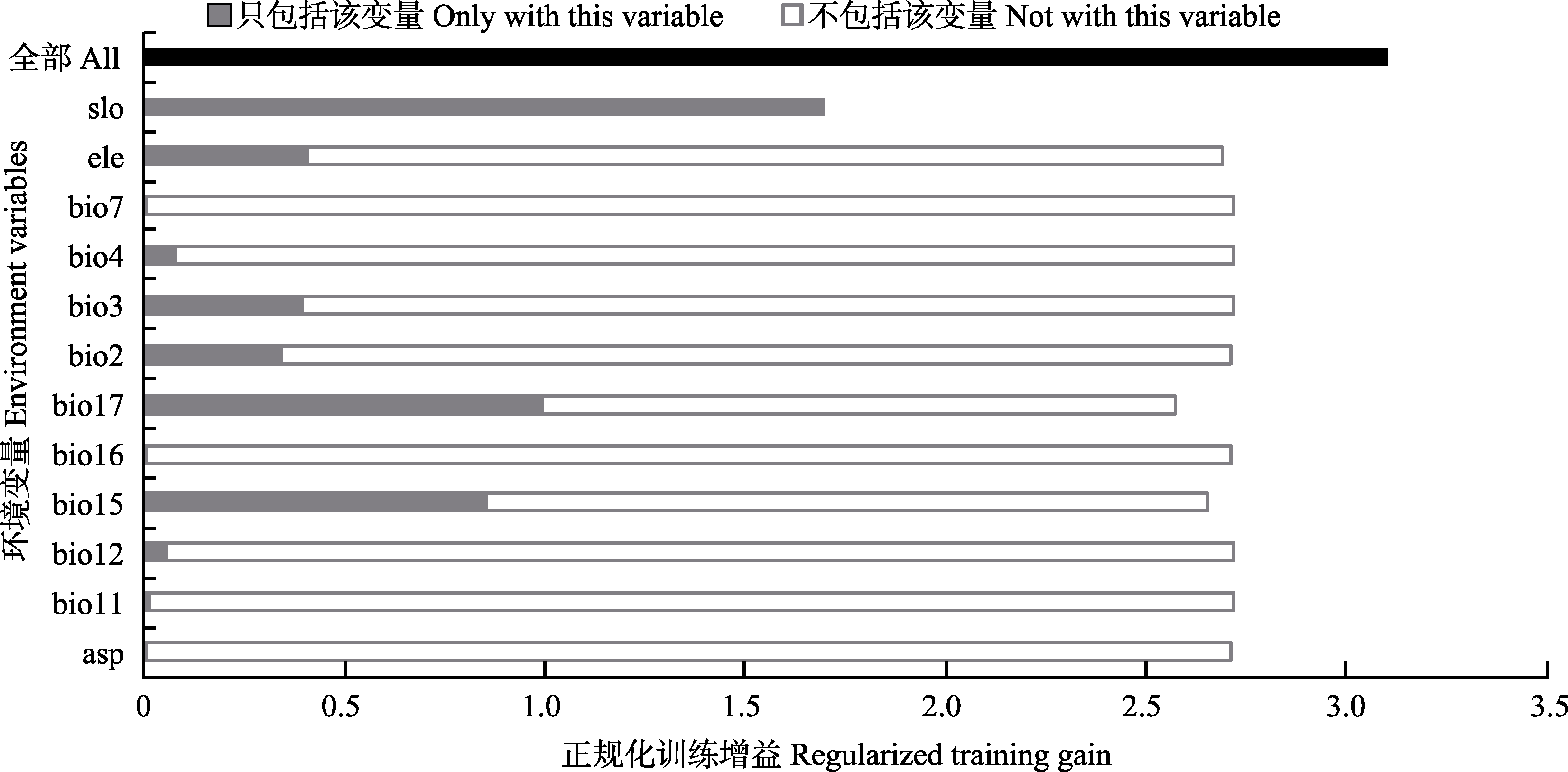
图2 海南凤仙花环境因子刀切法检验结果。代码请参见表1。
Fig. 2 The jackknife test result of environmental factor for Impatiens hainanensis. See Table 1 for the codes.
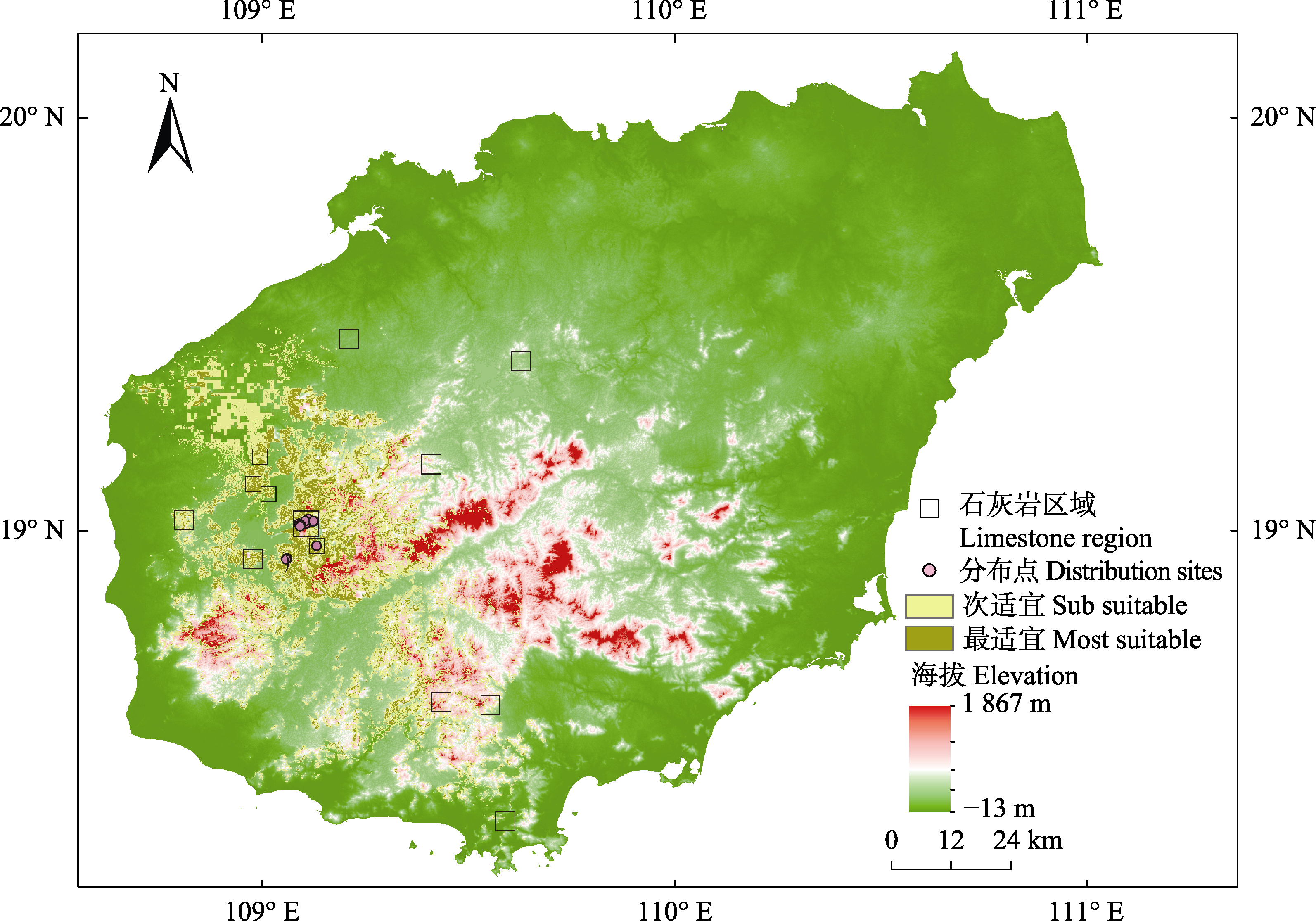
图3 海南凤仙花在海南岛的潜在适宜生境分布。
Fig. 3 The potential distribution of suitable habitat for Impatiens hainanensis in Hainan Island.
| [1] | Aguilar SV, Melgoza CA, Villarreal GF, Wehenkel C, Pinedo AC ( 2015). Modeling the potential distribution of Picea chihuahuana Martínez, an endangered species at the Sierra Madre Occidental, Mexico. Forests, 6, 692-707. |
| [2] |
Beaumont LJ, Hughes L, Poulsen M ( 2005). Predicting species distributions: Use of climatic parameters in BIOCLIM and its impact on predictions of species’ current and future distributions. Ecological Modelling, 186, 250-269.
DOI URL |
| [3] | Bennington CC, Mcgraw JB ( 1996). Environment-dependence of quantitative genetic parameters in Impatiens pallida. Evolution, 50, 1083-1097. |
| [4] |
Chu JM, Li YF, Zhang L, Li B, Gao MY, Tang XQ, Ni JW, Xu XQ ( 2017). Potential distribution range and conservation strategies for the endangered species Amygdalus pedunculata. Biodiversity Science, 25, 799-806.
DOI URL |
|
[ 褚建民, 李毅夫, 张雷, 李斌, 高明远, 唐晓倩, 倪建伟, 许新桥 ( 2017). 濒危物种长柄扁桃的潜在分布与保护策略. 生物多样性, 25, 799-806.]
DOI URL |
|
| [5] | Deb CR, Jamir NS, Kikon ZP ( 2017). Distribution prediction model of a rare orchid species ( Vanda bicolor Griff.) using small sample size. American Journal of Plant Sciences, 8, 1388-1398. |
| [6] |
Deng Y, Jiang ZC, Qin XM ( 2012). Water source partitioning among trees growing on carbonate rock in a subtropical region of Guangxi, China. Environmental Earth Sciences, 66, 635-640.
DOI URL |
| [7] |
Engler R, Guisan A, Rechsteiner L ( 2004). An improved approach for predicting the distribution of rare and endangered species from occurrence and pseudo-absence data. Journal of Applied Ecology, 41, 263-274.
DOI URL |
| [8] |
Fois M, Fenu G, Lombra?a AC, Cogoni D, Bacchetta G ( 2015). A practical method to speed up the discovery of unknown populations using species distribution models. Journal for Nature Conservation, 24, 42-48.
DOI URL |
| [9] |
Francisco-Ortega J, Wang FG, Wang ZS, Xing FW, Liu H, Xu H, Xu WX, Luo YB, Song XQ, Gale S, Boufford DE, Maunder M, An SQ ( 2010). Endemic seed plant species from Hainan Island: A checklist. The Botanical Review, 76, 295-345.
DOI URL |
| [10] | Gao FY ( 2012). A Study on Melica przewalskyi Population Spatial Pattern and Response to Soil Moisture in Degraded Alpine Grassland. Master degree dissertation, Northwest Normal University, Lanzhou. |
| [ 高福元 ( 2012). 高寒退化草地甘肃臭草种群空间分布格局对土壤水分的响应. 硕士学位论文, 西北师范大学, 兰州.] | |
| [11] |
Hernandez PA, Graham CH, Master LL, Albert DL ( 2006). The effect of sample size and species characteristics on performance of different species distribution modeling methods. Ecography, 29, 773-785.
DOI URL |
| [12] |
Hijmans RJ, Cameron SE, Parra JL, Jones PG, Jarvis A ( 2005). Very high resolution interpolated climate surfaces for global land areas. International Journal of Climatology, 25, 1965-1978.
DOI URL |
| [13] |
Hu QP, Guo ZH, Li CY, Ma L ( 2008). Advance at phenotypic plasticity in plant responses to abiotic factors. Scientia Silvae Cinicae, 44, 135-142.
DOI URL |
|
[ 胡启鹏, 郭志华, 李春燕, 马履 ( 2008). 植物表型可塑性对非生物环境因子的响应研究进展. 林业科学, 44, 135-142.]
DOI URL |
|
| [14] | Kumar S, Stohlgren TJ ( 2009). Maxent modeling for predicting suitable habitat for threatened and endangered tree Canacomyrica monticola in New Caledonia. Journal of Ecology & the Natural Environment, 1, 94-98. |
| [15] | Lasky JR, Uriarte M, Muscarella R ( 2016). Synchrony, co-mpensatory dynamics, and the functional trait basis ofphonological diversity in a tropical dry forest tree co-mmunity: Effects of rainfall seasonality. EnvironmentalResearch Letters, 11, 115003. DOI: 10.1088/1748-9326/11/11/115003. |
| [16] |
Leng X, Wang ZS, An SQ, Feng J, Liu YH, Wang GM ( 2005). ISSR analysis of genetic diversity of Ilex integra, an insular endemic plant. Biodiversity Science, 13, 546-554.
DOI URL |
|
[ 冷欣, 王中生, 安树青, 冯珏, 刘玉虹, 王国明 ( 2005). 岛屿特有种全缘冬青遗传多样性的ISSR分析. 生物多样性, 13, 546-554.]
DOI URL |
|
| [17] |
Liu QL, Li Y, Fang SZ ( 2017). Identification of potential cultivation region for Cyclocarya paliurus in China based on MaxEnt model. Journal of Nanjing Forestry University (Natural Science), 41, 25-29.
DOI URL |
|
[ 刘清亮, 李垚, 方升佐 ( 2017). 基于MaxEnt模型的青钱柳潜在适宜栽培区预测. 南京林业大学学报(自然科学版), 41, 25-29.]
DOI URL |
|
| [18] |
Ma SM, Nie YB, Geng QL, Wang RX ( 2014). Impact of climate change on suitable distribution range and spatial pattern in Amygdalus mongolica. Chinese Journal of Plant Ecology, 38, 262-269.
DOI URL |
|
[ 马松梅, 聂迎彬, 耿庆龙, 王荣学 ( 2014). 气候变化对蒙古扁桃适宜分布范围和空间格局的影响. 植物生态学报, 38, 262-269.]
DOI URL |
|
| [19] | Majid A, Ahmad H, Saqib Z, Ali H ( 2015). Potential distribution of endemic Scutellaria chamaedrifolia geographic information system and statistical model approach. Pakistan Journal of Botany, 47, 51-56. |
| [20] |
Merow C, Smith MJ, Silander JA ( 2013). A practical guide to MaxEnt for modeling species’ distributions: What it does, and why inputs and settings matter. Ecography, 36, 1058-1069.
DOI URL |
| [21] |
Nie YP, Chen HS, Wang KL ( 2011). Seasonal variation of water sources for plants growing on continuous rock outcrops in limestone area of Southwest China. Chinese Journal of Plant Ecology, 35, 1029-1037.
DOI URL |
|
[ 聂云鹏, 陈洪松, 王克林 ( 2011). 石灰岩地区连片出露石丛生境植物水分来源的季节性差异. 植物生态学报, 35, 1029-1037.]
DOI URL |
|
| [22] |
Qin XS, He KS, Liu LW, Sun JM, Qi XM, Shi H ( 2012). Floristic and ecological characteristics of the community with Impatiens hainanensis in exianling limestone moutain, Hainan. Journal of South China Agricultural University, 33, 361-367.
DOI URL |
|
[ 秦新生, 何科稣, 刘立武, 孙君梅, 齐旭明, 施浩 ( 2012). 海南俄贤岭石灰岩山地海南凤仙花所在群落植物区系及生态特征. 华南农业大学学报, 33, 361-367.]
DOI URL |
|
| [23] |
Qin XS, Zhang RJ, Chen HF, Wang FG, Tian HZ, Xing FW ( 2005). The resource and conservation on the rare and endangered plants in limestone regions in Hainan Island. Acta Scientiarum Naturalium Universitatis Sunyatseni (Natural Science), 44, 291-298.
DOI URL |
|
[ 秦新生, 张荣京, 陈红锋, 王发国, 田怀珍, 邢福武 ( 2005). 海南岛石灰岩地区珍稀濒危植物及其保护. 中山大学学报(自然科学版), 44, 291-298.]
DOI URL |
|
| [24] |
Qin XS, Zhang RJ, Xing FW ( 2014). Flora of seed plants in the limestone areas of Hainan. Journal of South China Agricultural University, 35, 90-99.
DOI URL |
|
[ 秦新生, 张荣京, 邢福武 ( 2014). 海南石灰岩地区的种子植物区系. 华南农业大学学报, 35, 90-99.]
DOI URL |
|
| [25] |
Rushton SP, Ormerod SJ, Kerby G ( 2004). New paradigms for modelling species distributions? Journal of Applied Ecology, 41, 193-200.
DOI URL |
| [26] | Shi W ( 2013). Effects of Climate Change on Distribution of Larix gmelinii in Northeast China. Master degree dissertation, Beijing Forestry University, Beijing. |
| [ 石慰 ( 2013). 气候变化对中国东北兴安落叶松分布的影响. 硕士学位论文, 北京林业大学, 北京.] | |
| [27] |
Wu J, Qin F, Wang W, Chen P, Gao SH, Xu HJ, Lin Q, Zhu CQ, Yu YC ( 2010). Research progress of soil and peculiar plants in limestone areas of China. Journal of Jiangsu Forestry Science & Technology, 37, 50-54.
DOI URL |
|
[ 吴静, 秦飞, 王维, 陈平, 高世虎, 徐辉筠, 林琴, 朱朝芹, 俞元春 ( 2010). 我国石灰岩地区特有植物研究进展. 江苏林业科技, 37, 50-54.]
DOI URL |
|
| [28] |
Wu JG, Lü JJ, Zhou QF ( 2010). Potential effects of climate change on the distribution of six desert plants in China. Chinese Bulletin of Botany, 45, 723-738.
DOI URL |
|
[ 吴建国, 吕佳佳, 周巧富 ( 2010). 气候变化对6种荒漠植物分布的潜在影响. 植物学通报, 45, 723-738.]
DOI URL |
|
| [29] |
Xu ZL, Peng HH, Peng SZ ( 2015). The development and evaluation of species distribution models. Acta Ecologica Sinica, 35, 557-567.
DOI URL |
|
[ 许仲林, 彭焕华, 彭守璋 ( 2015). 物种分布模型的发展及评价方法. 生态学报, 35, 557-567.]
DOI URL |
|
| [30] |
Ying LX, Liu Y, Chen ST, Shen ZH ( 2016). Simulation of the potential range of Pistacia weinmannifolia in Southwest China with climate change based on the maximum-entropy (Maxent) model. Biodiversity Science, 24, 453-461.
DOI URL |
|
[ 应凌霄, 刘晔, 陈绍田, 沈泽昊 ( 2016). 气候变化情景下基于最大熵模型的中国西南地区清香木潜在分布格局模拟. 生物多样性, 24, 453-461.]
DOI URL |
|
| [31] | Yuan TX, Zhang HP, Ou ZY, Tan YB ( 2014). Effects of topography on the diversity and distribution pattern of ground plants in karst montane forests in Southwest Guangxi, China. Chinese Journal of Applied Ecology, 25, 2803-2810. |
| [ 袁铁象, 张合平, 欧芷阳, 谭一波 ( 2014). 地形对桂西南喀斯特山地森林地表植物多样性及分布格局的影响. 应用生态学报, 25, 2803-2810.] | |
| [32] |
Zhen JH ( 2008). Landscape Dynamics and Suitability Assessment of Endangered Plant Tetraena Mongolica’s Habitats. PhD dissertation, Inner Mongolian Agricultural University, Huhhot.
DOI URL |
|
[ 甄江红 ( 2008). 濒危植物四合木生境的景观动态与适宜性评价研究. 博士学位论文, 内蒙古农业大学, 呼和浩特.]
DOI URL |
|
| [33] | Zhong YF ( 2014). Conservation Ecology of Impatiens hainanensis (Balsaminaceae), Endemic Species in Hainan Island. PhD dissertation, Hainan University, Haikou. |
| [ 钟云芳 ( 2014). 海南凤仙花保育生态学研究. 博士学位论文, 海南大学, 海口.] |
| [1] | 吴茹茹, 刘美珍, 谷仙, 常馨月, 郭立月, 蒋高明, 祁如意. 气候变化对巨柏适宜生境分布的潜在影响和预测[J]. 植物生态学报, 2024, 48(4): 445-458. |
| [2] | 钟姣, 姜超, 刘世荣, 龙文兴, 孙建新. 海南长臂猿食源植物的潜在物种丰富度分布格局[J]. 植物生态学报, 2023, 47(4): 491-505. |
| [3] | 左永令, 杨小波, 李东海, 吴二焕, 杨宁, 李龙, 张培春, 陈琳, 李晨笛. 环境因子对海南岛野生兰科植物物种组成与分布格局的影响[J]. 植物生态学报, 2021, 45(12): 1341-1349. |
| [4] | 刘晓彤, 袁泉, 倪健. 中国植物分布模拟研究现状[J]. 植物生态学报, 2019, 43(4): 273-283. |
| [5] | 陈怡超, 赵莹, 宋希强, 任明迅. 海南杜鹃在河岸带弯道两侧的空间分布格局和年龄结构差异[J]. 植物生态学报, 2018, 42(8): 841-849. |
| [6] | 李艳朋, 许涵, 李意德, 骆土寿, 陈德祥, 周璋, 林明献, 杨怀. 海南尖峰岭热带山地雨林物种多样性空间分布格局的尺度效应[J]. 植物生态学报, 2016, 40(9): 861-870. |
| [7] | 王茜茜, 龙文兴, 杨小波, 熊梦辉, 康勇, 黄瑾, 王旭, 洪小江, 周照骊, 陆雍泉, 方精, 李时兴. 海南岛3个林区热带云雾林植物多样性变化[J]. 植物生态学报, 2016, 40(5): 469-479. |
| [8] | 杨怀, 李意德, 任海, 骆土寿, 陈仁利, 刘文杰, 陈德祥, 许涵, 周璋, 林明献, 杨秋, 姚海荣, 周国逸. 海南岛热带原始森林主要分布区土壤有机碳密度及影响因素[J]. 植物生态学报, 2016, 40(4): 292-303. |
| [9] | 罗文启, 符少怀, 杨小波, 陈玉凯, 周威, 杨琦, 陶楚, 周文嵩. 海南岛入侵植物的分布特点及其对本地植物的影响[J]. 植物生态学报, 2015, 39(5): 486-500. |
| [10] | 黄运峰,路兴慧,臧润国,丁易,龙文兴,王进强,杨民,黄运天. 海南岛热带低地雨林刀耕火种弃耕地自然恢复过程中的群落构建[J]. 植物生态学报, 2013, 37(5): 415-426. |
| [11] | 盛大勇, 庄雪影, 许涵, 李意德, 胡跃华, 时雷雷, 骆土寿, 陈德祥, 林明献. 尖峰岭热带山地雨林海南特有木本植物群落结构[J]. 植物生态学报, 2012, 36(9): 935-947. |
| [12] | 黄运峰,丁易,臧润国,李小成,邹正冲,韩文涛. 海南岛霸王岭热带低地雨林树木的空间格局[J]. 植物生态学报, 2012, 36(4): 269-280. |
| [13] | 丁易, 臧润国. 海南岛霸王岭热带低地雨林植被恢复动态[J]. 植物生态学报, 2011, 35(5): 577-586. |
| [14] | 刘广福, 臧润国, 丁易, 王文毅, 李儒财, 陈少伟, 周照骊. 海南霸王岭不同森林类型附生兰科植物的多样性和分布[J]. 植物生态学报, 2010, 34(4): 396-408. |
| [15] | 马松梅, 张明理, 张宏祥, 孟宏虎, 陈曦. 利用最大熵模型和规则集遗传算法模型预测孑遗植物裸果木的潜在地理分布及格局[J]. 植物生态学报, 2010, 34(11): 1327-1335. |
| 阅读次数 | ||||||
|
全文 |
|
|||||
|
摘要 |
|
|||||
Copyright © 2026 版权所有 《植物生态学报》编辑部
地址: 北京香山南辛村20号, 邮编: 100093
Tel.: 010-62836134, 62836138; Fax: 010-82599431; E-mail: apes@ibcas.ac.cn, cjpe@ibcas.ac.cn
备案号: 京ICP备16067583号-19
![]()