
Chin J Plant Ecol ›› 2022, Vol. 46 ›› Issue (10): 1268-1279.DOI: 10.17521/cjpe.2022.0234
Special Issue: 红树林及红树植物; 全球变化与生态系统; 生态遥感及应用
• Research Articles • Previous Articles Next Articles
JIANG Yu-Feng1,2, LI Jing1,2, XIN Rui-Rui1,2, LI Yi1,2,*( )
)
Received:2022-06-06
Accepted:2022-09-05
Online:2022-10-20
Published:2022-09-28
Contact:
*LI Yi(yili@xmu.edu.cn)
Supported by:JIANG Yu-Feng, LI Jing, XIN Rui-Rui, LI Yi. Spatial-temporal dynamics of coastal aquaculture ponds and its impacts on mangrove ecosystems[J]. Chin J Plant Ecol, 2022, 46(10): 1268-1279.
Add to citation manager EndNote|Ris|BibTeX
URL: https://www.plant-ecology.com/EN/10.17521/cjpe.2022.0234
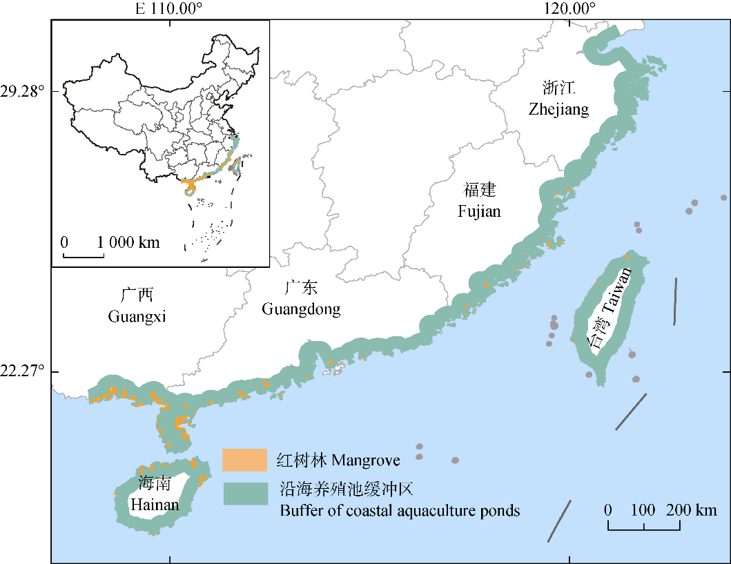
Fig. 1 Distribution of the buffer zone of coastal aquaculture ponds in the provinces with mangroves in China.

Fig. 2 Spatial distribution of inundation frequency.
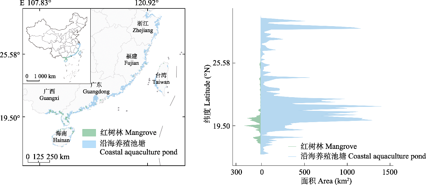
Fig. 3 Spatial distribution and latitudinal distribution of mangroves and coastal aquaculture ponds in 2020.

Fig. 4 Temporal changes in the area of aquaculture ponds in the provinces with mangroves from 1990 to 2020. A, Total area of aquaculture ponds in six provinces with mangroves from 1990 to 2020. B, Increase in the area of aquaculture ponds and the decadal growth rate in 3 periods from 1990 to 2020. C-H, Total area of aquaculture ponds in each province.
| 年份 Year | 类别 Class | 养殖池塘 Aquaculture ponds | 非养殖池塘 Non-aquaculture ponds | 生产者精度 PA (%) | 用户精度 UA (%) | 总精度 OA (%) | Kappa |
|---|---|---|---|---|---|---|---|
| 2020 | 养殖池塘 Aquaculture ponds | 347 | 53 | 98.58 | 86.75 | 89.34 | 0.75 |
| 非养殖池塘 Non-aquaculture ponds | 5 | 139 | 76.37 | 96.53 | |||
| 2010 | 养殖池塘 Aquaculture ponds | 345 | 55 | 98.80 | 86.25 | 88.60 | 0.74 |
| 非养殖池塘 Non-aquaculture ponds | 7 | 137 | 71.35 | 95.14 | |||
| 2000 | 养殖池塘 Aquaculture ponds | 332 | 58 | 98.81 | 83.00 | 86.76 | 0.71 |
| 非养殖池塘 Non-aquaculture ponds | 4 | 140 | 70.71 | 97.22 | |||
| 1990 | 养殖池塘 Aquaculture ponds | 343 | 57 | 99.42 | 85.75 | 89.15 | 0.77 |
| 非养殖池塘 Non-aquaculture ponds | 2 | 142 | 71.00 | 98.61 |
Table 1 Accuracy evaluation of the identification of aquaculture ponds
| 年份 Year | 类别 Class | 养殖池塘 Aquaculture ponds | 非养殖池塘 Non-aquaculture ponds | 生产者精度 PA (%) | 用户精度 UA (%) | 总精度 OA (%) | Kappa |
|---|---|---|---|---|---|---|---|
| 2020 | 养殖池塘 Aquaculture ponds | 347 | 53 | 98.58 | 86.75 | 89.34 | 0.75 |
| 非养殖池塘 Non-aquaculture ponds | 5 | 139 | 76.37 | 96.53 | |||
| 2010 | 养殖池塘 Aquaculture ponds | 345 | 55 | 98.80 | 86.25 | 88.60 | 0.74 |
| 非养殖池塘 Non-aquaculture ponds | 7 | 137 | 71.35 | 95.14 | |||
| 2000 | 养殖池塘 Aquaculture ponds | 332 | 58 | 98.81 | 83.00 | 86.76 | 0.71 |
| 非养殖池塘 Non-aquaculture ponds | 4 | 140 | 70.71 | 97.22 | |||
| 1990 | 养殖池塘 Aquaculture ponds | 343 | 57 | 99.42 | 85.75 | 89.15 | 0.77 |
| 非养殖池塘 Non-aquaculture ponds | 2 | 142 | 71.00 | 98.61 |

Fig. 5 Evolution of the spatial pattern of mangroves around coastal aquaculture ponds, from 1990 to 2020. Positive values represent an increase in the indicators in each decade, while negative values mean the opposite. AI, aggregation index; AREA_MEAN, mean patch area; ENN_MN, mean euclidean nearest neighbor index; PD, patch density.

Fig. 6 Comparisons of coastal aquaculture ponds in three different places (b, c and d). The distributions of aquaculture ponds on the left side in B-D of the diagram group are the dataset acquired from Ren et al. (2015), and those on the right side are the data products from this study.
| [1] | Baig MHA, Zhang LF, Wang SD, Jiang GZ, Lu SL, Tong QX. (2013). Comparison of MNDWI and DFI for water mapping in flooding season//2013 IEEE International Geoscience and Remote Sensing Symposium-IGARSS. IEEE, Melbourne, Australia. 2876-2879. |
| [2] | Barbier EB, Hacker SD, Kennedy C, Koch EW, Stier AC, Silliman BR. (2011). The value of estuarine and coastal ecosystem services. Ecological Monographs, 8, 169-193. |
| [3] |
Bunting P, Rosenqvist A, Lucas RM, Rebelo LM, Hilarides L, Thomas N, Hardy A, Itoh T, Shimada M, Finlayson CM. (2018). The global mangrove watch—A new 2010 global baseline of mangrove extent. Remote Sensing, 10, 1669. DOI: 10.3390/rs10101669.
DOI |
| [4] |
Cao L, Wang WM, Yang Y, Yang CT, Yuan ZH, Xiong SB, Diana J. (2007). Environmental impact of aquaculture and countermeasures to aquaculture pollution in China. Environmental Science and Pollution Research International, 14, 452-462.
DOI URL |
| [5] | de Groot R, Stuip M, Finlayson M, Davidson N. (2006). Valuing wetlands: guidance for valuing the benefits derived from wetland ecosystem services. Ramsar Technical Report No. 3. Ramsar Convention Secretariat, Gland, Switzerland. |
| [6] |
Donato DC, Kauffman JB, Murdiyarso D, Kurnianto S, Stidham M, Kanninen M. (2011). Mangroves among the most carbon-rich forests in the tropics. Nature Geoscience, 4, 293-297.
DOI URL |
| [7] |
Duan YQ, Li X, Zhang LP, Chen D, Liu S, Ji HY. (2020). Mapping national-scale aquaculture ponds based on the Google Earth Engine in the Chinese coastal zone. Aquaculture, 520, 734666. DOI: 10.1016/j.aquaculture.2019.734666.
DOI |
| [8] | Dwivedi RS, Kandrika S. (2005). Delineation and monitoring of aquaculture areas using multi-temporal space-borne multispectral data. Current Science, 89, 1414-1421. |
| [9] |
Feyisa GL, Meilby H, Fensholt R, Proud SR. (2014). Automated Water Extraction Index: a new technique for surface water mapping using Landsat imagery. Remote Sensing of Environment, 140, 23-35.
DOI URL |
| [10] |
Friess DA, Rogers K, Lovelock CE, Krauss KW, Hamilton SE, Lee SY, Lucas R, Primavera J, Rajkaran A, Shi SH. (2019). The state of the world’s mangrove forests: past, present, and future. Annual Review of Environment and Resources, 44, 89-115.
DOI URL |
| [11] |
Giri C, Ochieng E, Tieszen LL, Zhu Z, Singh A, Loveland T, Masek J, Duke N. (2011). Status and distribution of mangrove forests of the world using earth observation satellite data. Global Ecology and Biogeography, 20, 154-159.
DOI URL |
| [12] |
Goldberg L, Lagomasino D, Thomas N, Fatoyinbo T. (2020). Global declines in human-driven mangrove loss. Global Change Biology, 26, 5844-5855.
DOI URL |
| [13] |
Gonçalves G, Andriolo U, Gonçalves L, Sobral P, Bessa F. (2020). Quantifying marine macro litter abundance on a sandy beach using unmanned aerial systems and object- oriented machine learning methods. Remote Sensing, 12, 2599. DOI: 10.3390/rs12162599.
DOI |
| [14] | Jia MM, Wang ZM, Mao DH, Huang CL, Lu CY. (2021). Spatial-temporal changes of China’s mangrove forests over the past 50 years: an analysis towards the Sustainable Development Goals (SDGs). Chinese Science Bulletin, 66, 3886-3901. |
| [贾明明, 王宗明, 毛德华, 黄春林, 路春燕 (2021). 面向可持续发展目标的中国红树林近50年变化分析. 科学通报, 66, 3886-3901.] | |
| [15] |
McFeeters SK. (1996). The use of the Normalized Difference Water Index (NDWI) in the delineation of open water features. International Journal of Remote Sensing, 17, 1425-1432.
DOI URL |
| [16] |
Naylor RL, Hardy RW, Buschmann AH, Bush SR, Cao L, Klinger DH, Little DC, Lubchenco J, Shumway SE, Troell M. (2021). A 20-year retrospective review of global aquaculture. Nature, 591, 551-563.
DOI URL |
| [17] |
Ottinger M, Clauss K, Kuenzer C. (2017). Large-scale assessment of coastal aquaculture ponds with Sentinel-1 time series data. Remote Sensing, 9, 440. DOI: 10.3390/rs9050440.
DOI |
| [18] | Pattanaik C, Narendra Prasad S. (2011). Assessment of aquaculture impact on mangroves of Mahanadi delta (Orissa), east coast of India using remote sensing and GIS. Ocean & Coastal Management, 54, 789-795. |
| [19] |
Peng YS, Li XL, Wu KL, Peng YG, Chen GZ. (2009). Effect of an integrated mangrove-aquaculture system on aquacultural health. Frontiers of Biology in China, 4, 579-584.
DOI URL |
| [20] |
Prasad KA, Ottinger M, Wei C, Leinenkugel P. (2019). Assessment of coastal aquaculture for India from Sentinel-1 SAR Time Series. Remote Sensing, 11, 357. DOI: 10.3390/rs11030357.
DOI |
| [21] |
Rahman AF, Dragoni D, Didan K, Barreto-Munoz A, Hutabarat JA. (2013). Detecting large scale conversion of mangroves to aquaculture with change point and mixed-pixel analyses of high-fidelity MODIS data. Remote Sensing of Environment, 130, 96-107.
DOI URL |
| [22] |
Ren CY, Wang ZM, Zhang YZ, Zhang B, Chen L, Xi YB, Xiao XM, Doughty RB, Liu MY, Jia MM, Mao DH, Song K. (2019). Rapid expansion of coastal aquaculture ponds in China from Landsat observations during 1984-2016. International Journal of Applied Earth Observation and Geoinformation, 82, 101902. DOI: 10.1016/j.jag.2019.101902.
DOI |
| [23] |
Singh KV, Setia R, Sahoo S, Prasad A, Pateriya B. (2015). Evaluation of NDWI and MNDWI for assessment of waterlogging by integrating digital elevation model and groundwater level. Geocarto International, 30, 650-661.
DOI URL |
| [24] |
Sun Z, Luo JH, Yang JZ, Yu QY, Zhang L, Xue K, Lu LR. (2020). Nation-scale mapping of coastal aquaculture ponds with Sentinel-1 SAR data using Google Earth Engine. Remote Sensing, 12, 3086. DOI: 10.3390/rs12183086.
DOI |
| [25] | Wang WQ, Zhang L, Zhang YM, Wang M. (2021). Research progress of mangrove restoration in abandoned ponds. Journal of Xiamen University (Natural Science), 60, 348-354. |
| [王文卿, 张林, 张雅棉, 王瑁 (2021). 红树林退塘还林研究进展. 厦门大学学报(自然科学版), 60, 348-354.] | |
| [26] | Xu HQ. (2005). A study on information extraction of water body with the Modified Normalized Difference Water Index (MNDWI). Journal of Remote Sensing, 9, 589-595. |
| [徐涵秋 (2005). 利用改进的归一化差异水体指数(MNDWI)提取水体信息的研究. 遥感学报, 9, 589-595.] | |
| [27] | Zanaga D, van DK R, Souverijns N, Brockmann C, Quast R, Wevers J, Grosu A, Arino O. (2021). ESA WorldCover 10 m 2020 v100. [2022-05-26]. https://worldcover2020.esa.int/download. |
| [28] |
Zhang Z, Xu N, Li YF, Li Y. (2022). Sub-continental-scale mapping of tidal wetland composition for East Asia: a novel algorithm integrating satellite tide-level and phenological features. Remote Sensing of Environment, 269, 112799. DOI: 10.1016/j.rse.2021.112799.
DOI |
| [29] |
Zou ZH, Dong JW, Menarguez MA, Xiao XM, Qin YW, Doughty RB, Hooker KV, David Hambright K. (2017). Continued decrease of open surface water body area in Oklahoma during 1984-2015. Science of the Total Environment, 595, 451-460.
DOI URL |
| [1] | WANG Xiu-Ying, CHEN Qi, DU Hua-Li, ZHANG Rui, MA Hong-Lu. Evapotranspiration interpolation in alpine marshes wetland on the Qingzang Plateau based on machine learning [J]. Chin J Plant Ecol, 2023, 47(7): 912-921. |
| [2] | HE Jie, HE Liang, LÜ Du, CHENG Zhuo, XUE Fan, LIU Bao-Yuan, ZHANG Xiao-Ping. Spatiotemporal variation and its driving mechanism of photosynthetic vegetation in the Loess Plateau from 2001 to 2020 [J]. Chin J Plant Ecol, 2023, 47(3): 306-318. |
| [3] | WEN Ke, YAO Huan-Mei, GONG Zhu-Qing, NA Ze-Lin, WEI Yi-Ming, HUANG Yi, CHEN Hua-Quan, LIAO Peng-Ren, TANG Li-Ping. Influence of inundation frequency change on enhanced vegetation index of wetland vegetation in Poyang Lake, China [J]. Chin J Plant Ecol, 2022, 46(2): 148-161. |
| [4] | ZHANG Wen-Qiang, LUO Ge-Ping, ZHENG Hong-Wei, WANG Hao, HAMDI Rafiq, HE Hui-Li, CAI Peng, CHEN Chun-Bo. Analysis of vegetation index changes and driving forces in inland arid areas based on random forest model: a case study of the middle part of northern slope of the north Tianshan Mountains [J]. Chin J Plant Ecol, 2020, 44(11): 1113-1126. |
| Viewed | ||||||
|
Full text |
|
|||||
|
Abstract |
|
|||||
Copyright © 2026 Chinese Journal of Plant Ecology
Tel: 010-62836134, 62836138, E-mail: apes@ibcas.ac.cn, cjpe@ibcas.ac.cn
![]()