植物生态学报 ›› 2005, Vol. 29 ›› Issue (5): 775-780.DOI: 10.17521/cjpe.2005.0102

• 论文 • 上一篇    下一篇

浑善达克沙地榆树疏林自然保护区核心区设计的初步研究

彭羽1,2, 蒋高明1,*(), 李永庚1, 刘美珍1, 牛书丽1, 于顺利1, 杨道斌3   

  1. 1 中国科学院植物研究所植被数量生态学重点实验室,北京 100093
    2 中国科学院研究生院, 北京 100039
    3 北京大学人口研究所, 北京 100871
  • 收稿日期:2004-11-08 接受日期:2005-05-12 出版日期:2005-11-08 发布日期:2005-08-30
  • 通讯作者: 蒋高明
  • 基金资助:
    联合国教科文组织人与生物圈计划干旱区有限资源可持续管理

DETERMINATION OF THE PRIMARY CORE ZONE OF THE PLANNED HUNSHANDAK NATURE RESERVE

PENG Yu1,2, JIANG Gao-Ming1,*(), LI Yong-Geng1, LIU Mei-Zhen1, NIU Shu-Li1, YU Shun-Li1, YANG Dao-Bin3   

  1. 1 Laboratory of Quantitative Vegetation Ecology, Institute of Botany, Chinese Academy of Sciences, Beijng 100093, China
    2 Graduate School of Chinese Academy of Sciences, Beijing 100039, China
    3 Institute of Population, Peking University, Beijing 100871, China
  • Received:2004-11-08 Accepted:2005-05-12 Online:2005-11-08 Published:2005-08-30
  • Contact: JIANG Gao-Ming
  • About author:* E-mail: jgm@ht.rol.cn.net

摘要:

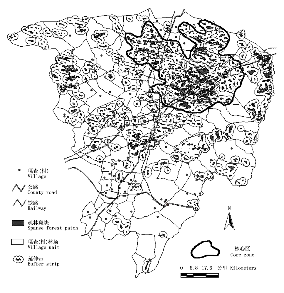
为了保护浑善达克沙地榆树(Ulmus pumila)疏林景观,拟建立自然保护区。基于榆树疏林植被图,运用ArcGIS分析榆树疏林斑块数量、面积、破碎化程度,发现该区榆树疏林斑块大小差异较大,小斑块较多,斑块边界割裂严重,破碎化程度高,需要及时加以保护。按照景观生态学原理、生物岛屿地理学设计自然保护区原则,选择疏林斑块集中分布区,作为潜在核心区,运用ArcGIS的缓冲区分析功能,设计不同的宽度,发现斑块边界向外延伸3 km能够连接较多的斑块,而占用较少的非疏林斑块土地面积。同时调查斑块外不同距离样方与疏林斑块的群落相似度,发现1 km以内能够包含大于10%相似度的群落。由此而初步确定的核心区分布在正蓝旗23个嘎查,面积1 531 km2,约占全旗总面积的13%。

关键词: 自然保护区, 核心区, 规划设计, 浑善达克沙地疏林, 景观破碎化

Abstract:

There are many patches of Ulmus pumila forests distributed in the Hunshandak Sandland, most of them located in the Zhenglan Banner, Inner Mongolia, China. These forest patches are important for combating desertification and sandstorm, conserving biological diversity and landscape views. In order to protect Ulmus pumila forests, the establishment of a nature reserve has been planned for the Hunshandak Sandland. The core zone of the planned nature reserve was determined based on principles of island biogeography theory and landscape ecology theory. First, a map of the distribution region of Ulmus pumila forest patches, a map of communication, and a map of the administrative system of Zhenglan Banner were transferred into a computer. Using ArcGIS software, the patch size, patch distribution, patch density, patch distance, patch segmentation and fragmentation were analyzed. We found that the sparse forest patches were mainly distributed in 20 village regions, and each patch was an average of 0.96 km2. For these 20 villages, the patch density ranged from 0.10 to 0.24 km-2, the edge density ranged from 2.50 to 12.50 km-1, and separating degree ranged from 0.4 to 1.20 km. These indices showed that fragmentation is a serious problem and these forests need to be protected. In order to select the proper sites to make up the core zone, ArcGIS buffer analysis was used to determine the minimum distance necessary to unite the patches into one zone. Most patches could be united using a distance of 3 km. By examining changes in the plant community, a 1 km buffer region around each patch had the greatest value for protection. Thus, a 10 km buffer around the patches could guarantee that most objects would be protected and occupy the least amount of area. According to guidelines for nature reserve planning based on principles of island biogeography, the rest of the zones within the buffer lines need to be included into the core zone. Therefore, the planned core zone will be 1 531 km2 and occupy 13% of total Zhenglan Banner nature reserve. We also discuss how to determine the shape of the core zone with respect to edge effects.

Key words: Nature reserve, Core zone, Design, Hunshandak sandland, Landscape fragmentation