
植物生态学报 ›› 2025, Vol. 49 ›› Issue (3): 404-414.DOI: 10.17521/cjpe.2024.0236 cstr: 32100.14.cjpe.2024.0236
李博文1, 周阳1, 吕静雅1,4, 阿旺2, 陈兰英2, 刘世章2, 伍晶2, 吕汪汪1, 孙建平1, 贾跃凤3, 赵矿5, 汪诗平1,*( )(
)( )
)
收稿日期:2024-07-26
接受日期:2024-12-10
出版日期:2025-03-20
发布日期:2025-01-02
通讯作者:
* 汪诗平(wangsp@itpcas.ac.cn)基金资助:
LI Bo-Wen1, ZHOU Yang1, LÜ Jing-Ya1,4, A Wang2, CHEN Lan-Ying2, LIU Shi-Zhang2, WU Jing2, LÜ Wang-Wang1, SUN Jian-Ping1, JIA Yue-Feng3, ZHAO Kuang5, WANG Shi-Ping1,*()()
Received:2024-07-26
Accepted:2024-12-10
Online:2025-03-20
Published:2025-01-02
Contact:
* WANG Shi-Ping(wangsp@itpcas.ac.cn)Supported by:摘要:
山体物种丰富度及其海拔格局研究是生态学研究的重点内容。以往研究较多关注某个独立山体的物种丰富度, 而对区域尺度内物种丰富度海拔格局的研究多是基于公路沿线或山脚监测的结果, 忽略了山体垂直带物种丰富度的变化。该研究在珠穆朗玛峰绒布河流域选取河流两岸基带海拔分布范围为3 785-5 155 m的8个山体, 结合样线法和样方法调查了8个山体垂直带的物种丰富度。研究表明: (1)共记录了81种植物物种, 其中垂穗披碱草(Elymus nutans)、西藏早熟禾(Poa tibetica)、藓状雪灵芝(Arenaria bryophylla)和笔直黄耆(Astragalus strictus)等在整个流域的8个山体上均有记录; (2)流域尺度上, 单位面积(1 m2)物种丰富度随海拔的变化呈单峰曲线分布。而在各独立山体上, 单位面积物种丰富度沿海拔梯度的分布模式不尽相同, 既有U形分布、正相关, 也有无显著关系的模式; (3)整体上, 山体下部区域的累计物种丰富度要低于山体中上部的累计物种丰富度, 山体阴坡的单位面积物种丰富度要高于山体阳坡。该研究揭示了山体山脚基带的物种丰富度和整个山体的物种丰富度相差很大, 仅在公路沿线或山脚基带处的植物调查会低估整个山体13.5%-54.8%的物种丰富度。因此, 需要开展更多青藏高原山地生态系统物种丰富度在山体空间尺度上分布格局及其关键影响因素和机制的研究。
李博文, 周阳, 吕静雅, 阿旺, 陈兰英, 刘世章, 伍晶, 吕汪汪, 孙建平, 贾跃凤, 赵矿, 汪诗平. 山脚基带调查低估了青藏高原山地物种丰富度: 以珠峰绒布河流域山体垂直带为例. 植物生态学报, 2025, 49(3): 404-414. DOI: 10.17521/cjpe.2024.0236
LI Bo-Wen, ZHOU Yang, LÜ Jing-Ya, A Wang, CHEN Lan-Ying, LIU Shi-Zhang, WU Jing, LÜ Wang-Wang, SUN Jian-Ping, JIA Yue-Feng, ZHAO Kuang, WANG Shi-Ping. Underestimation of mountain species richness on the Qingzang Plateau when using base zone surveys: a case study of mountain vertical vegetation spectrum in the Rongbu River watershed of Mount Qomolangma. Chinese Journal of Plant Ecology, 2025, 49(3): 404-414. DOI: 10.17521/cjpe.2024.0236
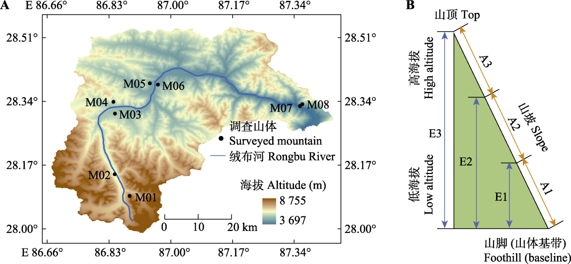
图1 绒布河流域和调查山体的分布(A)及山体调查区域划分示意图(B)。M01-M08分别表示绒布河流域从上游到下游所调查的8个山体坡面; A1、A2、A3分别表示将山体根据海拔高度划分的3个海拔段; E1、E2、E3分别表示每个山体所划分的3种调查情景。
Fig. 1 Distribution of the Rongbu River watershed and surveyed mountains (A) and schematic diagram of the surveyed mountain regions (B). M01-M08 represent eight mountain slopes investigated in the Rongbu River watershed, numbered sequentially from upstream to downstream. A1, A2 and A3 represent three altitude zones classified based on altitude. E1, E2 and E3 represent three survey scenarios defined for each mountain slope.
| 山体编号 Mountain No. | 山体基带海拔 Mountain base altitude (m) | 调查海拔上限 Upper altitude (m) | 样线长度 Transect length (m) | 垂直落差 Altitude difference (m) | 年降水量 Annual Precipitation (mm) | 年平均气温 Mean annual air temperature (℃) | 坡向 Slope | 坐标 Coordinate |
|---|---|---|---|---|---|---|---|---|
| M01 | 5 155 | 5 274 | 700 | 119 | 1 101 | -6.4 | 西南 Southwest | 86.89° E, 28.08° N |
| M02 | 5 150 | 5 281 | 300 | 131 | 685 | -6.2 | 东北 Northeast | 86.85° E, 28.13° N |
| M03 | 4 619 | 5 041 | 1 000 | 422 | 403 | 0.9 | 西北 Northwest | 86.85° E, 28.30° N |
| M04 | 4 695 | 5 029 | 400 | 334 | 451 | 1.7 | 西南 Southwest | 86.85° E, 28.33° N |
| M05 | 4 327 | 4 755 | 600 | 428 | 330 | 3.1 | 东北 Northeast | 86.94° E, 28.37° N |
| M06 | 4 365 | 4 652 | 500 | 287 | 342 | 3.5 | 西南 Southwest | 86.97° E, 28.37° N |
| M07 | 3 785 | 4 123 | 600 | 338 | 734 | 2.2 | 东北 Northeast | 87.35° E, 28.32° N |
| M08 | 3 810 | 4 313 | 500 | 503 | 734 | 2.2 | 西南 Southwest | 87.36° E, 28.31° N |
表1 绒布河流域不同海拔梯度山体详细信息
Table 1 Detailed information in all mountains surveyed in the Rongbu River watershed
| 山体编号 Mountain No. | 山体基带海拔 Mountain base altitude (m) | 调查海拔上限 Upper altitude (m) | 样线长度 Transect length (m) | 垂直落差 Altitude difference (m) | 年降水量 Annual Precipitation (mm) | 年平均气温 Mean annual air temperature (℃) | 坡向 Slope | 坐标 Coordinate |
|---|---|---|---|---|---|---|---|---|
| M01 | 5 155 | 5 274 | 700 | 119 | 1 101 | -6.4 | 西南 Southwest | 86.89° E, 28.08° N |
| M02 | 5 150 | 5 281 | 300 | 131 | 685 | -6.2 | 东北 Northeast | 86.85° E, 28.13° N |
| M03 | 4 619 | 5 041 | 1 000 | 422 | 403 | 0.9 | 西北 Northwest | 86.85° E, 28.30° N |
| M04 | 4 695 | 5 029 | 400 | 334 | 451 | 1.7 | 西南 Southwest | 86.85° E, 28.33° N |
| M05 | 4 327 | 4 755 | 600 | 428 | 330 | 3.1 | 东北 Northeast | 86.94° E, 28.37° N |
| M06 | 4 365 | 4 652 | 500 | 287 | 342 | 3.5 | 西南 Southwest | 86.97° E, 28.37° N |
| M07 | 3 785 | 4 123 | 600 | 338 | 734 | 2.2 | 东北 Northeast | 87.35° E, 28.32° N |
| M08 | 3 810 | 4 313 | 500 | 503 | 734 | 2.2 | 西南 Southwest | 87.36° E, 28.31° N |
| 山体编号 Mountain ID | 海拔区间 Altitude range | 物种丰富度 Species richness | 海拔下限 Lower limit of altitude (m) | 海拔上限 Upper limit of altitude (m) |
|---|---|---|---|---|
| M01 | A1 | 32 | 5 155 | 5 195 |
| A2 | 13 | 5 195 | 5 235 | |
| A3 | 15 | 5 235 | 5 275 | |
| M02 | A1 | 16 | 5 150 | 5 194 |
| A2 | 19 | 5 194 | 5 238 | |
| A3 | 24 | 5 238 | 5 281 | |
| M03 | A1 | 30 | 4 619 | 4 760 |
| A2 | 31 | 4 760 | 4 901 | |
| A3 | 36 | 4 901 | 5 041 | |
| M04 | A1 | 19 | 4 695 | 4 807 |
| A2 | 24 | 4 807 | 4 918 | |
| A3 | 24 | 4 918 | 5 029 | |
| M05 | A1 | 24 | 4 327 | 4 470 |
| A2 | 29 | 4 470 | 4 613 | |
| A3 | 33 | 4 613 | 4 755 | |
| M06 | A1 | 20 | 4 365 | 4 461 |
| A2 | 35 | 4 461 | 4 567 | |
| A3 | 28 | 4 567 | 4 652 | |
| M07 | A1 | 14 | 3 785 | 3 898 |
| A2 | 20 | 3 898 | 4 011 | |
| A3 | 23 | 4 011 | 4 123 | |
| M08 | A1 | 10 | 3 810 | 3 978 |
| A2 | 13 | 3 978 | 4 146 | |
| A3 | 11 | 4 146 | 4 313 |
表2 绒布河流域不同山体划分不同海拔段信息表
Table 2 Information on different mountains categorized by altitude ranges in the Rongbu River watershed
| 山体编号 Mountain ID | 海拔区间 Altitude range | 物种丰富度 Species richness | 海拔下限 Lower limit of altitude (m) | 海拔上限 Upper limit of altitude (m) |
|---|---|---|---|---|
| M01 | A1 | 32 | 5 155 | 5 195 |
| A2 | 13 | 5 195 | 5 235 | |
| A3 | 15 | 5 235 | 5 275 | |
| M02 | A1 | 16 | 5 150 | 5 194 |
| A2 | 19 | 5 194 | 5 238 | |
| A3 | 24 | 5 238 | 5 281 | |
| M03 | A1 | 30 | 4 619 | 4 760 |
| A2 | 31 | 4 760 | 4 901 | |
| A3 | 36 | 4 901 | 5 041 | |
| M04 | A1 | 19 | 4 695 | 4 807 |
| A2 | 24 | 4 807 | 4 918 | |
| A3 | 24 | 4 918 | 5 029 | |
| M05 | A1 | 24 | 4 327 | 4 470 |
| A2 | 29 | 4 470 | 4 613 | |
| A3 | 33 | 4 613 | 4 755 | |
| M06 | A1 | 20 | 4 365 | 4 461 |
| A2 | 35 | 4 461 | 4 567 | |
| A3 | 28 | 4 567 | 4 652 | |
| M07 | A1 | 14 | 3 785 | 3 898 |
| A2 | 20 | 3 898 | 4 011 | |
| A3 | 23 | 4 011 | 4 123 | |
| M08 | A1 | 10 | 3 810 | 3 978 |
| A2 | 13 | 3 978 | 4 146 | |
| A3 | 11 | 4 146 | 4 313 |
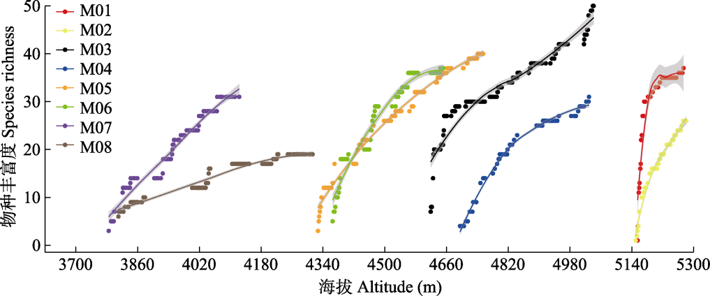
图2 绒布河流域各个山体累计物种丰富度沿海拔高度的变化。M01-M08表示绒布河上游到下游所调查的8个独立山体, 详细信息见表2。
Fig. 2 Variation in cumulative species richness of each mountain along the altitude gradient in the Rongbu River watershed. M01-M08 denote eight independent mountains surveyed from upstream to downstream of the Rongbu River, details see Table 2.
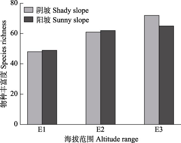
图3 绒布河流域不同山体范围调查情景下累计物种丰富度的变化。E1表示仅调查山体下部, E2表示调查山体中部和下部, E3表示调查整个山体。
Fig. 3 Variation in cumulative species richness with mountain survey altitude range at the watershed scale of Rongbu River (aggregate results of eight mountains). E1 represents surveys limited to the lower part of the mountain, E2 represents surveys in both the middle and lower parts of the mountain, and E3 represents surveys covering the entire mountain.
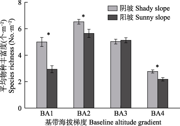
图4 绒布河流域不同基带海拔梯度阴坡和阳坡单位面积物种丰富度的比较。BA1-BA4分别表示从绒布河上游至绒布河下游4个不同的基带海拔高度(分别为5 153、4 657、4 346和3 798 m)。*表示阴坡和阳坡单位面积物种丰富度差异显著(p < 0.05)。
Fig. 4 Comparison of species richness per unit area on shady and sunny slopes across different base zone altitude gradients in Rongbu River watershed. BA1-BA4 represent four different base zone altitude gradients from the upstream to the downstream of the Rongbu River (5 153, 4 657, 4 346 and 3 798 m, respectively). * indicates a significant difference in species richness per unit area between the shady and sunny slopes (p < 0.05).
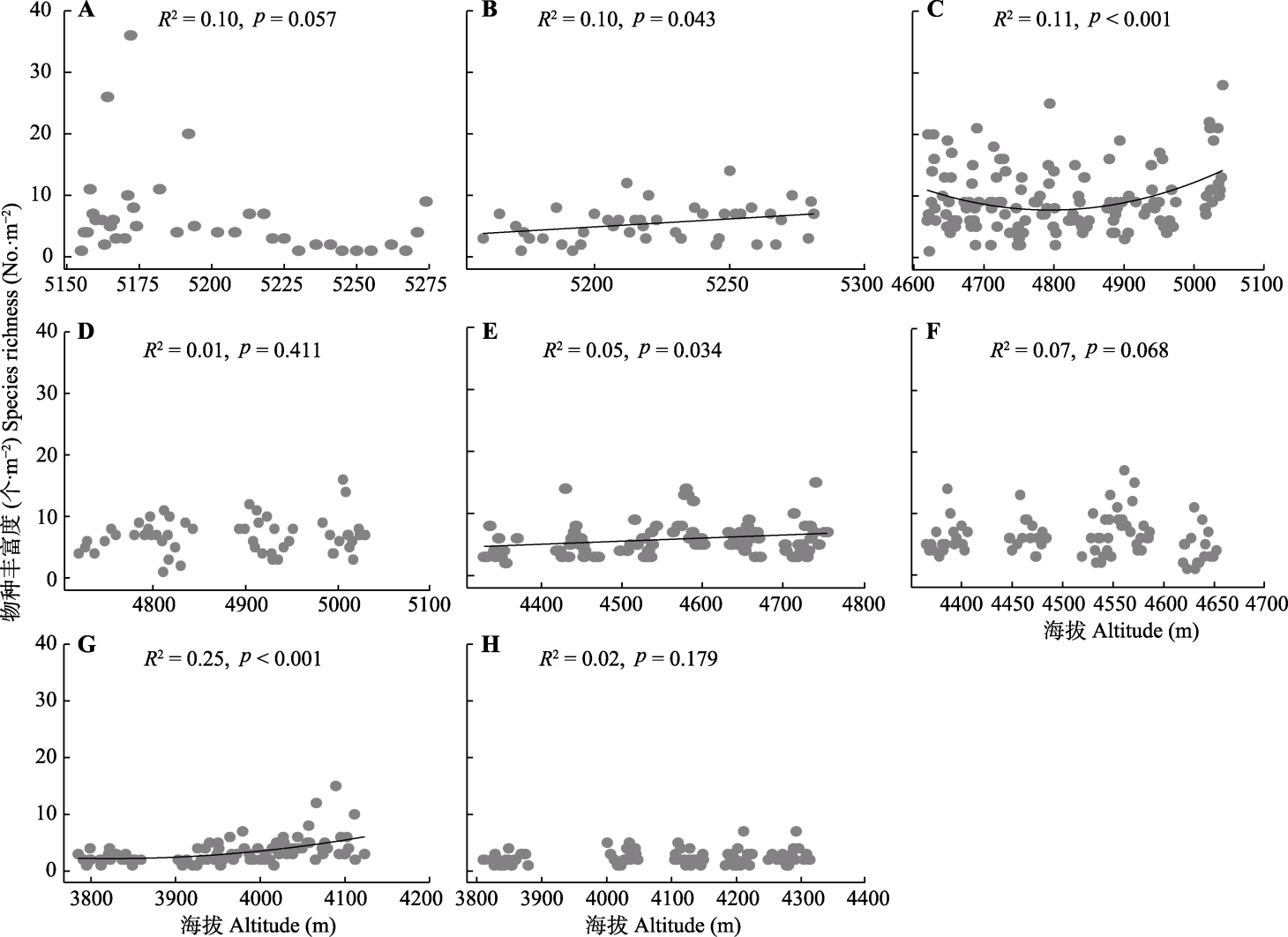
图5 绒布河流域各个山体垂直带物种丰富度和海拔的关系。A-H分别为山体M01-M08的结果, 山体详细信息见表2。灰色的点表示所调查的每个样方物种丰富度。拟合结果的R2和p值标注在了每个子图的上方。如果拟合曲线的p < 0.05, 则用黑色实线绘制拟合曲线。
Fig. 5 Relationship between species richness across altitude gradients on individual mountains in Rongbu River watershed. A-H represent Mountains M01-M08, mountain details see Table 2. Grey points indicate species richness surveyed in each plot. R2 and p values of the fits are annotated in the top of each subplot. Solid black line represents a significant fitted curve (p < 0.05).
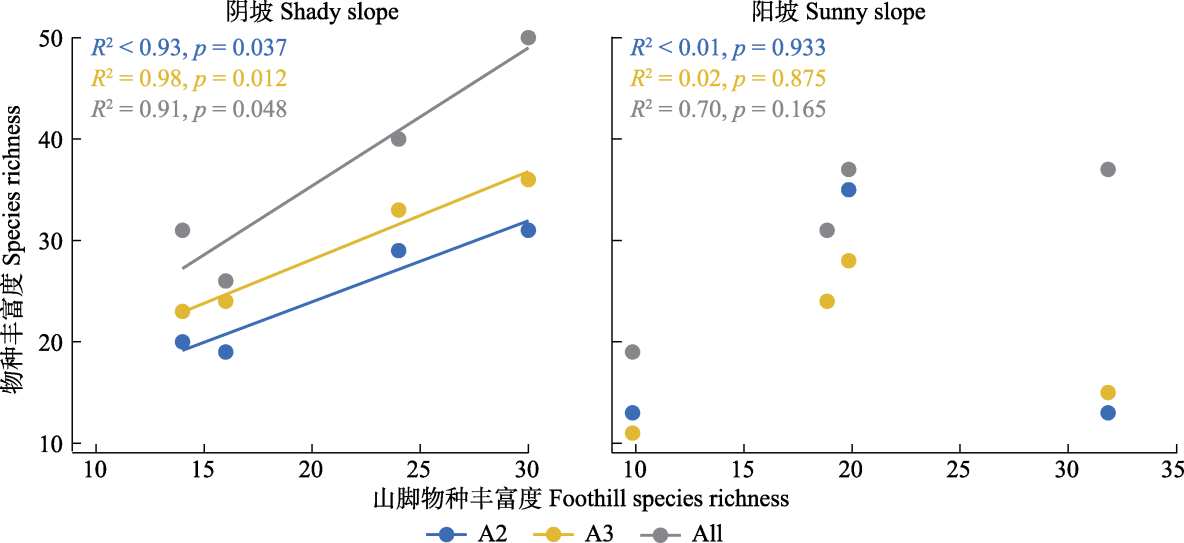
图6 绒布河流域尺度上, 不同山体山脚累计物种丰富度和山体中上部以及山体累计物种丰富度的关系。A2、A3和All, 分别表示山体中部、上部和整个山体内的区域。
Fig. 6 Relationship between cumulative species richness in the base zone and cumulative species richness in the middle and upper parts of mountains within the Rongbu River watershed. A2, A3, and All represent regions within the middle part and upper part of the mountain, and the entire mountain, respectively.
| [1] | Barry RG (2008) Mountain Weather and Climate. 3rd ed. Cambridge University Press, New York. |
| [2] | Cheng C, He N, Li M, Xu L, Cai W, Li X, Zhao W, Li C, Sun OJ (2023). Plant species richness on the Tibetan Plateau: patterns and determinants. Ecography, 2023, e06265. DOI: 10.1111/ecog.06265. |
| [3] | Chi XL, Tang ZY (2011). Effects of area, temperature and geometric constraints on elevational patterns of species richness: a case study in the Mountain Taibai, Qinling Mountains, China, Chinese Journal of Plant Ecology, 35, 362-370. |
|
[池秀莲, 唐志尧 (2011). 面积、温度及分布区限制对物种丰富度海拔格局的影响: 以秦岭太白山为例. 植物生态学报, 35, 362-370.]
DOI |
|
| [4] | Ding WN, Ree RH, Spicer RA, Xing YW (2020). Ancient orogenic and monsoon-driven assembly of the world’s richest temperate alpine flora. Science, 369, 578-581. |
| [5] | Dorji T, Moe SR, Klein JA, Totland Ø (2014). Plant species richness, evenness, and composition along environmental gradients in an alpine meadow grazing ecosystem in central Tibet, China. Arctic, Antarctic, and Alpine Research, 46, 308-326. |
| [6] |
Fang JY, Kanzaki M, Wang XP, Yoda K, Sun SZ, Shimota K (2004). Community structure of alpine sparse vegetation and effects of micro-topography in Pushila, Everest-Choyu region, Tibet, China. Biodiversity Science, 12, 190-199.
DOI |
|
[方精云, 神崎护, 王襄平, 依田恭二, 孙世洲, 下田胜久 (2004). 西藏珠峰-卓奥友峰普士拉地区高山稀疏植被的群落特征及小地形的影响. 生物多样性, 12, 190-199.]
DOI |
|
| [7] | Gaston KJ (2000). Global patterns in biodiversity. Nature, 405, 220-227. |
| [8] | He JS, Chen WL (1997). A review of gradient changes in species in species diversity of land plant communities. Acta Ecologica Sinica, 17, 91-98. |
| [贺金生, 陈伟烈 (1997). 陆地植物群落物种多样性的梯度变化特征. 生态学报, 17, 91-98.] | |
| [9] | Körner C (2000). Why are there global gradients in species richness? Mountains might hold the answer. Trends in Ecology & Evolution, 15, 513-514. |
| [10] | Körner C (2007). The use of ‘altitude’ in ecological research. Trends in Ecology & Evolution, 22, 569-574. |
| [11] |
La D, Zhang YJ, Liu J, Cui LL, Pang YZ (2016). Spatial distribution patterns and environmental interpretation of plant species richness in the Lhasa Valley, Tibet. Acta Prataculturae Sinica, 25, 202-211.
DOI |
|
[拉多, 张燕杰, 刘杰, 崔玲玲, 庞有智 (2016) 拉萨河谷植物物种丰富度空间分布格局及其环境解释. 草业学报, 25, 202-211.]
DOI |
|
| [12] |
La Q, Zhaxi CR, Zhu WD, Xu M, Zhong Y (2014). Plant species-richness and association with environmental factors in the riparian zone of the Yarlung Zangbo River of Tibet, China. Biodiversity Science, 22, 337-347.
DOI |
|
[拉琼, 扎西次仁, 朱卫东, 许敏, 钟扬 (2014). 雅鲁藏布江河岸植物物种丰富度分布格局及其环境解释. 生物多样性, 22, 337-347.]
DOI |
|
| [13] | Li WH, Ganjurjav H, Cao XJ, Yan YL, Li Y, Luo WR, Hu GZ, Danjiu LB, He SC, Gao QZ (2017). Effects of altitude on plant productivity and species diversity in alpine meadows of northern Tibet. Acta Prataculturae Sinica, 26, 200-207. |
|
[栗文瀚, 干珠扎布, 曹旭娟, 闫玉龙, 李钰, 罗文蓉, 胡国铮, 旦久罗布, 何世丞, 高清竹 (2017). 海拔梯度对藏北高寒草地生产力和物种多样性的影响. 草业学报, 26, 200-207.]
DOI |
|
| [14] | Liu KM, Zheng Z, Gong DJ (2017). Elevational patterns of species richness and their underlying mechanism. Chinese Journal of Ecology, 36, 541-554. |
| [刘开明, 郑智, 龚大洁 (2017). 物种丰富度的垂直分布格局及其形成机制. 生态学杂志, 36, 541-554.] | |
| [15] |
Liu Z, Li Q, Chen DD, Zhai WT, Zhao L, Xu SX, Zhao XQ (2015). Patterns of plant species diversity along an altitudinal gradient and its effect on above-ground biomass in alpine meadows in Qinghai-Tibet Plateau. Biodiversity Science, 23, 451-462.
DOI |
|
[刘哲, 李奇, 陈懂懂, 翟文婷, 赵亮, 徐世晓, 赵新全 (2015). 青藏高原高寒草甸物种多样性的海拔梯度分布格局及对地上生物量的影响. 生物多样性, 23, 451-462.]
DOI |
|
| [16] | Meng FD, Wang CS, Zhang ZH, Chang XF, Wang SP (2013). Comparative study of monitoring methods about plant diversity and aboveground biomass of alpine grasslands in the Tibetan Plateau. Acat Botanica Boreali-Occidentalia Sinica, 33, 1923-1929. |
| [孟凡栋, 王常顺, 张振华, 常小峰, 汪诗平 (2013). 西藏高原高寒草地群落植物多样性和地上生物量监测方法的比较研究. 西北植物学报, 33, 1923-1929.] | |
| [17] | Meng FD, Wang CS, Zhu XX, Cui SJ, Wang Q, Zhou Y, Wang SP (2016). Sampling methods about species richness and aboveground biomass of Potentilla fruticosa shrub meadow on Tibetan Plateau. Chinese Journal of Ecology, 35, 3435-3442. |
| [孟凡栋, 王常顺, 朱小雪, 崔树娟, 王奇, 周阳, 汪诗平 (2016). 西藏高原金露梅灌丛草甸物种丰富度和生物量取样方法探讨. 生态学杂志, 35, 3435-3442.] | |
| [18] | Moeslund JE, Arge L, Bøcher PK, Dalgaard T, Svenning JC (2013). Topography as a driver of local terrestrial vascular plant diversity patterns. Nordic Journal of Botany, 31, 129-144. |
| [19] | Myers N, Mittermeier RA, Mittermeier CG, da Fonseca GA, Kent J (2000). Biodiversity hotspots for conservation priorities. Nature, 403, 853-858. |
| [20] | Niu YJ, Zhou JW, Yang SW, Wang GZ, Liu L, Hua LM (2017). Quantitative apportionment of slope aspect and altitude to soil moisture and temperature and plant distribution on alpine meadow. Chinese Journal of Applied Ecology, 28, 1489-1497. |
|
[牛钰杰, 周建伟, 杨思维, 王贵珍, 刘丽, 花立民 (2017). 坡向和海拔对高寒草甸山体土壤水热和植物分布格局的定量分解. 应用生态学报, 28, 1489-1497.]
DOI |
|
| [21] | Nogués-Bravo D, Araújo MB, Romdal T, Rahbek C (2008). Scale effects and human impact on the elevational species richness gradients. Nature, 453, 216-219. |
| [22] | O’Brien EM (2006). Biological relativity to water-energy dynamics. Journal of Biogeography, 33, 1868-1888. |
| [23] | Palmer MW, White PS (1994). Scale dependence and the species-area relationship. The American Naturalist, 144, 717-740. |
| [24] | Perring F (1959). Topographical gradients of chalk grassland. Journal of Ecology, 47, 447-481. |
| [25] | Rahbek C (1995). The elevational gradient of species richness: a uniform pattern? Ecography, 18, 200-205. |
| [26] | Rahbek C (2005). The role of spatial scale and the perception of large-scale species-richness patterns. Ecology Letters, 8, 224-239. |
| [27] | Rahbek C, Borregaard MK, Colwell RK, Dalsgaard B, Holt BG, Morueta-Holme N, Nogues-Bravo D, Whittaker RJ, Fjeldså J (2019). Humboldt’s Enigma: What causes global patterns of mountain biodiversity? Science, 365, 1108-1113. |
| [28] |
Shimono A, Zhou HK, Shen HH, Hirota M, Ohtsuka T, Tang YH (2010). Patterns of plant diversity at high altitudes on the Qinghai-Tibetan Plateau. Journal of Plant Ecology, 3, 1-7.
DOI |
| [29] | Stevens GC (1992). The elevational gradient in altitudinal range: an extension of Rapoport’s latitudinal rule to altitude. The American Naturalist, 140, 893-911. |
| [30] | Sundqvist MK, Sanders NJ, Wardle DA (2013). Community and ecosystem responses to elevational gradients: processes, mechanisms, and insights for global change. Annual Review of Ecology, Evolution, and Systematics, 44, 261-280. |
| [31] | Wang CT, Long RJ, Wang QJ, Ding LM, Wang MP (2007). Effects of altitude on plant-species diversity and productivity in an alpine meadow, Qinghai-Tibetan Plateau. Australian Journal of Botany, 55, 110-117. |
| [32] |
Wang ZH, Chen AP, Piao SL, Fang JY (2004). Pattern of species richness along an altitudinal gradient on Gaoligong Mountains, Southwest China. Biodiversity Science, 12, 82-88.
DOI |
|
[王志恒, 陈安平, 朴世龙, 方精云 (2004). 高黎贡山种子植物物种丰富度沿海拔梯度的变化. 生物多样性, 12, 82-88.]
DOI |
|
| [33] | Whittaker RJ, Willis KJ, Field R (2001). Scale and species richness: towards a general, hierarchical theory of species diversity. Journal of Biogeography, 28, 453-470. |
| [34] | Yang K, Jiang YX, Tang WJ, He J, Shao CK, Zhou X, Lu H, Chen YY, Li X, Shi JC (2023). A high-resolution near-surface meteorological forcing dataset for the Third Pole region (TPMFD, 1979-2022). National Tibetan Plateau/Third Pole Environment Data Center. DOI: 10.11888/Atmos.tpdc.300398. |
| [阳坤, 姜尧志, 唐文君, 何杰, 邵长坤, 周旭, 卢麾, 陈莹莹, 李新, 施建成 (2023). 第三极地区长时间序列高分辨率地面气象要素驱动数据集(TPMFD, 1979-2022). 国家青藏高原数据中心. DOI: 10.11888/Atmos.tpdc.300398.] | |
| [35] | Yao SC, Wang JS, Ding LB, Bao XT, Li C, Wang T, Liu WJ, Li YY (2018). Quantitative classification and ordination of grassland communities in Lhasa River Valley. Acta Ecologica Sinica, 38, 4779-4788. |
| [姚帅臣, 王景升, 丁陆彬, 包小婷, 李超, 王彤, 刘文婧, 李妍妍 (2018). 拉萨河谷草地群落的数量分类与排序. 生态学报, 38, 4779-4788.] | |
| [36] | Zhang XL, Dong SK, Guo XD, Han YH, Li HM, Feng J, Wang C, Liu QR (2015). Comparison of different sampling techniques for alpine grassland plant diversity on Qinghai-Tibet Plateau. Chinese Journal of Ecology, 34, 3568-3574. |
| [张晓蕾, 董世魁, 郭贤达, 韩雨晖, 李灏漫, 冯憬, 王琛, 刘全儒 (2015). 青藏高原高寒草地植物多样性调查方法的比较. 生态学杂志, 34, 3568-3574.] |
| [1] | 刘新月, 王立平, 刘春和, 孙艳丽, 刘鹏, 田赟, 贾昕, 查天山, 钱多. 北京不同林龄人工林生物量空间格局及其影响因素[J]. 植物生态学报, 2025, 49(6): 939-951. |
| [2] | 王惺琪, 范宇阳, 张维琛, 王博杰. 基于生态系统服务和景观形态的浑善达克沙地生态安全格局[J]. 植物生态学报, 2025, 49(12): 2030-2042. |
| [3] | 李晓花, 刘杰, 李丹丹, 张乐华. 濒危植物小溪洞杜鹃种群结构与动态特征[J]. 植物生态学报, 2025, 49(11): 1844-1857. |
| [4] | 陈炫铮, 朱耀军, 高居娟, 刘一凡, 王荣, 方涛, 罗芳丽, 薛伟, 于飞海. 植物-土壤反馈时空变异研究进展[J]. 植物生态学报, 2024, 48(8): 955-966. |
| [5] | 赵长兴, 赵维俊, 张兴林, 刘思敏, 牟文博, 刘金荣. 祁连山排露沟流域青海云杉种群种内竞争与促进作用分析[J]. 植物生态学报, 2022, 46(9): 1027-1037. |
| [6] | 陈世苹, 游翠海, 胡中民, 陈智, 张雷明, 王秋凤. 涡度相关技术及其在陆地生态系统通量研究中的应用[J]. 植物生态学报, 2020, 44(4): 291-304. |
| [7] | 韦博良, 袁志良, 牛帅, 刘霞, 贾宏汝, 叶永忠. 河南省宝天曼锐齿槲栎林树木死亡对空间格局及种间相关性的影响[J]. 植物生态学报, 2017, 41(4): 430-438. |
| [8] | 葛结林, 熊高明, 李家湘, 徐文婷, 赵常明, 卢志军, 李跃林, 谢宗强. 中国南方灌丛凋落物现存量[J]. 植物生态学报, 2017, 41(1): 5-13. |
| [9] | 张炜平,潘莎,贾昕,储诚进,肖洒,林玥,白燕远,王根轩. 植物间正相互作用对种群动态和群落结构的影响: 基于个体模型的研究进展[J]. 植物生态学报, 2013, 37(6): 571-582. |
| [10] | 徐丽,于书霞,何念鹏,温学发,石培礼,张扬建,代景忠,王若梦. 青藏高原高寒草地土壤碳矿化及其温度敏感性[J]. 植物生态学报, 2013, 37(11): 988-997. |
| [11] | 黄运峰,丁易,臧润国,李小成,邹正冲,韩文涛. 海南岛霸王岭热带低地雨林树木的空间格局[J]. 植物生态学报, 2012, 36(4): 269-280. |
| [12] | 宋同清, 彭晚霞, 曾馥平, 王克林, 覃文更, 谭卫宁, 刘璐, 杜虎, 鹿士杨. 木论喀斯特峰丛洼地森林群落空间格局及环境解释[J]. 植物生态学报, 2010, 34(3): 298-308. |
| [13] | 喻泓, 杨晓晖, 慈龙骏. 地表火对红花尔基沙地樟子松种群空间分布格局的影响[J]. 植物生态学报, 2009, 33(1): 71-80. |
| [14] | 林玥, 任坚毅, 岳明. 太白山红桦种群结构与空间分析[J]. 植物生态学报, 2008, 32(6): 1335-1345. |
| [15] | 李增加, 马友鑫, 李红梅, 彭明春, 刘文俊. 西双版纳土地利用/覆盖变化与地形的关系[J]. 植物生态学报, 2008, 32(5): 1091-1103. |
| 阅读次数 | ||||||
|
全文 |
|
|||||
|
摘要 |
|
|||||
Copyright © 2026 版权所有 《植物生态学报》编辑部
地址: 北京香山南辛村20号, 邮编: 100093
Tel.: 010-62836134, 62836138; Fax: 010-82599431; E-mail: apes@ibcas.ac.cn, cjpe@ibcas.ac.cn
备案号: 京ICP备16067583号-19
![]()