
植物生态学报 ›› 2008, Vol. 32 ›› Issue (5): 1091-1103.DOI: 10.3773/j.issn.1005-264x.2008.05.014
李增加1,2, 马友鑫1,*( ), 李红梅1, 彭明春3, 刘文俊1
收稿日期:2007-11-08
接受日期:2008-05-21
出版日期:2008-11-08
发布日期:2008-09-30
通讯作者:
马友鑫
作者简介:*(may@xtbg.ac.cn)基金资助:
LI Zeng-Jia1,2, MA You-Xin1,*(), LI Hong-Mei1, PENG Ming-Chun3, LIU Wun-Jun1
Received:2007-11-08
Accepted:2008-05-21
Online:2008-11-08
Published:2008-09-30
Contact:
MA You-Xin
摘要:
土地利用/覆盖变化是全球变化研究的重要领域。该文利用6个时期的MSS/TM/ETM影像和1:50 000DEM数据分析了1976~2007年西双版纳地区不同地形下的土地利用/覆盖变化动态, 结果表明: 1)31年间, 该区土地利用/覆盖变化剧烈, 有林地面积由1976年的69.0%下降到2007年的43.6%, 橡胶园面积由1976年的1.3%增加到2007年的11.8%; 2)有林地在海拔1 600 m以下不断减少, 而橡胶园的海拔分布上限则持续增加, 由1976年的1 000 m上升至2007年的1 400 m, 面积在400~1 000 m处占优。农业用地主要分布在海拔400~600 m, 在600 m之上迅速减少; 3)各坡度带上的有林地面积逐年减少, 橡胶园则逐年增加, 而灌木林与旱地则先升后降; 橡胶园、农业用地等主要分布在坡度较缓的区域, 坡度越大, 有林地越多; 1988年后, 橡胶园面积在坡度5°以下基本保持不变, 但在坡度大于5°的区域持续扩张; 4)坡向对橡胶园与农业用地等分布的影响较大, 南坡的橡胶发展最为迅速, 且有向北坡发展的趋势。有林地在北坡分布比例较大, 旱地在北坡分布比例较小。人口增加与橡胶园和茶园等经济种植园的不断扩展是导致西双版纳土地利用/覆盖变化的直接因素。要实现西双版纳的可持续发展, 必须控制经济种植园的盲目扩张, 科学合理垦殖, 保护热带森林。
李增加, 马友鑫, 李红梅, 彭明春, 刘文俊. 西双版纳土地利用/覆盖变化与地形的关系. 植物生态学报, 2008, 32(5): 1091-1103. DOI: 10.3773/j.issn.1005-264x.2008.05.014
LI Zeng-Jia, MA You-Xin, LI Hong-Mei, PENG Ming-Chun, LIU Wun-Jun. RELATION OF LAND USE AND COVER CHANGE TO TOPOGRAPHY IN XISHUANGBANNA, SOUTHWEST CHINA. Chinese Journal of Plant Ecology, 2008, 32(5): 1091-1103. DOI: 10.3773/j.issn.1005-264x.2008.05.014
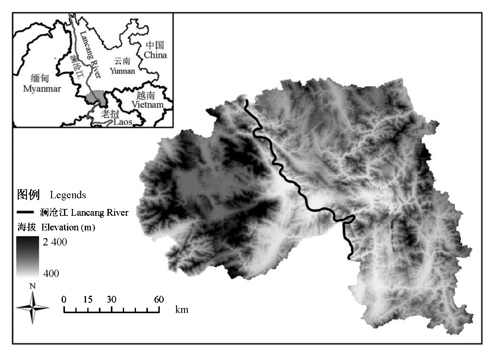
图1 研究区地理位置和地形
Fig. 1 Location and topography of study area
| 类型 Type | A1 | A2 | A3 | A4 | A5 | A6 | A7 | A8 | A9 | A10 | A11 | Xi+ | UA (%) |
|---|---|---|---|---|---|---|---|---|---|---|---|---|---|
| A1 | 69 | 5 | 1 | 2 | 1 | 78 | 88.5 | ||||||
| A2 | 1 | 27 | 1 | 29 | 93.1 | ||||||||
| A3 | 11 | 43 | 1 | 1 | 2 | 58 | 74.1 | ||||||
| A4 | 1 | 75 | 7 | 83 | 90.4 | ||||||||
| A5 | 1 | 6 | 1 | 8 | 75.0 | ||||||||
| A6 | 1 | 40 | 1 | 42 | 95.2 | ||||||||
| A7 | 1 | 9 | 1 | 11 | 95.2 | ||||||||
| A8 | 1 | 2 | 2 | 31 | 3 | 1 | 40 | 81.8 | |||||
| A9 | 1 | 1 | 25 | 27 | 77.5 | ||||||||
| A10 | 1 | 13 | 14 | 92.9 | |||||||||
| A11 | 2 | 8 | 10 | 80.0 | |||||||||
| X+i | 70 | 49 | 47 | 78 | 9 | 41 | 9 | 42 | 29 | 16 | 10 | OA=86.5 | |
| PA (%) | 98.6 | 55.1 | 91.5 | 96.2 | 66.7 | 97.6 | 100 | 73.8 | 86.2 | 81.3 | 80.0 | ||
表1 2007年各土地利用/覆盖类型之间的误差矩阵
Table 1 Error matrix of all land use/cover types in study area
| 类型 Type | A1 | A2 | A3 | A4 | A5 | A6 | A7 | A8 | A9 | A10 | A11 | Xi+ | UA (%) |
|---|---|---|---|---|---|---|---|---|---|---|---|---|---|
| A1 | 69 | 5 | 1 | 2 | 1 | 78 | 88.5 | ||||||
| A2 | 1 | 27 | 1 | 29 | 93.1 | ||||||||
| A3 | 11 | 43 | 1 | 1 | 2 | 58 | 74.1 | ||||||
| A4 | 1 | 75 | 7 | 83 | 90.4 | ||||||||
| A5 | 1 | 6 | 1 | 8 | 75.0 | ||||||||
| A6 | 1 | 40 | 1 | 42 | 95.2 | ||||||||
| A7 | 1 | 9 | 1 | 11 | 95.2 | ||||||||
| A8 | 1 | 2 | 2 | 31 | 3 | 1 | 40 | 81.8 | |||||
| A9 | 1 | 1 | 25 | 27 | 77.5 | ||||||||
| A10 | 1 | 13 | 14 | 92.9 | |||||||||
| A11 | 2 | 8 | 10 | 80.0 | |||||||||
| X+i | 70 | 49 | 47 | 78 | 9 | 41 | 9 | 42 | 29 | 16 | 10 | OA=86.5 | |
| PA (%) | 98.6 | 55.1 | 91.5 | 96.2 | 66.7 | 97.6 | 100 | 73.8 | 86.2 | 81.3 | 80.0 | ||
| 级别 Grade | 海拔 Elevation (m) | 坡度 Slope (°) | 坡向 Aspect |
|---|---|---|---|
| 1 | 400~600 | <5 | 平地 Flat |
| 2 | 600~800 | 5~8 | 北 North |
| 3 | 800~1 000 | 8~15 | 东 East |
| 4 | 1 000~1 200 | 15~25 | 南 South |
| 5 | 1 200~1 400 | 25~35 | 西 West |
| 6 | 1 400~1 600 | >35 | |
| 7 | 1 600~1 800 | ||
| 8 | 1 800~2 000 | ||
| 9 | >2 000 |
表2 地形因子分级
Table 2 Classification of different topographic factors
| 级别 Grade | 海拔 Elevation (m) | 坡度 Slope (°) | 坡向 Aspect |
|---|---|---|---|
| 1 | 400~600 | <5 | 平地 Flat |
| 2 | 600~800 | 5~8 | 北 North |
| 3 | 800~1 000 | 8~15 | 东 East |
| 4 | 1 000~1 200 | 15~25 | 南 South |
| 5 | 1 200~1 400 | 25~35 | 西 West |
| 6 | 1 400~1 600 | >35 | |
| 7 | 1 600~1 800 | ||
| 8 | 1 800~2 000 | ||
| 9 | >2 000 |
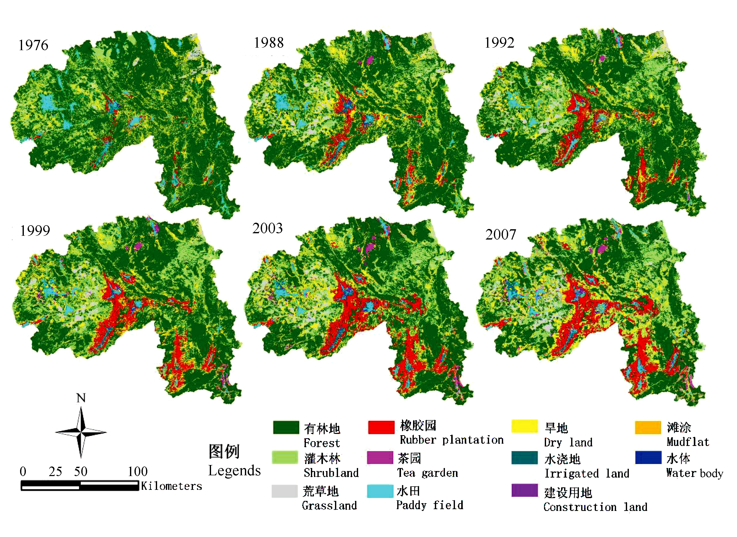
图2 1976~2007年西双版纳地区土地利用/覆盖变化
Fig. 2 Land use/cover changes in Xishuangbanna from1976 to 2007
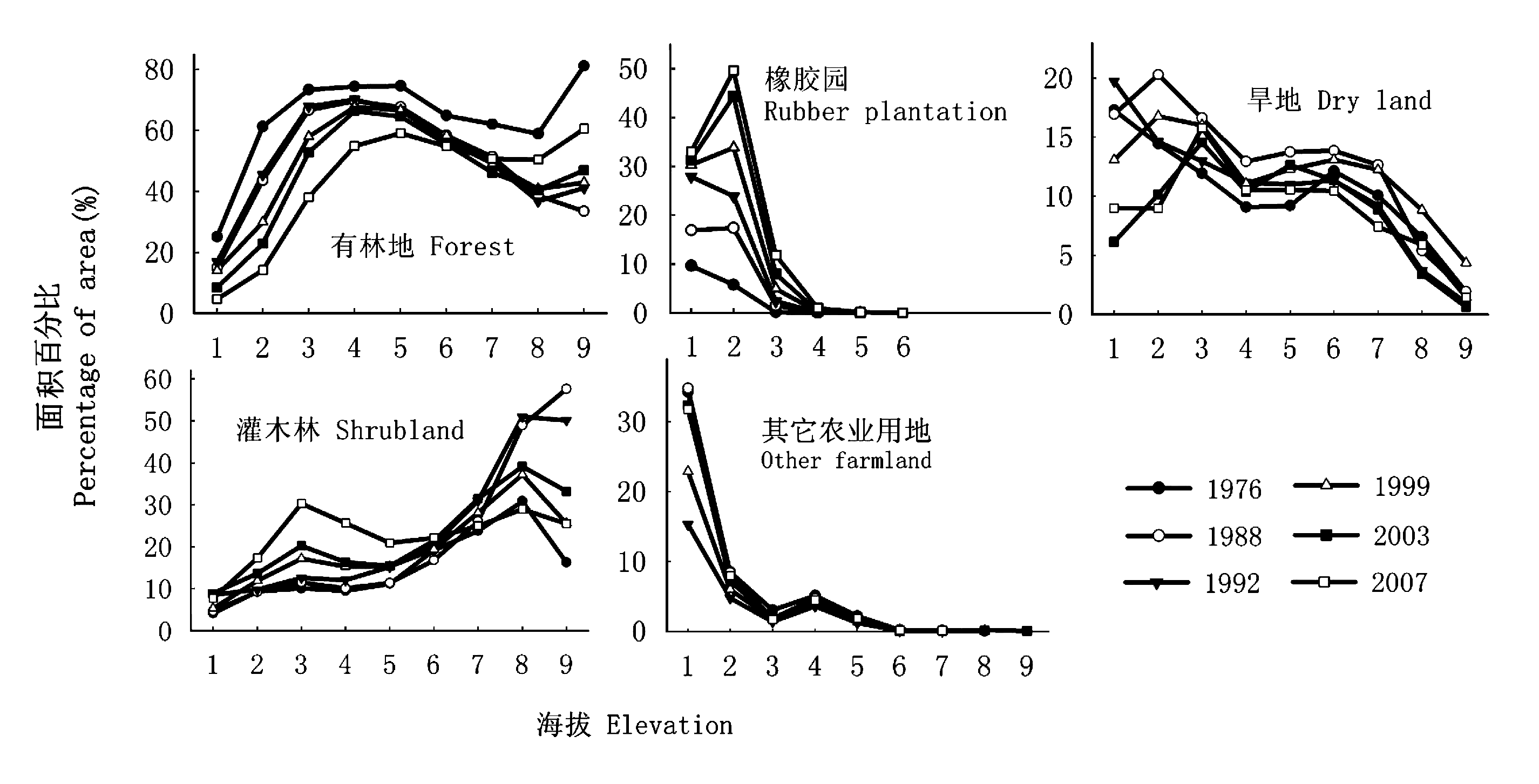
图3 各高程带上的不同土地利用/覆盖类型的面积百分比 其它农业用地包括水田与水浇地 Other farmland includes paddy field and irrigated land
Fig. 3 Area percentage of land use/cover types in different elevation gradients
| 海拔段 Altitude (m) | 总面积 Total area (hm2) | 土地利用/覆盖类型 Land use/cover types | 年变化率 Annual change in percentage (%) | ||||
|---|---|---|---|---|---|---|---|
| 1976~1988 | 1988~1992 | 1992~1999 | 1999~2003 | 2003~2007 | |||
| <600 | 56 162 | 有林地 Forest | -0.85 | 0.49 | -0.39 | -1.38 | -0.95 |
| 灌木林地 Shrubland | 0.05 | 0.95 | -0.43 | 0.85 | -0.28 | ||
| 橡胶园 Rubber plantation | 0.61 | 2.76 | 0.34 | 0.27 | 0.39 | ||
| 农业用地 Farmland | 0.02 | -3.77 | 0.22 | 0.09 | 0.56 | ||
| 建设用地 Construction land | - | 0.04 | 0.26 | 0.24 | 0.14 | ||
| 600~1 000 | 735 674 | 有林地 Forest | -0.94 | 0.37 | -1.76 | -1.48 | -3.04 |
| 灌木林地 Shrubland | 0.06 | 0.22 | 0.50 | 0.63 | 1.86 | ||
| 橡胶园 Rubber plantation | 0.47 | 0.81 | 0.80 | 1.55 | 1.10 | ||
| 农业用地 Farmland | 0.38 | -1.50 | 0.55 | -0.74 | 0.19 | ||
| 建设用地 Construction land | - | 0.05 | 0.00 | 0.02 | 0.00 | ||
| 1 000~1 400 | 820 524 | 有林地 Forest | -0.47 | -0.04 | -0.21 | -0.40 | -2.24 |
| 灌木林地 Shrubland | 0.04 | 0.69 | 0.27 | 0.16 | 1.92 | ||
| 橡胶园 Rubber plantation | 0.00 | 0.00 | 0.01 | 0.01 | 0.11 | ||
| 农业用地 Farmland | 0.34 | -0.76 | 0.19 | 0.16 | 0.27 | ||
| 建设用地 Construction land | - | 0.01 | 0.00 | 0.01 | 0.00 | ||
| >1 400 | 302 905 | 有林地 Forest | -0.84 | -0.41 | 0.18 | -0.59 | 0.56 |
| 灌木林地 Shrubland | 0.18 | 0.92 | -0.49 | 0.63 | -0.68 | ||
| 橡胶园 Rubber plantation | 0.00 | 0.00 | 0.00 | 0.00 | 0.00 | ||
| 农业用地 Farmland | 0.14 | -0.58 | 0.44 | -0.29 | -0.45 | ||
| 建设用地 Construction land | - | 0.01 | 0.00 | 0.00 | 0.00 | ||
表3 1976~2007年西双版纳地区不同海拔土地利用/覆盖类型的年变化率
Table 3 Annual changes in percentage of land use/cover at various altitude gradients from 1976 to 2007
| 海拔段 Altitude (m) | 总面积 Total area (hm2) | 土地利用/覆盖类型 Land use/cover types | 年变化率 Annual change in percentage (%) | ||||
|---|---|---|---|---|---|---|---|
| 1976~1988 | 1988~1992 | 1992~1999 | 1999~2003 | 2003~2007 | |||
| <600 | 56 162 | 有林地 Forest | -0.85 | 0.49 | -0.39 | -1.38 | -0.95 |
| 灌木林地 Shrubland | 0.05 | 0.95 | -0.43 | 0.85 | -0.28 | ||
| 橡胶园 Rubber plantation | 0.61 | 2.76 | 0.34 | 0.27 | 0.39 | ||
| 农业用地 Farmland | 0.02 | -3.77 | 0.22 | 0.09 | 0.56 | ||
| 建设用地 Construction land | - | 0.04 | 0.26 | 0.24 | 0.14 | ||
| 600~1 000 | 735 674 | 有林地 Forest | -0.94 | 0.37 | -1.76 | -1.48 | -3.04 |
| 灌木林地 Shrubland | 0.06 | 0.22 | 0.50 | 0.63 | 1.86 | ||
| 橡胶园 Rubber plantation | 0.47 | 0.81 | 0.80 | 1.55 | 1.10 | ||
| 农业用地 Farmland | 0.38 | -1.50 | 0.55 | -0.74 | 0.19 | ||
| 建设用地 Construction land | - | 0.05 | 0.00 | 0.02 | 0.00 | ||
| 1 000~1 400 | 820 524 | 有林地 Forest | -0.47 | -0.04 | -0.21 | -0.40 | -2.24 |
| 灌木林地 Shrubland | 0.04 | 0.69 | 0.27 | 0.16 | 1.92 | ||
| 橡胶园 Rubber plantation | 0.00 | 0.00 | 0.01 | 0.01 | 0.11 | ||
| 农业用地 Farmland | 0.34 | -0.76 | 0.19 | 0.16 | 0.27 | ||
| 建设用地 Construction land | - | 0.01 | 0.00 | 0.01 | 0.00 | ||
| >1 400 | 302 905 | 有林地 Forest | -0.84 | -0.41 | 0.18 | -0.59 | 0.56 |
| 灌木林地 Shrubland | 0.18 | 0.92 | -0.49 | 0.63 | -0.68 | ||
| 橡胶园 Rubber plantation | 0.00 | 0.00 | 0.00 | 0.00 | 0.00 | ||
| 农业用地 Farmland | 0.14 | -0.58 | 0.44 | -0.29 | -0.45 | ||
| 建设用地 Construction land | - | 0.01 | 0.00 | 0.00 | 0.00 | ||
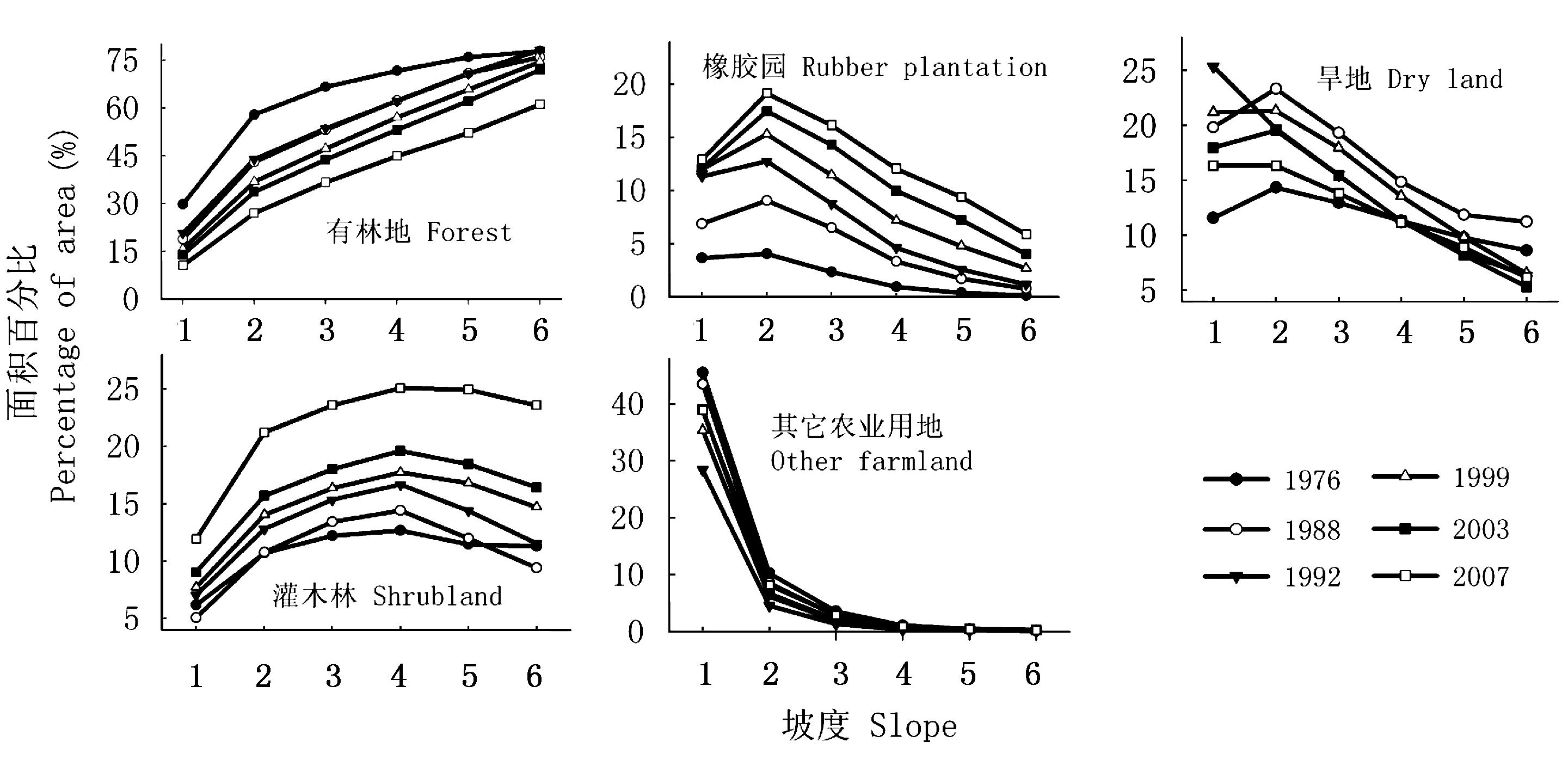
图4 各坡度带上的不同土地利用/覆盖类型的面积百分比 其它农业用地包括水田与水浇地 Other farmland includes paddy field and irrigated land
Fig. 4 Area percentage of land use/cover types in different slope gradients
| 坡度 Slope (°) | 总面积 Total area (hm2) | 土地利用/覆盖类型 Land use/cover types | 年变化率 Annual changes in percentage (%) | ||||
|---|---|---|---|---|---|---|---|
| 1976~1988 | 1988~1992 | 1992~1999 | 1999~2003 | 2003~2007 | |||
| <5 | 136 664 | 有林地 Forest | -0.92 | 0.48 | -0.72 | -0.43 | -0.85 |
| 灌木林地 Shrubland | -0.09 | 0.49 | 0.10 | 0.33 | 0.72 | ||
| 橡胶园 Rubber plantation | 0.27 | 1.11 | 0.10 | 0.03 | 0.19 | ||
| 农业用地 Farmland | 0.57 | -2.14 | 0.47 | -0.04 | -0.22 | ||
| 建设用地 Construction land | - | 0.12 | 0.13 | 0.14 | 0.06 | ||
| 5~15 | 347 156 | 有林地 Forest | -1.14 | 0.11 | -0.91 | -0.85 | -1.76 |
| 灌木林地 Shrubland | 0.08 | 0.49 | 0.15 | 0.41 | 1.39 | ||
| 橡胶园 Rubber plantation | 0.36 | 0.64 | 0.38 | 0.68 | 0.45 | ||
| 农业用地 Farmland | 0.54 | -1.35 | 0.54 | -0.32 | 0.00 | ||
| 建设用地 Construction land | 0.01 | 0.04 | 0.01 | 0.01 | 0.00 | ||
| 15~25 | 793 236 | 有林地 Forest | -0.78 | -0.03 | -0.74 | -0.98 | -2.04 |
| 灌木林地 Shrubland | 0.15 | 0.56 | 0.15 | 0.47 | 1.36 | ||
| 橡胶园 Rubber plantation | 0.20 | 0.32 | 0.37 | 0.70 | 0.52 | ||
| 农业用地 Farmland | 0.28 | -0.94 | 0.41 | -0.32 | 0.15 | ||
| 建设用地 Construction land | - | 0.01 | 0.00 | 0.01 | 0.00 | ||
| 25~35 | 505 351 | 有林地 Forest | -0.43 | -0.01 | -0.72 | -0.90 | -2.50 |
| 灌木林地 Shrubland | 0.04 | 0.60 | 0.34 | 0.42 | 1.62 | ||
| 橡胶园 Rubber plantation | 0.11 | 0.21 | 0.32 | 0.62 | 0.53 | ||
| 农业用地 Farmland | 0.17 | -0.87 | 0.25 | -0.21 | 0.27 | ||
| 建设用地 Construction land | - | 0.01 | 0.00 | 0.01 | 0.00 | ||
| >35 | 132 858 | 有林地 Forest | -0.15 | 0.54 | -0.52 | -0.65 | -2.68 |
| 灌木林地 Shrubland | -0.16 | 0.53 | 0.45 | 0.43 | 1.79 | ||
| 橡胶园 Rubber plantation | 0.05 | 0.10 | 0.21 | 0.34 | 0.46 | ||
| 农业用地 Farmland | 0.22 | -1.22 | 0.05 | -0.15 | 0.27 | ||
| 建设用地 Construction land | - | 0.00 | 0.00 | 0.00 | 0.00 | ||
表4 1976~2007年西双版纳地区不同坡度土地利用/覆盖类型的年变化率
Table 4 Annual changes in percentage of land use/cover along different slope gradients from 1976 to 2007
| 坡度 Slope (°) | 总面积 Total area (hm2) | 土地利用/覆盖类型 Land use/cover types | 年变化率 Annual changes in percentage (%) | ||||
|---|---|---|---|---|---|---|---|
| 1976~1988 | 1988~1992 | 1992~1999 | 1999~2003 | 2003~2007 | |||
| <5 | 136 664 | 有林地 Forest | -0.92 | 0.48 | -0.72 | -0.43 | -0.85 |
| 灌木林地 Shrubland | -0.09 | 0.49 | 0.10 | 0.33 | 0.72 | ||
| 橡胶园 Rubber plantation | 0.27 | 1.11 | 0.10 | 0.03 | 0.19 | ||
| 农业用地 Farmland | 0.57 | -2.14 | 0.47 | -0.04 | -0.22 | ||
| 建设用地 Construction land | - | 0.12 | 0.13 | 0.14 | 0.06 | ||
| 5~15 | 347 156 | 有林地 Forest | -1.14 | 0.11 | -0.91 | -0.85 | -1.76 |
| 灌木林地 Shrubland | 0.08 | 0.49 | 0.15 | 0.41 | 1.39 | ||
| 橡胶园 Rubber plantation | 0.36 | 0.64 | 0.38 | 0.68 | 0.45 | ||
| 农业用地 Farmland | 0.54 | -1.35 | 0.54 | -0.32 | 0.00 | ||
| 建设用地 Construction land | 0.01 | 0.04 | 0.01 | 0.01 | 0.00 | ||
| 15~25 | 793 236 | 有林地 Forest | -0.78 | -0.03 | -0.74 | -0.98 | -2.04 |
| 灌木林地 Shrubland | 0.15 | 0.56 | 0.15 | 0.47 | 1.36 | ||
| 橡胶园 Rubber plantation | 0.20 | 0.32 | 0.37 | 0.70 | 0.52 | ||
| 农业用地 Farmland | 0.28 | -0.94 | 0.41 | -0.32 | 0.15 | ||
| 建设用地 Construction land | - | 0.01 | 0.00 | 0.01 | 0.00 | ||
| 25~35 | 505 351 | 有林地 Forest | -0.43 | -0.01 | -0.72 | -0.90 | -2.50 |
| 灌木林地 Shrubland | 0.04 | 0.60 | 0.34 | 0.42 | 1.62 | ||
| 橡胶园 Rubber plantation | 0.11 | 0.21 | 0.32 | 0.62 | 0.53 | ||
| 农业用地 Farmland | 0.17 | -0.87 | 0.25 | -0.21 | 0.27 | ||
| 建设用地 Construction land | - | 0.01 | 0.00 | 0.01 | 0.00 | ||
| >35 | 132 858 | 有林地 Forest | -0.15 | 0.54 | -0.52 | -0.65 | -2.68 |
| 灌木林地 Shrubland | -0.16 | 0.53 | 0.45 | 0.43 | 1.79 | ||
| 橡胶园 Rubber plantation | 0.05 | 0.10 | 0.21 | 0.34 | 0.46 | ||
| 农业用地 Farmland | 0.22 | -1.22 | 0.05 | -0.15 | 0.27 | ||
| 建设用地 Construction land | - | 0.00 | 0.00 | 0.00 | 0.00 | ||
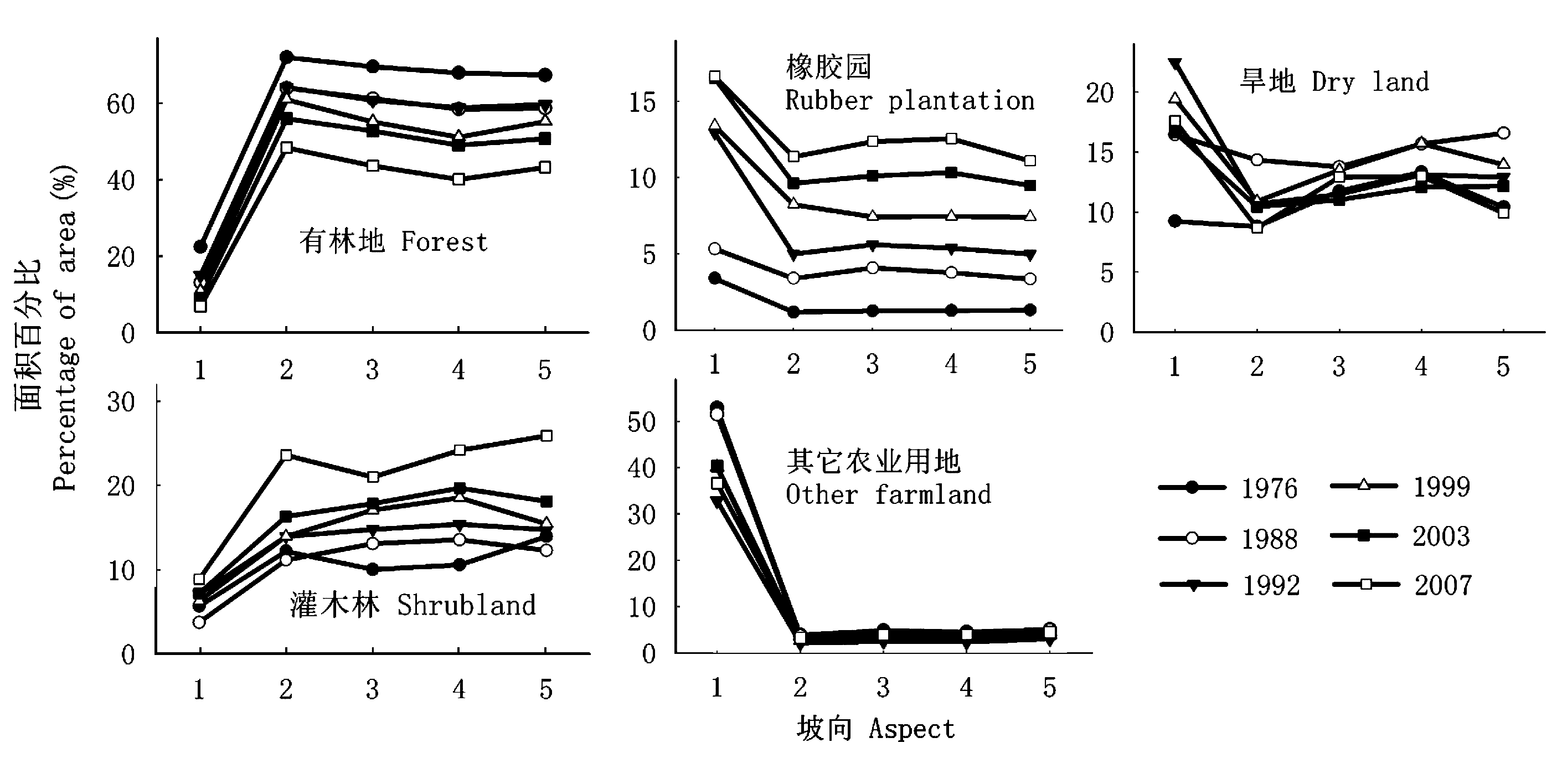
图5 各坡向上的不同土地利用/覆盖类型的面积百分比 其它农业用地包括水田与水浇地 Other farmland includes paddy field and irrigated land
Fig. 5 Area percentage of land use/cover types in different aspects
| 坡向 Aspect | 总面积 Total area (hm2) | 土地利用/覆盖类型 Land use/cover types | 年变化率 Annual changes in percentage (%) | ||||
|---|---|---|---|---|---|---|---|
| 1976~1988 | 1988~1992 | 1992~1999 | 1999~2003 | 2003~2007 | |||
| 平地 Flat | 6 904 | 有林地 Forest | -0.78 | 0.48 | -0.59 | -0.45 | -0.54 |
| 灌木林 Shrubland | -0.16 | 0.84 | -0.11 | 0.22 | 0.42 | ||
| 橡胶园 Rubber plantation | 0.16 | 0.45 | 0.13 | 0.11 | 0.16 | ||
| 农业用地 Farmland | 0.51 | -1.64 | 0.47 | 0.03 | -0.44 | ||
| 北坡 North | 493 468 | 有林地 Forest | -0.67 | 0.06 | -0.45 | -1.26 | -1.90 |
| 灌木林 Shrubland | -0.09 | 0.70 | 0.00 | 0.59 | 1.82 | ||
| 橡胶园 Rubber plantation | 0.19 | 0.40 | 0.46 | 0.35 | 0.44 | ||
| 农业用地 Farmland | 0.45 | -1.22 | 0.16 | 0.13 | -0.32 | ||
| 东坡 East | 447 575 | 有林地 Forest | -0.70 | -0.10 | -0.80 | -0.60 | -2.29 |
| 灌木林 Shrubland | 0.25 | 0.43 | 0.32 | 0.19 | 0.79 | ||
| 橡胶园 Rubber plantation | 0.23 | 0.38 | 0.26 | 0.67 | 0.56 | ||
| 农业用地 Farmland | 0.11 | -0.87 | 0.42 | -0.30 | 0.86 | ||
| 南坡 South | 508 489 | 有林地 Forest | -0.79 | 0.07 | -1.09 | -0.53 | -2.23 |
| 灌木林 Shrubland | 0.25 | 0.45 | 0.45 | 0.28 | 1.13 | ||
| 橡胶园 Rubber plantation | 0.21 | 0.40 | 0.24 | 0.82 | 0.53 | ||
| 农业用地 Farmland | 0.18 | -1.00 | 0.54 | -0.58 | 0.48 | ||
| 西坡 West | 458 829 | 有林地 Forest | -0.72 | 0.26 | -0.64 | -1.11 | -1.89 |
| 灌木林 Shrubland | -0.14 | 0.62 | 0.10 | 0.67 | 1.94 | ||
| 橡胶园 Rubber plantation | 0.17 | 0.41 | 0.35 | 0.52 | 0.40 | ||
| 农业用地 Farmland | 0.51 | -1.34 | 0.34 | -0.24 | -0.44 | ||
表5 1976~2007年西双版纳地区不同坡向土地利用/覆盖类型的年变化率
Table 5 Annual changes in percentage of land use/cover at different aspects from 1976 to 2007
| 坡向 Aspect | 总面积 Total area (hm2) | 土地利用/覆盖类型 Land use/cover types | 年变化率 Annual changes in percentage (%) | ||||
|---|---|---|---|---|---|---|---|
| 1976~1988 | 1988~1992 | 1992~1999 | 1999~2003 | 2003~2007 | |||
| 平地 Flat | 6 904 | 有林地 Forest | -0.78 | 0.48 | -0.59 | -0.45 | -0.54 |
| 灌木林 Shrubland | -0.16 | 0.84 | -0.11 | 0.22 | 0.42 | ||
| 橡胶园 Rubber plantation | 0.16 | 0.45 | 0.13 | 0.11 | 0.16 | ||
| 农业用地 Farmland | 0.51 | -1.64 | 0.47 | 0.03 | -0.44 | ||
| 北坡 North | 493 468 | 有林地 Forest | -0.67 | 0.06 | -0.45 | -1.26 | -1.90 |
| 灌木林 Shrubland | -0.09 | 0.70 | 0.00 | 0.59 | 1.82 | ||
| 橡胶园 Rubber plantation | 0.19 | 0.40 | 0.46 | 0.35 | 0.44 | ||
| 农业用地 Farmland | 0.45 | -1.22 | 0.16 | 0.13 | -0.32 | ||
| 东坡 East | 447 575 | 有林地 Forest | -0.70 | -0.10 | -0.80 | -0.60 | -2.29 |
| 灌木林 Shrubland | 0.25 | 0.43 | 0.32 | 0.19 | 0.79 | ||
| 橡胶园 Rubber plantation | 0.23 | 0.38 | 0.26 | 0.67 | 0.56 | ||
| 农业用地 Farmland | 0.11 | -0.87 | 0.42 | -0.30 | 0.86 | ||
| 南坡 South | 508 489 | 有林地 Forest | -0.79 | 0.07 | -1.09 | -0.53 | -2.23 |
| 灌木林 Shrubland | 0.25 | 0.45 | 0.45 | 0.28 | 1.13 | ||
| 橡胶园 Rubber plantation | 0.21 | 0.40 | 0.24 | 0.82 | 0.53 | ||
| 农业用地 Farmland | 0.18 | -1.00 | 0.54 | -0.58 | 0.48 | ||
| 西坡 West | 458 829 | 有林地 Forest | -0.72 | 0.26 | -0.64 | -1.11 | -1.89 |
| 灌木林 Shrubland | -0.14 | 0.62 | 0.10 | 0.67 | 1.94 | ||
| 橡胶园 Rubber plantation | 0.17 | 0.41 | 0.35 | 0.52 | 0.40 | ||
| 农业用地 Farmland | 0.51 | -1.34 | 0.34 | -0.24 | -0.44 | ||
| [1] | Fang JY (方精云), Shen ZH (沈泽昊), Cui HT (崔海亭) (2004). Ecological characteristics of mountains and research issues of mountain ecology. Biodiversity Science (生物多样性), 12,10-19. (in Chinese with English abstract) |
| [2] | Feng CY (冯朝阳), Yu Y (于勇), Gao JX (高吉喜), Han YW (韩永伟) (2007). Influences of topographic on distribution and change of land use and cover in Mentougou district, Beijing. Journal of Mountain Science (山地学报), 25,274-279. (in Chinese with English abstract) |
| [3] |
Foley JA, DeFries R, Asner GP, Barford C, Bonan G, Carpenter SR, Chapin FS, Coe MT, Daily GC, Gibbs HK, Helkowski JH, Holloway T, Howard EA, Kucharik CJ, Monfreda C, Patz JA, Prentice LC, Ramankutty N, Snyder PK (2005). Global consequences of land use. Science, 309,570-574.
DOI URL PMID |
| [4] |
Fox J, Vogler JB (2005). Land-use and land-cover change in montane mainland Southeast Asia. Environmental Management, 36,394-403.
URL PMID |
| [5] | Gong SX (宫世贤), Ling SH (凌升海) (1996). Fog decreasing in Xishuangbanna region. Meteorological Monthly (气象), 22(11),10-14. (in Chinese with English abstract) |
| [6] | He YL (何云玲), Zhang YP (张一平), Yang XB (杨小波) (2007). Climate change in tropical area of southern China since 1950s. Scientia Geographica Sinica (地理科学), 27,499-505. (in Chinese with English abstract) |
| [7] | Hietel E, Waldhardt R, Otte A (2004). Analysing land-cover changes in relation to environmental variables in Hesse, Germany. Landscape Ecology, 19,473-489. |
| [8] | International Rubber Study Group (2007). Statistical Summary of World Rubber Situation. http://www.rubberstudy.com/statistics-quarstat.aspx. Cited 20 Jan 2008. |
| [9] | Jiang AL (江爱良), Qian P (钱平) (1985). A study of the relationship between nocturnal cooling process in winter on different-facing slopes in Xishuangbanna and the chilling injury of rubber trees. Chinese Journal of Tropical Crops (热带作物学报), 6(2),1-12. (in Chinese with English abstract) |
| [10] | Jiang XB (江晓波), Ma ZZ (马泽忠), Zeng WR (曾文蓉), Zhou WC (周万村), Zhou AX (周爱霞), Li AN (李爱农), Sun YQ (孙育秋) (2004). Land-use/cover change process and driving force analysis in three gorges area. Journal of Soil and Water Conservation (水土保持学报), 18(4),108-112. (in Chinese with English abstract) |
| [11] | Lambin EF, Turner BL, Geist HJ, Agbola SB, Angelsen A, Bruce JW, Coomes OT, Dirzo R, Fischer G, Folke C, George PS, Homewood K, Imbernon J, Leemans R, Li XB, Moran EF, Mortimore M, Ramakrishnan PS, Richards JF, Skanes H, Steffen W, Stone GD, Svedin U, Veldkamp TA, Vogel C, Xu JC (2001). The causes of land-use and land-cover change: moving beyond the myths. Global Environmental Change, 11,261-269. |
| [12] | Lan GY (兰国玉), Hu YH (胡跃华), Cao M (曹敏), Zhu H (朱华), Wang H (王洪), Zhou SS (周仕顺), Deng XB (邓晓保), Cui JY (崔景云), Huang JG (黄建国), Liu LY (刘林云), Xu HL (许海龙), Song JP (宋军平), He YC (何有才) (2008). Establishment of Xishuangbanna tropical forest dynamics plot: Species compositions and spatial distribution patterns. Acta Phytoecologica Sinica(植物生态学报), 32,287-298. (in Chinese with English abstract) |
| [13] | Li HM (李红梅), Ma YX (马友鑫), Guo ZF (郭宗峰), Liu WJ (刘文俊) (2007). Land use/land cover dynamic change in Xishuangbanna based on RS and GIS technology. Journal of Mountain Science(山地学报), 25,280-289. (in Chinese with English abstract) |
| [14] | Li HM, Aide TM, Ma YX, Liu WJ, Cao M (2007). Demand for rubber is causing the loss of high diversity rain forest in SW China. Biodiversity and Conservation, 16,1731-1745. |
| [15] | Liu DW (刘殿伟), Song KS (宋开山), Wang DD (王丹丹), Zhang SQ (张树清) (2006). Dynamic change of land-use patterns in west part of Songnen Plain. Scientia Geographica Sinica (地理科学), 26,277-283. (in Chinese with English abstract) |
| [16] | Liu WJ (刘文杰), Zhang YP (张一平), Liu YH (刘玉洪), Li HM (李红梅), Duan WP (段文平) (2003). Comparison of fog interception at a tropical seasonal rain forest and a rubber plantation in Xishuangbanna, Southwest China. Acta Ecologica Sinica(生态学报), 23,2379-2386. (in Chinese with English abstract) |
| [17] | Liu WJ (刘文俊), Ma YX (马友鑫), Hu HB (胡华斌), Cao M (曹敏), Li HM (李红梅) (2006). A quantitative analysis on the landscape pattern change in Menglu, Xishuangbanna, China. Acta Ecologica Sinica(生态学报), 26,3088-3097. (in Chinese with English abstract) |
| [18] | Liu WJ (刘文俊), Ma YX (马友鑫), Hu HB (胡华斌), Cao M (曹敏), Wang W (王伟) (2005). Land use and land cover change in the tropical rainforest region of southern Yunnan. Journal of Mountain Science(山地学报), 23,71-79. (in Chinese with English abstract) |
| [19] | Ma KM (马克明), Zhang JY (张洁瑜), Guo XD (郭旭东), Fu BJ (傅伯杰) (2002). Plant diversity of mountains in rural landscapes: the combined influences of topography and land use.. Acta Phytoecologica Sinica(植物生态学报), 26,575-588. (in Chinese with English abstract) |
| [20] | Ma YX (马友鑫), Guo P (郭萍), Zhang YP (张一平), Li YR (李佑荣), Liu YH (刘玉洪) (2002). Climate change and forest fragmentation in Xishuangbanna. In: Chen YY (陈宜瑜) ed. Biodiversity Conservation and Regional Sustainable Development in China: Proceedings of the Fourth National Symposium on the Conservation and Sustainable Use of Biodiversity in China (生物多样性保护与区域可持续发展——第四届全国生物多样性保护与持续利用研讨会论文集). China Forestry Publishing House, Beijing, 262-279. (in Chinese with English abstract) |
| [21] | Pinder JE Ⅲ, Krah GC, White JD, Basham May AM (1997). The relationships between vegetation type and topography in Lassen Volcanic National Park. Pland Ecology, 131,17-29. |
| [22] | Shen ZH (沈泽昊), Zhang QF (张全发), Yue C (岳超), Zhao J (赵俊), Hu ZW (胡志伟), Lü N (吕楠), Tang YY (唐园园) (2006). The spatial pattern of land use/land cover in the water supplying area of the middle-route of the South-to-North Water Diversion (MR-SNWD) Project. Acta Geographica Sinica (地理学报), 61,633-644. (in Chinese with English abstract) |
| [23] | Shi PJ (史培军), Song CQ (宋长青), Jing GF (景贵飞) (2002). Strengthening the study of land use/cover change and its impact on eco-environmental security—the trend of the study of the dynamics of human-nature system based on “Global Chang Open Science Conference 2001” in Amsterdam, Netherlands. Advance in Earth Science (地球科学进展), 17,161-168. (in Chinese with English abstract) |
| [24] | Song KS (宋开山), Liu DW (刘殿伟), Wang ZM (王宗明), Zhang B (张柏), Jin C (金翠), Li F (李方), Liu HJ (刘焕军) (2008). Land use change in Sanjiang Plain and its driving forces analysis since 1954. Acta Geographica Sinica (地理学报), 63,93-104. (in Chinese with English abstract) |
| [25] | Turner M, Wear D, Flamm R (1996). Land ownership and land-cover change in the southern Appalachian Highlands and the Olympic Peninsula. Ecological Applications, 64,1150-1172. |
| [26] | Wang JT (王吉涛), Guo M (郭敏) (2008). Rubber Industry in Xishuangbanna—the Primary Backbone to Rich Prefecture. http://www.ynxxb.com/ci.ndex/show.aspx?id=60014 Cited 12 Mar 2008. |
| [27] | Wang XQ (汪小钦), Wang QM (王钦敏), Li HG (励惠国), Liu GH (刘高焕) (2007). Driving forces of land use change/cover in the Yellow River Delta. Resources Science (资源科学), 29(5),175-181. (in Chinese with English abstract) |
| [28] | Wear DN, Bolstad P (1998). Land-use changes in southern appalachian landscapes: spatial analysis and forecast evaluation. Ecosystems, 1,575-594. |
| [29] | Wear DN, Flamm RO (1993). Public and private forest disturbance regimes in the southern Appalachians. Natural Resource Modeling, 7,379-397. |
| [30] | Wu CJ (吴传钧), Guo HC (郭焕成) (1994). Chinese Land Use (中国土地利用). Science Press,Beijing. (in Chinese) |
| [31] | Wu XP (吴晓莆), Tang ZY (唐志尧), Cui HT (崔海亭), Fang JY (方精云) (2006). Land cover dynamics of different topographic conditions in Beijing. Acta Phytoecologica Sinica(植物生态学报), 30,239-251. (in Chinese with English abstract) |
| [32] |
Xu JC, Fox J, Vogler JB, Zhang PF, Fu YS, Yang LX, Qian J, Leisz S (2005). Land-use and land-cover change and farmer vulnerability in Xishuangbanna prefecture in southwestern China. Environmental Management, 36,404-413.
DOI URL PMID |
| [33] | Xu ZF (许再富) (2004). Approach on ecological effects of Asian elephants isolated from the distribution of bamboo-wild banana and its conservation strategy. Chinese Journal of Ecology(生态学杂志), 23,131-134. (in Chinese with English abstract) |
| [34] | Yang JC (杨景成), Huang JH (黄建辉), Pan QM (潘庆民), Han XG (韩兴国) (2004). Spectroscopic characteristics of soil organic matter in different tropical ecosystems in Xishuangbanna, Southwest China. Acta Phytoecologica Sinica(植物生态学报), 28,623-629. |
| [35] | Zhang KY (张克映), Zhang YP (张一平) (1984). The im-pact of deforestation on local climate in Xishuangbanna. In: The Agriculture Association and the Forestry Association (中国农学会和中国林学会) eds. Forestry and Meteorology Proceeding (林业气象文集). China Meteorological Press, Beijing, 14-23. (in Chinese) |
| [36] | Zhao XB (赵晓彪) (2003). An analysis of the changes of the population of nationalities in Xishuangbanna Autonomous State. Northwest Population (西北人口), 93(3),59-61. (in Chinese with English abstract) |
| [37] | Zhu H (朱华) (1990). The tropical rain forest vegetation in Xishuangbanna. Tropical Geography(热带地理), 10,233-240. (in Chinese with English abstract) |
| [38] | Zhu H, Xu ZF, Wang H, Li BG (2004). Tropical rain forest fragmentation and its ecological and species diversity change in southern Yunnan. Biodiversity and Conservation, 13,1355-1372. |
| [1] | 赵艳超, 陈立同. 土壤养分对青藏高原高寒草地生物量响应增温的调节作用[J]. 植物生态学报, 2023, 47(8): 1071-1081. |
| [2] | 吕自立, 刘彬, 常凤, 马紫荆, 曹秋梅. 巴音布鲁克高寒草甸植物功能多样性与生态系统多功能性关系沿海拔梯度的变化[J]. 植物生态学报, 2023, 47(6): 822-832. |
| [3] | 张尧, 陈岚, 王洁莹, 李益, 王俊, 郭垚鑫, 任成杰, 白红英, 孙昊田, 赵发珠. 太白山不同海拔森林根际土壤微生物碳利用效率差异性及其影响因素[J]. 植物生态学报, 2023, 47(2): 275-288. |
| [4] | 何茜, 冯秋红, 张佩佩, 杨涵, 邓少军, 孙小平, 尹华军. 基于叶片和土壤酶化学计量的川西亚高山岷江冷杉林养分限制海拔变化规律[J]. 植物生态学报, 2023, 47(12): 1646-1657. |
| [5] | 和璐璐, 张萱, 章毓文, 王晓霞, 刘亚栋, 刘岩, 范子莹, 何远洋, 席本野, 段劼. 辽东山区不同坡向长白落叶松人工林树冠特征与林木生长关系[J]. 植物生态学报, 2023, 47(11): 1523-1539. |
| [6] | 赵长兴, 赵维俊, 张兴林, 刘思敏, 牟文博, 刘金荣. 祁连山排露沟流域青海云杉种群种内竞争与促进作用分析[J]. 植物生态学报, 2022, 46(9): 1027-1037. |
| [7] | 李肖, PIALUANG Bounthong, 康文辉, 冀晓东, 张海江, 薛治国, 张志强. 近几十年来冀西北山地白桦次生林径向生长对气候变化的响应[J]. 植物生态学报, 2022, 46(8): 919-931. |
| [8] | 卢晶, 马宗祺, 高鹏斐, 樊宝丽, 孙坤. 祁连山区演替先锋物种西藏沙棘的种群结构及动态对海拔梯度的响应[J]. 植物生态学报, 2022, 46(5): 569-579. |
| [9] | 秦慧君, 焦亮, 周怡, 薛儒鸿, 柒常亮, 杜达石. 祁连山优势树木碳水化合物资源分配的海拔和树种效应[J]. 植物生态学报, 2022, 46(2): 208-219. |
| [10] | 臧永新, 马剑英, 周晓兵, 陶冶, 尹本丰, 沙亚古丽•及格尔, 张元明. 极端干旱和降水对沙垄不同坡向坡位短命植物地上生产力的影响[J]. 植物生态学报, 2022, 46(12): 1537-1550. |
| [11] | 牟文博, 徐当会, 王谢军, 敬文茂, 张瑞英, 顾玉玲, 姚广前, 祁世华, 张龙, 苟亚飞. 排露沟流域不同海拔灌丛土壤碳氮磷化学计量特征[J]. 植物生态学报, 2022, 46(11): 1422-1431. |
| [12] | 向响, 黄永梅, 杨崇曜, 李泽卿, 陈慧颖, 潘莹萍, 霍佳璇, 任梁. 海拔对青海湖流域群落水平植物功能性状的影响[J]. 植物生态学报, 2021, 45(5): 456-466. |
| [13] | 解梦怡, 冯秀秀, 马寰菲, 胡汗, 王洁莹, 郭垚鑫, 任成杰, 王俊, 赵发珠. 秦岭锐齿栎林土壤酶活性与化学计量比变化特征及其影响因素[J]. 植物生态学报, 2020, 44(8): 885-894. |
| [14] | 周雄, 孙鹏森, 张明芳, 刘世荣. 西南高山亚高山区植被水分利用效率时空特征及其与气候因子的关系[J]. 植物生态学报, 2020, 44(6): 628-641. |
| [15] | 陈世苹, 游翠海, 胡中民, 陈智, 张雷明, 王秋凤. 涡度相关技术及其在陆地生态系统通量研究中的应用[J]. 植物生态学报, 2020, 44(4): 291-304. |
| 阅读次数 | ||||||
|
全文 |
|
|||||
|
摘要 |
|
|||||
Copyright © 2022 版权所有 《植物生态学报》编辑部
地址: 北京香山南辛村20号, 邮编: 100093
Tel.: 010-62836134, 62836138; Fax: 010-82599431; E-mail: apes@ibcas.ac.cn, cjpe@ibcas.ac.cn
备案号: 京ICP备16067583号-19