
植物生态学报 ›› 2025, Vol. 49 ›› Issue (1): 42-58.DOI: 10.17521/cjpe.2024.0152 cstr: 32100.14.cjpe.2024.0152
许梦真1,2, 卢正宽1,2, 谭星儒1,2, 王彦兵1,2, 苏天成1,2, 窦山德1,3, 潘庆民1,2, 陈世苹1,2,*( )(
)( )
)
收稿日期:2024-05-13
接受日期:2024-12-10
出版日期:2025-01-20
发布日期:2025-03-08
通讯作者:
* 陈世苹: ORCID: 0000-0002-1934-2372 (spchen@ibcas.ac.cn)基金资助:
XU Meng-Zhen1,2, LU Zheng-Kuan1,2, TAN Xing-Ru1,2, WANG Yan-Bing1,2, SU Tian-Cheng1,2, DOU Shan-De1,3, PAN Qing-Min1,2, CHEN Shi-Ping1,2,*()()
Received:2024-05-13
Accepted:2024-12-10
Online:2025-01-20
Published:2025-03-08
Supported by:摘要:
中国是草地资源大国, 但由于气候变化和人类活动的双重影响, 近70%的草原存在不同程度的退化, 因此明确草原退化特征因子, 构建草原退化快速诊断指标体系, 对准确评价草原的退化状况至关重要。通过在内蒙古呼伦贝尔草甸草原选取未退化、轻度退化、中度退化、重度退化样地进行群落调查, 获取相关植被和土壤指标, 运用随机森林模型进行退化指标的筛选和权重赋值, 并兼顾政府和牧民对生态系统服务的需求, 构建草甸草原退化快速诊断指标体系。随退化程度的增加, 群落地上生物量、凋落物生物量、群落高度、叶片厚度等指标均显著降低; 植物多样性、土壤全氮含量、有机碳含量等指标呈先上升后下降的趋势; 而群落氮磷含量、土壤密度等指标表现出显著上升的趋势。基于随机森林重要值和指标获取的难易程度, 该研究筛选出地上生物量、优质牧草比例、群落高度、凋落物生物量、物种丰富度、叶干物质含量、叶片厚度、土壤密度、土壤含水量、土壤无机氮含量共10个退化特征因子, 涉及牧草供应、侵蚀控制、多样性保护、植被抗逆、水分养分调节多个生态系统服务。以未退化样地作为参照, 构建了内蒙古草甸草原退化指数(DI), 并明确了不同退化程度下DI的变化范围, 为国家与地方现行标准指标选取的合理性提供了数据支持。
许梦真, 卢正宽, 谭星儒, 王彦兵, 苏天成, 窦山德, 潘庆民, 陈世苹. 呼伦贝尔草甸草原退化特征因子识别与快速诊断指标体系构建. 植物生态学报, 2025, 49(1): 42-58. DOI: 10.17521/cjpe.2024.0152
XU Meng-Zhen, LU Zheng-Kuan, TAN Xing-Ru, WANG Yan-Bing, SU Tian-Cheng, DOU Shan-De, PAN Qing-Min, CHEN Shi-Ping. Identification of key factors and construction of a rapid diagnostic indicator system for evaluation of grassland degradation in Hulun Buir meadow grasslands. Chinese Journal of Plant Ecology, 2025, 49(1): 42-58. DOI: 10.17521/cjpe.2024.0152
| 序列 Sequence | 群落类型 Community type | 经度 Longitude (E) | 纬度 Latitude (N) | 海拔 Altitude (m) |
|---|---|---|---|---|
| 1 | 狼针草群落 Stipa baicalensis community | 120.12° | 49.35° | 672 |
| 2 | 狼针草群落 Stipa baicalensis community | 119.67° | 48.49° | 756 |
| 3 | 羊草群落 Leymus chinensis community | 119.39° | 50.17° | 528 |
| 4 | 羊草群落 Leymus chinensis community | 120.05° | 49.33° | 630 |
| 5 | 羊草群落 Leymus chinensis community | 120.03° | 49.37° | 637 |
| 6 | 羊草群落 Leymus chinensis community | 120.15° | 49.44° | 687 |
| 7 | 线叶菊群落 Filifolium sibiricum community | 120.73° | 49.68° | 867 |
| 8 | 线叶菊群落 Filifolium sibiricum community | 119.35° | 50.62° | 592 |
| 9 | 线叶菊群落 Filifolium sibiricum community | 120.03° | 49.52° | 817 |
表1 呼伦贝尔草甸草原退化样地概况
Table 1 Description of research site in the Hulun Buir meadow degradation steppe
| 序列 Sequence | 群落类型 Community type | 经度 Longitude (E) | 纬度 Latitude (N) | 海拔 Altitude (m) |
|---|---|---|---|---|
| 1 | 狼针草群落 Stipa baicalensis community | 120.12° | 49.35° | 672 |
| 2 | 狼针草群落 Stipa baicalensis community | 119.67° | 48.49° | 756 |
| 3 | 羊草群落 Leymus chinensis community | 119.39° | 50.17° | 528 |
| 4 | 羊草群落 Leymus chinensis community | 120.05° | 49.33° | 630 |
| 5 | 羊草群落 Leymus chinensis community | 120.03° | 49.37° | 637 |
| 6 | 羊草群落 Leymus chinensis community | 120.15° | 49.44° | 687 |
| 7 | 线叶菊群落 Filifolium sibiricum community | 120.73° | 49.68° | 867 |
| 8 | 线叶菊群落 Filifolium sibiricum community | 119.35° | 50.62° | 592 |
| 9 | 线叶菊群落 Filifolium sibiricum community | 120.03° | 49.52° | 817 |
| 类型 Type | 生态系统服务 Ecosystem service | 指标名称 Indicator name |
|---|---|---|
| 调节 Regulating | 水分调节 Water regulation | 土壤密度 Soil density |
| 土壤含水量 Soil water content | ||
| 田间持水能力 Field water holding capacity | ||
| 气候调节 Climate regulation | 地下生物量 Belowground biomass | |
| 植物群落碳含量 Plant community carbon content | ||
| 叶片碳含量 Leaf carbon content | ||
| 土壤肥力的维持 Maintenance of soil fertility | pH | |
| 土壤有机碳含量 Soil organic carbon content | ||
| 土壤全氮含量 Soil total nitrogen content | ||
| 土壤全磷含量 Soil total phosphorus content | ||
| 土壤无机氮含量 Soil inorganic nitrogen content | ||
| 土壤速效磷含量 Soil available phosphorus content | ||
| 土壤侵蚀控制 Soil erosion control | 群落高度 Community height | |
| 植株高度 Plant height | ||
| 凋落物生物量 Litter biomass | ||
| 植被覆盖度 Vegetation cover | ||
| 供应 Provisioning | 牧草供应能力 Forage supply capability | 地上生物量 Aboveground biomass |
| 牧草品质 Forage quality | 优质牧草比例 High quality forage ratio | |
| 植物群落氮含量 Plant community nitrogen content | ||
| 植物群落磷含量 Plant community phosphorus content | ||
| 叶片氮含量 Leaf nitrogen content | ||
| 叶片磷含量 Leaf phosphorus content | ||
| 支持 Supporting | 多样性保护 Diversity conservation | 香农-维纳多样性 Shannon-Wiener diversity |
| 物种丰富度 Species richness | ||
| β多样性 β diversity | ||
| 植被抗逆能力 Vegetation resilience | 叶片厚度 Leaf thickness | |
| 叶干物质含量 Leaf dry matter content | ||
| 植被光合能力 Vegetation photosynthetic ability | 比叶面积 Specific leaf area | |
| 叶茎比 Leaf to stem ratio | ||
| 叶绿素含量 Chlorophyll content |
表2 生态系统服务功能及其对应的相关指标
Table 2 Ecosystem services and their corresponding indicators
| 类型 Type | 生态系统服务 Ecosystem service | 指标名称 Indicator name |
|---|---|---|
| 调节 Regulating | 水分调节 Water regulation | 土壤密度 Soil density |
| 土壤含水量 Soil water content | ||
| 田间持水能力 Field water holding capacity | ||
| 气候调节 Climate regulation | 地下生物量 Belowground biomass | |
| 植物群落碳含量 Plant community carbon content | ||
| 叶片碳含量 Leaf carbon content | ||
| 土壤肥力的维持 Maintenance of soil fertility | pH | |
| 土壤有机碳含量 Soil organic carbon content | ||
| 土壤全氮含量 Soil total nitrogen content | ||
| 土壤全磷含量 Soil total phosphorus content | ||
| 土壤无机氮含量 Soil inorganic nitrogen content | ||
| 土壤速效磷含量 Soil available phosphorus content | ||
| 土壤侵蚀控制 Soil erosion control | 群落高度 Community height | |
| 植株高度 Plant height | ||
| 凋落物生物量 Litter biomass | ||
| 植被覆盖度 Vegetation cover | ||
| 供应 Provisioning | 牧草供应能力 Forage supply capability | 地上生物量 Aboveground biomass |
| 牧草品质 Forage quality | 优质牧草比例 High quality forage ratio | |
| 植物群落氮含量 Plant community nitrogen content | ||
| 植物群落磷含量 Plant community phosphorus content | ||
| 叶片氮含量 Leaf nitrogen content | ||
| 叶片磷含量 Leaf phosphorus content | ||
| 支持 Supporting | 多样性保护 Diversity conservation | 香农-维纳多样性 Shannon-Wiener diversity |
| 物种丰富度 Species richness | ||
| β多样性 β diversity | ||
| 植被抗逆能力 Vegetation resilience | 叶片厚度 Leaf thickness | |
| 叶干物质含量 Leaf dry matter content | ||
| 植被光合能力 Vegetation photosynthetic ability | 比叶面积 Specific leaf area | |
| 叶茎比 Leaf to stem ratio | ||
| 叶绿素含量 Chlorophyll content |
| 类型 Type | 生态系统服务 Ecosystem service | 利益群体权重 Interest group weight | 指标分类 Indicator category | 指标名称 Indicator name | 重要性权重 Importance weight | 参考值 (平均值±标准差) Reference value (mean ± SD) |
|---|---|---|---|---|---|---|
| 调节 Regulating | 侵蚀控制 Erosion control | 0.20 | 植被群落结构 Vegetation community structure | 群落高度 CH (cm) | 0.8 | 50.84 ± 15.26 |
| 凋落物生物量 Litter (g·m-2) | 0.7 | 188.00 ± 116.27 | ||||
| 水分养分调节 Water and nutrient regulation | 0.10 | 土壤特征 Soil characteristics | 土壤密度 SD (g·cm-3) | -0.1 | 1.00 ± 0.11 | |
| 土壤含水量 SWC (%) | 0.1 | 28.62 ± 10.26 | ||||
| 土壤无机氮含量 SIN (mg·kg-1) | 0.1 | 4.99 ± 2.35 | ||||
| 供给 Provisioning | 牧草供应 Forage supply | 0.40 | 牧草生产 Forage production | 地上生物量 AGB (g·m-2) | 0.7 | 336.05 ± 82.34 |
| 优质牧草比例 HR (%) | 0.1 | 44.25 ± 21.60 | ||||
| 支持 Supporting | 多样性保护 Diversity protection | 0.15 | 生物多样性 Biodiversity | 物种丰富度 SR | 0.2 | 23.00 ± 7.77 |
| 植被抗逆 Vegetation resilience | 0.15 | 植物功能性状 Plant functional traits | 叶片厚度 LT (mm) | 0.4 | 0.26 ± 0.06 | |
| 叶干物质含量 LDMC (%) | 0.1 | 37.91 ± 2.87 |
表3 呼伦贝尔草甸草原退化指示指标参考值、重要性权重及其所对应的指标类别、服务功能与利益群体权重
Table 3 Reference values, importance weights, and corresponding categories, services, and stakeholder weights for indicators of degradation in the Hulun Buir meadow steppe
| 类型 Type | 生态系统服务 Ecosystem service | 利益群体权重 Interest group weight | 指标分类 Indicator category | 指标名称 Indicator name | 重要性权重 Importance weight | 参考值 (平均值±标准差) Reference value (mean ± SD) |
|---|---|---|---|---|---|---|
| 调节 Regulating | 侵蚀控制 Erosion control | 0.20 | 植被群落结构 Vegetation community structure | 群落高度 CH (cm) | 0.8 | 50.84 ± 15.26 |
| 凋落物生物量 Litter (g·m-2) | 0.7 | 188.00 ± 116.27 | ||||
| 水分养分调节 Water and nutrient regulation | 0.10 | 土壤特征 Soil characteristics | 土壤密度 SD (g·cm-3) | -0.1 | 1.00 ± 0.11 | |
| 土壤含水量 SWC (%) | 0.1 | 28.62 ± 10.26 | ||||
| 土壤无机氮含量 SIN (mg·kg-1) | 0.1 | 4.99 ± 2.35 | ||||
| 供给 Provisioning | 牧草供应 Forage supply | 0.40 | 牧草生产 Forage production | 地上生物量 AGB (g·m-2) | 0.7 | 336.05 ± 82.34 |
| 优质牧草比例 HR (%) | 0.1 | 44.25 ± 21.60 | ||||
| 支持 Supporting | 多样性保护 Diversity protection | 0.15 | 生物多样性 Biodiversity | 物种丰富度 SR | 0.2 | 23.00 ± 7.77 |
| 植被抗逆 Vegetation resilience | 0.15 | 植物功能性状 Plant functional traits | 叶片厚度 LT (mm) | 0.4 | 0.26 ± 0.06 | |
| 叶干物质含量 LDMC (%) | 0.1 | 37.91 ± 2.87 |
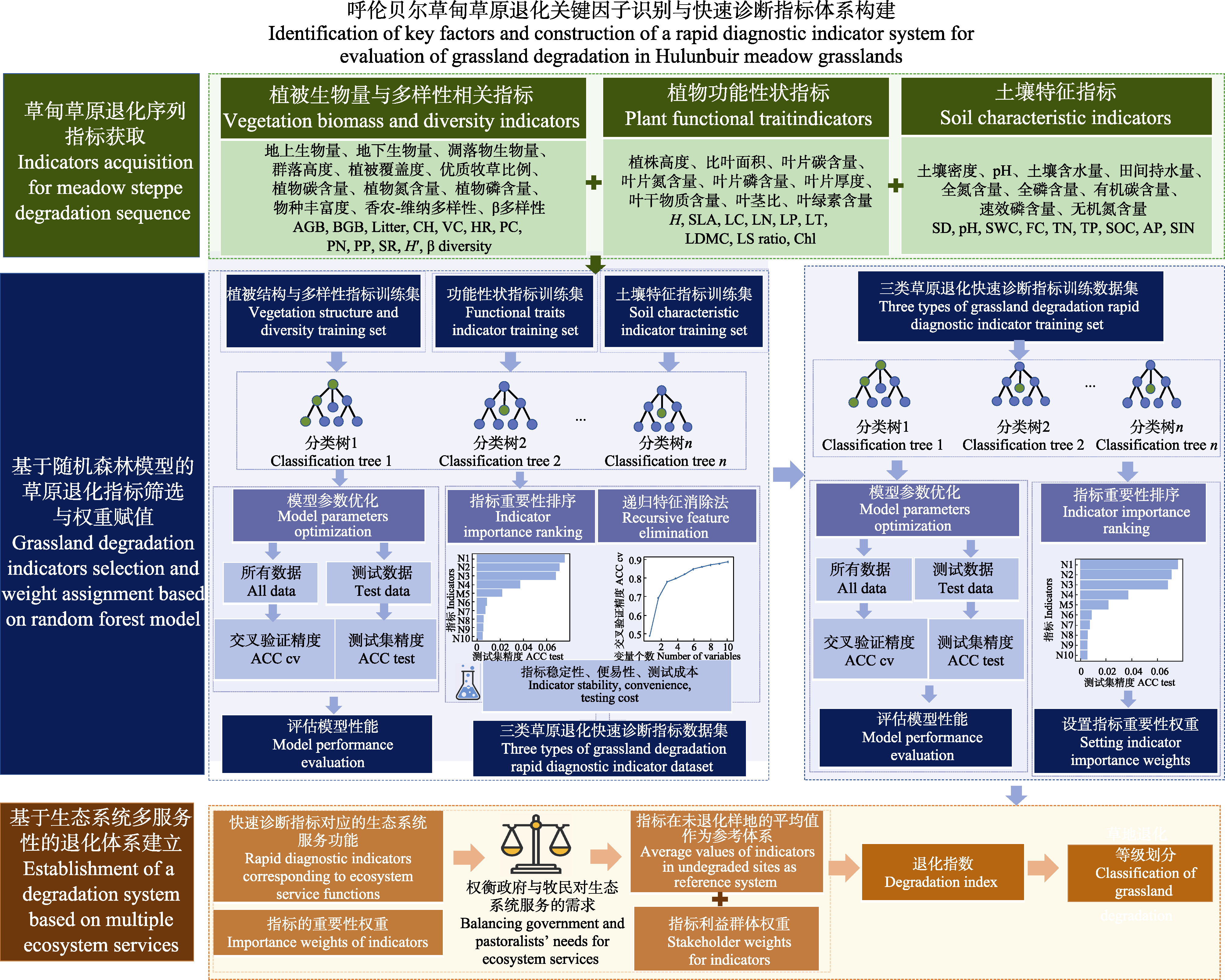
图1 草甸草原退化指标识别与快速诊断指标体系构建流程图。
Fig. 1 Process diagram for identifying degradation indicators and constructing a rapid diagnostic indicator system for meadow steppe degradation. ACC cv, cross-validation accuracy; ACC test, test set accuracy; AGB, aboveground biomass; AP, soil available phosphorus content; BGB, belowground biomass; CH, community height; Chl, chlorophyll content; FC, field water holding capacity; H, height; H′, Shannon-Wiener diversity index; HR, high quality forage ratio; LC, leaf carbon content; LDMC, leaf dry matter content; Litter, litter biomass; LN, leaf nitrogen content; LP, leaf phosphorus content; LS ratio, leaf to stem ratio; LT, leaf thickness; PC, plant community carbon content; PN, plant community nitrogen content; PP, plant community phosphorus content; SD, soil density; SIN, soil inorganic nitrogen content; SR, species richness; SOC, soil organic carbon content; SWC, soil water content; TN, soil total nitrogen content; TP, soil total phosphorus content; VC, vegetation cover.
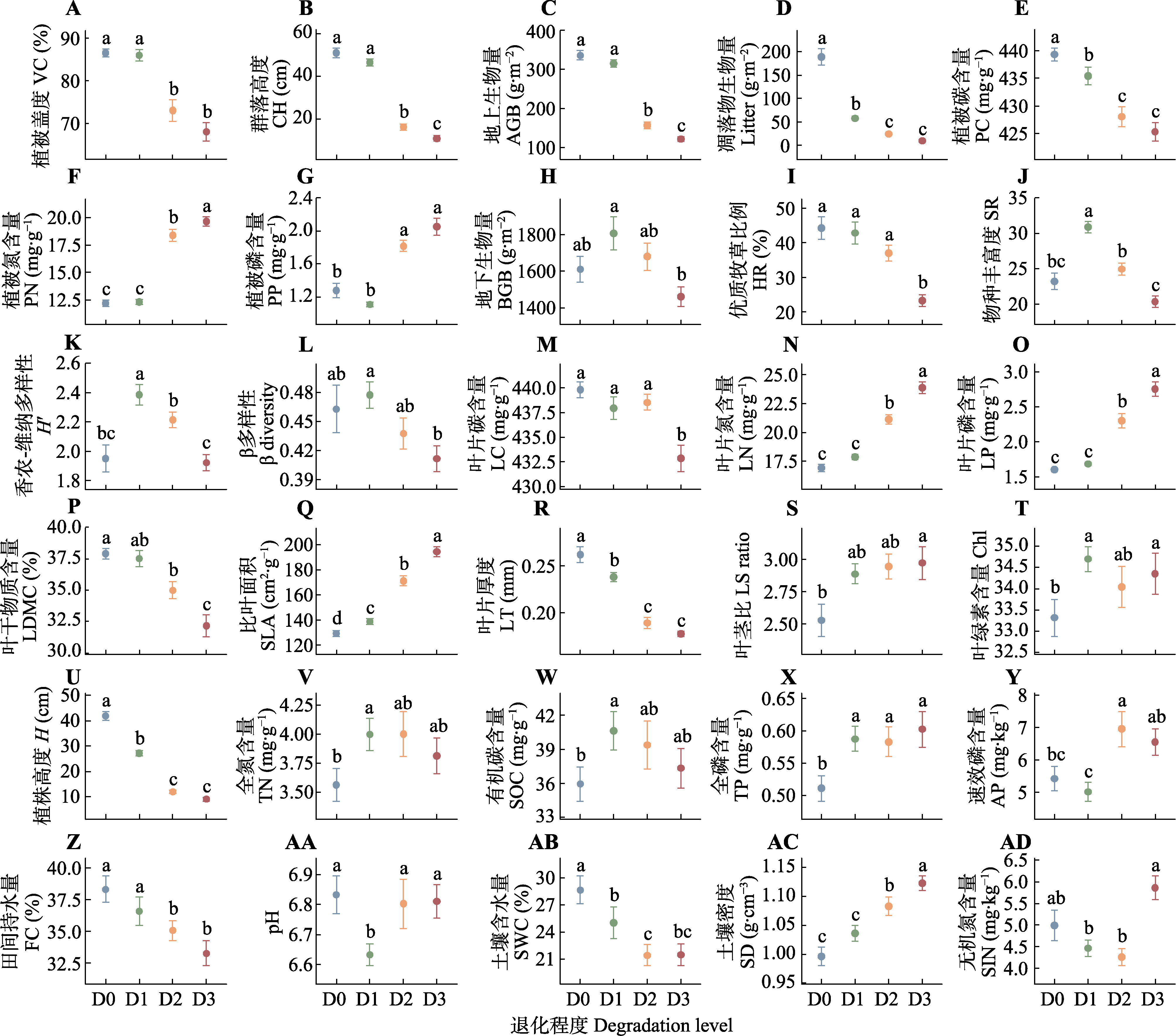
图2 草甸草原不同退化程度下植被与土壤指标的变化(平均值±标准误)。D0, 未退化; D1, 轻度退化; D2, 中度退化; D3, 重度退化。A-L代表植被群落结构与多样性指标; M-U代表植物功能性状指标; V-AD代表土壤特征指标。不同小写字母表示不同退化程度间差异显著(p < 0.05)。
Fig. 2 Changes in vegetation and soil indicators across various degradation levels of meadow steppe (mean ± SE). D0, no degradation; D1, slight degradation; D2, moderate degradation; D3, severe degradation. A-L represent indicators of vegetation community structure and diversity; M-U denote plant functional trait indicators; V-AD indicate soil characteristic indicators. Different lowercase letters indicate significant differences among different degrees of degradation (p < 0.05). AGB, aboveground biomass; AP, soil available phosphorus content; BGB, belowground biomass; CH, community height; Chl, chlorophyll content; FC, field water holding capacity; H, plant height; H′, Shannon-Wiener diversity; HR, high quality forage ratio; LC, leaf carbon content; LDMC, leaf dry matter content; Litter, litter biomass; LN, leaf nitrogen content; LP, leaf phosphorus content; LS ratio, leaf to stem ratio; LT, leaf thickness; PC, plant community carbon content; PN, plant community nitrogen content; PP, plant community phosphorus content; SD, soil density; SIN, soil inorganic nitrogen content; SOC, soil organic carbon content; SR, species richness; SWC, soil water content; TN, soil total nitrogen content; TP, soil total phosphorus content; VC, vegetation cover.
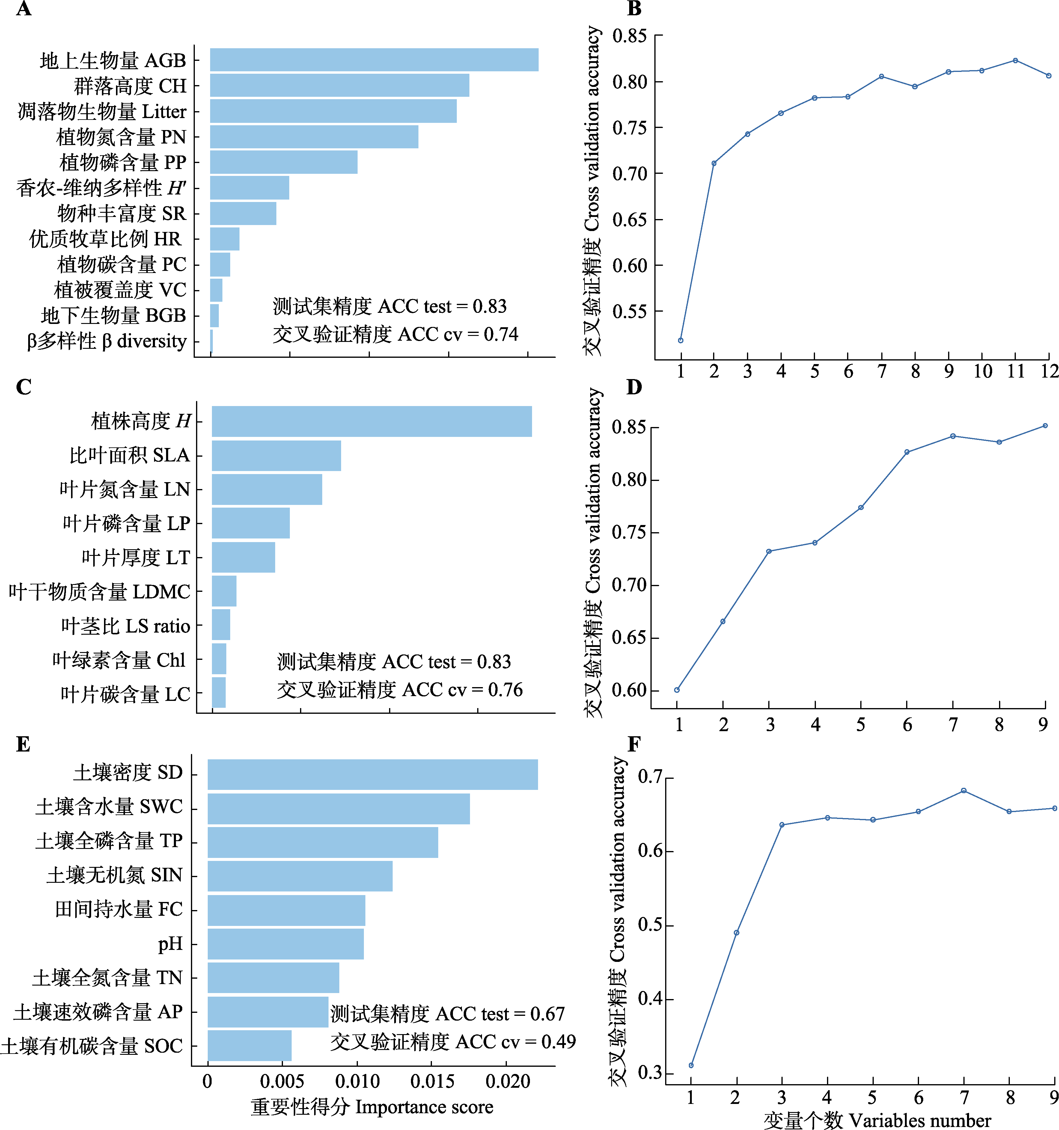
图3 随机森林方法筛选退化指标。A、C、E, 植被结构与多样性指标、植物功能性状指标、土壤指标的重要性排序。B、D、F, 递归式特征消除法筛选植被结构与多样性、植物功能性状、土壤指标的个数。
Fig. 3 Random forest method for screening degradation indicators, A, C, E, Importance ranking of vegetation structure and diversity indicators, plant functional traits, and soil indicators. B, D, F, Recursive feature elimination for selecting numbers of vegetation structure and diversity, plant functional traits, and soil indicators; red dots indicate optimal number of indicator. ACC cv, cross-validation accuracy; ACC test, test set accuracy. AGB, aboveground biomass; AP, soil available phosphorus content; BGB, belowground biomass; CH, community height; Chl, chlorophyll content; FC, field water holding capacity; H, plant height; H′, Shannon-Wiener diversity; HR, high quality forage ratio; LC, leaf carbon content; LDMC, leaf dry matter content; LN, leaf nitrogen content; LP, leaf phosphorus content; LS ratio, leaf to stem ratio; LT, leaf thickness; Litter, litter biomass; PC, plant community carbon content; PN, plant community nitrogen content; PP, plant community phosphorus content; SD, soil density; SIN, soil inorganic nitrogen content; SOC, soil organic carbon content; SR, species richness; SWC, soil water content; TN, soil total nitrogen content; TP, soil total phosphorus content; VC, vegetation cover.
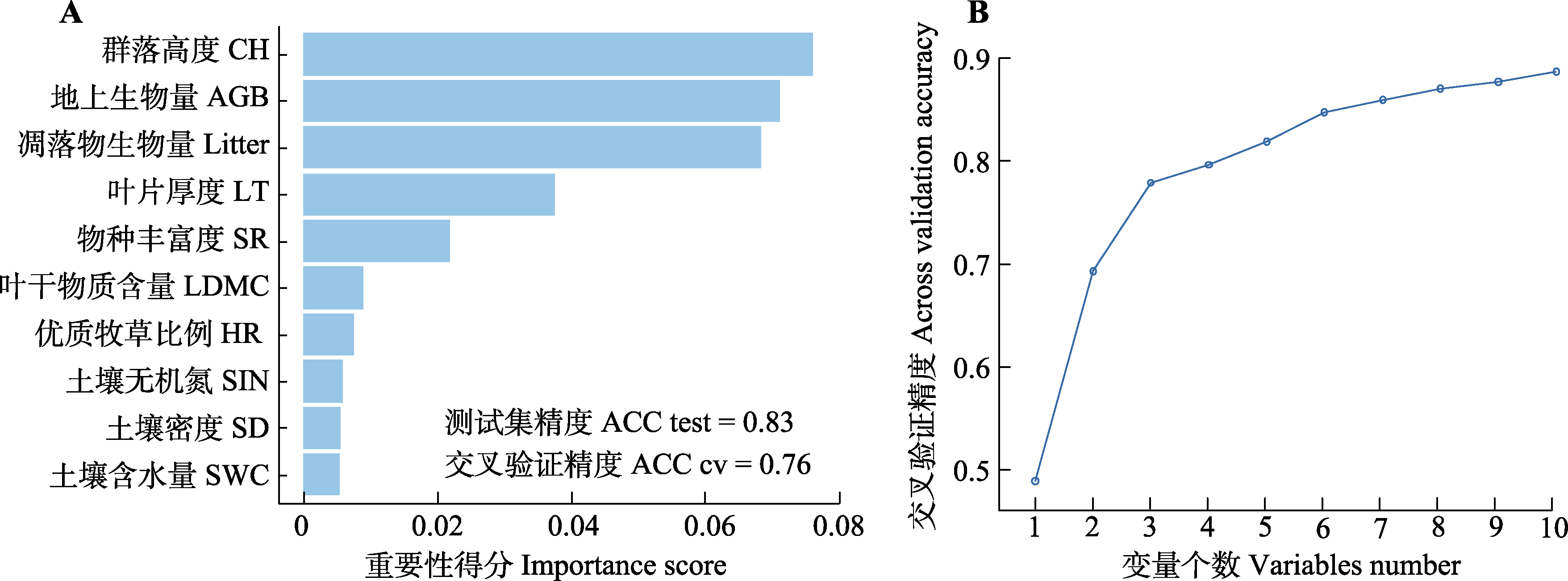
图4 草甸草原退化诊断指标的筛选。A, 随机森林方法对退化指标的重要性排序。B, 递归式特征消除法筛选指标的个数。
Fig. 4 Selection of diagnostic indicators for meadow steppe degradation. A, Importance ranking of degradation indicators by random forest method. B, Number of indicators selected by recursive feature elimination. ACC cv, cross-validation accuracy; ACC test, test set accuracy. AGB, aboveground biomass; CH, community height; HR, high quality forage ratio; LDMC, leaf dry matter content; LT, leaf thickness; Litter, litter biomass; SD, soil density; SIN, soil inorganic nitrogen content; SR, species richness; SWC, soil water content.
| 功能类型 Function type | 生态系统服务 Ecosystem service | 政府 Government | 牧民 Herdsman | 平均 Average |
|---|---|---|---|---|
| 调节 Regulating | 侵蚀控制 Erosion control | 0.35 | 0.05 | 0.20 |
| 水分养分调节 Water and nutrient regulation | 0.15 | 0.05 | 0.10 | |
| 供给 Provisioning | 牧草供应 Forage supply | 0.20 | 0.60 | 0.40 |
| 支持 Supporting | 多样性保护 Diversity protection | 0.20 | 0.10 | 0.15 |
| 植被抗逆 Vegetation resilience | 0.10 | 0.20 | 0.15 |
表4 不同利益群体(政府与牧民)对草原生态系统服务功能的需求差异与权重赋值
Table 4 Differences in demand and weight assignment for grassland ecosystem services between stakeholder groups (government and herders)
| 功能类型 Function type | 生态系统服务 Ecosystem service | 政府 Government | 牧民 Herdsman | 平均 Average |
|---|---|---|---|---|
| 调节 Regulating | 侵蚀控制 Erosion control | 0.35 | 0.05 | 0.20 |
| 水分养分调节 Water and nutrient regulation | 0.15 | 0.05 | 0.10 | |
| 供给 Provisioning | 牧草供应 Forage supply | 0.20 | 0.60 | 0.40 |
| 支持 Supporting | 多样性保护 Diversity protection | 0.20 | 0.10 | 0.15 |
| 植被抗逆 Vegetation resilience | 0.10 | 0.20 | 0.15 |
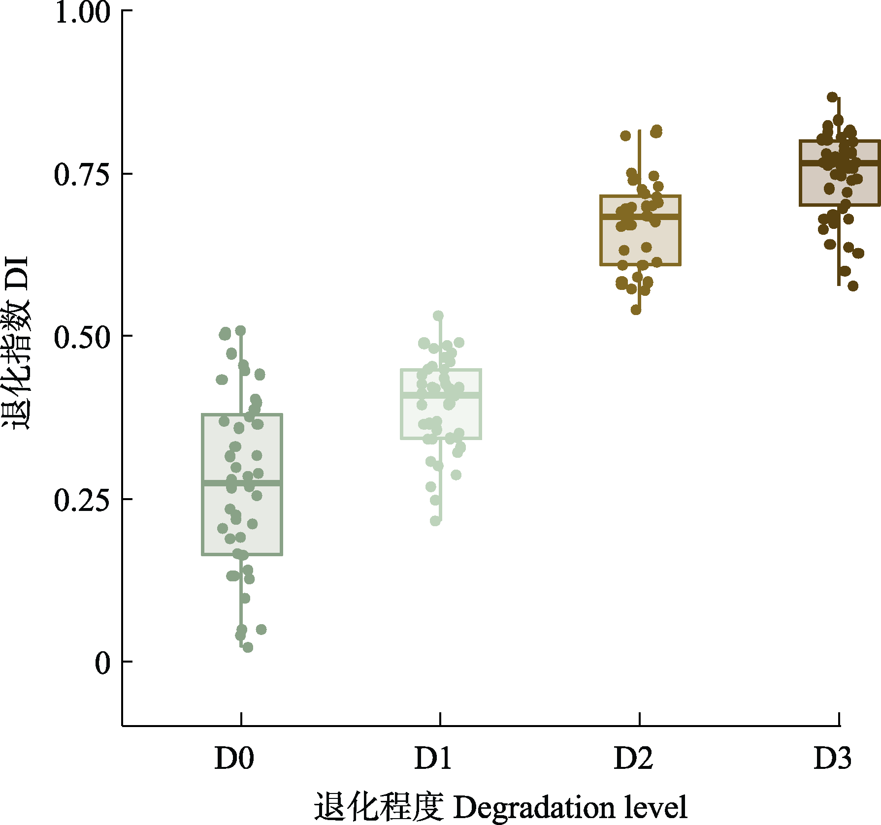
图5 研究区域中不同退化等级样地的退化指数(DI)。D0, 未退化; D1, 轻度退化; D2, 中度退化; D3, 重度退化。
Fig. 5 Degradation index (DI) of sample plots at different degradation levels in the study area. D0, no degradation; D1, slight degradation; D2, moderate degradation; D3, severe degradation.
| 草甸草原退化等级 Degradation levels of meadow steppe | 未退化 No degradation | 轻度退化 Light degradation | 中度退化 Moderate degradation | 重度退化 Heavy degradation |
|---|---|---|---|---|
| 指数范围 Index range | DI ≤ 0.35 | 0.35 < DI ≤ 0.55 | 0.55 < DI ≤ 0.75 | DI > 0.75 |
表5 草甸草原退化评估指标等级划分
Table 5 Grading of degradation assessment indicators in meadow grasslands
| 草甸草原退化等级 Degradation levels of meadow steppe | 未退化 No degradation | 轻度退化 Light degradation | 中度退化 Moderate degradation | 重度退化 Heavy degradation |
|---|---|---|---|---|
| 指数范围 Index range | DI ≤ 0.35 | 0.35 < DI ≤ 0.55 | 0.55 < DI ≤ 0.75 | DI > 0.75 |
| [1] |
Allan E, Manning P, Alt F, Binkenstein J, Blaser S, Blüthgen N, Böhm S, Grassein F, Hölzel N, Klaus VH, Kleine-becker T, Morris EK, Oelmann Y, Prati D, Renner SC, et al. (2015). Land use intensification alters ecosystem multifunctionality via loss of biodiversity and changes to functional composition. Ecology Letters, 18, 834-843.
DOI PMID |
| [2] | Bai Y, Wu J, Clark C, Pan Q, Zhang L, Chen S, Wang Q, Han X (2012). Grazing alters ecosystem functioning and C:N:P stoichiometry of grasslands along a regional precipitation gradient. Journal of Applied Ecology, 49, 1204-1215. |
| [3] | Bardgett RD, Bullock JM, Lavorel S, Manning P, Schaffner U, Ostle N, Chomel M, Durigan G, Fry EL, Johnson D, Lavallee JM, Le Provost G, Luo S, Png K, Sankaran M, et al. (2021). Combatting global grassland degradation. Nature Reviews Earth & Environment, 2, 720-735. |
| [4] | Bengtsson J, Bullock JM, Egoh B, Everson C, Everson T, O’Connor T, O’Farrell PJ, Smith HG, Lindborg R (2019). Grasslands—More important for ecosystem services than you might think. Ecosphere, 10, e02582. DOI: 10.1002/ecs2.2582. |
| [5] | Bezzano M (2018). UK natural capital: developing semi-natural grassland ecosystem accounts.[2024-05-06]. https://www.ons.gov.uk/economy/environmentalaccounts/methodologies/uknaturalcapitaldevelopingseminaturalgrasslandecosystemaccounts. |
| [6] | Breiman L (2001). Random forests. Machine Learning, 45, 5-32. |
| [7] | Chao A, Chiu CH, Jost L (2014). Unifying species diversity, phylogenetic diversity, functional diversity, and related similarity and differentiation measures through hill numbers. Annual Review of Ecology, Evolution and Systematics, 45, 297-324. |
| [8] | Chen SS, Wang M, Zhang C, Xin XP, Zhu XY, Guo LF, Yan RR (2023). Effects of different grazing intensities on soil active organic carbon in Leymus chinensis meadow steppe in Hulunbuir. Soil and Fertilizer Sciences in China, (11), 16-24. |
| [陈思思, 王淼, 张楚, 辛晓平, 朱晓昱, 郭雷风, 闫瑞瑞 (2023). 不同放牧强度对呼伦贝尔羊草草甸草原土壤活性有机碳的影响. 中国土壤与肥料, (11), 16-24.] | |
| [9] | Chen Y, Wang W, Guan Y, Liu FZ, Zhang YB, Du JH, Feng CT, Zhou Y (2020). An integrated approach for risk assessment of rangeland degradation: a case study in Burqin County, Xinjiang, China. Ecological Indicators, 113, 106203. DOI: 10.1016/j.ecolind.2020.106203. |
| [10] | Cornelissen JHC, Lavorel S, Garnier E, Díaz S, Buchmann N, Gurvich DE, Reich PB ter Steege H, Morgan HD, van der Heijden MGA, Pausas JG, Poorter H (2003). A handbook of protocols for standardised and easy measurement of plant functional traits worldwide. Australian Journal of Botany, 51, 335-380. |
| [11] | Díaz S, Noy-Meir I, Cabido M (2001). Can grazing response of herbaceous plants be predicted from simple vegetative traits? Journal of Applied Ecology, 38, 497-508. |
| [12] | Díaz S, Settele J, Brondízio ES, Ngo HT, Agard J, Arneth A, Balvanera P, Brauman KA, Butchart SHM, Chan KMA, Garibaldi LA, Ichii K, Liu J, Subramanian SM, Midgley GF, et al. (2019). Pervasive human-driven decline of life on Earth points to the need for transformative change. Science, 366, eaax3100. DOI: 10.1126/science.aax3100. |
| [13] | Dong SK, Zhang YH, Wang GC (2023). Assessment of grassland health and degradation: concepts, principles, and methods. Pratacultural Science, 40, 2971-2981. |
| [董世魁, 张宇豪, 王冠聪 (2023). 草地健康与退化评价: 概念、原理及方法. 草业科学, 40, 2971-2981.] | |
| [14] | Du XJ, Gao XM, Ma KP (2003). Diagnosis of the degree of degradation of an ecosystem: the basis and precondition of ecological restoration. Acta Phytoecologica Sinica, 27, 700-708. |
|
[杜晓军, 高贤明, 马克平 (2003). 生态系统退化程度诊断: 生态恢复的基础与前提. 植物生态学报, 27, 700-708.]
DOI |
|
| [15] | Du ZY, Cai YJ, Wang XD, Zhang B (2019). Research progress on yak grazing behavior and its influence on the soil properties of alpine grassland. Acta Prataculturae Sinica, 28(7), 186-197. |
|
[杜子银, 蔡延江, 王小丹, 张斌 (2019). 放牧牦牛行为及其对高寒草地土壤特性的影响研究进展. 草业学报, 28(7), 186-197.]
DOI |
|
| [16] | Du ZY, Cong N (2024). Responses of vegetation and soil characteristics to degraded grassland under different degrees on the Qinghai-Tibet Plateau. Acta Ecologica Sinica, 44, 2504-2516. |
| [杜志勇, 丛楠 (2024). 植被与土壤特征对青藏高原不同程度退化草地的响应. 生态学报, 44, 2504-2516.] | |
| [17] |
Eldridge DJ, Ding J, Dorrough J, Delgado-Baquerizo M, Sala O, Gross N, Le Bagousse-Pinguet Y, Mallen-Cooper M, Saiz H, Asensio S, Ochoa V, Gozalo B, Guirado E, García-Gómez M, Valencia E, et al. (2024). Hotspots of biogeochemical activity linked to aridity and plant traits across global drylands. Nature Plants, 10, 760-770.
DOI PMID |
| [18] | Gao J, Carmel Y (2020). A global meta-analysis of grazing effects on plant richness. Agriculture, Ecosystems & Environment, 302, 107072. DOI: 10.1016/j.agee.2020.107072. |
| [19] | Garnier E, Cortez J, Billès G, Navas ML, Roumet C, Debussche M, Laurent G, Blanchard A, Aubry D, Bellmann A, Neill C, Toussaint JP (2004). Plant functional markers capture ecosystem properties during secondary succession. Ecology, 85, 2630-2637. |
| [20] | General Administration of Quality Supervision, Inspection and Quarantine of the People’s Republic of China (2003). Grading indicators for natural grassland degradation, desertification, and salinization (GB 19377-2003).[2024-05-06]. https://std.samr.gov.cn/gb/search/gbDetailed?id=71F772D77C23D3A7E05397BE0A0AB82A |
| [中华人民共和国国家质量监督检验检疫总局 (2003). 天然草地退化、沙化、盐渍化的分级指标(GB 19377-2003).[2024-05-06]. https://std.samr.gov.cn/gb/search/gbDetailed?id=71F772D77C23D3A7E05397BE0A0AB82A.] | |
| [21] | Gislason PO, Benediktsson JA, Sveinsson JR (2006). Random Forests for land cover classification. Pattern Recognition Letters, 27, 294-300. |
| [22] | Gretton P, Salma U (1996). Land degradation and the Australian agricultural industry.[2024-05-06]. https://www.pc.gov.au/research/supporting/land-degradation. |
| [23] | Guyon I, Weston J, Barnhill S, Vapnik V (2002). Gene selection for cancer classification using support vector machines. Machine Learning, 46, 389-422. |
| [24] | Håkansson I, Lipiec J (2000). A review of the usefulness of relative bulk density values in studies of soil structure and compaction. Soil and Tillage Research, 53, 71-85. |
| [25] | Havstad KM, Peters DPC, Skaggs R, Brown J, Bestelmeyer B, Fredrickson E, Herrick J, Wright J (2007). Ecological services to and from rangelands of the United States. Ecological Economics, 64, 261-268. |
| [26] | Hou LL, Yan RR, Zhang Y, Xin XP (2020). Effects of grazing intensity on the functional traits of Leymus chinensis in meadow steppe. Scientia Agricultura Sinica, 53, 2562-2572. |
|
[侯路路, 闫瑞瑞, 张宇, 辛晓平 (2020). 放牧强度对草甸草原羊草功能性状的影响. 中国农业科学, 53, 2562-2572.]
DOI |
|
| [27] | Huang L, Fan JW, Yang Z, Wang GC, Li YZ, Zhang HY, Zhang YX, Shi JH, Wang SZ (2024). All-in-one assessment of grassland health, degradation, and restoration: the concepts and methods. Chinese Science Bulletin, 15, 2015-2024. |
| [黄麟, 樊江文, 杨智, 王冠聪, 李愈哲, 张海燕, 张雅娴, 石俊华, 王穗子 (2024). 草原健康、退化与恢复一体化评估: 概念与方法. 科学通报, 15, 2015-2024.] | |
| [28] | Inner Mongolia Autonomous Region Market Supervision and Management Bureau (2021). Degradation grading indicators for grasslands (DB15/T 2384-2021).[2024-05-06]. https://std.samr.gov.cn/db/search/stdDBDetailed?id=CE22979AC9AE3A22E05397BE0A0A76AB. |
| [内蒙古自治区市场监督管理局 (2021). 草原退化分级指标 (DB15/T 2384-2021).[2024-05-06]. https://std.samr.gov.cn/db/search/stdDBDetailed?id=CE22979AC9AE3A22E05397BE0A0A76AB.] | |
| [29] | Inner Mongolia Livestock Department (1999). Inner Mongolia local standards for natural grassland degradation. Inner Mongolia Grass Industry, 11, 62-63. |
| [内蒙古自治区畜牧厅 (1999). 内蒙古自治区地方标准: 内蒙古天然草地退化标准. 内蒙古草业, 11, 62-63.] | |
| [30] | Jiang XL, Zhang WG (2010). Functional diversity and its research method. Acta Ecologica Sinica, 30, 2766-2773. |
| [江小雷, 张卫国 (2010). 功能多样性及其研究方法. 生态学报, 30, 2766-2773.] | |
| [31] | Jiang ZY, Hu ZM, Lai DYF, Han DR, Wang M, Liu M, Zhang M, Guo MY (2020). Light grazing facilitates carbon accumulation in subsoil in Chinese grasslands: a meta-analysis. Global Change Biology, 26, 7186-7197. |
| [32] |
Jing X, He JS (2021). Relationship between biodiversity, ecosystem multifunctionality and multiserviceability: literature overview and research advances. Chinese Journal of Plant Ecology, 45, 1094-1111.
DOI |
|
[井新, 贺金生 (2021). 生物多样性与生态系统多功能性和多服务性的关系: 回顾与展望. 植物生态学报, 45, 1094-1111.]
DOI |
|
| [33] | Kuang WH, Yan HM, Zhang SW, Li XY, Bao ZY, Ning J, Zhang PA, Fan B, Wang SS (2018). Forage-livestock status in farms and ranches of ecological grass-animal husbandry construction and allocation model of grain-warp-feed in Hulunbuir Agricultural Reclamation Group. Chinese Science Bulletin, 63, 1711-1721. |
| [匡文慧, 闫慧敏, 张树文, 李孝永, 包正义, 宁静, 张平安, 范冰, 王珊珊 (2018). 呼伦贝尔农垦集团草畜平衡状况与粮经饲配置模式. 科学通报, 63, 1711-1721.] | |
| [34] | Li B (1997). Degradation of grasslands in northern China and its prevention strategies. Chinese Journal of Agricultural Science, 6, 2-10. |
| [李博 (1997). 中国北方草地退化及其防治对策. 中国农业科学, 6, 2-10.] | |
| [35] | Li B, Sun HL, Zeng SD, Pu HX (1980). Discussion on grassland vegetation resources and their utilization direction in Hulunbeier pastoral area. Natural Resources, 2, 30-36. |
| [李博, 孙鸿良, 曾泗弟, 浦汉昕 (1980). 呼伦贝尔牧区草场植被资源及其利用方向的探讨. 自然资源, 2, 30-36.] | |
| [36] | Li FX, Zhang DG (2005). Indicators and recovery approaches of degenerated grassland in China. Grassland and Turf, 1, 24-28. |
| [李凤霞, 张德罡 (2005). 草地退化指标及恢复措施. 草原与草坪, 1, 24-28.] | |
| [37] | Li J, Wurenqiqige, Huang ZY (2013). Analysis on characteristic of plant community species composition under different degeneration degree grassland in the meadow steppe of Hulunbuir. Guangdong Agricultural Sciences, 40, 139-143. |
| [李杰, 乌仁其其格, 黄振艳 (2013). 呼伦贝尔草甸草原不同退化程度草地群落物种组成特征分析. 广东农业科学, 40, 139-143.] | |
| [38] | Liu B, You GY, Li R, Shen WS, Yue YM, Lin NF (2015). Spectral characteristics of alpine grassland and their changes responding to grassland degradation on the Tibetan Plateau. Environmental Earth Sciences, 74, 2115-2123. |
| [39] |
Liu ZL, Wang W, Liang CZ, Hao DY (1998). The regressive succession pattern and its diagnostic of Inner Mongolia steppe in sustained and superstrong grazing. Acta Agrestia Sinica, 6, 244-251.
DOI |
|
[刘钟龄, 王炜, 梁存柱, 郝敦元 (1998). 内蒙古草原植被在持续牧压下退化演替的模式与诊断. 草地学报, 6, 244-251.]
DOI |
|
| [40] | Lyu X, Li XB, Dang DL, Dou HS, Wang K, Gong JR, Wang H, Liu SL (2022). A perspective on the impact of grassland degradation on ecosystem services for the purpose of sustainable management. Remote Sensing, 14, 5120. DOI: 10.3390/rs14205120. |
| [41] | Manning P, van der Plas F, Soliveres S, Allan E, Maestre FT, Mace G, Whittingham MJ, Fischer M (2018). Redefining ecosystem multifunctionality. Nature Ecology & Evolution, 2, 427-436. |
| [42] | Meng TT, Ni J, Wang GH (2007). Plant functional traits, environments and ecosystem functioning. Journal of Plant Ecology (Chinese Version), 31, 150-165. |
|
[孟婷婷, 倪健, 王国宏 (2007). 植物功能性状与环境和生态系统功能. 植物生态学报, 31, 150-165.]
DOI |
|
| [43] | Miao L, Sun Z, Ren Y, Schierhorn F, Müller D (2021). Grassland greening on the Mongolian Plateau despite higher grazing intensity. Land Degradation & Development, 32, 792-802. |
| [44] | Milchunas DG, Lauenroth WK (1993). Quantitative effects of grazing on vegetation and soils over a global range of environments. Ecological Monographs, 63, 327-366. |
| [45] | Niu K, He J, Lechowicz MJ (2016). Grazing-induced shifts in community functional composition and soil nutrient availability in Tibetan alpine meadows. Journal of Applied Ecology, 53, 1554-1564. |
| [46] | Oksanen J, Simpson GL, Blanchet FG, Kindt R, Legendre P, Minchin PR, O’Hara RB, Solymos P, Stevens MHH, Szoecs E, Wagner H, Barbour M, Bedward M, Bolker B, Borcard D, et al. (2024). Vegan: community ecology package.[2024-05-21]. https://CRAN.R-project.org/package=vegan. |
| [47] | Pan QM, Yang YH, Huang JH (2023). Limiting factors of degraded grassland restoration in China and related basic scientific issues. Bulletin of National Natural Science Foundation of China, 37, 571-579. |
| [潘庆民, 杨元合, 黄建辉 (2023). 我国退化草原恢复的限制因子及需要解决的基础科学问题. 中国科学基金, 37, 571-579.] | |
| [48] |
Quétier F, Lavorel S, Thuiller W, Davies I (2007). Plant-trait-based modeling assessment of ecosystem- service sensitivity to land-use change. Ecological Applications, 17, 2377-2386.
PMID |
| [49] | Ren HY, Zheng SX, Bai YF (2009). Effects of grazing on foliage biomass allocation of grassland communities in Xilin river basin, Inner Mongolia. Chinese Journal of Plant Ecology, 33, 1065-1074. |
|
[任海彦, 郑淑霞, 白永飞 (2009). 放牧对内蒙古锡林河流域草地群落植物茎叶生物量资源分配的影响. 植物生态学报, 33, 1065-1074.]
DOI |
|
| [50] | Shi Y, Ma YL, Ma WH, Liang CZ, Zhao XQ, Fang JY, He JS (2013). Large scale patterns of forage yield and quality across Chinese grasslands. Chinese Science Bulletin, 58, 226-239. |
| [石岳, 马殷雷, 马文红, 梁存柱, 赵新全, 方精云, 贺金生 (2013). 中国草地的产草量和牧草品质: 格局及其与环境因子之间的关系. 科学通报, 58, 226-239.] | |
| [51] |
Smith P, House JI, Bustamante M, Sobocká J, Harper R, Pan GX, West PC, Clark JM, Adhya T, Rumpel C, Paustian K, Kuikman P, Cotrufo MF, Elliott JA, McDowell R, et al. (2016). Global change pressures on soils from land use and management. Global Change Biology, 22, 1008-1028.
DOI PMID |
| [52] |
Stosch KC, Quilliam RS, Bunnefeld N, Oliver DM (2019). Quantifying stakeholder understanding of an ecosystem service trade-off. Science of the Total Environment, 651, 2524-2534.
DOI |
| [53] | Su TT, Ma HB, Zhou Y, Jia XY, Zhang R, Zhang SQ, Hu YL (2019). Response of typical steppe grassland soil physical and chemical properties to various ecological restoration measures in the Ningxia Loess Hill Region. Acta Prataculturae Sinica, 28(4), 34-46. |
|
[宿婷婷, 马红彬, 周瑶, 贾希洋, 张蕊, 张双乔, 胡艳莉 (2019). 黄土丘陵典型草原土壤理化性质对生态恢复措施的响应. 草业学报, 28(4), 34-46.]
DOI |
|
| [54] | Tian D, Xiang Y, Seabloom E, Chen HYH, Wang J, Yu G, Deng Y, Li Z, Niu S (2022). Ecosystem restoration and belowground multifunctionality: a network view. Ecological Applications, 32, e2575. DOI: 10.1002/eap.2575. |
| [55] | USDA US Department of Agriculture (2022). National Range and Pasture Handbook. [2024-05-06]. https://directives.sc.egov.usda.gov/landingpage/34155. |
| [56] | Wang M (2022). Effects of Different Grazing Intensities on Carbon, Nitrogen and Phosphorus Stoichiometric Characteristics and Stocks of Meadow Steppe Ecosystems. Master degree dissertation, Chinese Academy of Agricultural Sciences, Beijing. 30-31. |
| [王淼 (2022). 不同放牧强度对草甸草原生态系统碳氮磷化学计量特征及储量影响. 硕士学位论文, 中国农业科学院, 北京. 30-31.] | |
| [57] | Wang XF, Ma HB, Liu J, Miao HT, Shen Y, Zhou Y, Ma JL (2022). Research advances on the effects of grazing on plant functional traits in grassland. Chinese Journal of Applied Ecology, 33, 569-576. |
|
[王晓芳, 马红彬, 刘杰, 苗海涛, 沈艳, 周瑶, 马静利 (2022). 放牧对草原植物功能性状影响研究进展. 应用生态学报, 33, 569-576.]
DOI |
|
| [58] | Wang XT, Zhang SH, Chen DD, Tan YR, Sun DS, Du GZ (2010). The effects of natural grazing intensity on plant community and soil nutrients in alpine meadow. Acta Agrestia Sinica, 18, 510-516. |
|
[王向涛, 张世虎, 陈懂懂, 谈嫣蓉, 孙大帅, 杜国祯 (2010). 不同放牧强度下高寒草甸植被特征和土壤养分变化研究. 草地学报, 18, 510-516.]
DOI |
|
| [59] | Wright IJ, Reich PB, Westoby M, Ackerly DD, Baruch Z, Bongers F, Cavender-Bares J, Chapin T, Cornelissen JHC, Diemer M, Flexas J, Garnier E, Groom PK, Gulias J, Hikosaka K, et al. (2004). The worldwide leaf economics spectrum. Nature, 428, 821-827. |
| [60] | Wurenqigege (2009). Studys of the Characteristic of Vegetation and Soil and Indication Under the Different Degeneration Degree in the Meadow Steppe. PhD dissertation, Inner Mongolia Agricultural University, Hohhot. 12-13. |
| [乌仁其其格 (2009). 草甸草原不同退化程度下植被与土壤特征与指示度研究. 博士学位论文, 内蒙古农业大学, 呼和浩特. 12-13.] | |
| [61] | Wuyunga, Wulantuya, Zhang WQ, Siqinchaoketu, Gaosuriguga, Bao MS (2023). Analysis of the evolution of the grassland degradation evaluation index system in China based on CiteSpace. Chinese Journal of Grassland, 45(5), 125-136. |
| [乌云嘎, 乌兰图雅, 张卫青, 斯琴朝克图, 高苏日固嘎, 包木苏 (2023). 基于CiteSpace的中国草地退化评价指标体系演进分析. 中国草地学报, 45(5), 125-136.] | |
| [62] | Xiong DP, Shi PL, Zhang XZ, Zou CB (2016). Effects of grazing exclusion on carbon sequestration and plant diversity in grasslands of China—A meta-analysis. Ecological Engineering, 94, 647-655. |
| [63] | Xu DW (2019). Distribution Change and Analysis of Different Grassland Types in Hulunber Grassland. PhD dissertation, Chinese Academy of Agricultural Sciences, Beijing. 41-42. |
| [徐大伟 (2019). 呼伦贝尔草原区不同草地类型分布变化及分析. 博士学位论文, 中国农业科学院, 北京. 41-42.] | |
| [64] | Xue CF, Zhang W (2009). The dynamic variation of grassland vegetation degeneration based on remote sensing MODIS data. Remote Sensing for Land & Resources, 21, 97-101. |
| [薛存芳, 张玮 (2009). 基于MODIS数据的内蒙古草地植被退化动态监测研究. 国土资源遥感, 21, 97-101.] | |
| [65] | Yan H, Ran QW, Hu RH, Xue K, Zhang B, Zhou ST, Zhang ZP, Tang L, Che RX, Pang Z, Wang F, Wang D, Zhang J, Jiang LL, Qian Z, et al. (2022). Machine learning-based prediction for grassland degradation using geographic, meteorological, plant and microbial data. Ecological Indicators, 137, 108738. DOI: 10.1016/j.ecolind.2022.108738. |
| [66] |
Yan RR, Gao W, Shen BB, Zhang Y, Wang M, Zhu XY, Xin XP (2021). Index system for quantitative evaluation of pasture degradation in meadow grassland of Inner Mongolia. Scientia Agricultura Sinica, 54, 3343-3354.
DOI |
|
[闫瑞瑞, 高娃, 沈贝贝, 张宇, 王淼, 朱晓昱, 辛晓平 (2021). 草甸草原放牧场退化定量评估指标体系建立. 中国农业科学, 54, 3343-3354.]
DOI |
|
| [67] | Yan RR, Xin XP, Wang X, Yan YC, Deng Y, Yang GX (2014). The change of soil carbon and nitrogen under different grazing gradients in Hulunber meadow steppe. Acta Ecologica Sinica, 34, 1587-1595. |
| [闫瑞瑞, 辛晓平, 王旭, 闫玉春, 邓钰, 杨桂霞 (2014). 不同放牧梯度下呼伦贝尔草甸草原土壤碳氮变化及固碳效应. 生态学报, 34, 1587-1595.] | |
| [68] | Yan YC, Tang HP (2008). Differentiation of related concepts of grassland degradation. Acta Prataculturae Sinica, 17(1), 93-99. |
| [闫玉春, 唐海萍 (2008). 草地退化相关概念辨析. 草业学报, 17(1), 93-99.] | |
| [69] | Yan YC, Tang HP, Zhang XS (2007). Diagnosis of grassland degradation degree and its perspectives. Chinese Journal of Grassland, 29(3), 90-97. |
| [闫玉春, 唐海萍, 张新时 (2007). 草地退化程度诊断系列问题探讨及研究展望. 中国草地学报, 29(3), 90-97.] | |
| [70] | Zhang LL, Wang XA, Zhu ZH, Li YN (2018). The effects of simulated grazing intensity and fertilizing on the community characteristics and diversity in alpine meadow of Qinghai-Tibet Plateau. Ecology and Environmental Sciences, 27, 406-415. |
|
[张璐璐, 王孝安, 朱志红, 李英年 (2018). 模拟放牧强度与施肥对青藏高原高寒草甸群落特征和物种多样性的影响. 生态环境学报, 27, 406-415.]
DOI |
|
| [71] | Zhang M, Li XB, Wang H, Huang Q (2018). Comprehensive analysis of grazing intensity impacts soil organic carbon: a case study in typical steppe of Inner Mongolia, China. Applied Soil Ecology, 129, 1-12. |
| [72] | Zhang M, Delgado-Baquerizo M, Li G, Isbell F, Wang Y, Hautier Y, Wang Y, Xiao Y, Cai J, Pan X, Wang L (2023). Experimental impacts of grazing on grassland biodiversity and function are explained by aridity. Nature Communications, 14, 5040. DOI: 10.1038/s41467-023-40809-6. |
| [73] | Zhang YJ, Zhu JT, Shen RN, Wang L (2020). Research progress on the effects of grazing on grassland ecosystem. Chinese Journal of Plant Ecology, 44, 553-564. |
|
[张扬建, 朱军涛, 沈若楠, 王荔 (2020). 放牧对草地生态系统影响的研究进展. 植物生态学报, 44, 553-564.]
DOI |
|
| [74] | Zhao TQ, Ouyang ZY, Jia LQ, Zheng H (2004). Ecosystem services and their valuation of China grassland. Acta Ecologica Sinica, 24, 1101-1110. |
| [赵同谦, 欧阳志云, 贾良清, 郑华 (2004). 中国草地生态系统服务功能间接价值评价. 生态学报, 24, 1101-1110.] | |
| [75] | Zhao YF, Zhu WW, Wei PP, Fang P, Zhang XW, Yan NN, Liu WJ, Zhao H, Wu QR (2022). Classification of Zambian grasslands using random forest feature importance selection during the optimal phenological period. Ecological Indicators, 135, 108529. DOI: 10.1016/j.ecolind.2021.108529. |
| [76] | Zheng JH, Zhang B, Zhang F, Zhao TQ, Wang Q, Han GD, Zhao ML (2023). Effects of fencing on near-term ecosystem multifunctionality in a typical steppe in Inner Mongolia. Agriculture, Ecosystems & Environment, 342, 108238. DOI: 10.1016/j.agee.2022.108238. |
| [77] | Zhou G, Zhou X, He Y, Shao J, Hu Z, Liu R, Zhou H, Hosseinibai S (2017a). Grazing intensity significantly affects belowground carbon and nitrogen cycling in grassland ecosystems: a meta-analysis. Global Change Biology, 23, 1167-1179. |
| [78] | Zhou W, Yang H, Huang L, Chen C, Lin XS, Hu ZJ, Li JL (2017b). Grassland degradation remote sensing monitoring and driving factors quantitative assessment in China from 1982 to 2010. Ecological Indicators, 83, 303-313. |
| [1] | 牛亚平, 高晓霞, 姚世庭, 杨元合, 彭云峰. 退化高寒草地植物多样性和功能群组成与地上生产力的关系[J]. 植物生态学报, 2025, 49(1): 83-92. |
| [2] | 李天琦, 曹继容, 柳小妮, 田思惠, 兰波兰, 邱颖, 薛建国, 张倩, 褚建民, 张淑敏, 黄建辉, 李凌浩, 王其兵. 内蒙古典型草原土壤酶化学计量与限制性养分对放牧的响应[J]. 植物生态学报, 2025, 49(1): 19-29. |
| [3] | 房凯, 王迎新, 黄建辉, 段俊光, 张琦, 张倩, 甘红豪, 褚建民. 内蒙古典型草原不同退化阶段植被恢复的养分限制因子解析[J]. 植物生态学报, 2025, 49(1): 7-18. |
| [4] | 吴赞, 彭云峰, 杨贵彪, 李秦鲁, 刘洋, 马黎华, 杨元合, 蒋先军. 青藏高原高寒草地退化对土壤及微生物化学计量特征的影响[J]. 植物生态学报, 2022, 46(4): 461-472. |
| [5] | 薛鹏飞, 李文龙, 朱高峰, 周华坤, 刘陈立, 晏和飘. 黄河首曲玛曲县高寒湿地景观格局演变[J]. 植物生态学报, 2021, 45(5): 467-475. |
| [6] | 潘权, 郑华, 王志恒, 文志, 杨延征. 植物功能性状对生态系统服务影响研究进展[J]. 植物生态学报, 2021, 45(10): 1140-1153. |
| [7] | 井新, 贺金生. 生物多样性与生态系统多功能性和多服务性的关系: 回顾与展望[J]. 植物生态学报, 2021, 45(10): 1094-1111. |
| [8] | 汤永康, 武艳涛, 武魁, 郭之伟, 梁存柱, 王敏杰, 常佩静. 放牧对草地生态系统服务和功能权衡关系的影响[J]. 植物生态学报, 2019, 43(5): 408-417. |
| [9] | 唐海萍, 陈姣, 薛海丽. 生态阈值: 概念、方法与研究展望[J]. 植物生态学报, 2015, 39(9): 932-940. |
| [10] | 白永飞, 黄建辉, 郑淑霞, 潘庆民, 张丽霞, 周华坤, 徐海量, 李玉霖, 马健. 草地和荒漠生态系统服务功能的形成与调控机制[J]. 植物生态学报, 2014, 38(2): 93-102. |
| [11] | 温军, 周华坤, 姚步青, 李以康, 赵新全, 陈哲, 连利叶, 郭凯先. 三江源区不同退化程度高寒草原土壤呼吸特征[J]. 植物生态学报, 2014, 38(2): 209-218. |
| [12] | 肖玉,谢高地,安凯,鲁春霞. 基于功能性状的生态系统服务研究框架[J]. 植物生态学报, 2012, 36(4): 353-362. |
| [13] | 姜晔, 毕晓丽, 黄建辉, 白永飞. 内蒙古锡林河流域植被退化的格局及驱动力分析[J]. 植物生态学报, 2010, 34(10): 1132-1141. |
| [14] | 谢高地, 肖玉, 鲁春霞. 生态系统服务研究:进展、局限和基本范式[J]. 植物生态学报, 2006, 30(2): 191-199. |
| [15] | 肖玉, 谢高地, 鲁春霞, 丁贤忠, 吕耀. 施肥对稻田生态系统气体调节功能及其价值的影响[J]. 植物生态学报, 2005, 29(4): 577-583. |
| 阅读次数 | ||||||
|
全文 |
|
|||||
|
摘要 |
|
|||||
Copyright © 2022 版权所有 《植物生态学报》编辑部
地址: 北京香山南辛村20号, 邮编: 100093
Tel.: 010-62836134, 62836138; Fax: 010-82599431; E-mail: apes@ibcas.ac.cn, cjpe@ibcas.ac.cn
备案号: 京ICP备16067583号-19