
植物生态学报 ›› 2021, Vol. 45 ›› Issue (2): 174-186.DOI: 10.17521/cjpe.2020.0195 cstr: 32100.14.cjpe.2020.0195
李媛媛1,2, 张芸1,*( ), 孔昭宸1, 杨振京3
收稿日期:2020-06-17
接受日期:2020-09-23
出版日期:2021-02-20
发布日期:2021-02-07
基金资助:
LI Yuan-Yuan1,2, ZHANG Yun1,*(), KONG Zhao-Chen1, YANG Zhen-Jing3
Received:2020-06-17
Accepted:2020-09-23
Online:2021-02-20
Published:2021-02-07
Supported by:摘要:
在新疆阿尔泰山中段的红山嘴地区选取一条沿海拔745-2 413 m的不同植被带群落样方进行调查, 对应采集37个表土样品进行孢粉统计和排序分析, 初步探究了红山嘴地区的植被与表土孢粉之间的对应关系, 并将之与新疆阿尔泰西部的喀纳斯西坡孢粉垂直带进行对比。结果表明, 红山嘴地区表土孢粉谱依照海拔高度自上而下划分为4个孢粉组合类型, 分别对应亚高山草甸、山地森林、灌丛草原和荒漠草原。乔木植物中云杉属(Picea)和松属(Pinus)花粉, 灌木植物中麻黄属(Ephedra)及草本植物中的苋科和蒿属(Artemisia)因受到自然风力、水流及人为活动的影响, 表现出明显的超代表性; 乔木植物中的落叶松属(Larix)花粉, 草本植物中的禾本科及莎草科花粉, 却在其自身为优势种的群落中呈现低代表性; 蒿属与苋科花粉百分含量的比值(Ar/Am)能较好地反映该区气候垂直带的干湿状况, 灌丛草原带的Ar/Am低, 在一定程度上反映了人类活动对草原灌丛化的影响。与新疆阿尔泰西部的喀纳斯西坡孢粉垂直带相比, 红山嘴垂直带的孢粉类型偏少, 同时相似的孢粉带在该区的分布高度比喀纳斯西坡高。此外, 排序分析(RDA)结果表明, 年降水量是影响该区表土孢粉组合的主要环境因子。
李媛媛, 张芸, 孔昭宸, 杨振京. 新疆阿尔泰红山嘴地区的表土孢粉与现代植被. 植物生态学报, 2021, 45(2): 174-186. DOI: 10.17521/cjpe.2020.0195
LI Yuan-Yuan, ZHANG Yun, KONG Zhao-Chen, YANG Zhen-Jing. Surface sporopollen and modern vegetation in Hongshanzui area, Altai, Xinjiang, China. Chinese Journal of Plant Ecology, 2021, 45(2): 174-186. DOI: 10.17521/cjpe.2020.0195
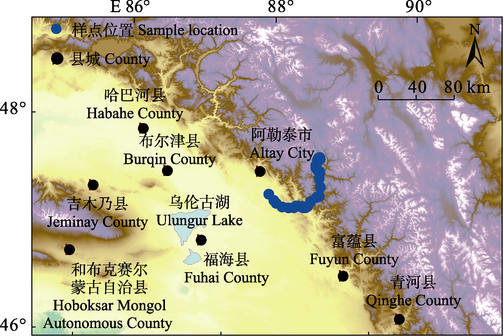
图1 新疆红山嘴地区孢粉取样点位置图。
Fig. 1 Study area and locations of the sporopollen sampling sites in the Hongshanzui region of Xinjiang.
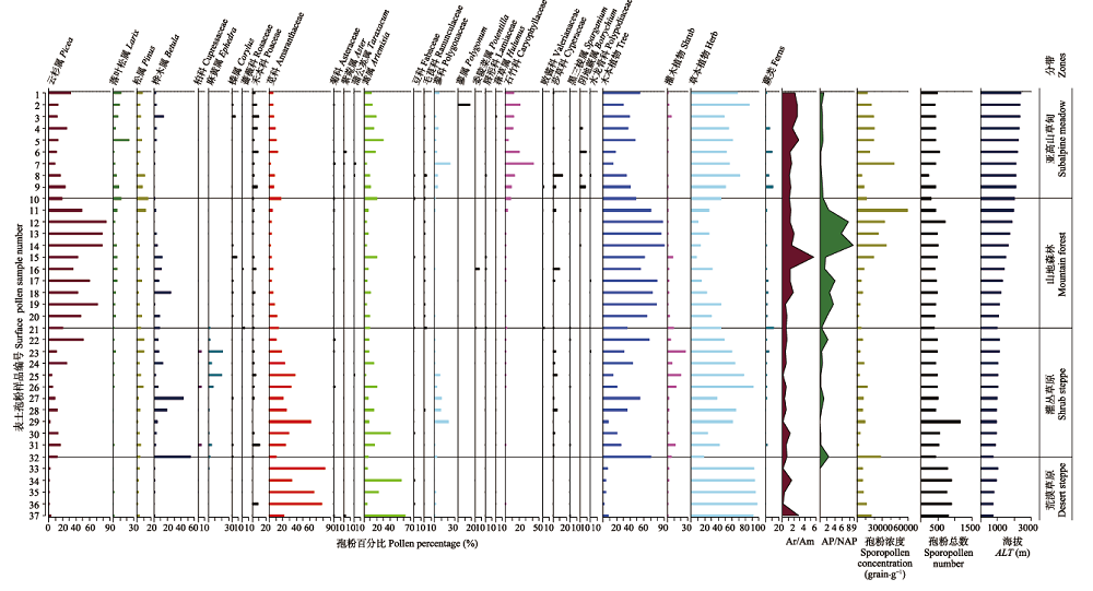
图2 新疆红山嘴地区表土孢粉组合图谱。图中菊科的孢粉百分比为排除蒿属、蒲公英属和紫菀属的数值; 蔷薇科和蓼科的孢粉百分比为分别排除委陵菜属和蓼属的数值。AP/NAP, 乔木与非乔木花粉比值; Ar/Am, 蒿属与苋科花粉比值。
Fig. 2 Surface sporopollen percentages and sporopollen zones of the Hongshanzui region in Xinjiang. The pollen percentages of Asteraceae in the figure are the values excluding Artemisia, Taraxacum and Aster; the pollen percentages of Rosaceae and Polygonaceae are the values excluding Potentilla and Polygonum, respectively. ALT, altitude; AP/NAP, arboreal pollen/non-arboreal pollen; Ar/Am, Artemisia/Amaranthaceac pollen.
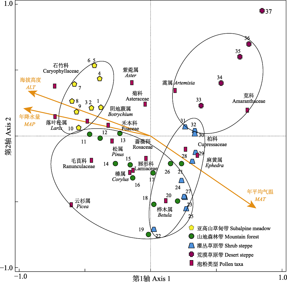
图3 新疆红山嘴地区主要孢粉类型与样点的RDA排序图。数字代表表土样点。
Fig. 3 Ordination of pollen sampling sites and sporopollen taxa of the Hongshanzui region in Xinjiang in the space of the first two axes of the redundancy analysis (RDA). ALT, altitude; MAP, mean annual precipitation; MAT, mean annual air temperature. Number means surface soil samples.
| 云杉属 Picea | 落叶松属 Larix | 苋科 Amaranthaceae | 毛茛科 Ranunculaceae | 石竹科 Caryophyllaceae | 阴地蕨属 Botrychium | |
|---|---|---|---|---|---|---|
| 海拔 Altitude | 0.218 | 0.663** | -0.553** | 0.274 | 0.674** | 0.408* |
| 年平均气温 Mean annual air temperature | -0.357* | -0.608** | 0.635** | -0.329* | -0.617** | -0.469** |
| 年降水量 Mean annual precipitation | 0.330* | 0.596** | -0.611** | 0.313 | 0.624** | 0.494** |
表1 新疆红山嘴地区6个孢粉类群与3个环境因子的相关分析
Table 1 Pearson correlations between the proportions of six sporopollen taxa and three environmental factors of the Hongshanzui region in Xinjiang
| 云杉属 Picea | 落叶松属 Larix | 苋科 Amaranthaceae | 毛茛科 Ranunculaceae | 石竹科 Caryophyllaceae | 阴地蕨属 Botrychium | |
|---|---|---|---|---|---|---|
| 海拔 Altitude | 0.218 | 0.663** | -0.553** | 0.274 | 0.674** | 0.408* |
| 年平均气温 Mean annual air temperature | -0.357* | -0.608** | 0.635** | -0.329* | -0.617** | -0.469** |
| 年降水量 Mean annual precipitation | 0.330* | 0.596** | -0.611** | 0.313 | 0.624** | 0.494** |
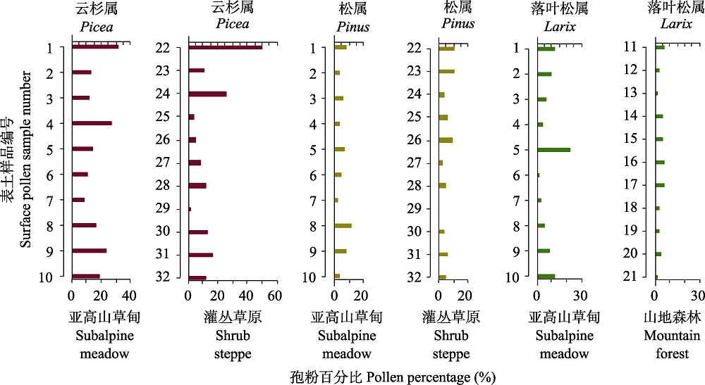
图4 新疆红山嘴地区乔木植物花粉与植被带的关系。
Fig. 4 Relationship between tree pollen and vegetation zones of the Hongshanzui region in Xinjiang.
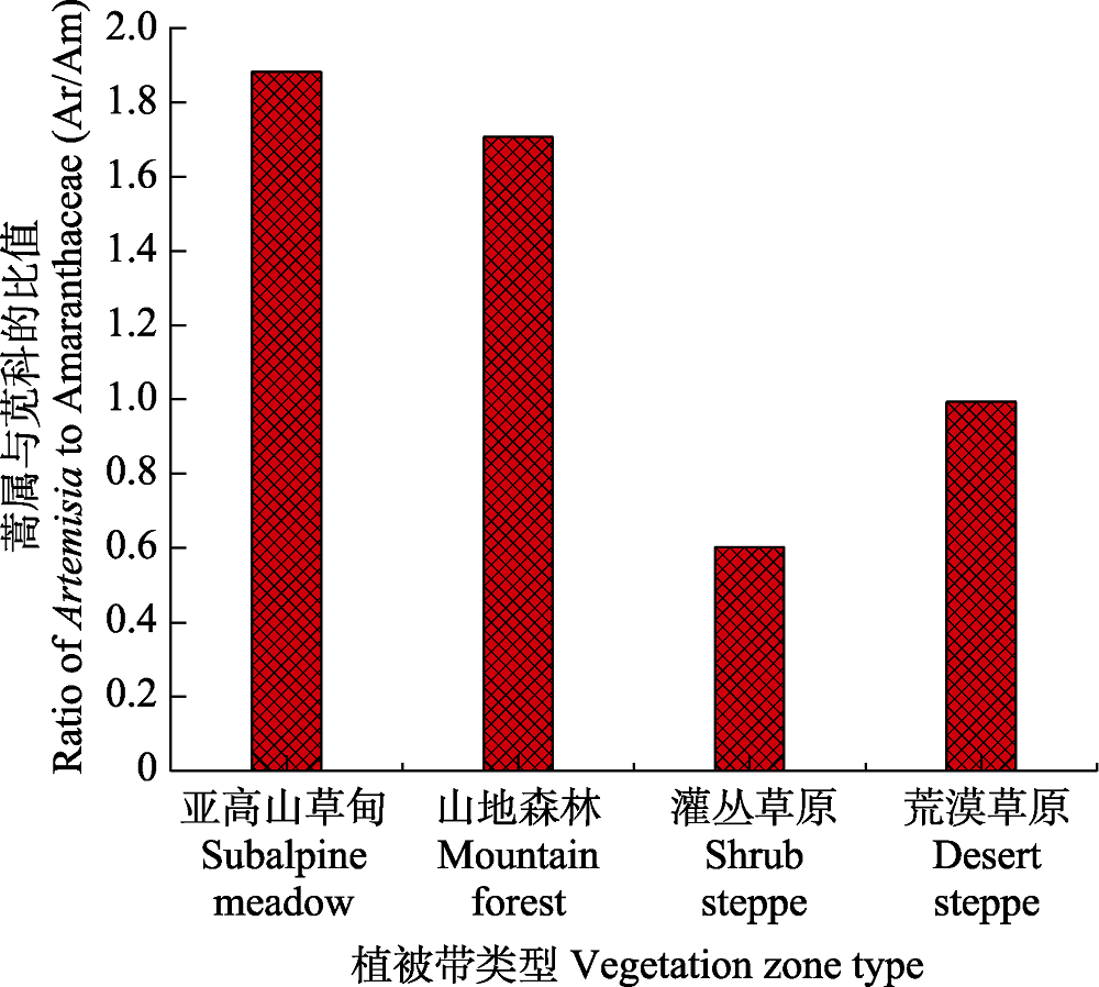
图5 新疆红山嘴地区4个孢粉组合带蒿属与苋科的比值。
Fig. 5 Ratio of Artemisia and Amaranthaceae in four sporopollen zones of the Hongshanzui region in Xinjiang.
| 海拔高度 Altitude (m) | MAT (℃) | MAP (mm) | ||
|---|---|---|---|---|
| 红山嘴 Hongshanzui | 喀纳斯西坡 Western slope of Kanas | 红山嘴 Hongshanzui | 喀纳斯西坡 Western slope of Kanas | |
| 600-800 | 3.38 | 3.82 | 180 | 181 |
| 800-1 000 | 2.66 | 2.24 | 190 | 195 |
| 1 000-1 200 | 1.64 | 1.10 | 206 | 213 |
| 1 200-1 400 | 0.33 | 0.09 | 222 | 229 |
| 1 400-1 600 | -1.75 | -2.00 | 257 | 264 |
表2 新疆红山嘴和喀纳斯西部相同海拔区间的年平均气温(MAT)和年降水量(MAP)(平均值)。
Table 2 Mean annual temperature (MAT) and mean annual precipitation (MAP)(mean) of the same altitude range in Hongshanzui and Western Kanas, Xinjiang
| 海拔高度 Altitude (m) | MAT (℃) | MAP (mm) | ||
|---|---|---|---|---|
| 红山嘴 Hongshanzui | 喀纳斯西坡 Western slope of Kanas | 红山嘴 Hongshanzui | 喀纳斯西坡 Western slope of Kanas | |
| 600-800 | 3.38 | 3.82 | 180 | 181 |
| 800-1 000 | 2.66 | 2.24 | 190 | 195 |
| 1 000-1 200 | 1.64 | 1.10 | 206 | 213 |
| 1 200-1 400 | 0.33 | 0.09 | 222 | 229 |
| 1 400-1 600 | -1.75 | -2.00 | 257 | 264 |
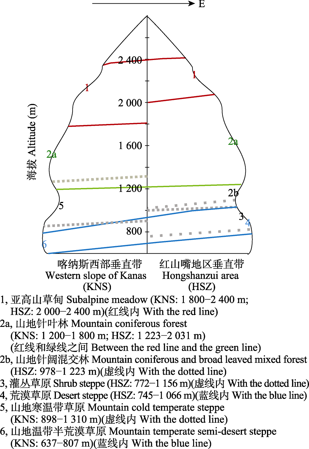
图6 新疆喀纳斯西坡与红山嘴地区孢粉垂直带对应的海拔。
Fig. 6 Comparison between the altitudes of different sporopollen vertical zones on western slopes of Kanas and Hongshanzui area, Xinjiang.
| [1] | Cao QM (2015). The Global Outstanding Universal Value of Plant Diversity in Altai Mountains, Xinjiang. Master degree dissertation, Xinjiang Agricultural University, Ürümqi. |
| [ 曹秋梅 (2015). 新疆阿尔泰山植物多样性全球突出普遍价值. 硕士学位论文, 新疆农业大学, 乌鲁木齐.] | |
| [2] |
Cao XY, Herzschuh U, Telford RJ, Ni J (2014). A modern pollen-climate dataset from China and Mongolia: assessing its potential for climate reconstruction. Review of Palaeobotany and Palynology, 211,87-96.
DOI URL |
| [3] |
Cao X, Tian F, Telford RJ, Ni J, Xu Q, Chen F, Liu X, Stebich M, Zhao Y, Herzschuh U (2017). Impacts of the spatial extent of pollen-climate calibration-set on the absolute values, range and trends of reconstructed Holocene precipitation. Quaternary Science Reviews, 178,37-53.
DOI URL |
| [4] | Chen YF, Yin LK, Cao QM, Wang Q (2016). Vegetation information extraction and analysis of Xinjiang Altay Two-River Source Nature Reserve. Arid Land Geography, 39,843-850. |
| [ 陈艳锋, 尹林克, 曹秋梅, 王琴 (2016). 新疆阿勒泰两河源自然保护区植被信息提取与分析. 干旱区地理, 39,843-850.] | |
| [5] | Du X (2019). Quantitative and Semi-Quantitative Relationship Between Surface Pollen and Climate on the Southern Slope of Altaimountains and Its Preliminary Application. Master degree dissertation, Lanzhou University, Lanzhou. |
| [ 杜璇 (2019). 阿尔泰山南坡表土花粉与气候定量、半定量关系及初步应用. 硕士学位论文, 兰州大学, 兰州.] | |
| [6] |
El-Moslimany AP (1990). Ecological significance of common nonarboreal pollen: examples from drylands of the Middle East. Review of Palaeobotany and Palynology, 64,343-350.
DOI URL |
| [7] | Gao Q, Liu T (2015). Causes and consequences of shrub encroachment in arid and semiarid region: a disputable issue. Arid Land Geography, 38,1202-1212. |
| [ 高琼, 刘婷 (2015). 干旱半干旱区草原灌丛化的原因及影响——争议与进展. 干旱区地理, 38,1202-1212.] | |
| [8] | Huang LP, Gao YQ, Li Y, Zhang TW, Hu DY, Wang L (2015). Growth of Siberia larch in the middle east of Altay Mountains and its response to climate change . Arid Land Geography, 38,1169-1178. |
| [ 黄力平, 高亚琪, 李云, 张同文, 胡东宇, 王蕾 (2015). 阿尔泰山中东部西伯利亚落叶松生长量及其对气候变化的响应研究. 干旱区地理, 38,1169-1178.] | |
| [9] |
Huang XZ, Chen XM, Du X (2018a). Modern pollen assemblages from human-influenced vegetation in northwestern China and their relationship with vegetation and climate. Vegetation History and Archaeobotany, 27,767-780.
DOI URL |
| [10] |
Huang X, Peng W, Rudaya N, Grimm EC, Chen X, Cao X, Zhang J, Pan X, Liu S, Chen C, Chen F (2018b). Holocene vegetation and climate dynamics in the Altai Mountains and surrounding areas. Geophysical Research Letters, 45,6628-6636.
DOI URL |
| [11] | Jiang JM (1990). The study of the geographical distribution of the Betula in China. Forest Research, 3,55-62. |
| [ 姜景民 (1990). 中国桦木属植物地理分布的研究. 林业科学研究, 3,55-62.] | |
| [12] | Jiang ZQ, Abbas A, Tumur A (2016). Study on the lichens species diversity in Hot spring valley forest park of Altay Mountain. Journal of Arid Land Resources and Environment, 30,121-126. |
| [ 姜泽群, 阿不都拉•阿巴斯, 艾尼瓦尔•吐米尔 (2016). 阿尔泰山温泉沟森林公园地衣物种多样性的研究. 干旱区资源与环境, 30,121-126.] | |
| [13] |
Lézine AM, Izumi K, Kageyama M, Achoundong G (2019). A 90000-year record of Afromontane forest responses to climate change. Science, 363,177-181.
DOI URL |
| [14] |
Li FR, Zhao Y, Gaillard MJ, Li H, Sun JH, Xu QH (2017). Modern pollen-climate relationships in north Xinjiang, northwestern China: implications for pollen-based reconstruction of Holocene climate. The Holocene, 27,951-966.
DOI URL |
| [15] | Li WY, Yao ZJ (1990). A study on the quantitative relationship between Pinus pollen in surface sample and Pinus vegetation . Acta Botanica Sinica, 32,943-950. |
| [ 李文漪, 姚祖驹 (1990). 表土中松属花粉与植物间数量关系的研究. 植物学报, 32,943-950.] | |
| [16] | Li YC, Xu QH, Xiao JL, Chen H, Lü XM (2005). Indicative study of pollen on transformation in the eastern desert region of China. Chinese Science Bulletin, 50,1356-1364. |
| [ 李月丛, 许清海, 肖举乐, 陈辉, 吕新苗 (2005). 中国荒漠区东部花粉对植被的指示性研究. 科学通报, 50,1356-1364.] | |
| [17] | Li YM (2015). Pollen Assemblages and Palaeoenvironment Change in the Typical Wetland of North Xinjiang, China. Master degree dissertation, Shijiazhuang University of Economics, Shijiazhuang. |
| [ 李玉梅 (2015). 新疆北部地区典型湿地孢粉组合与古环境研究. 硕士学位论文, 石家庄经济学院, 石家庄.] | |
| [18] | Li YM, Yang ZJ, Zhang Y, Yang QH, Liu LJ, Bi ZW, Wang CM, Kong ZC, Zhao L (2014). Surface pollen assemblages and vegetation relationships in the Bortala River Basin of Xinjiang, China. Scientia Geographica Sinica, 34,1518-1525. |
|
[ 李玉梅, 杨振京, 张芸, 杨庆华, 刘林敬, 毕志伟, 王成敏, 孔昭宸, 赵龙 (2014). 新疆博尔塔拉河表土孢粉组合与植被关系研究. 地理科学, 34,1518-1525.]
DOI |
|
| [19] | Li YY, Zhou LP, Cui HT (2008). Human active pollen indicator. Chinese Science Bulletin, 53,991-1002. |
| [ 李宜垠, 周力平, 崔海亭 (2008). 人类活动的孢粉指示体. 科学通报, 53,991-1002.] | |
| [20] | Luo CX, Zheng Z, Pan AD, An FZ, Beaudouin C, Huang KY (2007). Distribution of surface soil spore-pollen and its relationship with vegetation in Xinjiang, China. Arid Land Geography, 30,536-543. |
| [ 罗传秀, 郑卓, 潘安定, 安放舟, Beaudouin C, 黄康有 (2007). 新疆地区表土孢粉分布规律及其与植被关系研究. 干旱区地理, 30,536-543.] | |
| [21] |
Luo C, Zheng Z, Tarasov P, Pan A, Huang KY, Beaudouin C, An F (2009). Characteristics of the modern pollen distribution and their relationship to vegetation in the Xinjiang region, northwestern China. Review of Palaeobotany and Palynology, 153,282-295.
DOI URL |
| [22] |
Ma QF, Zhu LP, Lu XM, Wang Y, Guo Y, Wang JB, Ju JT, Peng P, Tang LY (2017). Modern pollen assemblages from surface lake sediments and their environmental implications on the southwestern Tibetan Plateau. Boreas, 46,242-253.
DOI URL |
| [23] |
Ni J, Cao XY, Jeltsch F, Herzschuh U (2014). Biome distribution over the last 22000 yr in China. Palaeogeography, Palaeoclimatology, Palaeoecology, 409,33-47.
DOI URL |
| [24] | Northwest Forestry Survey Planning and Design Institute of State Forestry Administration (2010). Investigation Report on Forest Resources Planning and Design of Fuhai Forest Farm of Xinjiang Altai Mountain State Owned Forest Administration Bureau. Xian. |
| [ 国家林业局西北林业调查规划设计院 (2010). 新疆阿尔泰山国有林管理局福海林场森林资源规划设计调查报告. 西安.] | |
| [25] | Sun FF, Zhang WY, Gong JC, Zhang CJ (2010). The palaeoenvironmental reconstruction on pollen proxy in the Qaidam Basin since Late Pliocene. Geological Review, 56,621-628. |
| [ 孙非非, 张菀漪, 巩俊成, 张成君 (2010). 柴达木盆地上新世晚期以来古气候演变的孢粉环境指标重建. 地质论评, 56,621-628.] | |
| [26] | Sun XJ, Du NQ, Weng CY, Lin RF, Wei KQ (1994). Paleovegetation and paleoenvironment of Manasi Lake, Xinjiang, N.W. China during the last 14000 Years. Quaternary Sciences, 3,239-248. |
| [ 孙湘君, 杜乃秋, 翁成郁, 林瑞芬, 卫克勤 (1994). 新疆玛纳斯湖盆周围近14000年以来的古植被古环境. 第四纪研究, 3,239-248.] | |
| [27] |
Wang L, Zhang Y, Kong ZC, Yang ZJ, Yan S, Li YC (2017). Preliminary study on pollen distribution in the surface soil of the Turpan region in the southern slope of Tianshan Mountains, Xinjiang. Chinese Journal of Plant Ecology, 41,779-786.
DOI URL |
|
[ 王力, 张芸, 孔昭宸, 杨振京, 阎顺, 李月丛 (2017). 新疆天山南坡吐鲁番地区表土花粉的初步研究. 植物生态学报, 41,779-786.]
DOI |
|
| [28] | Wei HC, Zheng Z, Ma HZ, Pan AD, Huang KY, Luo CX, Zheng YW, Wang ZY (2009). Pollen distribution patterns of surface soil sample in Qinghai of China and their relationship with vegetation. Arid Land Geography, 32,932-940. |
| [ 魏海成, 郑卓, 马海州, 潘安定, 黄康有, 罗传秀, 郑艳伟, 王志英 (2009). 青海表土花粉分布规律及其与植被的关系. 干旱区地理, 32,932-940.] | |
| [29] | Wu HX (2018). Pollen Assemblages of the Surface Soil and their Relationships with the Modern Vegetation and Climate in Northern Xinjiang. Master degree dissertation, University of Chinese Academy of Sciences (Institute of Earth Environment, Chinese Academy of Sciences), Beijing. |
| [ 吴慧贤 (2018). 北疆表土花粉组合及其与植被和气候的关系. 硕士学位论文, 中国科学院大学(中国科学院地球环境研究所), 北京.] | |
| [30] | Wu J (2006). A Preliminary Study on the Relationship Between Surface Pollen Assemblage and Modern Vegetation on Xinglong Mountain. Master degree dissertation, Lanzhou University, Lanzhou. |
| [ 伍婧 (2006). 兴隆山地区表土花粉与植被关系的研究. 硕士学位论文, 兰州大学, 兰州.] | |
| [31] | Wu JG, Lü JJ, Zhou QF (2010). Potential effects of climate change on the distribution of six desert plants in China. Chinese Bulletin of Botany, 45,723-738. |
|
[ 吴建国, 吕佳佳, 周巧富 (2010). 气候变化对6种荒漠植物分布的潜在影响. 植物学报, 45,723-738.]
DOI |
|
| [32] | Xu LL, Zhu BY (2017). Hongshanzui border post. Journal of the Western Mongolian Studies, 1,44-51. |
| [ 徐黎丽, 朱璧莹 (2017). 红山嘴边境口岸志. 西部蒙古论坛, 1,44-51.] | |
| [33] |
Xu Q, Zhang S, Gaillard MJ, Li M, Cao X, Tian F, Li F (2016). Studies of modern pollen assemblages for pollen dispersal- deposition-preservation process understanding and for pollen-based reconstructions of past vegetation, climate, and human impact: a review based on case studies in China. Quaternary Science Reviews, 149,151-166.
DOI URL |
| [34] | Xu YQ, Yan S, Jia BQ, Yang YL (1996). Numerical relationship between the surface spore-pollen and surrounding vegetation on the southern slope of Tianshan Mountions. Arid Land Geography, 19,24-30. |
| [ 许英勤, 阎顺, 贾宝全, 杨云良 (1996). 天山南坡表土孢粉分析及其与植被的数量关系. 干旱区地理, 19,24-30.] | |
| [35] | Yan S, Kong ZC, Yang ZJ, Zhang Y, Ni J (2004). Seeking relationship between vegetation and Picea pollen in surface soils of Xinjiang, northwestern China . Acta Ecologica Sinica, 24,2017-2023. |
| [ 阎顺, 孔昭宸, 杨振京, 张芸, 倪健 (2004). 新疆表土中云杉花粉与植被的关系. 生态学报, 24,2017-2023.] | |
| [36] | Yan S, Xu YQ (1989). Spore-pollen association in surface-soil in Altay, Xinjiang. Arid Zone Research, (1),26-33. |
| [ 阎顺, 许英勤 (1989). 新疆阿勒泰地区表土孢粉组合. 干旱区研究, (1),26-33.] | |
| [37] | Yang QH, Yang ZJ, Zhang Y, Bi ZW, Liu LJ, Song SY, Hou XH (2019). Relationship between surface sporepollen and modern vegetation in Xarxili Nature Reserve of Xinjiang. Arid Land Geography, 42,986-997. |
| [ 杨庆华, 杨振京, 张芸, 毕志伟, 刘林敬, 宋淑瑶, 侯献华 (2019). 新疆夏尔希里自然保护区表土孢粉与植被的关系. 干旱区地理, 42,986-997.] | |
| [38] |
Yang ZJ, Zhang Y, Ren HB, Yan S, Kong ZC, Ma KP, Ni J (2016). Altitudinal changes of surface pollen and vegetation on the north slope of the Middle Tianshan Mountains, China. Journal of Arid Land, 8,799-810.
DOI URL |
| [39] | Yuan GY (1986). The vertical zonation of the western Altay MTS. Acta Geographica Sinica, 41,32-40. |
|
[ 袁国映 (1986). 阿尔泰山西部地区的垂直自然带. 地理学报, 41,32-40.]
DOI |
|
| [40] |
Zhang Y, Kong ZC, Yan S, Yang ZJ, Ni J (2009). “Medieval Warm Period” on the northern slope of central Tianshan Mountains, Xinjiang, NW China. Geophysical Research Letters, 36,L11702. DOI: 10.1029/2009GL037375.
DOI URL |
| [41] |
Zhang Y, Kong ZC, Yan S, Yang ZJ, Ni J (2006). Fluctuation of Picea timber-line and paleo-environment on the northern slope of Tianshan Mountains during the late Holocene . Chinese Science Bulletin, 51,1747-1756.
DOI URL |
| [42] |
Zhang Y, Kong ZC, Zhang QB, Yang ZJ (2015). Holocene climate events inferred from modern and fossil pollen records in Butuo Lake, Eastern Qinghai-Tibetan Plateau. Climatic Change, 133,223-235.
DOI URL |
| [43] |
Zhang YJ, Duo L, Pang YZ, Felde VA, Birks HH, Birks HJB (2018). Modern pollen assemblages and their relationships to vegetation and climate in the Lhasa Valley, Tibetan Plateau, China. Quaternary International, 467,210-221.
DOI URL |
| [44] | Zhao KL (2013). Climatic Changes and Early Agricultural Activities since the Last Deglaciation in Xinjiang, NW China. Postdoctoral Dissertation, Chinese Academy of Sciences University, Beijing. |
| [ 赵克良 (2013). 新疆地区末次冰消期以来气候变化及早期农业活动. 博士后出站报告, 中国科学院大学, 北京.] | |
| [45] |
Zhao KL, Li XQ (2013). Modern pollen and vegetation relationships in the Yili Basin, Xinjiang, NW China. Chinese Science Bulletin, 58,4133-4142.
DOI URL |
| [ 赵克良, 李小强 (2013). 新疆伊犁盆地表土花粉与植被关系. 科学通报, 58,4133-4142.] | |
| [46] |
Zheng JY, Bian JJ, Ge QS, Hao ZX, Yin YH, Liao YM (2013). The climate regionalization in China for 1981-2010. Chinese Science Bulletin, 58,3088-3099.
DOI URL |
| [ 郑景云, 卞娟娟, 葛全胜, 郝志新, 尹云鹤, 廖要明 (2013). 1981-2010年中国气候区划. 科学通报, 58,3088-3099.] | |
| [47] | Zheng Z, Wei JH, Huang KY, Xu QH, Lu HY, Tarasov P, Luo CX, Beaudouin C, Deng Y, Pan AD, Zheng YW, Luo YL, Nakagawa T, Li CH, Yang SX, Peng HH, Cheddadi R (2014). East Asian polle n database: modern pollen distribution and its quantitative relationship with vegetation and climate. Journal of Biogeography, 41,1819-1832. |
| [48] | Zhong W, Shu Q, Xiong HG (2001). Pollen assemblages of Niya section in southern Xinjiang and paleoenvironmental evolution. Geographical Research, 20,91-96. |
| [ 钟巍, 舒强, 熊黑钢 (2001). 塔里木盆地南缘尼雅剖面的孢粉组合与环境. 地理研究, 20,91-96.] | |
| [49] | Zhuang XC, Zhang LH, Liu DF (2009). Analysis on characteristic of difference between ground and air temperature at Altai Region in Xinjiang. Meteorological and Environmental Sciences, 32(4),13-19. |
| [ 庄晓翠, 张林梅, 刘大锋 (2009). 新疆阿勒泰地区地气温差变化特征分析. 气象与环境科学, 32(4),13-19.] |
| [1] | 吴光进, 郭垚鑫, 任成杰, 王俊, 岳明, 赵发珠. 秦岭北麓不同植被类型土壤有机碳含量分布及其影响因素[J]. 植物生态学报, 2026, 50(预发表): 1-. |
| [2] | 田地, 迟小龙, 石亮, 刘宵含, 赵常提, 吴梅, 张玉忠, 高永亮. 塞罕坝地区优势造林树种叶片化学计量特征及其环境驱动[J]. 植物生态学报, 2026, 50(2): 362-373. |
| [3] | 韦鑫, 江蓝, 郑晨成, 朱静, 陈博, 李文周, 赖淑瑜, 刘金福, 何中声. 戴云山南坡海拔梯度上木本植物性系统分布特征及其影响因素[J]. 植物生态学报, 2026, 50(1): 150-159. |
| [4] | 黄美红, 牛梦秋, 杨鹏飞, 林洁, 廖周瑜, 陈建国, 向建英. 不同温度和埋藏深度对高山垫状植物山生福禄草种子出苗及幼苗生长的影响[J]. 植物生态学报, 2025, 49(12): 2092-2104. |
| [5] | 竹万宽, 许宇星, 黄润霞, 杜阿朋, 王志超. 雷州半岛桉树人工林生态系统水分利用效率旱雨季差异及其控制因素[J]. 植物生态学报, 2025, 49(12): 2015-2029. |
| [6] | 付照琦, 胡旭, 田沁瑞, 葛艳灵, 周红娟, 吴小云, 陈立欣. 晋西黄土区2种典型森林树种夜间液流特征及对环境因子的响应[J]. 植物生态学报, 2024, 48(9): 1128-1142. |
| [7] | 盘远方, 潘良浩, 邱思婷, 邱广龙, 苏治南, 史小芳, 范航清. 中国沿海红树林树高变异与环境适应机制[J]. 植物生态学报, 2024, 48(4): 483-495. |
| [8] | 王丽丽, 宋晓彤, 谷际岐, 邵小明. 西藏尖叶对齿藓形态特征与环境变化的关系及响应策略[J]. 植物生态学报, 2024, 48(10): 1351-1360. |
| [9] | 赵孟娟, 金光泽, 刘志理. 阔叶红松林3种典型蕨类叶功能性状的垂直变异[J]. 植物生态学报, 2023, 47(8): 1131-1143. |
| [10] | 李安艳, 黄先飞, 田源斌, 董继兴, 郑菲菲, 夏品华. 贵州草海草-藻型稳态转换过程中叶绿素a的变化及其影响因子[J]. 植物生态学报, 2023, 47(8): 1171-1181. |
| [11] | 杨丽琳, 邢万秋, 王卫光, 曹明珠. 新安江源区杉木树干液流速率变化及其对环境因子的响应[J]. 植物生态学报, 2023, 47(4): 571-583. |
| [12] | 贺洁, 何亮, 吕渡, 程卓, 薛帆, 刘宝元, 张晓萍. 2001-2020年黄土高原光合植被时空变化及其驱动机制[J]. 植物生态学报, 2023, 47(3): 306-318. |
| [13] | 赵镇贤, 陈银萍, 王立龙, 王彤彤, 李玉强. 河西走廊荒漠区不同功能类群植物叶片建成成本的比较[J]. 植物生态学报, 2023, 47(11): 1551-1560. |
| [14] | 张潇, 武娟娟, 贾国栋, 雷自然, 张龙齐, 刘锐, 吕相融, 代远萌. 降水控制对侧柏液流变化特征及其水分来源的影响[J]. 植物生态学报, 2023, 47(11): 1585-1599. |
| [15] | 郑宁, 李素英, 王鑫厅, 吕世海, 赵鹏程, 臧琛, 许玉珑, 何静, 秦文昊, 高恒睿. 基于环境因子对叶绿素影响的典型草原植物生活型优势研究[J]. 植物生态学报, 2022, 46(8): 951-960. |
| 阅读次数 | ||||||
|
全文 |
|
|||||
|
摘要 |
|
|||||
Copyright © 2026 版权所有 《植物生态学报》编辑部
地址: 北京香山南辛村20号, 邮编: 100093
Tel.: 010-62836134, 62836138; Fax: 010-82599431; E-mail: apes@ibcas.ac.cn, cjpe@ibcas.ac.cn
备案号: 京ICP备16067583号-19
![]()