
植物生态学报 ›› 2017, Vol. 41 ›› Issue (7): 779-786.DOI: 10.17521/cjpe.2017.0019 cstr: 32100.14.cjpe.2017.0019
王力1,2,3, 张芸1,*( ), 孔昭宸1, 杨振京4, 阎顺5, 李月丛3
收稿日期:2017-01-21
接受日期:2017-06-01
出版日期:2017-07-10
发布日期:2017-08-21
作者简介:* 通信作者Author for correspondence (E-mail:
基金资助:
Li WANG1,2,3, Yun ZHANG1,*(), Zhao-Chen KONG1, Zhen-Jing YANG4, Shun YAN5, Yue-Cong LI3
Received:2017-01-21
Accepted:2017-06-01
Online:2017-07-10
Published:2017-08-21
About author:KANG Jing-yao(1991-), E-mail:
摘要:
基于对新疆天山东段南坡吐鲁番地区选取的一条沿着海拔高度从2 000- -154 m的不同植被带的植物群落样方进行的调查及相应排序分析, 结合所采集的36个现代表土花粉样品的孢粉组合图式, 初步研究了吐鲁番地区的植被与表土花粉之间的对应关系, 并将其与天山北坡的表土花粉谱进行了比较。结果表明吐鲁番地区表土花粉谱按照海拔高度自上至下可划分为4个孢粉组合带, 分别对应于山地荒漠草原和荒漠带、戈壁砾石带、典型荒漠带以及盐沼植被带。与天山北坡的表土花粉垂直带谱相比, 吐鲁番地区的花粉垂直带谱并不完整, 缺少典型的森林和蒿属(Artemisia)荒漠孢粉带。即使在相似的孢粉带, 吐鲁番地区的分布高度也高出北坡300 m左右。典型的乔木植物云杉属(Picea)、松属(Pinus)花粉在风力和水流的作用下, 表现出明显的超代表性; 用来指示干旱区半干旱区气候湿度变化的蒿属与藜科花粉的比值能大致反映出荒漠带的典型特征。此外, 研究区内表土花粉组合与环境因子之间的排序分析结果表明, 降水量是影响该区表土花粉组合的主要环境因子。与蒿属、藜科花粉相比, 白刺属(Nitraria)花粉受降水量的影响较大。
王力, 张芸, 孔昭宸, 杨振京, 阎顺, 李月丛. 新疆天山南坡吐鲁番地区表土花粉的初步研究. 植物生态学报, 2017, 41(7): 779-786. DOI: 10.17521/cjpe.2017.0019
Li WANG, Yun ZHANG, Zhao-Chen KONG, Zhen-Jing YANG, Shun YAN, Yue-Cong LI. Preliminary study on pollen distribution in the surface soil of the Turpan region in the southern slope of Tianshan Mountains, Xinjiang, China. Chinese Journal of Plant Ecology, 2017, 41(7): 779-786. DOI: 10.17521/cjpe.2017.0019
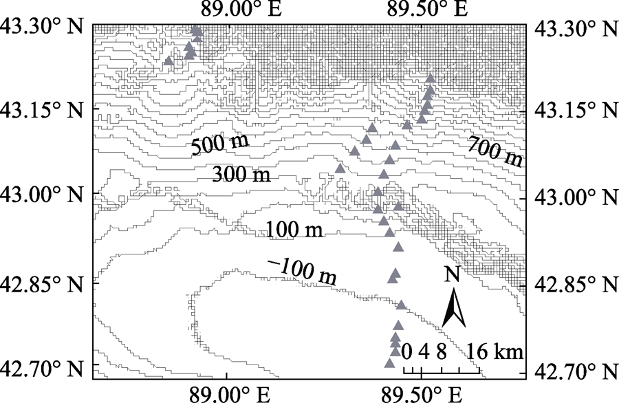
图1 新疆吐鲁番地区表土花粉采样点。图中等值线上的数字表示该处的海拔高度, 其间隔为100 m。三角表示采 样点。
Fig. 1 Study area and locations of the pollen sampling sites in the Turpan region of Xinjiang. The contour lines represent elevation. The contour interval is 100 m. The triangles represent sampling sites.
| 样号 Sample | 海拔 Altitude (m) | 植被带类型 Vegetation zone | 样号 Sample | 海拔 Altitude (m) | 植被带类型 Vegetation zone |
|---|---|---|---|---|---|
| 1 | 1 990 | 山地荒漠草原和荒漠植被带 Mountain desert-steppe and desert | 19 | 500 | 戈壁砾石带 Gobi gravel |
| 2 | 1 936 | 山地荒漠草原和荒漠植被带 Mountain desert-steppe and desert | 20 | 400 | 戈壁砾石带 Gobi gravel |
| 3 | 1 850 | 山地荒漠草原和荒漠植被带 Mountain desert-steppe and desert | 21 | 400 | 戈壁砾石带 Gobi gravel |
| 4 | 1 700 | 山地荒漠草原和荒漠植被带 Mountain desert-steppe and desert | 22 | 260 | 典型荒漠带 Typical desert |
| 5 | 1 600 | 山地荒漠草原和荒漠植被带 Mountain desert-steppe and desert | 23 | 300 | 典型荒漠带 Typical desert |
| 6 | 1 500 | 山地荒漠草原和荒漠植被带 Mountain desert-steppe and desert | 24 | 220 | 典型荒漠带 Typical desert |
| 7 | 1 400 | 山地荒漠草原和荒漠植被带 Mountain desert-steppe and desert | 25 | 100 | 典型荒漠带 Typical desert |
| 8 | 1 300 | 山地荒漠草原和荒漠植被带 Mountain desert-steppe and desert | 26 | -45 | 盐沼植被带 Salt mash vegetation |
| 9 | 1 200 | 山地荒漠草原和荒漠植被带 Mountain desert-steppe and desert | 27 | -160 | 盐沼植被带 Salt mash vegetation |
| 10 | 1 300 | 山地荒漠草原和荒漠植被带 Mountain desert-steppe and desert | 28 | -180 | 盐沼植被带 Salt mash vegetation |
| 11 | 1 120 | 山地荒漠草原和荒漠植被带 Mountain desert-steppe and desert | 29 | -180 | 盐沼植被带 Salt mash vegetation |
| 12 | 1 100 | 山地荒漠草原和荒漠植被带 Mountain desert-steppe and desert | 30 | -90 | 盐沼植被带 Salt mash vegetation |
| 13 | 1 010 | 山地荒漠草原和荒漠植被带 Mountain desert-steppe and desert | 31 | -110 | 盐沼植被带 Salt mash vegetation |
| 14 | 900 | 戈壁砾石带 Gobi gravel | 32 | -130 | 盐沼植被带 Salt mash vegetation |
| 15 | 730 | 戈壁砾石带 Gobi gravel | 33 | -120 | 盐沼植被带 Salt mash vegetation |
| 16 | 630 | 戈壁砾石带 Gobi gravel | 34 | -130 | 盐沼植被带 Salt mash vegetation |
| 17 | 510 | 戈壁砾石带 Gobi gravel | 35 | -140 | 盐沼植被带 Salt mash vegetation |
| 18 | 600 | 戈壁砾石带 Gobi gravel | 36 | -150 | 盐沼植被带 Salt mash vegetation |
表1 新疆吐鲁番地区各样品对应的海拔与现代植被带类型
Table 1 Altitude and vegetation zone of all samples from Turpan region of Xinjiang
| 样号 Sample | 海拔 Altitude (m) | 植被带类型 Vegetation zone | 样号 Sample | 海拔 Altitude (m) | 植被带类型 Vegetation zone |
|---|---|---|---|---|---|
| 1 | 1 990 | 山地荒漠草原和荒漠植被带 Mountain desert-steppe and desert | 19 | 500 | 戈壁砾石带 Gobi gravel |
| 2 | 1 936 | 山地荒漠草原和荒漠植被带 Mountain desert-steppe and desert | 20 | 400 | 戈壁砾石带 Gobi gravel |
| 3 | 1 850 | 山地荒漠草原和荒漠植被带 Mountain desert-steppe and desert | 21 | 400 | 戈壁砾石带 Gobi gravel |
| 4 | 1 700 | 山地荒漠草原和荒漠植被带 Mountain desert-steppe and desert | 22 | 260 | 典型荒漠带 Typical desert |
| 5 | 1 600 | 山地荒漠草原和荒漠植被带 Mountain desert-steppe and desert | 23 | 300 | 典型荒漠带 Typical desert |
| 6 | 1 500 | 山地荒漠草原和荒漠植被带 Mountain desert-steppe and desert | 24 | 220 | 典型荒漠带 Typical desert |
| 7 | 1 400 | 山地荒漠草原和荒漠植被带 Mountain desert-steppe and desert | 25 | 100 | 典型荒漠带 Typical desert |
| 8 | 1 300 | 山地荒漠草原和荒漠植被带 Mountain desert-steppe and desert | 26 | -45 | 盐沼植被带 Salt mash vegetation |
| 9 | 1 200 | 山地荒漠草原和荒漠植被带 Mountain desert-steppe and desert | 27 | -160 | 盐沼植被带 Salt mash vegetation |
| 10 | 1 300 | 山地荒漠草原和荒漠植被带 Mountain desert-steppe and desert | 28 | -180 | 盐沼植被带 Salt mash vegetation |
| 11 | 1 120 | 山地荒漠草原和荒漠植被带 Mountain desert-steppe and desert | 29 | -180 | 盐沼植被带 Salt mash vegetation |
| 12 | 1 100 | 山地荒漠草原和荒漠植被带 Mountain desert-steppe and desert | 30 | -90 | 盐沼植被带 Salt mash vegetation |
| 13 | 1 010 | 山地荒漠草原和荒漠植被带 Mountain desert-steppe and desert | 31 | -110 | 盐沼植被带 Salt mash vegetation |
| 14 | 900 | 戈壁砾石带 Gobi gravel | 32 | -130 | 盐沼植被带 Salt mash vegetation |
| 15 | 730 | 戈壁砾石带 Gobi gravel | 33 | -120 | 盐沼植被带 Salt mash vegetation |
| 16 | 630 | 戈壁砾石带 Gobi gravel | 34 | -130 | 盐沼植被带 Salt mash vegetation |
| 17 | 510 | 戈壁砾石带 Gobi gravel | 35 | -140 | 盐沼植被带 Salt mash vegetation |
| 18 | 600 | 戈壁砾石带 Gobi gravel | 36 | -150 | 盐沼植被带 Salt mash vegetation |
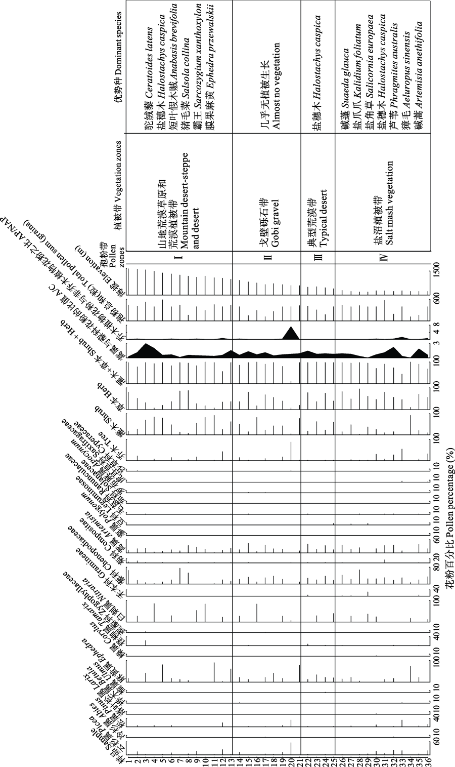
图2 新疆吐鲁番地区表土花粉组合图式。I, 山地荒漠草原和荒漠植被带(1 000-2 000 m); II, 戈壁砾石带(400-1 000 m); III, 典型荒漠带(0-400 m); IV, 盐沼植被带(-154-0 m)。
Fig. 2 The pollen percentages and pollen zones in the surface soil in the Turpan region of Xinjiang. A/C, the pollen ratio of Artemisia to Chenopodiaceae; AP/NAP, the ratio of arboreal pollen to non-arboreal pollen. I, mountain desert-steppe and desert (1 000-2 000 m); II, Gobi gravel (400-1 000 m); III, typical desert (0-400 m); IV, salt mash vegetation (-154-0 m).
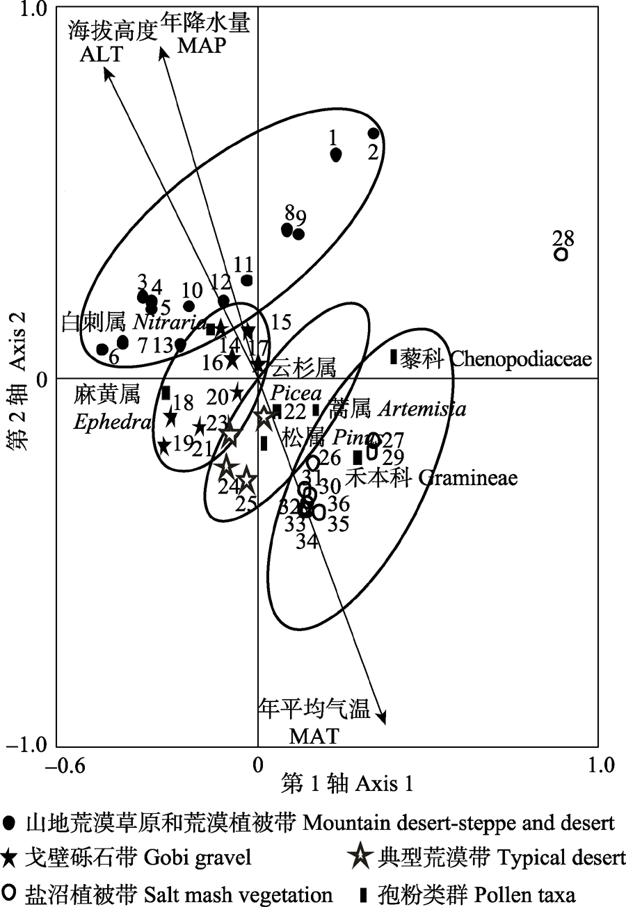
图3 主要花粉与样点的RDA排序图。
Fig. 3 RDA results of pollen sampling sites and pollen taxa. ALT, altitude; MAP, annual precipitation; MAT, annual average temperature.
| [1] | Comprehensive Expedition of Xinjiang, Chinese Academy of Sciences, Institute of Botany, Chinese Academy of Sciences (1978). Vegetation of Xinjiang and Its Utilization. Science Press, Beijing. (in Chinese)[中国科学院新疆综合考察队, 中国科学院植物研究所 (1978). 新疆植被及其利用. 科学出版社, 北京.] |
| [2] | Du NQ, Kong ZC (1983). Palynoflora of the Qarhan Saline Lake and its signification in geography and botany the spore-pollen assemblages from CK2022 drilling core at the Bieletan.Acta Botanica Sinica, 25, 275-282. (in Chinese with English abstract)[杜乃秋, 孔昭宸 (1983). 青海柴达木盆地察尔汗盐湖的孢粉组合及其在地理和植物学的意义. 植物学报, 25, 275-282.] |
| [3] | El-Moslinmany AP (1990). Ecological significance of common nonarboreal pollen: Examples from drylands of the Middle East.Review of Palaeobotany and Palynology, 64, 343-350. |
| [4] | Hu RJ (2004). Physical geography of the Tianshan Mountains in China. China Environmental Science Press, Beijing. 338-339. (in Chinese)[胡汝骥 (2004). 中国天山自然地理. 中国环境科学出版社, 北京. 338-339.] |
| [5] | Hutchinson MF (2006). ANUSPLIN Version 4.36 User Guide. Centre for Resource and Environmental Studies, the Australian National University, Canberra. |
| [6] | Li WY (1998). Quaternary Vegetation and Environment in China. Science Press, Beijing. 2-30, 43-48. (in Chinese)[李文漪 (1998). 中国第四纪植被与环境. 科学出版社, 北京. 2-30, 43-48.] |
| [7] | Li WY, Yao ZJ (1990). A study on the quantitative relationship between Pinus pollen in surface sample and Pinus vegetation.Acta Botanica Sinica, 32, 943-950. (in Chinese with English abstract)[李文漪, 姚祖驹 (1990). 表土中松属花粉与植物间数量关系的研究. 植物学报, 32, 943-950.] |
| [8] | Luo CX, Zheng Z, Pan AD, An FZ, Beaudouin C, Huang KY (2008). Spatial distribution of modern pollen in Xinjiang region.Scientia Geographica Sinica, 28, 272-275. (in Chinese with English abstract)[罗传秀, 郑卓, 潘安定, 安放舟, Beaudouin C, 黄康有 (2008). 新疆地区表土孢粉空间分布规律研究. 地理科学, 28, 272-275.] |
| [9] | Luo CX, Zheng Z, Tarasov P, Pan AD, Huang KY, Beaudouin C, An FZ (2009). Characteristics of the modern pollen distribution and their relationship to vegetation in the Xinjiang region, northwestern China.Review of Palaeobotany and Palynology, 153, 282-295. |
| [10] | Mauri A, Davis BAS, Collins PM, Kaplan JO (2015). The climate of Europe during the Holocene: A gridded pollen-based reconstruction and its multi-proxy evaluation.Quaternary Science Reviews, 112, 109-127. |
| [11] | Schäbitz F, Wille M, Francois J-P, Haberzettl T, Quintana F, Mayr C, Lücke A, Ohlendorf C, Mancini V, Paez MM, Prieto AR, Zolitschka B (2013). Reconstruction of palaeoprecipitation based on pollen transfer functions—The record of the last 16 ka from Laguna Potrok Aike, southern Patagonia.Quaternary Science Reviews, 71, 175-190. |
| [12] | Sun XJ, Du NQ, Weng CY, Lin RF, Wei KQ (1994). Paleovegetation and paleoenvironment of Manasi Lake, Xinjiang, N.W. China during the last 14000 years.Quaternary Sciences, (3), 239-247. (in Chinese with English abstract)[孙湘君, 杜乃秋, 翁成郁, 林瑞芬, 卫克勤 (1994). 新疆玛纳斯湖盆周围近14000年以来的古植被环境. 第四纪研究, (3), 239-247.] |
| [13] | Suo YR (2010). Research and Development of Nitraria in Qaidam Basin. Science Press, Beijing. 113-116. (in Chinese)[索有瑞 (2010). 柴达木盆地白刺研究与开发. 科学出版社, 北京. 113-116.] |
| [14] | Wang YJ, Wu SF (2003). Environment change over the Aydingkol lake region in Turpan Basin, Xinjiang.Journal of Glaciology and Geocryology, 25, 229-231. (in Chinese with English abstract)[王亚俊, 吴素芬 (2003). 新疆吐鲁番盆地艾丁湖的环境变化. 冰川冻土, 25, 229-231.] |
| [15] | Wei HC, Zhao Y (2015). Surface pollen and its relationships with modern vegetation and climate in the Tianshan Mountains, northwestern China.Vegetation History and Archaeobotany, 25, 19-27. |
| [16] | Xu YQ, Yan S, Jia BQ, Yang YL (1996). Numerical relationship between the surface spore-pollen and surrounding vegetation on the southern slope of Tianshan Mountains.Arid Land Geography, 19(3), 24-30. (in Chinese with English abstract)[许英勤, 阎顺, 贾宝全, 杨云良 (1996). 天山南坡表土孢粉分析及其与植被的数量关系.干旱区地理, 19(3), 24-30.] |
| [17] | Yan S (1993). The discussion on the pollen of pine family in surface soil in Xinjiang.Arid Land Geography, 16(3), 1-9. (in Chinese with English abstract)[阎顺 (1993). 新疆表土松科花粉分布的探讨. 干旱区地理, 16(3), 1-9.] |
| [18] | Yan S, Jia BQ, Xu YQ, Yang YL (1996). The surface sampling of vegetation and pollen in the source area of the Ürümqi River.Journal of Glaciology and Geocryology, 18(Suppl.), 264-273. (in Chinese with English abstract)[阎顺, 贾宝全, 许英勤, 杨云良 (1996). 乌鲁木齐河源区植被及表土花粉. 冰川冻土, 18(增刊), 264-273.] |
| [19] | Yan S, Kong ZC, Yang ZJ, Zhang Y, Ni J (2004). Seeking relationship between vegetation and Picea pollen in surface soils of Xinjiang, northwestern China.Acta Ecologica Sinica, 24, 2017-2023. (in Chinese with English abstract)[阎顺, 孔昭宸, 杨振京, 张芸, 倪健 (2004). 表土中云杉花粉与植被的关系. 生态学报, 24, 2017-2023.] |
| [20] | Yang ZJ (2004). Altitudinal Changes of Modern Pollen and Vegetation on the Northern Slope of the Mid-Tianshan Mt., Northwestern Dryland of China. PhD dissertation, Institute of Botany, Chinese Academy of Sciences, Beijing. (in Chinese with English abstract)[杨振京 (2004). 天山中段北坡不同海拔高度的表土花粉与植被. 博士学位论文, 中国科学院植物研究所, 北京.] |
| [21] | Yang ZJ, Zhang Y, Bi ZW, Yang QH, Kong ZC, Yan S, Yan MJ (2011). Surface pollen distribution in the southern slope of Tianshan Mountains, Xinjiang.Arid Land Geography, 34, 880-889. (in Chinese with English abstract)[杨振京, 张芸, 毕志伟, 杨庆华, 孔昭宸, 阎顺, 严明疆 (2011). 新疆天山南坡表土花粉的初步研究. 干旱区地理, 34, 880-889.] |
| [22] | Yang ZJ, Zhang Y, Ren HB, Yan S, Kong ZC, Ma KP, Ni J (2016). Altitudinal changes of surface pollen and vegetation on the north slope of the Middle Tianshan Mountains, China.Journal of Arid Land, 8, 799-810. |
| [23] | Zhang H, Zhang Y, Kong ZC, Yang ZJ, Li YM, Tarasov, Pavel E (2015a). Late Holocene climate change and anthropogenic activities in north Xinjiang: Evidence from a peatland archive, the Caotanhu wetland.The Holocene, 25, 323-332. |
| [24] | Zhang H, Zhang Y, Yang ZJ, Yan P, Kong ZC, Yan S (2013). Surface pollen research of Nanshan region, Shihezi City in Xinjiang.Acta Ecologica Sinica, 33, 6478-6487. (in Chinese with English abstract)[张卉, 张芸, 杨振京, 阎平, 孔昭宸, 阎顺 (2013). 新疆石河子南山地区表土花粉研究. 生态学报, 33, 6478-6487.] |
| [25] | Zhang XQ (1998). Topography and weather in Turpan Basin.Bimonthly of Xinjiang Meteorology, 21(6), 11-13. (in Chinese)[张新庆 (1998). 吐鲁番盆地地形与天气. 新疆气象, 21(6), 11-13.] |
| [26] | Zhang Y, Kong ZC, Wang GH, Ni J (2010). Anthropogenic and climatic influence on surface pollen assemblages along precipitation gradient in northeastern China.Global Ecology and Biogeography, 19, 621-631. |
| [27] | Zhang Y, Kong ZC, Yang ZJ, Wang L, Duan XH (2017). Surface pollen distribution from alpine vegetation in Eastern Tibet, China.Scientific Reports, 7, 586.Zhang Y, Kong ZC, Zhang QB, Yang ZJ (2015b). Holocene climate events inferred from modern and fossil pollen records in Butuo Lake, Eastern Qinghai-Tibetan Plateau.Climatic Change, 133, 223-235. |
| [1] | 贾妍妍, 柳华清, 解欣然, 王博, 张维, 杨允菲. 珍稀濒危植物天山梣林龄结构及种群动态[J]. 植物生态学报, 2025, 49(5): 760-772. |
| [2] | 张鹏, 焦亮, 薛儒鸿, 魏梦圆, 杜达石, 吴璇, 王旭鸽, 李倩. 干旱强度影响祁连山西段不同海拔青海云杉的生长恢复[J]. 植物生态学报, 2024, 48(8): 977-987. |
| [3] | 陈以恒, 玉素甫江•如素力, 阿卜杜热合曼•吾斯曼. 2001-2020年天山新疆段草地植被覆盖度时空变化及驱动因素分析[J]. 植物生态学报, 2024, 48(5): 561-576. |
| [4] | 吴瀚, 白洁, 李均力, 古丽•加帕尔, 包安明. 新疆地区植被覆盖度时空变化及其影响因素分析[J]. 植物生态学报, 2024, 48(1): 41-55. |
| [5] | 郭敏, 罗林, 梁进, 王彦杰, 赵春章. 冻融变化对西南亚高山森林优势种云杉和华西箭竹根区土壤理化性质与酶活性的影响[J]. 植物生态学报, 2023, 47(6): 882-894. |
| [6] | 石荡, 郭传超, 蒋南林, 唐莹莹, 郑凤, 王瑾, 廖康, 刘立强. 新疆野杏天然更新幼株的个体特征及空间分布格局[J]. 植物生态学报, 2023, 47(4): 515-529. |
| [7] | 赵长兴, 赵维俊, 张兴林, 刘思敏, 牟文博, 刘金荣. 祁连山排露沟流域青海云杉种群种内竞争与促进作用分析[J]. 植物生态学报, 2022, 46(9): 1027-1037. |
| [8] | 张宏祥, 闻志彬, 王茜. 新疆野苹果种群遗传结构及其环境适应性[J]. 植物生态学报, 2022, 46(9): 1098-1108. |
| [9] | 董六文, 任正炜, 张蕊, 谢晨笛, 周小龙. 功能多样性比物种多样性更好解释氮添加对高寒草地生物量的影响[J]. 植物生态学报, 2022, 46(8): 871-881. |
| [10] | 陈丽, 田新民, 任正炜, 董六文, 谢晨笛, 周小龙. 养分添加对天山高寒草地植物多样性和地上生物量的影响[J]. 植物生态学报, 2022, 46(3): 280-289. |
| [11] | 秦慧君, 焦亮, 周怡, 薛儒鸿, 柒常亮, 杜达石. 祁连山优势树木碳水化合物资源分配的海拔和树种效应[J]. 植物生态学报, 2022, 46(2): 208-219. |
| [12] | 杜军, 王文, 何志斌, 陈龙飞, 蔺鹏飞, 朱喜, 田全彦. 祁连山青海云杉物候表型的空间分异及其内在机制[J]. 植物生态学报, 2021, 45(8): 834-843. |
| [13] | 张欢, 张云玲, 张彦才, 阎平. 新疆奇台荒漠类草地自然保护区主要植物群落及其特征[J]. 植物生态学报, 2021, 45(8): 918-924. |
| [14] | 罗林, 黄艳, 梁进, 汪恩涛, 胡君, 贺合亮, 赵春章. 西南亚高山针叶林主要树种互作及增温对根区土壤微生物群落的影响[J]. 植物生态学报, 2020, 44(8): 875-884. |
| [15] | 赵阳, 刘锦乾, 陈学龙, 杨萌萌, 曹家豪, 齐瑞, 曹秀文. 洮河上游紫果云杉种群结构特征[J]. 植物生态学报, 2020, 44(3): 266-276. |
| 阅读次数 | ||||||
|
全文 |
|
|||||
|
摘要 |
|
|||||
Copyright © 2026 版权所有 《植物生态学报》编辑部
地址: 北京香山南辛村20号, 邮编: 100093
Tel.: 010-62836134, 62836138; Fax: 010-82599431; E-mail: apes@ibcas.ac.cn, cjpe@ibcas.ac.cn
备案号: 京ICP备16067583号-19
![]()