
Chin J Plant Ecol ›› 2005, Vol. 29 ›› Issue (6): 934-944.DOI: 10.17521/cjpe.2005.0115
• Research Articles • Previous Articles Next Articles
YU Feng1,2, LI Xiao-Bing1,*( ), WANG Hong1, YU Hong-Jing1, CHEN Yun-Hao1
Accepted:2004-09-21
Published:2005-09-30
Contact:
LI Xiao-Bing
YU Feng, LI Xiao-Bing, WANG Hong, YU Hong-Jing, CHEN Yun-Hao. LAND COVER CLASSIFICATION IN CHINA BASED ON THE NDVI-T<sub>S</sub> FEATURE SPACE[J]. Chin J Plant Ecol, 2005, 29(6): 934-944.
Add to citation manager EndNote|Ris|BibTeX
URL: https://www.plant-ecology.com/EN/10.17521/cjpe.2005.0115
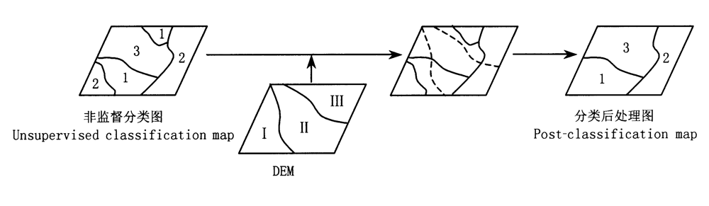
Fig.1 Post-classification based on DEM
| 主成分 Principal component | NDVI、Ts和Ts/NDVI主成分变换特征向量 Eigenvectors of principal components for NDVI,Ts and Ts/NDVI | 方差(%) Expressed variance | ||||||||||||||||||
|---|---|---|---|---|---|---|---|---|---|---|---|---|---|---|---|---|---|---|---|---|
| 1 | 2 | 3 | 4 | 5 | 6 | 7 | 8 | 9 | 10 | 11 | 12 | |||||||||
| NDVI | PC1 | 0.26 | 0.26 | 0.27 | 0.27 | 0.29 | 0.31 | 0.32 | 0.32 | 0.31 | 0.29 | 0.28 | 0.27 | 81 | ||||||
| PC2 | 0.25 | 0.32 | 0.36 | 0.13 | -0.12 | -0.33 | -0.40 | -0.37 | -0.26 | 0.05 | 0.25 | 0.37 | 14.7 | |||||||
| PC3 | -0.44 | -0.15 | 0.07 | -0.54 | -0.08 | 0.31 | -0.05 | -0.17 | 0.01 | 0.36 | 0.36 | 0.29 | 1.5 | |||||||
| PC4 | -0.05 | -0.14 | -0.16 | 0.29 | 0.67 | 0.35 | -0.22 | -0.41 | -0.25 | 0.04 | 0.03 | -0.13 | 1.4 | |||||||
| Ts | PC1 | 0.13 | 0.19 | 0.25 | 0.32 | 0.36 | 0.37 | 0.36 | 0.36 | 0.33 | 0.28 | 0.20 | 0.15 | 96.5 | ||||||
| PC2 | -0.52 | -0.41 | -0.21 | 0.01 | 0.17 | 0.23 | 0.23 | 0.20 | 0.11 | -0.04 | -0.29 | -0.49 | 3.0 | |||||||
| Ts/NDVI | PC1 | 0.13 | 0.19 | 0.27 | 0.33 | 0.37 | 0.37 | 0.36 | 0.35 | 0.32 | 0.28 | 0.20 | 0.15 | 96.3 | ||||||
| PC2 | -0.54 | -0.43 | -0.20 | -0.01 | 0.15 | 0.21 | 0.24 | 0.22 | 0.13 | -0.01 | -0.27 | -0.47 | 2.8 | |||||||
Table 1 Factor loading matrix of principal component analysis for NDVI, Ts and Ts/NDVI
| 主成分 Principal component | NDVI、Ts和Ts/NDVI主成分变换特征向量 Eigenvectors of principal components for NDVI,Ts and Ts/NDVI | 方差(%) Expressed variance | ||||||||||||||||||
|---|---|---|---|---|---|---|---|---|---|---|---|---|---|---|---|---|---|---|---|---|
| 1 | 2 | 3 | 4 | 5 | 6 | 7 | 8 | 9 | 10 | 11 | 12 | |||||||||
| NDVI | PC1 | 0.26 | 0.26 | 0.27 | 0.27 | 0.29 | 0.31 | 0.32 | 0.32 | 0.31 | 0.29 | 0.28 | 0.27 | 81 | ||||||
| PC2 | 0.25 | 0.32 | 0.36 | 0.13 | -0.12 | -0.33 | -0.40 | -0.37 | -0.26 | 0.05 | 0.25 | 0.37 | 14.7 | |||||||
| PC3 | -0.44 | -0.15 | 0.07 | -0.54 | -0.08 | 0.31 | -0.05 | -0.17 | 0.01 | 0.36 | 0.36 | 0.29 | 1.5 | |||||||
| PC4 | -0.05 | -0.14 | -0.16 | 0.29 | 0.67 | 0.35 | -0.22 | -0.41 | -0.25 | 0.04 | 0.03 | -0.13 | 1.4 | |||||||
| Ts | PC1 | 0.13 | 0.19 | 0.25 | 0.32 | 0.36 | 0.37 | 0.36 | 0.36 | 0.33 | 0.28 | 0.20 | 0.15 | 96.5 | ||||||
| PC2 | -0.52 | -0.41 | -0.21 | 0.01 | 0.17 | 0.23 | 0.23 | 0.20 | 0.11 | -0.04 | -0.29 | -0.49 | 3.0 | |||||||
| Ts/NDVI | PC1 | 0.13 | 0.19 | 0.27 | 0.33 | 0.37 | 0.37 | 0.36 | 0.35 | 0.32 | 0.28 | 0.20 | 0.15 | 96.3 | ||||||
| PC2 | -0.54 | -0.43 | -0.20 | -0.01 | 0.15 | 0.21 | 0.24 | 0.22 | 0.13 | -0.01 | -0.27 | -0.47 | 2.8 | |||||||
| 一、针叶林 Coniferous forest |
|---|
| 1.寒温带、温带落叶、常绿针叶林 Cold temperate and temperate deciduous and evergreen coniferous forest |
| 2.亚热带、热带常绿针叶林 Subtropical and tropical evergreen coniferous forest |
| 二、阔叶林 Broad-leaf forest |
| 3.温带、亚热带落叶阔叶林 Temperate and subtropical deciduous broad-leaf forest |
| 4.亚热带落叶阔叶、常绿阔叶混交林 Subtropical deciduous and evergreen broad-leaf forest |
| 5.亚热带常绿阔叶林 Subtropical evergreen broad-leaf forest |
| 6.热带雨林性阔叶林及次生植被 Tropical rain broad-leaf forest and secondary vegetation |
| 三、灌丛和萌生矮林 Shrub and sprouting dwarf-forest |
| 7.温带、亚热带落叶灌丛、矮林 Temperate and subtropical deciduous shrub and sprouting dwarf-forest |
| 8.亚热带、热带常绿、落叶阔叶灌丛、矮林和草甸Subtropical and tropical evergreen and deciduous broad-leaf shrub, dwarf-forest and meadow |
| 9.温带、亚热带高山矮半灌木、草本植被 Temperate and subtropical alpine dwarf semi-shrub and meadow vegetation |
| 四、荒漠 Desert |
| 10.温带矮半灌木荒漠 Temperate dwarf semi-shrub desert |
| 11.温带灌木、半灌木荒漠 Temperate shrub and semi-shrub desert |
| 12.温带半乔木荒漠 Temperate semi-arbor desert |
| 13.温带高寒矮半灌木荒漠 Temperate cold semi-shrub desert |
| 五、草原和稀树灌木草原 Steppe and savanna |
| 14.温带禾草、杂类草草原 Temperate grass and forbs steppe |
| 15.温带丛生禾草草原 Temperate bunchgrass steppe |
| 16.温带矮禾草、矮半灌木草原 Temperate dwarf-grass and dwarf semi-shrub steppe |
| 17.温带、亚热带高寒草原 Temperate and subtropical cold steppe |
| 六、草甸和草本沼泽 Meadow and herbaceous swamp |
| 18.温带草甸 Temperate meadow |
| 19.温带、亚热带高寒草甸 Temperate and subtropical cold meadow |
| 20.温带草本沼泽 Temperate herbaceous swamp |
| 七、人工栽培植被 Artificial cultivated vegetation |
| 21.一年一熟粮作和耐寒经济作物 One crop per year and hardy economic crop |
| 22.一年两熟或两年三熟旱作(局部水稻)和暖温带落叶果树园,经济林 Two dryland crop per year or three dryland crop per two years(paddy locally), temperate deciduous fruit forest and economic forest |
| 23.一年水旱两熟粮作和亚热带常绿、落叶经济林、果树园 Two crop per year alternate paddy and dryland, subtropical evergreen and deciduous economic forest and fruit forest |
| 24.单(双)季稻连作喜凉旱作或一年三熟旱作和亚热带常绿经济林、果树园 Single(double)-harvest rice with successive cropping, cryophilous dryland crop or three dryland crop per year, subtropical evergreen economic forest and fruit forest |
| 25.双季稻或双季稻连作喜温旱作和热作常绿经济林、果树园 Double-harvest rice or with successive cropping, thermophilic dryland crop, tropical evergreen economic forest and fruit forest |
| 八、无植被地段 Region without vegetation |
| 26.无植被地段 Region without vegetation |
| 九、湖泊 Lake |
| 27.湖泊 Lake |
Table 2 Land cover classification list in China
| 一、针叶林 Coniferous forest |
|---|
| 1.寒温带、温带落叶、常绿针叶林 Cold temperate and temperate deciduous and evergreen coniferous forest |
| 2.亚热带、热带常绿针叶林 Subtropical and tropical evergreen coniferous forest |
| 二、阔叶林 Broad-leaf forest |
| 3.温带、亚热带落叶阔叶林 Temperate and subtropical deciduous broad-leaf forest |
| 4.亚热带落叶阔叶、常绿阔叶混交林 Subtropical deciduous and evergreen broad-leaf forest |
| 5.亚热带常绿阔叶林 Subtropical evergreen broad-leaf forest |
| 6.热带雨林性阔叶林及次生植被 Tropical rain broad-leaf forest and secondary vegetation |
| 三、灌丛和萌生矮林 Shrub and sprouting dwarf-forest |
| 7.温带、亚热带落叶灌丛、矮林 Temperate and subtropical deciduous shrub and sprouting dwarf-forest |
| 8.亚热带、热带常绿、落叶阔叶灌丛、矮林和草甸Subtropical and tropical evergreen and deciduous broad-leaf shrub, dwarf-forest and meadow |
| 9.温带、亚热带高山矮半灌木、草本植被 Temperate and subtropical alpine dwarf semi-shrub and meadow vegetation |
| 四、荒漠 Desert |
| 10.温带矮半灌木荒漠 Temperate dwarf semi-shrub desert |
| 11.温带灌木、半灌木荒漠 Temperate shrub and semi-shrub desert |
| 12.温带半乔木荒漠 Temperate semi-arbor desert |
| 13.温带高寒矮半灌木荒漠 Temperate cold semi-shrub desert |
| 五、草原和稀树灌木草原 Steppe and savanna |
| 14.温带禾草、杂类草草原 Temperate grass and forbs steppe |
| 15.温带丛生禾草草原 Temperate bunchgrass steppe |
| 16.温带矮禾草、矮半灌木草原 Temperate dwarf-grass and dwarf semi-shrub steppe |
| 17.温带、亚热带高寒草原 Temperate and subtropical cold steppe |
| 六、草甸和草本沼泽 Meadow and herbaceous swamp |
| 18.温带草甸 Temperate meadow |
| 19.温带、亚热带高寒草甸 Temperate and subtropical cold meadow |
| 20.温带草本沼泽 Temperate herbaceous swamp |
| 七、人工栽培植被 Artificial cultivated vegetation |
| 21.一年一熟粮作和耐寒经济作物 One crop per year and hardy economic crop |
| 22.一年两熟或两年三熟旱作(局部水稻)和暖温带落叶果树园,经济林 Two dryland crop per year or three dryland crop per two years(paddy locally), temperate deciduous fruit forest and economic forest |
| 23.一年水旱两熟粮作和亚热带常绿、落叶经济林、果树园 Two crop per year alternate paddy and dryland, subtropical evergreen and deciduous economic forest and fruit forest |
| 24.单(双)季稻连作喜凉旱作或一年三熟旱作和亚热带常绿经济林、果树园 Single(double)-harvest rice with successive cropping, cryophilous dryland crop or three dryland crop per year, subtropical evergreen economic forest and fruit forest |
| 25.双季稻或双季稻连作喜温旱作和热作常绿经济林、果树园 Double-harvest rice or with successive cropping, thermophilic dryland crop, tropical evergreen economic forest and fruit forest |
| 八、无植被地段 Region without vegetation |
| 26.无植被地段 Region without vegetation |
| 九、湖泊 Lake |
| 27.湖泊 Lake |
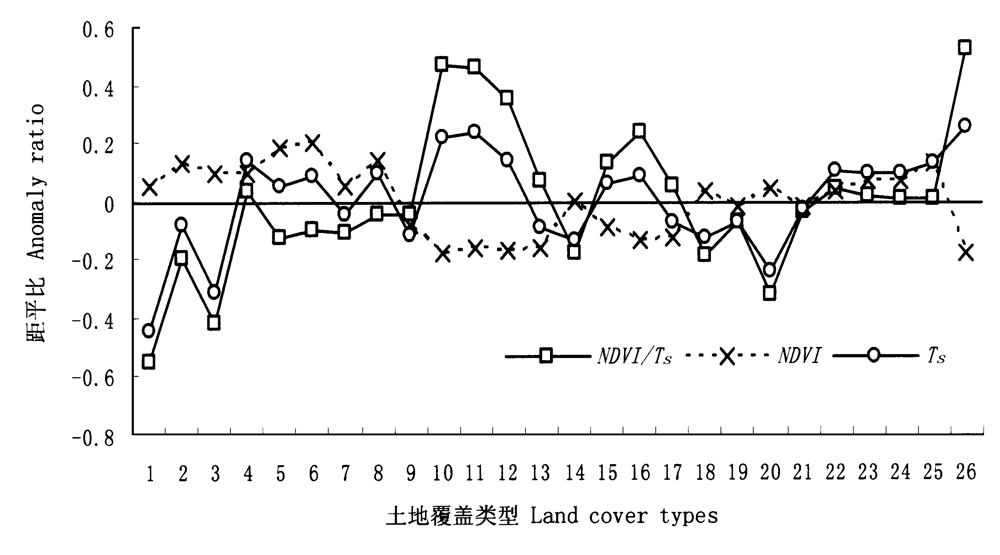
Fig.3 Anomaly ratios of NDVI,Ts and Ts/NDVI to various land cover types See Table 2
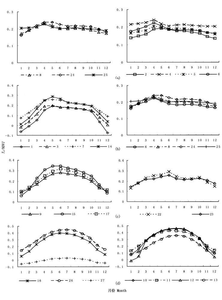
Fig.4 The seasonal variation curves of Ts/NDVI to various land cover categories See Table 2
| 分类指标 Index for classification | GPS取样区 Sampling area for GPS spots | 总点数 Number of total spots | 正确点 Number of correct | 错(混)分点 Number of incongruous (mixed) | 精度 Accuracy(%) |
|---|---|---|---|---|---|
| Ts/NDVI | 海南地区 Hainan region | 79 | 50 | 29 | 63.3 |
| 内蒙古地区 Inner Mongolia region | 219 | 163 | 56 | 74.4 | |
| 新疆地区 Xinjiang region | 282 | 201 | 81 | 71.3 | |
| 东北地区 Northeast region | 87 | 66 | 21 | 75.9 | |
| 整个研究区 The whole study region | 667 | 480 | 187 | 72.0 | |
| NDVI | 海南地区 Hainan region | 79 | 54 | 25 | 68.4 |
| 内蒙古地区 Inner Mongolia region | 219 | 152 | 67 | 69.4 | |
| 新疆地区 Xinjiang region | 282 | 192 | 90 | 68.1 | |
| 东北地区 Northeast region | 87 | 60 | 27 | 69.0 | |
| 整个研究区 The whole study region | 667 | 458 | 209 | 68.7 |
Table 3 Field spot check list of classification
| 分类指标 Index for classification | GPS取样区 Sampling area for GPS spots | 总点数 Number of total spots | 正确点 Number of correct | 错(混)分点 Number of incongruous (mixed) | 精度 Accuracy(%) |
|---|---|---|---|---|---|
| Ts/NDVI | 海南地区 Hainan region | 79 | 50 | 29 | 63.3 |
| 内蒙古地区 Inner Mongolia region | 219 | 163 | 56 | 74.4 | |
| 新疆地区 Xinjiang region | 282 | 201 | 81 | 71.3 | |
| 东北地区 Northeast region | 87 | 66 | 21 | 75.9 | |
| 整个研究区 The whole study region | 667 | 480 | 187 | 72.0 | |
| NDVI | 海南地区 Hainan region | 79 | 54 | 25 | 68.4 |
| 内蒙古地区 Inner Mongolia region | 219 | 152 | 67 | 69.4 | |
| 新疆地区 Xinjiang region | 282 | 192 | 90 | 68.1 | |
| 东北地区 Northeast region | 87 | 60 | 27 | 69.0 | |
| 整个研究区 The whole study region | 667 | 458 | 209 | 68.7 |
| [1] | Becker F, Li ZL (1990). Towards a local split window method over land surface. International Journal of Remote Sensing, 11,369-393. |
| [2] | Carpenter GA, Gjaja MN, Gopal S, Woodcock CE (1997). ART neural networks for remote sensing: vegetation classification from Landsat TM and terrain data. IEEE Transactions on Geoscience and Remote Sensing, 35,308-325. |
| [3] | Chen YH (陈云浩), Li XB (李晓兵), Shi PJ (史培军), Dou W (窦闻), Li X (李霞) (2003). Intra-annual vegetation change characteristics in the NDVI-T s space application to Farming-Pastoral Zone in North China. Acta Botanica Sinica (植物学报), 45,1139-1145. (in Chinese with English abstract) |
| [4] | Cihlar J, Xiao QH, Chen J, Beaubien J, Fung K, Latifovic R (1998). Classification by progressive generalization: a new automated methodology for remote sensing multichannel data. International Journal of Remote Sensing, 19,2685-2704. |
| [5] | Du MY (杜明义), Wu WB (武文波), Guo DZ (郭达志) (2002). Research on multi-source geographic information based classification of desertification. Journal of Image and Graphics (中国图象图形学报), 7,740-743. (in Chinese with English abstract) |
| [6] | Ehrlich D, Estes JE, Singh A (1994). Applications of NOAA-AVHRR 1 km data for environmental monitoring. International Journal of Remote Sensing, 15,145-161. |
| [7] | Foody GM (1998). Sharpening fuzzy classification output to refine the representation of sub-pixel land cover distribution. International Journal of Remote Sensing, 19,2593-2599. |
| [8] | Hansen M, Dubayah R, DeFries R (1996). Classification trees: an alternative to traditional land cover classifiers. International Journal of Remote Sensing, 17,1075-1081. |
| [9] | Holben BN (1986). Characteristics of maximum-value composite images for temporal AVHRR data. International Journal of Remote Sensing, 7,1435-1445. |
| [10] | Josef C, Ly H, Li QZ, Chen J, Hartely P, Huang FT (1997). Multitemporal, mulitichannel AVHRR data sets for land biosphere studies-artifacts and corrections. Remote Sensing of Environment, 60,35-57. |
| [11] | Lambin EF, Ehrlich D (1995). Combing vegetation indices and surface temperature for land-cover mapping at broad spatial scales. International Journal of Remote Sensing, 16,573-579. |
| [12] | Lambin EF, Ehrlich D (1996). The surface temperature-vegetation index space for land cover and land-cover change analysis. International Journal of Remote Sensing, 17,463-487. |
| [13] | Lambin EF, Ehrlich D (1997). Land-cover change in Sub-Saharan Africa (1982-1991): application of a change index based on remotely sensed surface temperature and vegetation indices at a continental scale. Remote Sensing of Environment, 61,181-200. |
| [14] | Land Processes Distributed Active Archive Center LPDAAC (2004). Global land cover characterization database. http://edcdaac.usgs.gov/glcc/.Cited 20 Jun 2004. |
| [15] | Lark RM (1995). A reappraisal of unsupervised classification Ⅱ. Optimal adjustment of the map legend and a neigbourhood approach for mapping legend units. International Journal of Remote Sensing, 16,1445-1460. |
| [16] | Li DF (李道峰), Tian Y (田英), Hao FH (郝芳华) (2003). NDVI data based study on complex classification of vegetation cover of Yellow River Basin. Research of Soil and Water Conservation (水土保持研究), 10,88-91. (in Chinese with English abstract) |
| [17] | Li XB (李晓兵), Chen YH (陈云浩), Yu F (喻锋) (2004). Global and regional cover mapping from remote sensing data: status quo, strategies and trends. Advance in Earth Sciences, 19(1),71-80. (in Chinese with English abstract) |
| [18] | Loveland TR, Merchant JW, Ohlen DO, Brown J (1991). Development of a land-cover database for the conterminous U.S. Photogrammetric Engineering and Remote Sensing, 57,1453-1463. |
| [19] | Meer F (1995). Spectral unmixing of landsat the matci mapper data. International Journal of Remote Sensing, 16,3189-3194. |
| [20] | NASA. Pathfinder Advanced Very High Resolution Radiometer(AVHRR) Land FTP Data (2004). http://daac.gsfc.nasa.gov/. Cited 20 Jun 2004. |
| [21] | Pan YZ (潘耀忠), Li XB (李晓兵), He CY (何春阳) (2000). Research on comprehensive land cover classification in China: Based on NOAA/AVHRR and Holdridge PE index. Quaternary Sciences (第四纪研究), 20,270-281. (in Chinese with English abstract) |
| [22] | Qin ZH (覃志豪), Arnon K (2001). Split window algorithms for retrieving land surface temperature from NOAA-AVHRR data. Remote Sensing for Land & Resources (国土资源遥感), 2,33-42. (in Chinese with English abstract) |
| [23] | Running SW, Loveland TR, Pierce LL, Nemani RR, Hunt ER (1995). A remote sensing based vegetation classification logic for global land cover analysis. Remote Sensing of Environment, 51,39-48. |
| [24] | Saunders RW, Kriebel KT (1988). An improved method for detecting clear sky and cloudy radiances from AVHRR data. International Journal of Remote Sensing, 9,123-150. |
| [25] | Townshend JR, Justice CO, Kalb V (1987). Characterization and classification of South American land cover types using satellite data. International Journal of Remote Sensing, 8,1189-1207. |
| [26] |
Tucker CJ, Townshend JR, Goff TE (1985). African land-cover classification using satellite data. Science, 227,369-375.
URL PMID |
| [27] | Wu ZY (吴征缢) (1980). Vegetation of China (中国植被). Science Press, Beijing. (in Chinese) |
| [28] | Yan H (延昊), Wang CY (王长耀), Niu Z (牛铮), Jiang XG (姜小光), Wang W (王汶) (2001). Bio-implication of Principal Component Analysis to land cover using multitemporal AVHRR data. Remote Sensing Technology and Application (遥感技术与应用), 16,209-213. (in Chinese with English abstract) |
| [29] | Yang ZY (杨正宇), Zhou GS (周广胜), Yang DA (杨奠安) (2003). Comparison of simulated vegetation distribution in China produced by four popular climate-vegetation classification models. Acta Phytoecologica Sinica (植物生态学报), 27,587-593. (in Chinese with English abstract) |
| Viewed | ||||||
|
Full text |
|
|||||
|
Abstract |
|
|||||
Copyright © 2022 Chinese Journal of Plant Ecology
Tel: 010-62836134, 62836138, E-mail: apes@ibcas.ac.cn, cjpe@ibcas.ac.cn