
Chin J Plant Ecol ›› 2016, Vol. 40 ›› Issue (10): 969-979.DOI: 10.17521/cjpe.2016.0101
Special Issue: 生态遥感及应用
• Research Articles • Next Articles
Tao-Yu LIU1, Xia ZHAO1,*( ), Hai-Hua SHEN1, Hui-Feng HU1, Wen-Jiang HUANG2, Jing-Yun FANG1
Online:2016-10-10
Published:2016-11-02
Contact:
Xia ZHAO
Tao-Yu LIU, Xia ZHAO, Hai-Hua SHEN, Hui-Feng HU, Wen-Jiang HUANG, Jing-Yun FANG. Spectral feature differences between shrub and grass communities and shrub coverage retri- eval in shrub-encroached grassland in Xianghuang Banner, Nei Mongol, China[J]. Chin J Plant Ecol, 2016, 40(10): 969-979.
Add to citation manager EndNote|Ris|BibTeX
URL: https://www.plant-ecology.com/EN/10.17521/cjpe.2016.0101
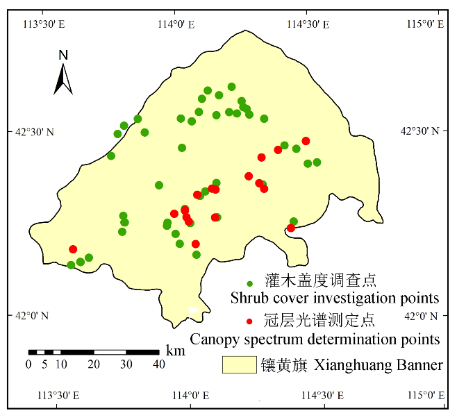
Fig. 1 Geographic location of study area and the distributions of field sampling.
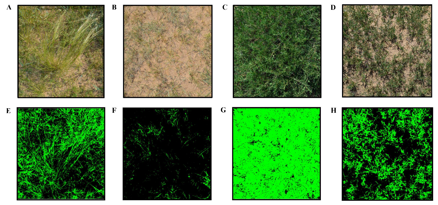
Fig. 2 Photos of 1 m × 1 m sampling plots and the auto-extracted pictures of vegetation coverage. A, Grass sample plot with a 34% vegetation coverage. B, Grass sample plot with a 34% vegetation coverage. C, Shrub sample plot with a 91% vegetation coverage. D, Shrub sample plot with a 32% vegetation coverage. E, F, G, H the vegetation coverage of A, B, C, D retrieved by the software, respectively (Vegetation coverage was colored green).

Fig. 3 Spectral features of different vegetation coverage between the shrub and grass communities. A, Spectra of Leymus chinensis with different vegetation coverage. B, Spectra of Stipa krylovii with different vegetation coverage. C, Spectra of Caragana microphylla with different vegetation coverage. D, Comparison of dominant shrub and grass communities’ spectra.
| 1 m × 1 m小样方植被覆盖度 Vegetation cover within 1 m × 1 m plot | 羊草 Leymus chinensis | 克氏针茅 Stipa krylovii | |||||
|---|---|---|---|---|---|---|---|
| mNDVI705 | REP | NDVI | mNDVI705 | REP | NDVI | ||
| <10% | 0.17 ± 0.01 | 705.22 ± 1.46 | 0.24 ± 0.02 | 0.19 ± 0.04 | 704.65 ± 4.20 | 0.26 ± 0.05 | |
| 10%-20% | - | - | - | 0.23 ± 0.03 | 702.81 ± 2.52 | 0.33 ± 0.06 | |
| 20%-35% | 0.35 ± 0.02 | 708.45 ± 2.32 | 0.49 ± 0.05 | 0.27 ± 0.04 | 702.62 ± 1.29 | 0.40 ± 0.06 | |
Table 1 Changes in spectral features with shrub and grass dominancy and vegetation coverage (mean ± SD)
| 1 m × 1 m小样方植被覆盖度 Vegetation cover within 1 m × 1 m plot | 羊草 Leymus chinensis | 克氏针茅 Stipa krylovii | |||||
|---|---|---|---|---|---|---|---|
| mNDVI705 | REP | NDVI | mNDVI705 | REP | NDVI | ||
| <10% | 0.17 ± 0.01 | 705.22 ± 1.46 | 0.24 ± 0.02 | 0.19 ± 0.04 | 704.65 ± 4.20 | 0.26 ± 0.05 | |
| 10%-20% | - | - | - | 0.23 ± 0.03 | 702.81 ± 2.52 | 0.33 ± 0.06 | |
| 20%-35% | 0.35 ± 0.02 | 708.45 ± 2.32 | 0.49 ± 0.05 | 0.27 ± 0.04 | 702.62 ± 1.29 | 0.40 ± 0.06 | |
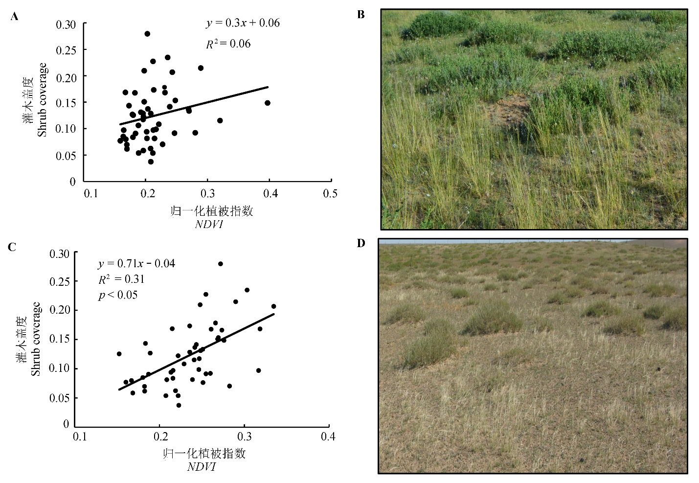
Fig. 4 Linear models based on multi-temporal images and landscape of shrub-encroached grassland in different seasons. A, Linear model in the mid-summer. B, Landscape of shrub-encroached grassland in mid-summer. C, Linear model in early autumn. D, Landscape of shrub-encroached grassland in early autumn. NDVI, normalized difference vegetation index.
| 1 m × 1 m小样方植被覆盖度 Vegetation coverage within 1 m × 1 m plot | 小叶锦鸡儿 Caragana microphylla | ||
|---|---|---|---|
| mNDVI705 | REP | NDVI | |
| 35%-50% | 0.41 ± 0.06 | 716.15 ± 2.69 | 0.49 ± 0.07 |
| 50%-70% | 0.51 ± 0.04 | 718.78 ± 2.63 | 0.63 ± 0.08 |
| 70%-90% | 0.62 ± 0.09 | 722.94 ± 5.06 | 0.77 ± 0.11 |
Table 2 Spectral features of Caragana microphylla by vegetation coverage (mean ± SD)
| 1 m × 1 m小样方植被覆盖度 Vegetation coverage within 1 m × 1 m plot | 小叶锦鸡儿 Caragana microphylla | ||
|---|---|---|---|
| mNDVI705 | REP | NDVI | |
| 35%-50% | 0.41 ± 0.06 | 716.15 ± 2.69 | 0.49 ± 0.07 |
| 50%-70% | 0.51 ± 0.04 | 718.78 ± 2.63 | 0.63 ± 0.08 |
| 70%-90% | 0.62 ± 0.09 | 722.94 ± 5.06 | 0.77 ± 0.11 |
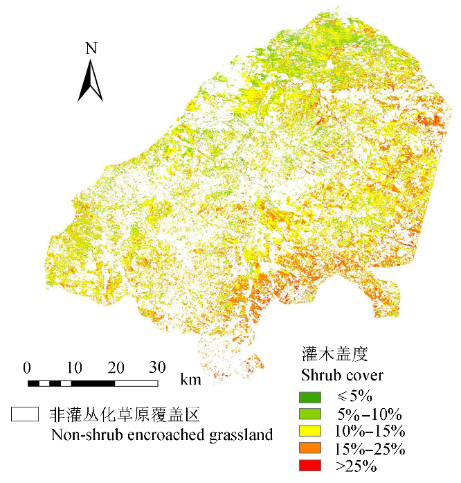
Fig. 5 Predicted shrub coverage based on the linear model in shrub encroached grassland area in Xianghuang Banner.
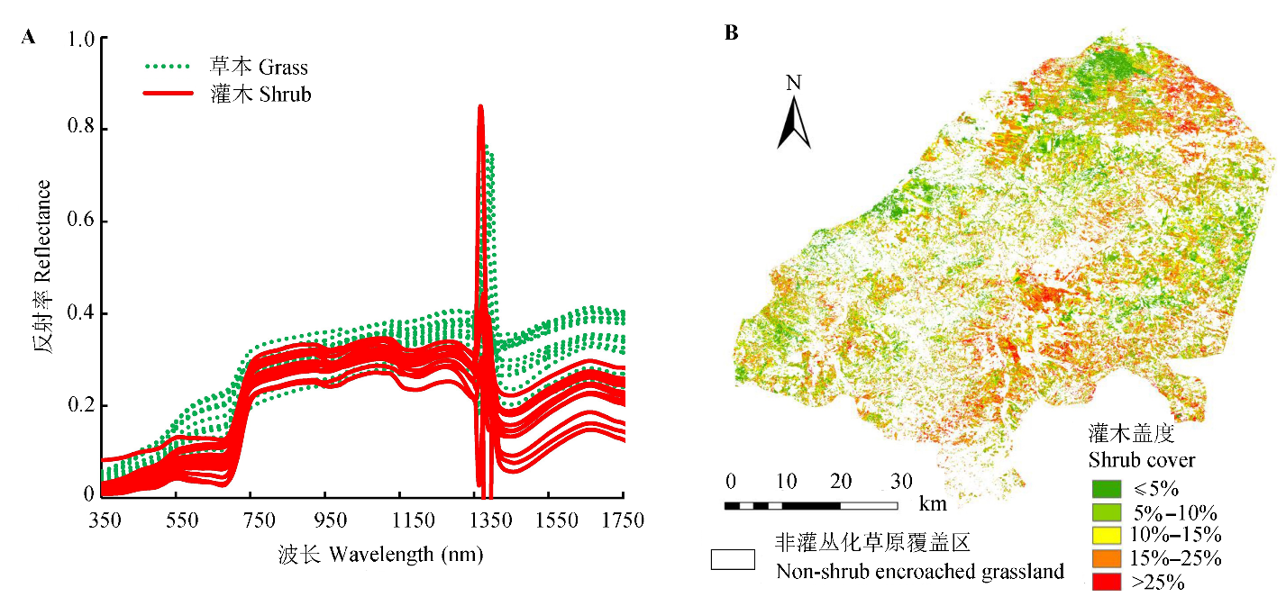
Fig. 6 Endmember spectra of MESMA model and predicted shrub coverage in shrub-encroached grassland area in Xianghuang Banner. A, Endmember spectra in MESMA model. B, Shrub coverage distribution in shrub-encroached grassland in Xianghuang Banner.
| [1] | Adams JB, Sabol DE, Kapos V, Almeida Filho RA, Roberts DA, Smith MO, Gillespie AR (1995). Classification of multispectral images based on fractions of endmembers: Application to land-cover change in the Brazilian Amazon.Remote Sensing of Environment, 52, 137-154. |
| [2] | Archer S, Scifres C, Bassham CR, Maggio R (1988). Autogenic succession in a subtropical savanna: Conversion of grassland to thorn woodland.Ecological Monographs, 58, 111-127. |
| [3] | Asner GP (1998). Biophysical and biochemical sources of variability in canopy reflectance.Remote Sensing of Environment, 64, 234-253. |
| [4] | Cao C, Chen W, Li G, Jia H, Ji W, Xu M, Gao M, Ni X, Zhao J, Zheng S (2011). The retrieval of shrub fractional cover based on a geometric-optical model in combination with linear spectral mixture analysis.Canadian Journal of Remote Sensing, 37, 348-358. |
| [5] | Castro H, Freitas H (2009). Above-ground biomass and productivity in the Montado: From herbaceous to shrub dominated communities.Journal of Arid Environments, 73, 506-511. |
| [6] | Chen LY, Shen HH, Fang JY (2014). Shrub-encroached grassland: A new vegetation type.Chinese Journal of Nature, 6, 391-396.(in Chinese with English abstract) [陈蕾伊, 沈海花, 方精云 (2014). 灌丛化草原: 一种新的植被景观. 自然杂志, 6, 391-396.] |
| [7] | Chen XQ, Li J (2009). Relationships between Leymus chinensis phenology and meteorological factors in Inner Mongolia grasslands.Acta Ecologica Sinica, 10, 5280-5290.(in Chinese with English abstract)[陈效逑, 李倞 (2009). 内蒙古草原羊草物候与气象因子的关系. 生态学报,10, 5280-5290.] |
| [8] | Cho MA, Skidmore AK (2006). A new technique for extracting the red edge position from hyper-spectral data: The linear extrapolation method.Remote Sensing of Environment, 101, 181-193. |
| [9] | Deng SB, Chen QJ (2010). Spectral Characteristics of Vegeta- tion and Vegetation Index Summary. The Application of Remote Sensing China Association 2010 Conference and Regional Remote Sensing and Industrial Development Forum. China Association of Remote Sensing Application, Beijing. 9.(in Chinese)[邓书斌, 陈秋锦 (2010).植被波谱特征与植被指数综述. 中国遥感应用协会2010年会暨区域遥感发展与产业高层论坛论文集. 中国遥感应用协会, 北京. 9.] |
| [10] | Dong Z, Zhao X, Liang D, Huang WJ, Peng DL, Huang LS (2014). Remote sensing identification of shrub encroach- ment in Xianghuangqi, Nei Mongol.Transactions of the Chinese Society of Agricultural Engineering, 11, 152-158.(in Chinese with English abstract)[董洲, 赵霞, 梁栋, 黄文江, 彭代亮, 黄林生 (2014). 内蒙古灌丛化草原分布特征的遥感辨识. 农业工程学报,11, 152-158.] |
| [11] | Eldridge DJ, Bowker MA, Maestre FT, Roger E, Reynolds JF, Whitford WG (2011). Impacts of shrub encroachment on ecosystem structure and functioning: Towards a global synthesis.Ecology Letters, 14, 709-722. |
| [12] | Elmore AJ, Mustard JF, Manning SJ, Lobell DB (2000). Quantifying vegetation change in semiarid environments.Remote Sensing of Environment, 73, 87-102. |
| [13] | Fan Y, Li XY, Li GY (2014). Variation characteristics of shrub phenology in grassland of Inner Mongolia based on MODIS.Journal of Arid Meteorology, 6, 902-908.(in Chinese with English abstract) [范瑛, 李小雁, 李广泳 (2014).基于遥感数据的内蒙古草原灌丛物候变化研究. 干旱气象,6, 902-908.] |
| [14] | Goslee SC, Havstad KM, Peters DC, Rango A, Schlesinger WH (2003). High-resolution images reveal rate and pattern of shrub encroachment over six decades in New Mexico, USA.Journal of Arid Environments, 54, 755-767. |
| [15] | Hamada Y, Stow DA, Roberts DA, Franklin J, Kyriakidis PC (2013). Assessing and monitoring semi-arid shrublands using object-based image analysis and multiple endmember spectral mixture analysis.Environmental Monitoring and Assessment, 185, 3173-3190. |
| [16] | Hostert P, Roder A, Hill J (2003). Coupling spectral unmixing and trend analysis for monitoring of long-term vegetation dynamics in Mediterranean rangelands.Remote Sensing of Environment, 87, 183-197. |
| [17] | Jurena PN, Archer S (2003). Woody plant establishment and spatial heterogeneity in grasslands.Ecology, 84, 907-919. |
| [18] | Kuemmerle T, Roder A, Hill J (2006). Separating grassland and shrub vegetation by multidate pixel-adaptive spectral mixture analysis.International Journal of Remote Sensing, 27, 3251-3271. |
| [19] | Laliberte AS, Rango A, Havstad KM, Paris JF, Beck RF, Mcneely R, Gonzalez AL (2004). Object-oriented image analysis for mapping shrub encroachment from 1937 to 2003 in southern New Mexico.Remote Sensing of Environment, 93, 198-210. |
| [20] | Mcpherson GR, Wright HA, Wester DB (1988). Patterns of shrub invasion in semiarid Texas grasslands.The American Midland Naturalist, 120, 391-397. |
| [21] | Myint SW, Gober P, Brazel A, Grossman-Clarke S, Weng Q (2011). Per-pixel vs. object-based classification of urban land cover extraction using high spatial resolution im- agery.Remote Sensing of Environment, 115, 1145-1161. |
| [22] | Niu XW (1998). Biological characteristics of Caragana microphylla.Acta Agriculturae Boreali-Sinica, 4, 123-130.(in Chinese with English abstract)[牛西午 (1998). 柠条生物学特性研究. 华北农学报,4, 123-130.] |
| [23] | Peng HY, Li XY, Tong SY (2014). Advance in shrub en- croachment in arid and semiarid region. Acta Prataculturae Sinica, 23, 313-322.(in Chinese with English abstract)[彭海英, 李小雁, 童绍玉 (2014). 干旱半干旱区草原灌丛化研究进展. 草业学报,23, 313-322.] |
| [24] | Roberts DA, Gardner M, Church R, Ustin S, Scheer G, Green RO (1998). Mapping chaparral in the Santa Monica Mountains using multiple endmember spectral mixture models.Remote Sensing of Environment, 65, 267-279. |
| [25] | Shan LY (2004). Spectrum Analysis and Information Obtaining on TM Image of Xianghuang Banner Grassland in Inner Mongolia. Master degree dissertation, Gansu Agricultural University, Lanzhou. 4-9.(in Chinese with English abstract)[单丽燕 (2004). 内蒙古镶黄旗草原TM影像的波谱分析及信息提取. 硕士学位论文, 甘肃农业大学, 兰州. 4-9.] |
| [26] | Shi GH (2014). Effects of climate change on phenophase of forage grass in Xilinguole typical grassland.Chinese Agricultural Science Bulletin, 29, 197-204.(in Chinese with English abstract)[师桂花 (2014). 气候变化对锡林郭勒盟典型草原天然牧草物候期的影响. 中国农学通报,29, 197-204.] |
| [27] | Smith MO, Ustin SL, Adams JB, Gillespie AR (1990). Vegeta- tion in deserts: I. A regional measure of abundance from multispectral images.Remote Sensing of Environment, 31, 1-26. |
| [28] | Sohn Y, Mccoy RM (1997). Mapping desert shrub rangeland using spectral unmixing and modeling spectral mixtures with TM data.Photogrammetric Engineering and Remote Sensing, 63, 707-716. |
| [29] | Wang H, Li XB, Long HL, Xu X, Zhang C (2008). Simulating vegetation fractional coverage for temperate grassland in Northern China combining NDVI with precipitation time series from 1982 to 1999.Journal of Basic Science and Engineering, 4, 525-536.(in Chinese with English abstract)[王宏, 李晓兵, 龙慧灵, 许旭, 张程 (2008). 整合1982-1999年NDVI与降雨量时间序列模拟中国北方温带草原植被盖度. 应用基础与工程科学学报,4, 525-536.] |
| [30] | Woebbecke DM, Meyer GE, von Bargen K, Mortensen DA (1992). Plant species identification, size, and enumeration using machine vision techniques on near-binary images.SPIE Optics in Agriculture and Forestry, 1836, 208-212. |
| [31] | Xiao J, Moody A (2005). A comparison of methods for estima- ting fractional green vegetation cover within a desert-to- upland transition zone in central New Mexico, USA.Remote Sensing of Environment, 98, 237-250. |
| [32] | Xu N, Ding JL, Liu HX (2012). Extraction of vegetation information in arid area based on NDVI and LSMM: A case study of Turpan.Geomatics & Spatial Information Technology, 7, 52-57.(in Chinese with English abstract)[徐娜, 丁建丽, 刘海霞 (2012). 基于NDVI和LSMM的干旱区植被信息提取研究——以新疆吐鲁番市为例. 测绘与空间地理信息,7, 52-57.] |
| [33] | Zhang FH, Huang MX, Zhang J, Bao G, Bao YH (2014). Identification of grass species based on hyperspectrum—A case study of Xilin Gol Grassland. Bulletin of Surveying and Mapping, (7), 66-69.(in Chinese with English abstract)[张富华, 黄明祥, 张晶, 包钢, 包玉海 (2014). 利用高光谱识别草地种类的研究——以锡林郭勒草原为例. 测绘通报, (7), 66-69.] |
| [34] | Zhou Y, Chen J, Chen XH, Cao X, Zhu XL (2013). Two important indicators with potential to identify Caragana microphylla in Xilin Gol grassland from temporal MODIS data.Ecological Indicators, 34, 520-527. |
| [1] | ZHANG Qi, FENG Ke, CHANG Zhi-Hui, HE Shuang-Hui, XU Wei-Qi. Effects of shrub encroachment on plant and soil microbial in the forest-grassland ecotone [J]. Chin J Plant Ecol, 2023, 47(6): 770-781. |
| [2] | HAO Qing, HUANG Chang. A review of forest aboveground biomass estimation based on remote sensing data [J]. Chin J Plant Ecol, 2023, 47(10): 1356-1374. |
| [3] | CONG Nan, ZHANG Yang-Jian, ZHU Jun-Tao. Temperature sensitivity of vegetation phenology in spring in mid- to high-latitude regions of Northern Hemisphere during the recent three decades [J]. Chin J Plant Ecol, 2022, 46(2): 125-135. |
| [4] | JIANG Yan, CHEN Xing-Fang, YANG Xu-Jie. Changes of aquatic plants in Donghu Lake of Wuhan based 1990-2020 Landsat images [J]. Chin J Plant Ecol, 2022, 46(12): 1551-1561. |
| [5] | TIAN Jia-Yu, WANG Bin, ZHANG Zhi-Ming, LIN Lu-Xiang. Application of spectral diversity in plant diversity monitoring and assessment [J]. Chin J Plant Ecol, 2022, 46(10): 1129-1150. |
| [6] | YAN Zheng-Bing, LIU Shu-Wen, WU Jin. Hyperspectral remote sensing of plant functional traits: monitoring techniques and future advances [J]. Chin J Plant Ecol, 2022, 46(10): 1151-1166. |
| [7] | CHEN Zhe, WANG Hao, WANG Jin-Zhou, SHI Hui-Jin, LIU Hui-Ying, HE Jin-Sheng. Estimation on seasonal dynamics of alpine grassland aboveground biomass using phenology camera-derived NDVI [J]. Chin J Plant Ecol, 2021, 45(5): 487-495. |
| [8] | GUO Qing-Hua, HU Tian-Yu, MA Qin, XU Ke-Xin, YANG Qiu-Li, SUN Qian-Hui, LI Yu-Mei, SU Yan-Jun. Advances for the new remote sensing technology in ecosystem ecology research [J]. Chin J Plant Ecol, 2020, 44(4): 418-435. |
| [9] | DING Wei,WANG Yu-Bing,XIANG Guan-Hai,CHI Yong-Gang,LU Shun-Bao,ZHENG Shu-Xia. Effects of Caragana microphylla encroachment on community structure and ecosystem function of a typical steppe [J]. Chin J Plant Ecol, 2020, 44(1): 33-43. |
| [10] | ZHANG Xue-Jiao, GAO Xian-Ming, JI Cheng-Jun, KANG Mu-Yi, WANG Ren-Qing, YUE Ming, ZHANG Feng, TANG Zhi-Yao. Response of abundance distribution of five species of Quercus to climate change in northern China [J]. Chin J Plant Ecol, 2019, 43(9): 774-782. |
| [11] | ZHANG Fu-Guang, ZENG Biao, YANG Tai-Bao. Spatiotemporal distribution changes in alpine desert belt in Qilian Mountains under climate changes in past 30 years [J]. Chin J Plant Ecol, 2019, 43(4): 305-319. |
| [12] | XUE Jing-Yue, WANG Li-Hua, XIE Yu, GAO Jing, HE Jun-Dong, WU Yan. Effect of shrub coverage on grassland ecosystem carbon pool in southwestern China [J]. Chin J Plant Ecol, 2019, 43(4): 365-373. |
| [13] | ZHANG Feng,ZHOU Guang-Sheng. Research progress on monitoring vegetation water content by using hyperspectral remote sensing [J]. Chin J Plan Ecolo, 2018, 42(5): 517-525. |
| [14] | Ke-Qing WANG, He-Song WANG, Osbert Jianxin SUN. Application and comparison of remote sensing GPP models with multi-site data in China [J]. Chin J Plant Ecol, 2017, 41(3): 337-347. |
| [15] | Qi-Dan WANG, Wen-Xin YANG, Jie-Yu HUANG, Kun XU, Pei WANG. Shrub encroachment effect on the evapotranspiration and its component—A numerical simulation study of a shrub encroachment grassland in Nei Mongol, China [J]. Chin J Plant Ecol, 2017, 41(3): 348-358. |
| Viewed | ||||||
|
Full text |
|
|||||
|
Abstract |
|
|||||
Copyright © 2026 Chinese Journal of Plant Ecology
Tel: 010-62836134, 62836138, E-mail: apes@ibcas.ac.cn, cjpe@ibcas.ac.cn
![]()