
Chin J Plant Ecol ›› 2009, Vol. 33 ›› Issue (2): 237-245.DOI: 10.3773/j.issn.1005-264x.2009.02.001
• Research Articles • Next Articles
WU Da-Qian1, LIU Jian2, WANG Wei1, DING Wen-Juan1, WANG Ren-Qing1,2,*( )
)
Received:2008-04-11
Accepted:2008-07-25
Online:2009-04-11
Published:2009-03-31
Contact:
WANG Ren-Qing
WU Da-Qian, LIU Jian, WANG Wei, DING Wen-Juan, WANG Ren-Qing. MUTISCALE ANALYSIS OF VEGETATION INDEX AND TOPOGRAPHIC VARIABLES IN THE YELLOW RIVER DELTA OF CHINA[J]. Chin J Plant Ecol, 2009, 33(2): 237-245.
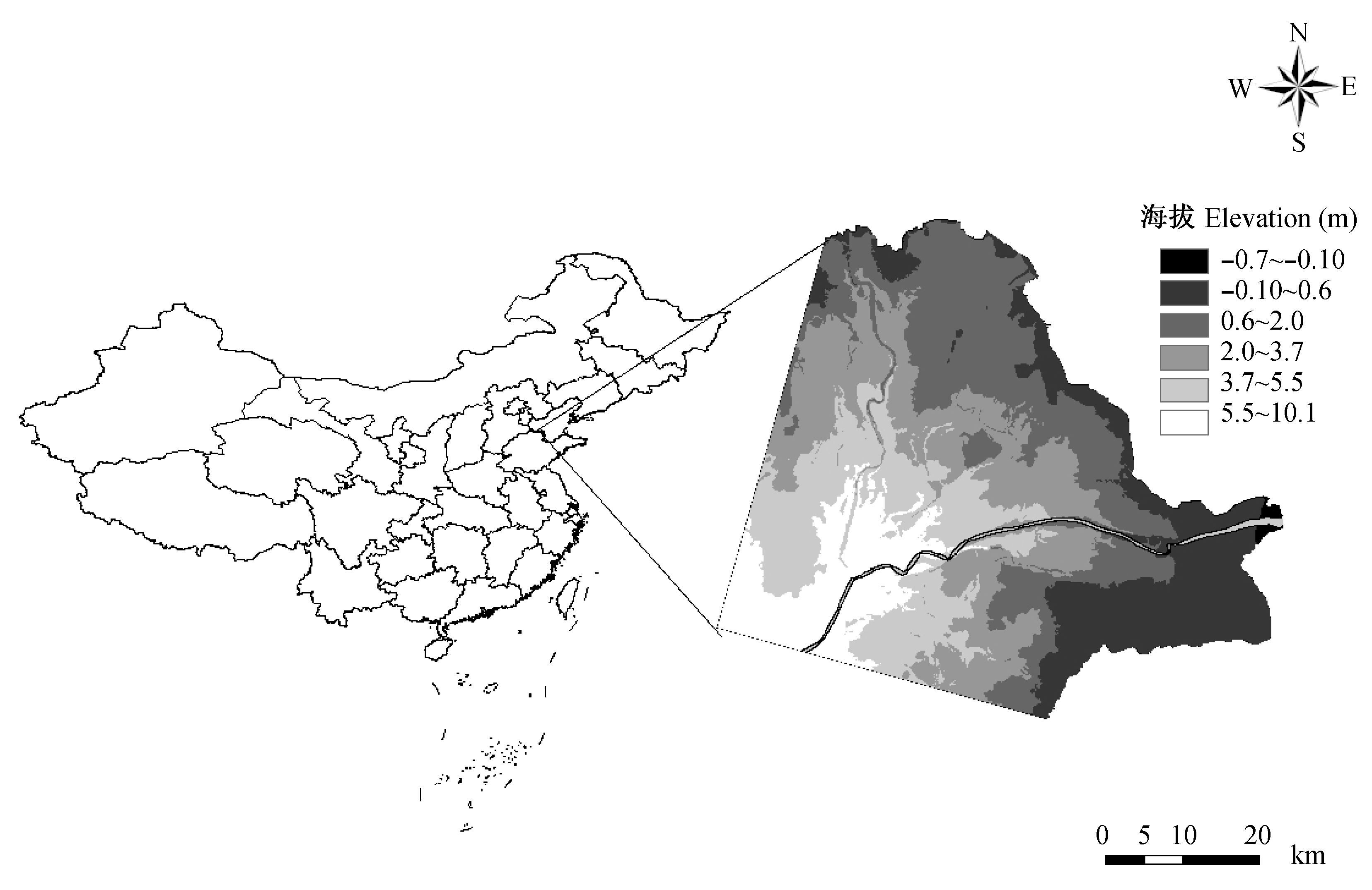
Fig. 1 Location of the Yellow River Delta
| 粒度 Grain | 高程 EL | 坡度 SL | 太阳辐射 SR | 地形湿润度指数 TWI | 南向指数 SI | 东向指数 EI | 距海岸线距离 DC | ||||||||
|---|---|---|---|---|---|---|---|---|---|---|---|---|---|---|---|
| 30 | 0.345*** | -0.037 | 0.095 | 0.049 | -0.013 | -0.003 | 0.332*** | ||||||||
| 90 | 0.316*** | 0.010 | 0.055 | 0.006 | -0.076 | 0.005 | 0.265*** | ||||||||
| 150 | 0.351*** | 0.064 | 0.107* | -0.054 | -0.043 | -0.019 | 0.284*** | ||||||||
| 210 | 0.362*** | 0.059 | 0.127** | -0.066 | 0.018 | -0.061 | 0.297*** | ||||||||
| 300 | 0.370*** | 0.077 | 0.131** | -0.079 | 0.020 | -0.015 | 0.259*** | ||||||||
| 450 | 0.389*** | 0.112* | 0.174*** | -0.095 | 0.081 | -0.067 | 0.312*** | ||||||||
| 600 | 0.438*** | 0.103* | 0.130** | -0.104* | 0.116* | -0.089 | 0.353*** | ||||||||
| 750 | 0.424*** | 0.250*** | 0.140** | -0.245*** | 0.159*** | -0.119** | 0.352*** | ||||||||
| 900 | 0.379*** | 0.172*** | 0.183*** | -0.196*** | 0.173*** | -0.111* | 0.311*** | ||||||||
| 1 050 | 0.411*** | 0.201*** | 0.117** | -0.188*** | 0.108** | -0.107* | 0.346*** | ||||||||
Table 1 Spearman non-parametrical correlation coefficient between NDVI and topographic index at 10 grain scales
| 粒度 Grain | 高程 EL | 坡度 SL | 太阳辐射 SR | 地形湿润度指数 TWI | 南向指数 SI | 东向指数 EI | 距海岸线距离 DC | ||||||||
|---|---|---|---|---|---|---|---|---|---|---|---|---|---|---|---|
| 30 | 0.345*** | -0.037 | 0.095 | 0.049 | -0.013 | -0.003 | 0.332*** | ||||||||
| 90 | 0.316*** | 0.010 | 0.055 | 0.006 | -0.076 | 0.005 | 0.265*** | ||||||||
| 150 | 0.351*** | 0.064 | 0.107* | -0.054 | -0.043 | -0.019 | 0.284*** | ||||||||
| 210 | 0.362*** | 0.059 | 0.127** | -0.066 | 0.018 | -0.061 | 0.297*** | ||||||||
| 300 | 0.370*** | 0.077 | 0.131** | -0.079 | 0.020 | -0.015 | 0.259*** | ||||||||
| 450 | 0.389*** | 0.112* | 0.174*** | -0.095 | 0.081 | -0.067 | 0.312*** | ||||||||
| 600 | 0.438*** | 0.103* | 0.130** | -0.104* | 0.116* | -0.089 | 0.353*** | ||||||||
| 750 | 0.424*** | 0.250*** | 0.140** | -0.245*** | 0.159*** | -0.119** | 0.352*** | ||||||||
| 900 | 0.379*** | 0.172*** | 0.183*** | -0.196*** | 0.173*** | -0.111* | 0.311*** | ||||||||
| 1 050 | 0.411*** | 0.201*** | 0.117** | -0.188*** | 0.108** | -0.107* | 0.346*** | ||||||||
| 粒度 Grain | 高程 EL | NDVI | 坡度 SL | 太阳辐射 SR | 地形湿润度指数 TWI | 南向指数 SI | 东向指数 EI |
|---|---|---|---|---|---|---|---|
| 30 | 0.893 | 0.313 | 0.151 | 0.186 | 0.101 | 0.094 | 0.089 |
| 90 | 0.908 | 0.360 | 0.117 | 0.247 | 0.013 | 0.036 | 0.075 |
| 150 | 0.913 | 0.390 | 0.170 | 0.173 | 0.019 | 0.028 | 0.021 |
| 210 | 0.916 | 0.432 | 0.215 | 0.266 | 0.093 | 0.035 | 0.100 |
| 300 | 0.916 | 0.468 | 0.228 | 0.232 | 0.093 | 0.050 | 0.039 |
| 450 | 0.923 | 0.423 | 0.300 | 0.276 | 0.113 | 0.102 | 0.128 |
| 600 | 0.925 | 0.545 | 0.233 | 0.199 | 0.013 | 0.017 | -0.027 |
| 750 | 0.932 | 0.519 | 0.460 | 0.413 | 0.330 | 0.326 | 0.279 |
| 900 | 0.931 | 0.479 | 0.398 | 0.333 | 0.261 | 0.281 | 0.258 |
| 1 050 | 0.945 | 0.524 | 0.381 | 0.368 | 0.275 | 0.269 | 0.274 |
Table 2 Moran’s index for NDVI and topographic index at 10 grain scales
| 粒度 Grain | 高程 EL | NDVI | 坡度 SL | 太阳辐射 SR | 地形湿润度指数 TWI | 南向指数 SI | 东向指数 EI |
|---|---|---|---|---|---|---|---|
| 30 | 0.893 | 0.313 | 0.151 | 0.186 | 0.101 | 0.094 | 0.089 |
| 90 | 0.908 | 0.360 | 0.117 | 0.247 | 0.013 | 0.036 | 0.075 |
| 150 | 0.913 | 0.390 | 0.170 | 0.173 | 0.019 | 0.028 | 0.021 |
| 210 | 0.916 | 0.432 | 0.215 | 0.266 | 0.093 | 0.035 | 0.100 |
| 300 | 0.916 | 0.468 | 0.228 | 0.232 | 0.093 | 0.050 | 0.039 |
| 450 | 0.923 | 0.423 | 0.300 | 0.276 | 0.113 | 0.102 | 0.128 |
| 600 | 0.925 | 0.545 | 0.233 | 0.199 | 0.013 | 0.017 | -0.027 |
| 750 | 0.932 | 0.519 | 0.460 | 0.413 | 0.330 | 0.326 | 0.279 |
| 900 | 0.931 | 0.479 | 0.398 | 0.333 | 0.261 | 0.281 | 0.258 |
| 1 050 | 0.945 | 0.524 | 0.381 | 0.368 | 0.275 | 0.269 | 0.274 |
| [1] | Austin MP, Nicholls AO (1988). Species associates within herbaceous vegetation in an Australian Eucalyptus forest. In: During HJ, Werger MJA, Willianms JH eds. Diversity and Pattern in Plant Communities. SPB Academic Publishing, The Hague, 95-114. |
| [2] | Beven KJ, Kirkby MJ (1979). A physically based variable contributing area model of basin hydrology. Hydrological Science Bulletin, 24,43-69. |
| [3] | Cantero JJ, Leon R, Cisneros JM, Cantero A (1998). Habitat structure and vegetation relationships in central Argentina salt marsh landscapes. Plant Ecology, 137,79-100. |
| [4] | Chapman VJ (1974). Salt marshes and salt desert of the world. In: Reinold RJ, Queen WH eds. Ecology of Halophytes. Academic Press, London, 3-19. |
| [5] | Chen JY, Taniguchi M, Liu GQ, Miyaoka K, Onodera S, Tokunaga T, Fukushima Y (2007). Nitrate pollution of groundwater in the Yellow River Delta, China. Hydrogeology Journal, 15,1605-1614. |
| [6] | Chuvieco E, Coccero D, Riaño D, Martin P, Martínez-Vega J, de la Riva, Pérez F (2004). Combining NDVI and surface temperature for the estimation of live fuel moisture content in forest fire danger rating. Remote Sensing of Environment, 92,322-331. |
| [7] | Del Barrio G, Alvera B, Puigdefabregas J, Diez C (1997). Response of high mountain landscape to topographic variables: central pyrenees. Landscape Ecology, 12,95-115. |
| [8] | Deng Y, Chen X, Chuvieco E, Warner T, Wilson JP (2007). Multi-scale linkages between topographic attributes and vegetation indices in a mountainous landscape. Remote Sensing of Environment, 111,122-134. |
| [9] | Dubayah RC (1994). Modeling a solar radiation topoclimatology for the Rio Grande River Basin. Journal of Vegetation Science, 5,627-640. |
| [10] | Emery NC, Ewanchuk PJ, Bertness MD (2001). Competition and salt marsh plant zonation: stress tolerators may be dominant competitors. Ecology, 82,2471-2485. |
| [11] |
Fang HL, Liu GH, Kearney M (2005). Georalational analysis of soil type, soil salt content, topography, and land use in the Yellow River Delta, China. Environmental Management, 35,72-83.
DOI URL PMID |
| [12] | Franklin J (1995). Predictive vegetation mapping: geographic modeling of biospatial patterns in relation to environmental gradients. Progress in Physical Geography, 19,474-499. |
| [13] | Franklin J, Woodcock CE, Warbington R (2000). Digital vegetation maps of forest lands in California: integrating satellite imagery, GIS modeling, and field data in support of resource management. Photogrammetric Engineering and Remote Sensing, 66,1209-1217. |
| [14] | Galle S, Ehrmann M, Peugeot C (1999). Water balance in a banded vegetation pattern - A case study of tiger bush in western Niger. Catena, 37,197-216. |
| [15] | Garcia-Aguirre MC, Ortiz MA, Zamorano JJ, Reyes Y (2007). Vegetation and topography relationships at Ajusco volcano Mexico, using a geographic information system (GIS). Forest Ecology and Management, 239,1-12. |
| [16] | Guan YX(关元秀), Liu GH(刘高焕), Wang JF(王劲峰) (2001). Regionalization of salt-affected land for amelioration in the Yellow River Delta based on GIS. Acta Geographica Sinica (地理学报), 56,198-205. (in Chinese with English abstract) |
| [17] | Hara M, Hirata K, Oono K (1996). Relationship between microlandform and vegetation structure in an evergreen broad-leaved forest on Okinawa Island, SW Japan. Natural History Research, 4,27-35. |
| [18] | Huang XX(黄晓霞), Jiang Y(江源), Liu QR(刘全儒), Huang QR(黄秋如) (2007). Relationship between habitats and communities of subalpine meadow on Mt. Xiaowutai, North China. Journal of Plant Ecology(Chinese Version)(植物生态学报), 31,437-444. (in Chinese with English abstract) |
| [19] | Kühn I (2007). Incorporating spatial autocorrelation may invert observed patterns. Diversity and Distributions, 13,66-69. |
| [20] | Leone AP, Menenti M, Buondonno A, Letizia A, Maffei C, Sorrentino G (2007). A field experiment on spectrometry of crop response to soil salinity. Agricultural Water Management, 89,39-48. |
| [21] | Levins SA (1992). The problem of pattern and scale in ecology. Ecology, 73,1943-1967. |
| [22] | Li H, Wu J (2004). Use and misuse of landscape indices. Landscape Ecology, 19,389-399. |
| [23] | Li XB, Chen YH, Yang H, Zhang YX (2005). Improvement, comparison and application of field measurement methods for grassland vegetation fractional coverage. Journal of Integrative Plant Biology, 47,1074-1083. |
| [24] | Li XD(李兴东) (1993). Canonical analysis and the principal components analysis of plant community with its environmental factors in the Yellow River Delta. Acta Botanica Sinica(植物学报), 35(Suppl.),139-143. (in Chinese with English abstract) |
| [25] | Moore ID, Gessler PE, Nielsen GA, Peterson GA (1993). Soil attribute prediction using terrain analysis. Soil Science Society of America Journal, 57,443-452. |
| [26] | Muñoz-Reinoso JC, Novo FG (2005). Multiscale control of vegetation patterns: the case of Doñana (SW Spain). Landscape Ecology, 20,51-61. |
| [27] | Pan DY, Bouchard A, Legendre P, Domon G (1998). Influence of edaphic factors on the spatial structure of inland halophytic communities: a case study in China. Journal of Vegetation Science, 9,797-804. |
| [28] | Pfeffer K, Pebesma EJ, Burrough PA (2003). Mapping alpine vegetation using vegetation observations and topographic attributes. Landscape Ecology, 18,759-776. |
| [29] | Piernik A (2003). Inland halophilous vegetation as indicator of soil salinity. Basic and Applied Ecology, 4,525-536. |
| [30] | Pinder JE, Kroh GC, White JD, Basham AM (1997). The relationships between vegetation types and topography in Lassen Vocalnic National Park. Plant Ecology, 131,17-29. |
| [31] | Purevdorj TS, Tateishi R, Ishiyama T, Honda Y (1998). Relationships between percent vegetation cover and vegetation indices. International Journal of Remote Sensing, 19,3519-3535. |
| [32] | Qi Y, Wu JG (1996). Effects of changing spatial resolution on the results of landscape pattern analysis using spatial autocorrelation indices. Landscape Ecology, 11,39-49. |
| [33] | Reed RA, Peet RK, Palmer MW, White PS (1993). Scale dependence of vegetation-environment correlations: a case study of a North Carolina piedmont woodland. Journal of Vegetation Science, 4,329-340. |
| [34] | Shen ZH (沈泽昊), Zhang XS (张新时), Jin YX (金义兴) (2000). An analysis of the topographical patterns of the chief wooly species at Dalaoling in the three Gorges Region. Acta Phytoecologica Sinica (植物生态学报), 24,581-587. (in Chinese with English abstract) |
| [35] | Snow AA, Vince SW (1984). Plant zonation in an Alaskan salt marsh. II. An experimental study of the role of edaphic conditions. Journal of Ecology, 72,669-684. |
| [36] | Swanson FJ, Kratz TK, Caine N, Woodmansee RG (1998). Landform effects on ecosystem patterns and processes. BioScience, 38,92-98. |
| [37] | Turner MG (1989). Landscape ecology: the effect of pattern on process. Annual Review of Ecology and Systematics, 20,171-197. |
| [38] | Ungar IA (1967). Vegetation-soil relationships on saline soils in the northern Kansas. American Midland Naturalist, 78,98-120. |
| [39] | Ungar IA, Hogan W, McClelland M (1969). Plant communities of saline soils at Lincoln, Nebraska. American Midland Naturalist, 82,564-577. |
| [40] | Valentin C, d'Herbes JM, Poesen J (1999). Soil and water components of banded vegetation patterns. Catena, 37,1-24. |
| [41] | van de Rijt CWCJ, Hazelhoff L, Blom CWPM (1996). Vegetation zonation in a former tidal area: a vegetation-type response model based on DCA and logistic regression using GIS. Journal of Vegetation Science, 7,505-518. |
| [42] | Wang RQ(王仁卿), Zhang ZG(张治国) (1993). General survey on the vegetation of the Yellow River Delta in China. Journal of Shandong University (山东大学学报), 28(Suppl.),1-7. (in Chinese with English abstract) |
| [43] | Whittaker RH, Niering WA (1975). Vegetation of the Santa Catalina Mountains, Arizona. V. Biomass, production and diversity along an elevational gradient. Ecology, 56,771-790. |
| [44] | Wu XB, Archer SR (2005). Scale-dependent influence of topography-based hydrologic features on patterns of wood plant encroachment in savanna landscapes. Landscape Ecology, 20,733-742. |
| [45] | Wu ZF(吴志芬), Zhao SL(赵善伦), Zhang XL(张学雷) (1994). Studies on interrelation between salt vegetation and soil salinity in the Yellow River Delta. Acta Phytoecologica Sinica(植物生态学报), 18,184-193. (in Chinese with English abstract) |
| [46] | Xin XP(辛晓平), Gao Q(高琼), Li ZQ(李镇清) (1999). Partitioning the spatial and environmental variation of species abundance of alkaline grassland on Songnen plain. Acta Botanica Sinica (植物学报), 41,775-781. (in Chinese with English abstract) |
| [47] | Yao RJ(姚荣江), Yang JS(杨劲松), Liu GM(刘广明) (2006a). Spatial variability of groundwater properties in some typical areas of the Yellow River Delta. Chinese Journal of Soil Science (土壤通报), 37,1071-1075. (in Chinese with English abstract) |
| [48] | Yao RJ(姚荣江), Yang JS(杨劲松), Liu GM(刘广明), Zou P(邹平) (2006b). Spatial variability of soil salinity in characteristic field of the Yellow River Delta. Transactions of the Chinese Society of Agricultural Engineering(农业工程学报), 22(6),61-66. (in Chinese with English abstract) |
| [1] | LI Xue, DONG Jie, HAN Guang-Xuan, ZHANG Qi-Qi, XIE Bao-Hua, LI Pei-Guang, ZHAO Ming-Liang, CHEN Ke-Long, SONG Wei-Min. Response of soil CO2 and CH4 emissions to changes in moisture and salinity at a typical coastal salt marsh of Yellow River Delta [J]. Chin J Plant Ecol, 2023, 47(3): 434-446. |
| [2] | HAO Qing, HUANG Chang. A review of forest aboveground biomass estimation based on remote sensing data [J]. Chin J Plant Ecol, 2023, 47(10): 1356-1374. |
| [3] | CONG Nan, ZHANG Yang-Jian, ZHU Jun-Tao. Temperature sensitivity of vegetation phenology in spring in mid- to high-latitude regions of Northern Hemisphere during the recent three decades [J]. Chin J Plant Ecol, 2022, 46(2): 125-135. |
| [4] | JIANG Yan, CHEN Xing-Fang, YANG Xu-Jie. Changes of aquatic plants in Donghu Lake of Wuhan based 1990-2020 Landsat images [J]. Chin J Plant Ecol, 2022, 46(12): 1551-1561. |
| [5] | TIAN Jia-Yu, WANG Bin, ZHANG Zhi-Ming, LIN Lu-Xiang. Application of spectral diversity in plant diversity monitoring and assessment [J]. Chin J Plant Ecol, 2022, 46(10): 1129-1150. |
| [6] | YAN Zheng-Bing, LIU Shu-Wen, WU Jin. Hyperspectral remote sensing of plant functional traits: monitoring techniques and future advances [J]. Chin J Plant Ecol, 2022, 46(10): 1151-1166. |
| [7] | Ning LIU, Shou-Zhang PENG, Yun-Ming CHEN. Temporal effects of climate factors on vegetation growth on the Qingzang Plateau, China [J]. Chin J Plant Ecol, 2022, 46(1): 18-26. |
| [8] | NI Ming, ZHANG Xi-Yue, JIANG Chao, WANG He-Song. Responses of vegetation to extreme climate events in southwestern China [J]. Chin J Plant Ecol, 2021, 45(6): 626-640. |
| [9] | CHEN Zhe, WANG Hao, WANG Jin-Zhou, SHI Hui-Jin, LIU Hui-Ying, HE Jin-Sheng. Estimation on seasonal dynamics of alpine grassland aboveground biomass using phenology camera-derived NDVI [J]. Chin J Plant Ecol, 2021, 45(5): 487-495. |
| [10] | ZHOU Ming-Xing, LI Deng-Qiu, ZOU Jian-Jun. Vegetation change of giant panda habitats in Qionglai Mountains through dense Landsat Data [J]. Chin J Plant Ecol, 2021, 45(4): 355-369. |
| [11] | XU Guang-Lai, LI Ai-Juan, XU Xiao-Hua, YANG Xian-Cheng, YANG Qiang-Qiang. NDVIdynamics and driving climatic factors in the Protected Zones for Ecological Functions in China [J]. Chin J Plant Ecol, 2021, 45(3): 213-223. |
| [12] | GUO Qing-Hua, HU Tian-Yu, MA Qin, XU Ke-Xin, YANG Qiu-Li, SUN Qian-Hui, LI Yu-Mei, SU Yan-Jun. Advances for the new remote sensing technology in ecosystem ecology research [J]. Chin J Plant Ecol, 2020, 44(4): 418-435. |
| [13] | ZHANG Wen-Qiang, LUO Ge-Ping, ZHENG Hong-Wei, WANG Hao, HAMDI Rafiq, HE Hui-Li, CAI Peng, CHEN Chun-Bo. Analysis of vegetation index changes and driving forces in inland arid areas based on random forest model: a case study of the middle part of northern slope of the north Tianshan Mountains [J]. Chin J Plant Ecol, 2020, 44(11): 1113-1126. |
| [14] | ZHANG Fu-Guang, ZENG Biao, YANG Tai-Bao. Spatiotemporal distribution changes in alpine desert belt in Qilian Mountains under climate changes in past 30 years [J]. Chin J Plant Ecol, 2019, 43(4): 305-319. |
| [15] | ZHANG Feng,ZHOU Guang-Sheng. Research progress on monitoring vegetation water content by using hyperspectral remote sensing [J]. Chin J Plan Ecolo, 2018, 42(5): 517-525. |
| Viewed | ||||||
|
Full text |
|
|||||
|
Abstract |
|
|||||
Copyright © 2022 Chinese Journal of Plant Ecology
Tel: 010-62836134, 62836138, E-mail: apes@ibcas.ac.cn, cjpe@ibcas.ac.cn