
Chin J Plant Ecol ›› 2008, Vol. 32 ›› Issue (5): 1091-1103.DOI: 10.3773/j.issn.1005-264x.2008.05.014 cstr: 32100.14.j.issn.1005-264x.2008.05.014
• Original article • Previous Articles Next Articles
LI Zeng-Jia1,2, MA You-Xin1,*( ), LI Hong-Mei1, PENG Ming-Chun3, LIU Wun-Jun1
Received:2007-11-08
Accepted:2008-05-21
Online:2008-11-08
Published:2008-09-30
Contact:
MA You-Xin
LI Zeng-Jia, MA You-Xin, LI Hong-Mei, PENG Ming-Chun, LIU Wun-Jun. RELATION OF LAND USE AND COVER CHANGE TO TOPOGRAPHY IN XISHUANGBANNA, SOUTHWEST CHINA[J]. Chin J Plant Ecol, 2008, 32(5): 1091-1103.
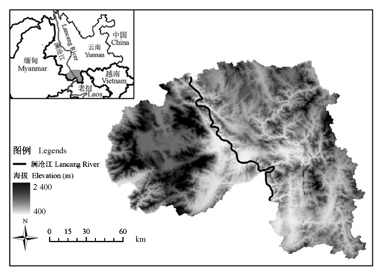
Fig. 1 Location and topography of study area
| 类型 Type | A1 | A2 | A3 | A4 | A5 | A6 | A7 | A8 | A9 | A10 | A11 | Xi+ | UA (%) |
|---|---|---|---|---|---|---|---|---|---|---|---|---|---|
| A1 | 69 | 5 | 1 | 2 | 1 | 78 | 88.5 | ||||||
| A2 | 1 | 27 | 1 | 29 | 93.1 | ||||||||
| A3 | 11 | 43 | 1 | 1 | 2 | 58 | 74.1 | ||||||
| A4 | 1 | 75 | 7 | 83 | 90.4 | ||||||||
| A5 | 1 | 6 | 1 | 8 | 75.0 | ||||||||
| A6 | 1 | 40 | 1 | 42 | 95.2 | ||||||||
| A7 | 1 | 9 | 1 | 11 | 95.2 | ||||||||
| A8 | 1 | 2 | 2 | 31 | 3 | 1 | 40 | 81.8 | |||||
| A9 | 1 | 1 | 25 | 27 | 77.5 | ||||||||
| A10 | 1 | 13 | 14 | 92.9 | |||||||||
| A11 | 2 | 8 | 10 | 80.0 | |||||||||
| X+i | 70 | 49 | 47 | 78 | 9 | 41 | 9 | 42 | 29 | 16 | 10 | OA=86.5 | |
| PA (%) | 98.6 | 55.1 | 91.5 | 96.2 | 66.7 | 97.6 | 100 | 73.8 | 86.2 | 81.3 | 80.0 | ||
Table 1 Error matrix of all land use/cover types in study area
| 类型 Type | A1 | A2 | A3 | A4 | A5 | A6 | A7 | A8 | A9 | A10 | A11 | Xi+ | UA (%) |
|---|---|---|---|---|---|---|---|---|---|---|---|---|---|
| A1 | 69 | 5 | 1 | 2 | 1 | 78 | 88.5 | ||||||
| A2 | 1 | 27 | 1 | 29 | 93.1 | ||||||||
| A3 | 11 | 43 | 1 | 1 | 2 | 58 | 74.1 | ||||||
| A4 | 1 | 75 | 7 | 83 | 90.4 | ||||||||
| A5 | 1 | 6 | 1 | 8 | 75.0 | ||||||||
| A6 | 1 | 40 | 1 | 42 | 95.2 | ||||||||
| A7 | 1 | 9 | 1 | 11 | 95.2 | ||||||||
| A8 | 1 | 2 | 2 | 31 | 3 | 1 | 40 | 81.8 | |||||
| A9 | 1 | 1 | 25 | 27 | 77.5 | ||||||||
| A10 | 1 | 13 | 14 | 92.9 | |||||||||
| A11 | 2 | 8 | 10 | 80.0 | |||||||||
| X+i | 70 | 49 | 47 | 78 | 9 | 41 | 9 | 42 | 29 | 16 | 10 | OA=86.5 | |
| PA (%) | 98.6 | 55.1 | 91.5 | 96.2 | 66.7 | 97.6 | 100 | 73.8 | 86.2 | 81.3 | 80.0 | ||
| 级别 Grade | 海拔 Elevation (m) | 坡度 Slope (°) | 坡向 Aspect |
|---|---|---|---|
| 1 | 400~600 | <5 | 平地 Flat |
| 2 | 600~800 | 5~8 | 北 North |
| 3 | 800~1 000 | 8~15 | 东 East |
| 4 | 1 000~1 200 | 15~25 | 南 South |
| 5 | 1 200~1 400 | 25~35 | 西 West |
| 6 | 1 400~1 600 | >35 | |
| 7 | 1 600~1 800 | ||
| 8 | 1 800~2 000 | ||
| 9 | >2 000 |
Table 2 Classification of different topographic factors
| 级别 Grade | 海拔 Elevation (m) | 坡度 Slope (°) | 坡向 Aspect |
|---|---|---|---|
| 1 | 400~600 | <5 | 平地 Flat |
| 2 | 600~800 | 5~8 | 北 North |
| 3 | 800~1 000 | 8~15 | 东 East |
| 4 | 1 000~1 200 | 15~25 | 南 South |
| 5 | 1 200~1 400 | 25~35 | 西 West |
| 6 | 1 400~1 600 | >35 | |
| 7 | 1 600~1 800 | ||
| 8 | 1 800~2 000 | ||
| 9 | >2 000 |
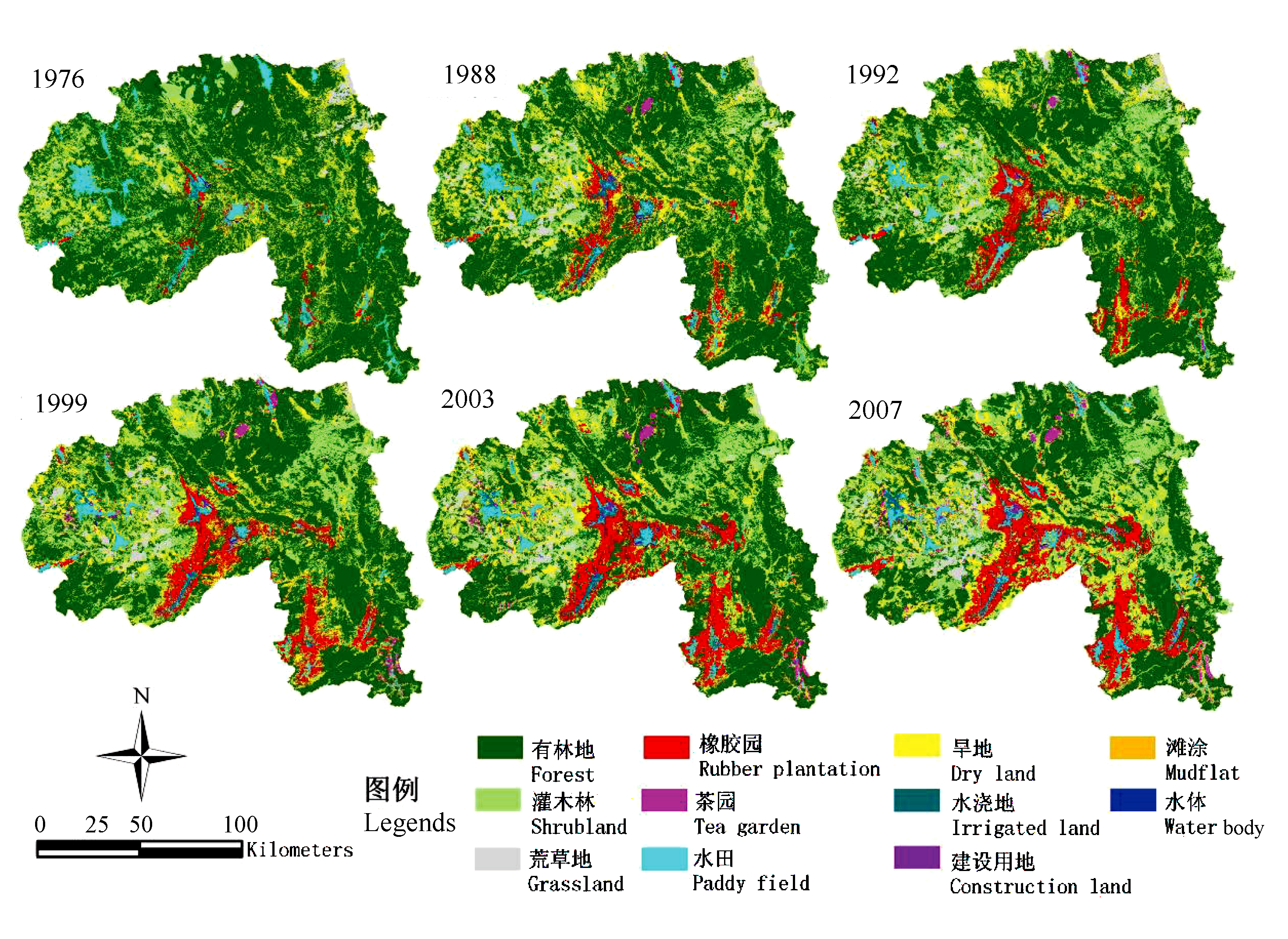
Fig. 2 Land use/cover changes in Xishuangbanna from1976 to 2007
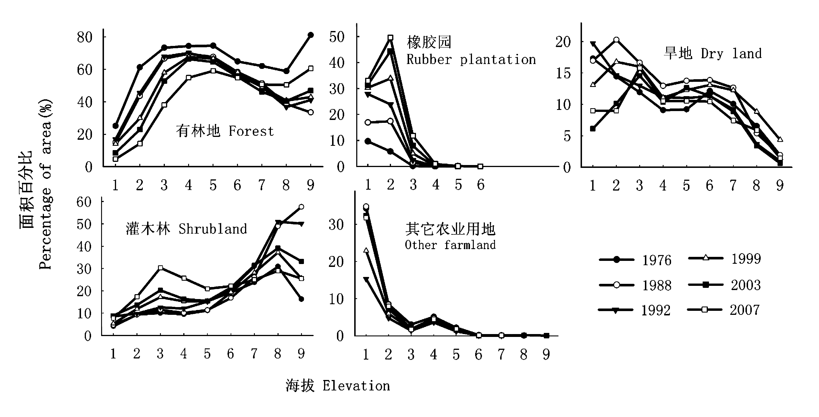
Fig. 3 Area percentage of land use/cover types in different elevation gradients
| 海拔段 Altitude (m) | 总面积 Total area (hm2) | 土地利用/覆盖类型 Land use/cover types | 年变化率 Annual change in percentage (%) | ||||
|---|---|---|---|---|---|---|---|
| 1976~1988 | 1988~1992 | 1992~1999 | 1999~2003 | 2003~2007 | |||
| <600 | 56 162 | 有林地 Forest | -0.85 | 0.49 | -0.39 | -1.38 | -0.95 |
| 灌木林地 Shrubland | 0.05 | 0.95 | -0.43 | 0.85 | -0.28 | ||
| 橡胶园 Rubber plantation | 0.61 | 2.76 | 0.34 | 0.27 | 0.39 | ||
| 农业用地 Farmland | 0.02 | -3.77 | 0.22 | 0.09 | 0.56 | ||
| 建设用地 Construction land | - | 0.04 | 0.26 | 0.24 | 0.14 | ||
| 600~1 000 | 735 674 | 有林地 Forest | -0.94 | 0.37 | -1.76 | -1.48 | -3.04 |
| 灌木林地 Shrubland | 0.06 | 0.22 | 0.50 | 0.63 | 1.86 | ||
| 橡胶园 Rubber plantation | 0.47 | 0.81 | 0.80 | 1.55 | 1.10 | ||
| 农业用地 Farmland | 0.38 | -1.50 | 0.55 | -0.74 | 0.19 | ||
| 建设用地 Construction land | - | 0.05 | 0.00 | 0.02 | 0.00 | ||
| 1 000~1 400 | 820 524 | 有林地 Forest | -0.47 | -0.04 | -0.21 | -0.40 | -2.24 |
| 灌木林地 Shrubland | 0.04 | 0.69 | 0.27 | 0.16 | 1.92 | ||
| 橡胶园 Rubber plantation | 0.00 | 0.00 | 0.01 | 0.01 | 0.11 | ||
| 农业用地 Farmland | 0.34 | -0.76 | 0.19 | 0.16 | 0.27 | ||
| 建设用地 Construction land | - | 0.01 | 0.00 | 0.01 | 0.00 | ||
| >1 400 | 302 905 | 有林地 Forest | -0.84 | -0.41 | 0.18 | -0.59 | 0.56 |
| 灌木林地 Shrubland | 0.18 | 0.92 | -0.49 | 0.63 | -0.68 | ||
| 橡胶园 Rubber plantation | 0.00 | 0.00 | 0.00 | 0.00 | 0.00 | ||
| 农业用地 Farmland | 0.14 | -0.58 | 0.44 | -0.29 | -0.45 | ||
| 建设用地 Construction land | - | 0.01 | 0.00 | 0.00 | 0.00 | ||
Table 3 Annual changes in percentage of land use/cover at various altitude gradients from 1976 to 2007
| 海拔段 Altitude (m) | 总面积 Total area (hm2) | 土地利用/覆盖类型 Land use/cover types | 年变化率 Annual change in percentage (%) | ||||
|---|---|---|---|---|---|---|---|
| 1976~1988 | 1988~1992 | 1992~1999 | 1999~2003 | 2003~2007 | |||
| <600 | 56 162 | 有林地 Forest | -0.85 | 0.49 | -0.39 | -1.38 | -0.95 |
| 灌木林地 Shrubland | 0.05 | 0.95 | -0.43 | 0.85 | -0.28 | ||
| 橡胶园 Rubber plantation | 0.61 | 2.76 | 0.34 | 0.27 | 0.39 | ||
| 农业用地 Farmland | 0.02 | -3.77 | 0.22 | 0.09 | 0.56 | ||
| 建设用地 Construction land | - | 0.04 | 0.26 | 0.24 | 0.14 | ||
| 600~1 000 | 735 674 | 有林地 Forest | -0.94 | 0.37 | -1.76 | -1.48 | -3.04 |
| 灌木林地 Shrubland | 0.06 | 0.22 | 0.50 | 0.63 | 1.86 | ||
| 橡胶园 Rubber plantation | 0.47 | 0.81 | 0.80 | 1.55 | 1.10 | ||
| 农业用地 Farmland | 0.38 | -1.50 | 0.55 | -0.74 | 0.19 | ||
| 建设用地 Construction land | - | 0.05 | 0.00 | 0.02 | 0.00 | ||
| 1 000~1 400 | 820 524 | 有林地 Forest | -0.47 | -0.04 | -0.21 | -0.40 | -2.24 |
| 灌木林地 Shrubland | 0.04 | 0.69 | 0.27 | 0.16 | 1.92 | ||
| 橡胶园 Rubber plantation | 0.00 | 0.00 | 0.01 | 0.01 | 0.11 | ||
| 农业用地 Farmland | 0.34 | -0.76 | 0.19 | 0.16 | 0.27 | ||
| 建设用地 Construction land | - | 0.01 | 0.00 | 0.01 | 0.00 | ||
| >1 400 | 302 905 | 有林地 Forest | -0.84 | -0.41 | 0.18 | -0.59 | 0.56 |
| 灌木林地 Shrubland | 0.18 | 0.92 | -0.49 | 0.63 | -0.68 | ||
| 橡胶园 Rubber plantation | 0.00 | 0.00 | 0.00 | 0.00 | 0.00 | ||
| 农业用地 Farmland | 0.14 | -0.58 | 0.44 | -0.29 | -0.45 | ||
| 建设用地 Construction land | - | 0.01 | 0.00 | 0.00 | 0.00 | ||
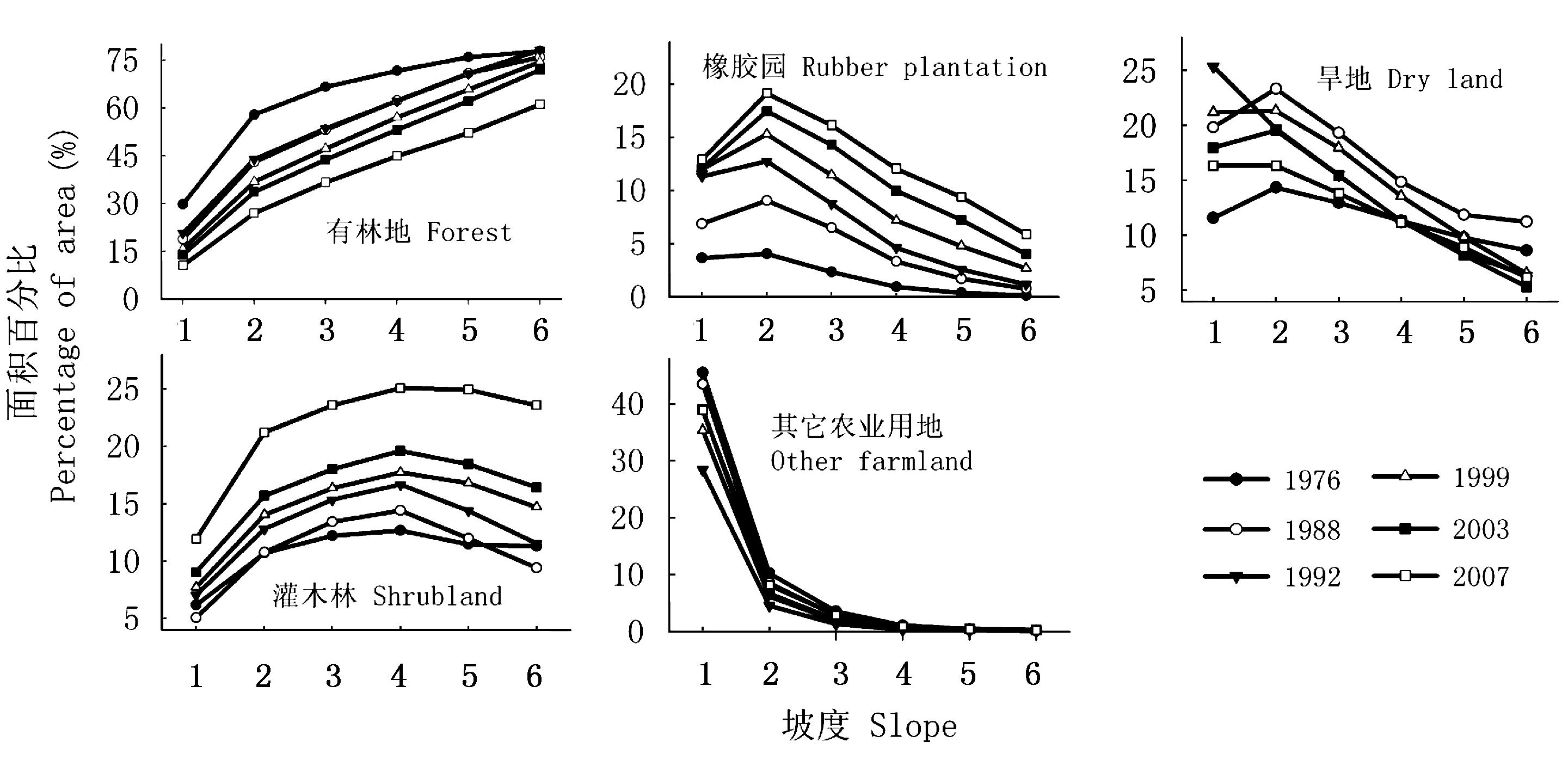
Fig. 4 Area percentage of land use/cover types in different slope gradients
| 坡度 Slope (°) | 总面积 Total area (hm2) | 土地利用/覆盖类型 Land use/cover types | 年变化率 Annual changes in percentage (%) | ||||
|---|---|---|---|---|---|---|---|
| 1976~1988 | 1988~1992 | 1992~1999 | 1999~2003 | 2003~2007 | |||
| <5 | 136 664 | 有林地 Forest | -0.92 | 0.48 | -0.72 | -0.43 | -0.85 |
| 灌木林地 Shrubland | -0.09 | 0.49 | 0.10 | 0.33 | 0.72 | ||
| 橡胶园 Rubber plantation | 0.27 | 1.11 | 0.10 | 0.03 | 0.19 | ||
| 农业用地 Farmland | 0.57 | -2.14 | 0.47 | -0.04 | -0.22 | ||
| 建设用地 Construction land | - | 0.12 | 0.13 | 0.14 | 0.06 | ||
| 5~15 | 347 156 | 有林地 Forest | -1.14 | 0.11 | -0.91 | -0.85 | -1.76 |
| 灌木林地 Shrubland | 0.08 | 0.49 | 0.15 | 0.41 | 1.39 | ||
| 橡胶园 Rubber plantation | 0.36 | 0.64 | 0.38 | 0.68 | 0.45 | ||
| 农业用地 Farmland | 0.54 | -1.35 | 0.54 | -0.32 | 0.00 | ||
| 建设用地 Construction land | 0.01 | 0.04 | 0.01 | 0.01 | 0.00 | ||
| 15~25 | 793 236 | 有林地 Forest | -0.78 | -0.03 | -0.74 | -0.98 | -2.04 |
| 灌木林地 Shrubland | 0.15 | 0.56 | 0.15 | 0.47 | 1.36 | ||
| 橡胶园 Rubber plantation | 0.20 | 0.32 | 0.37 | 0.70 | 0.52 | ||
| 农业用地 Farmland | 0.28 | -0.94 | 0.41 | -0.32 | 0.15 | ||
| 建设用地 Construction land | - | 0.01 | 0.00 | 0.01 | 0.00 | ||
| 25~35 | 505 351 | 有林地 Forest | -0.43 | -0.01 | -0.72 | -0.90 | -2.50 |
| 灌木林地 Shrubland | 0.04 | 0.60 | 0.34 | 0.42 | 1.62 | ||
| 橡胶园 Rubber plantation | 0.11 | 0.21 | 0.32 | 0.62 | 0.53 | ||
| 农业用地 Farmland | 0.17 | -0.87 | 0.25 | -0.21 | 0.27 | ||
| 建设用地 Construction land | - | 0.01 | 0.00 | 0.01 | 0.00 | ||
| >35 | 132 858 | 有林地 Forest | -0.15 | 0.54 | -0.52 | -0.65 | -2.68 |
| 灌木林地 Shrubland | -0.16 | 0.53 | 0.45 | 0.43 | 1.79 | ||
| 橡胶园 Rubber plantation | 0.05 | 0.10 | 0.21 | 0.34 | 0.46 | ||
| 农业用地 Farmland | 0.22 | -1.22 | 0.05 | -0.15 | 0.27 | ||
| 建设用地 Construction land | - | 0.00 | 0.00 | 0.00 | 0.00 | ||
Table 4 Annual changes in percentage of land use/cover along different slope gradients from 1976 to 2007
| 坡度 Slope (°) | 总面积 Total area (hm2) | 土地利用/覆盖类型 Land use/cover types | 年变化率 Annual changes in percentage (%) | ||||
|---|---|---|---|---|---|---|---|
| 1976~1988 | 1988~1992 | 1992~1999 | 1999~2003 | 2003~2007 | |||
| <5 | 136 664 | 有林地 Forest | -0.92 | 0.48 | -0.72 | -0.43 | -0.85 |
| 灌木林地 Shrubland | -0.09 | 0.49 | 0.10 | 0.33 | 0.72 | ||
| 橡胶园 Rubber plantation | 0.27 | 1.11 | 0.10 | 0.03 | 0.19 | ||
| 农业用地 Farmland | 0.57 | -2.14 | 0.47 | -0.04 | -0.22 | ||
| 建设用地 Construction land | - | 0.12 | 0.13 | 0.14 | 0.06 | ||
| 5~15 | 347 156 | 有林地 Forest | -1.14 | 0.11 | -0.91 | -0.85 | -1.76 |
| 灌木林地 Shrubland | 0.08 | 0.49 | 0.15 | 0.41 | 1.39 | ||
| 橡胶园 Rubber plantation | 0.36 | 0.64 | 0.38 | 0.68 | 0.45 | ||
| 农业用地 Farmland | 0.54 | -1.35 | 0.54 | -0.32 | 0.00 | ||
| 建设用地 Construction land | 0.01 | 0.04 | 0.01 | 0.01 | 0.00 | ||
| 15~25 | 793 236 | 有林地 Forest | -0.78 | -0.03 | -0.74 | -0.98 | -2.04 |
| 灌木林地 Shrubland | 0.15 | 0.56 | 0.15 | 0.47 | 1.36 | ||
| 橡胶园 Rubber plantation | 0.20 | 0.32 | 0.37 | 0.70 | 0.52 | ||
| 农业用地 Farmland | 0.28 | -0.94 | 0.41 | -0.32 | 0.15 | ||
| 建设用地 Construction land | - | 0.01 | 0.00 | 0.01 | 0.00 | ||
| 25~35 | 505 351 | 有林地 Forest | -0.43 | -0.01 | -0.72 | -0.90 | -2.50 |
| 灌木林地 Shrubland | 0.04 | 0.60 | 0.34 | 0.42 | 1.62 | ||
| 橡胶园 Rubber plantation | 0.11 | 0.21 | 0.32 | 0.62 | 0.53 | ||
| 农业用地 Farmland | 0.17 | -0.87 | 0.25 | -0.21 | 0.27 | ||
| 建设用地 Construction land | - | 0.01 | 0.00 | 0.01 | 0.00 | ||
| >35 | 132 858 | 有林地 Forest | -0.15 | 0.54 | -0.52 | -0.65 | -2.68 |
| 灌木林地 Shrubland | -0.16 | 0.53 | 0.45 | 0.43 | 1.79 | ||
| 橡胶园 Rubber plantation | 0.05 | 0.10 | 0.21 | 0.34 | 0.46 | ||
| 农业用地 Farmland | 0.22 | -1.22 | 0.05 | -0.15 | 0.27 | ||
| 建设用地 Construction land | - | 0.00 | 0.00 | 0.00 | 0.00 | ||
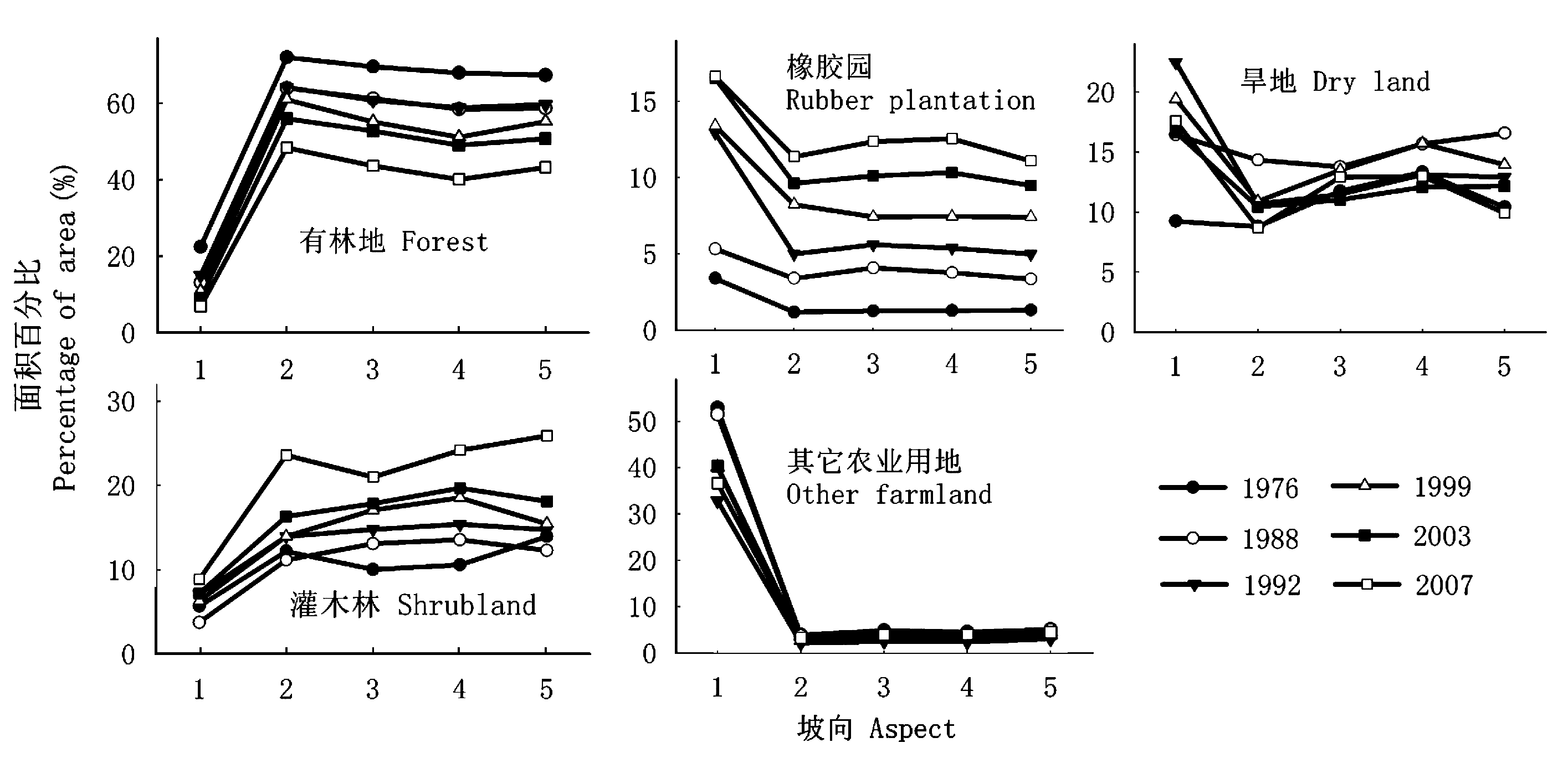
Fig. 5 Area percentage of land use/cover types in different aspects
| 坡向 Aspect | 总面积 Total area (hm2) | 土地利用/覆盖类型 Land use/cover types | 年变化率 Annual changes in percentage (%) | ||||
|---|---|---|---|---|---|---|---|
| 1976~1988 | 1988~1992 | 1992~1999 | 1999~2003 | 2003~2007 | |||
| 平地 Flat | 6 904 | 有林地 Forest | -0.78 | 0.48 | -0.59 | -0.45 | -0.54 |
| 灌木林 Shrubland | -0.16 | 0.84 | -0.11 | 0.22 | 0.42 | ||
| 橡胶园 Rubber plantation | 0.16 | 0.45 | 0.13 | 0.11 | 0.16 | ||
| 农业用地 Farmland | 0.51 | -1.64 | 0.47 | 0.03 | -0.44 | ||
| 北坡 North | 493 468 | 有林地 Forest | -0.67 | 0.06 | -0.45 | -1.26 | -1.90 |
| 灌木林 Shrubland | -0.09 | 0.70 | 0.00 | 0.59 | 1.82 | ||
| 橡胶园 Rubber plantation | 0.19 | 0.40 | 0.46 | 0.35 | 0.44 | ||
| 农业用地 Farmland | 0.45 | -1.22 | 0.16 | 0.13 | -0.32 | ||
| 东坡 East | 447 575 | 有林地 Forest | -0.70 | -0.10 | -0.80 | -0.60 | -2.29 |
| 灌木林 Shrubland | 0.25 | 0.43 | 0.32 | 0.19 | 0.79 | ||
| 橡胶园 Rubber plantation | 0.23 | 0.38 | 0.26 | 0.67 | 0.56 | ||
| 农业用地 Farmland | 0.11 | -0.87 | 0.42 | -0.30 | 0.86 | ||
| 南坡 South | 508 489 | 有林地 Forest | -0.79 | 0.07 | -1.09 | -0.53 | -2.23 |
| 灌木林 Shrubland | 0.25 | 0.45 | 0.45 | 0.28 | 1.13 | ||
| 橡胶园 Rubber plantation | 0.21 | 0.40 | 0.24 | 0.82 | 0.53 | ||
| 农业用地 Farmland | 0.18 | -1.00 | 0.54 | -0.58 | 0.48 | ||
| 西坡 West | 458 829 | 有林地 Forest | -0.72 | 0.26 | -0.64 | -1.11 | -1.89 |
| 灌木林 Shrubland | -0.14 | 0.62 | 0.10 | 0.67 | 1.94 | ||
| 橡胶园 Rubber plantation | 0.17 | 0.41 | 0.35 | 0.52 | 0.40 | ||
| 农业用地 Farmland | 0.51 | -1.34 | 0.34 | -0.24 | -0.44 | ||
Table 5 Annual changes in percentage of land use/cover at different aspects from 1976 to 2007
| 坡向 Aspect | 总面积 Total area (hm2) | 土地利用/覆盖类型 Land use/cover types | 年变化率 Annual changes in percentage (%) | ||||
|---|---|---|---|---|---|---|---|
| 1976~1988 | 1988~1992 | 1992~1999 | 1999~2003 | 2003~2007 | |||
| 平地 Flat | 6 904 | 有林地 Forest | -0.78 | 0.48 | -0.59 | -0.45 | -0.54 |
| 灌木林 Shrubland | -0.16 | 0.84 | -0.11 | 0.22 | 0.42 | ||
| 橡胶园 Rubber plantation | 0.16 | 0.45 | 0.13 | 0.11 | 0.16 | ||
| 农业用地 Farmland | 0.51 | -1.64 | 0.47 | 0.03 | -0.44 | ||
| 北坡 North | 493 468 | 有林地 Forest | -0.67 | 0.06 | -0.45 | -1.26 | -1.90 |
| 灌木林 Shrubland | -0.09 | 0.70 | 0.00 | 0.59 | 1.82 | ||
| 橡胶园 Rubber plantation | 0.19 | 0.40 | 0.46 | 0.35 | 0.44 | ||
| 农业用地 Farmland | 0.45 | -1.22 | 0.16 | 0.13 | -0.32 | ||
| 东坡 East | 447 575 | 有林地 Forest | -0.70 | -0.10 | -0.80 | -0.60 | -2.29 |
| 灌木林 Shrubland | 0.25 | 0.43 | 0.32 | 0.19 | 0.79 | ||
| 橡胶园 Rubber plantation | 0.23 | 0.38 | 0.26 | 0.67 | 0.56 | ||
| 农业用地 Farmland | 0.11 | -0.87 | 0.42 | -0.30 | 0.86 | ||
| 南坡 South | 508 489 | 有林地 Forest | -0.79 | 0.07 | -1.09 | -0.53 | -2.23 |
| 灌木林 Shrubland | 0.25 | 0.45 | 0.45 | 0.28 | 1.13 | ||
| 橡胶园 Rubber plantation | 0.21 | 0.40 | 0.24 | 0.82 | 0.53 | ||
| 农业用地 Farmland | 0.18 | -1.00 | 0.54 | -0.58 | 0.48 | ||
| 西坡 West | 458 829 | 有林地 Forest | -0.72 | 0.26 | -0.64 | -1.11 | -1.89 |
| 灌木林 Shrubland | -0.14 | 0.62 | 0.10 | 0.67 | 1.94 | ||
| 橡胶园 Rubber plantation | 0.17 | 0.41 | 0.35 | 0.52 | 0.40 | ||
| 农业用地 Farmland | 0.51 | -1.34 | 0.34 | -0.24 | -0.44 | ||
| [1] | Fang JY (方精云), Shen ZH (沈泽昊), Cui HT (崔海亭) (2004). Ecological characteristics of mountains and research issues of mountain ecology. Biodiversity Science (生物多样性), 12,10-19. (in Chinese with English abstract) |
| [2] | Feng CY (冯朝阳), Yu Y (于勇), Gao JX (高吉喜), Han YW (韩永伟) (2007). Influences of topographic on distribution and change of land use and cover in Mentougou district, Beijing. Journal of Mountain Science (山地学报), 25,274-279. (in Chinese with English abstract) |
| [3] |
Foley JA, DeFries R, Asner GP, Barford C, Bonan G, Carpenter SR, Chapin FS, Coe MT, Daily GC, Gibbs HK, Helkowski JH, Holloway T, Howard EA, Kucharik CJ, Monfreda C, Patz JA, Prentice LC, Ramankutty N, Snyder PK (2005). Global consequences of land use. Science, 309,570-574.
DOI URL PMID |
| [4] |
Fox J, Vogler JB (2005). Land-use and land-cover change in montane mainland Southeast Asia. Environmental Management, 36,394-403.
URL PMID |
| [5] | Gong SX (宫世贤), Ling SH (凌升海) (1996). Fog decreasing in Xishuangbanna region. Meteorological Monthly (气象), 22(11),10-14. (in Chinese with English abstract) |
| [6] | He YL (何云玲), Zhang YP (张一平), Yang XB (杨小波) (2007). Climate change in tropical area of southern China since 1950s. Scientia Geographica Sinica (地理科学), 27,499-505. (in Chinese with English abstract) |
| [7] | Hietel E, Waldhardt R, Otte A (2004). Analysing land-cover changes in relation to environmental variables in Hesse, Germany. Landscape Ecology, 19,473-489. |
| [8] | International Rubber Study Group (2007). Statistical Summary of World Rubber Situation. http://www.rubberstudy.com/statistics-quarstat.aspx. Cited 20 Jan 2008. |
| [9] | Jiang AL (江爱良), Qian P (钱平) (1985). A study of the relationship between nocturnal cooling process in winter on different-facing slopes in Xishuangbanna and the chilling injury of rubber trees. Chinese Journal of Tropical Crops (热带作物学报), 6(2),1-12. (in Chinese with English abstract) |
| [10] | Jiang XB (江晓波), Ma ZZ (马泽忠), Zeng WR (曾文蓉), Zhou WC (周万村), Zhou AX (周爱霞), Li AN (李爱农), Sun YQ (孙育秋) (2004). Land-use/cover change process and driving force analysis in three gorges area. Journal of Soil and Water Conservation (水土保持学报), 18(4),108-112. (in Chinese with English abstract) |
| [11] | Lambin EF, Turner BL, Geist HJ, Agbola SB, Angelsen A, Bruce JW, Coomes OT, Dirzo R, Fischer G, Folke C, George PS, Homewood K, Imbernon J, Leemans R, Li XB, Moran EF, Mortimore M, Ramakrishnan PS, Richards JF, Skanes H, Steffen W, Stone GD, Svedin U, Veldkamp TA, Vogel C, Xu JC (2001). The causes of land-use and land-cover change: moving beyond the myths. Global Environmental Change, 11,261-269. |
| [12] | Lan GY (兰国玉), Hu YH (胡跃华), Cao M (曹敏), Zhu H (朱华), Wang H (王洪), Zhou SS (周仕顺), Deng XB (邓晓保), Cui JY (崔景云), Huang JG (黄建国), Liu LY (刘林云), Xu HL (许海龙), Song JP (宋军平), He YC (何有才) (2008). Establishment of Xishuangbanna tropical forest dynamics plot: Species compositions and spatial distribution patterns. Acta Phytoecologica Sinica(植物生态学报), 32,287-298. (in Chinese with English abstract) |
| [13] | Li HM (李红梅), Ma YX (马友鑫), Guo ZF (郭宗峰), Liu WJ (刘文俊) (2007). Land use/land cover dynamic change in Xishuangbanna based on RS and GIS technology. Journal of Mountain Science(山地学报), 25,280-289. (in Chinese with English abstract) |
| [14] | Li HM, Aide TM, Ma YX, Liu WJ, Cao M (2007). Demand for rubber is causing the loss of high diversity rain forest in SW China. Biodiversity and Conservation, 16,1731-1745. |
| [15] | Liu DW (刘殿伟), Song KS (宋开山), Wang DD (王丹丹), Zhang SQ (张树清) (2006). Dynamic change of land-use patterns in west part of Songnen Plain. Scientia Geographica Sinica (地理科学), 26,277-283. (in Chinese with English abstract) |
| [16] | Liu WJ (刘文杰), Zhang YP (张一平), Liu YH (刘玉洪), Li HM (李红梅), Duan WP (段文平) (2003). Comparison of fog interception at a tropical seasonal rain forest and a rubber plantation in Xishuangbanna, Southwest China. Acta Ecologica Sinica(生态学报), 23,2379-2386. (in Chinese with English abstract) |
| [17] | Liu WJ (刘文俊), Ma YX (马友鑫), Hu HB (胡华斌), Cao M (曹敏), Li HM (李红梅) (2006). A quantitative analysis on the landscape pattern change in Menglu, Xishuangbanna, China. Acta Ecologica Sinica(生态学报), 26,3088-3097. (in Chinese with English abstract) |
| [18] | Liu WJ (刘文俊), Ma YX (马友鑫), Hu HB (胡华斌), Cao M (曹敏), Wang W (王伟) (2005). Land use and land cover change in the tropical rainforest region of southern Yunnan. Journal of Mountain Science(山地学报), 23,71-79. (in Chinese with English abstract) |
| [19] | Ma KM (马克明), Zhang JY (张洁瑜), Guo XD (郭旭东), Fu BJ (傅伯杰) (2002). Plant diversity of mountains in rural landscapes: the combined influences of topography and land use.. Acta Phytoecologica Sinica(植物生态学报), 26,575-588. (in Chinese with English abstract) |
| [20] | Ma YX (马友鑫), Guo P (郭萍), Zhang YP (张一平), Li YR (李佑荣), Liu YH (刘玉洪) (2002). Climate change and forest fragmentation in Xishuangbanna. In: Chen YY (陈宜瑜) ed. Biodiversity Conservation and Regional Sustainable Development in China: Proceedings of the Fourth National Symposium on the Conservation and Sustainable Use of Biodiversity in China (生物多样性保护与区域可持续发展——第四届全国生物多样性保护与持续利用研讨会论文集). China Forestry Publishing House, Beijing, 262-279. (in Chinese with English abstract) |
| [21] | Pinder JE Ⅲ, Krah GC, White JD, Basham May AM (1997). The relationships between vegetation type and topography in Lassen Volcanic National Park. Pland Ecology, 131,17-29. |
| [22] | Shen ZH (沈泽昊), Zhang QF (张全发), Yue C (岳超), Zhao J (赵俊), Hu ZW (胡志伟), Lü N (吕楠), Tang YY (唐园园) (2006). The spatial pattern of land use/land cover in the water supplying area of the middle-route of the South-to-North Water Diversion (MR-SNWD) Project. Acta Geographica Sinica (地理学报), 61,633-644. (in Chinese with English abstract) |
| [23] | Shi PJ (史培军), Song CQ (宋长青), Jing GF (景贵飞) (2002). Strengthening the study of land use/cover change and its impact on eco-environmental security—the trend of the study of the dynamics of human-nature system based on “Global Chang Open Science Conference 2001” in Amsterdam, Netherlands. Advance in Earth Science (地球科学进展), 17,161-168. (in Chinese with English abstract) |
| [24] | Song KS (宋开山), Liu DW (刘殿伟), Wang ZM (王宗明), Zhang B (张柏), Jin C (金翠), Li F (李方), Liu HJ (刘焕军) (2008). Land use change in Sanjiang Plain and its driving forces analysis since 1954. Acta Geographica Sinica (地理学报), 63,93-104. (in Chinese with English abstract) |
| [25] | Turner M, Wear D, Flamm R (1996). Land ownership and land-cover change in the southern Appalachian Highlands and the Olympic Peninsula. Ecological Applications, 64,1150-1172. |
| [26] | Wang JT (王吉涛), Guo M (郭敏) (2008). Rubber Industry in Xishuangbanna—the Primary Backbone to Rich Prefecture. http://www.ynxxb.com/ci.ndex/show.aspx?id=60014 Cited 12 Mar 2008. |
| [27] | Wang XQ (汪小钦), Wang QM (王钦敏), Li HG (励惠国), Liu GH (刘高焕) (2007). Driving forces of land use change/cover in the Yellow River Delta. Resources Science (资源科学), 29(5),175-181. (in Chinese with English abstract) |
| [28] | Wear DN, Bolstad P (1998). Land-use changes in southern appalachian landscapes: spatial analysis and forecast evaluation. Ecosystems, 1,575-594. |
| [29] | Wear DN, Flamm RO (1993). Public and private forest disturbance regimes in the southern Appalachians. Natural Resource Modeling, 7,379-397. |
| [30] | Wu CJ (吴传钧), Guo HC (郭焕成) (1994). Chinese Land Use (中国土地利用). Science Press,Beijing. (in Chinese) |
| [31] | Wu XP (吴晓莆), Tang ZY (唐志尧), Cui HT (崔海亭), Fang JY (方精云) (2006). Land cover dynamics of different topographic conditions in Beijing. Acta Phytoecologica Sinica(植物生态学报), 30,239-251. (in Chinese with English abstract) |
| [32] |
Xu JC, Fox J, Vogler JB, Zhang PF, Fu YS, Yang LX, Qian J, Leisz S (2005). Land-use and land-cover change and farmer vulnerability in Xishuangbanna prefecture in southwestern China. Environmental Management, 36,404-413.
DOI URL PMID |
| [33] | Xu ZF (许再富) (2004). Approach on ecological effects of Asian elephants isolated from the distribution of bamboo-wild banana and its conservation strategy. Chinese Journal of Ecology(生态学杂志), 23,131-134. (in Chinese with English abstract) |
| [34] | Yang JC (杨景成), Huang JH (黄建辉), Pan QM (潘庆民), Han XG (韩兴国) (2004). Spectroscopic characteristics of soil organic matter in different tropical ecosystems in Xishuangbanna, Southwest China. Acta Phytoecologica Sinica(植物生态学报), 28,623-629. |
| [35] | Zhang KY (张克映), Zhang YP (张一平) (1984). The im-pact of deforestation on local climate in Xishuangbanna. In: The Agriculture Association and the Forestry Association (中国农学会和中国林学会) eds. Forestry and Meteorology Proceeding (林业气象文集). China Meteorological Press, Beijing, 14-23. (in Chinese) |
| [36] | Zhao XB (赵晓彪) (2003). An analysis of the changes of the population of nationalities in Xishuangbanna Autonomous State. Northwest Population (西北人口), 93(3),59-61. (in Chinese with English abstract) |
| [37] | Zhu H (朱华) (1990). The tropical rain forest vegetation in Xishuangbanna. Tropical Geography(热带地理), 10,233-240. (in Chinese with English abstract) |
| [38] | Zhu H, Xu ZF, Wang H, Li BG (2004). Tropical rain forest fragmentation and its ecological and species diversity change in southern Yunnan. Biodiversity and Conservation, 13,1355-1372. |
| [1] | Rao Chaokang, Tang Liang. Characteristics and Drivers of Mangrove Phyllosphere Microbial Communities across Different Tidal Elevations [J]. Chin J Plant Ecol, 2026, 50(预发表): 1-. |
| [2] | WEI Xin, JIANG Lan, ZHENG Chen-Cheng, ZHU Jing, CHEN Bo, LI Wen-Zhou, LAI Shu-Yu, LIU Jin-Fu, HE Zhong-Sheng. Distribution and influencing factors of woody plant sexual systems along elevational gradient on the south slope of Daiyun Mountain [J]. Chin J Plant Ecol, 2026, 50(1): 150-159. |
| [3] | CHEN Kai, YANG Yan, XU Ling, JIANG Zhong-Hua. Variations in seed morphology and germination of Primula denticulata along an elevational gradient in the mountains of southwestern Yunnan, China [J]. Chin J Plant Ecol, 2025, 49(7): 1119-1127. |
| [4] | LIU Xin-Yue, WANG Li-Ping, LIU Chun-He, SUN Yan-Li, LIU Peng, TIAN Yun, JIA Xin, ZHA Tian-Shan, QIAN Duo. Spatial pattern of biomass and its influencing factors for plantations with different stand ages in Beijing [J]. Chin J Plant Ecol, 2025, 49(6): 939-951. |
| [5] | LI Meng-Qi, MIAO Ling-Feng, LI Da-Dong, LONG Yi-Fan, YE Bing-Bing, YANG Fan. Response of mangrove fine root functional traits to sediment nutrient changes at different tide levels in Dongzhaigang, Hainan, China [J]. Chin J Plant Ecol, 2025, 49(4): 552-561. |
| [6] | LI Bo-Wen, ZHOU Yang, LÜ Jing-Ya, A Wang, CHEN Lan-Ying, LIU Shi-Zhang, WU Jing, LÜ Wang-Wang, SUN Jian-Ping, JIA Yue-Feng, ZHAO Kuang, WANG Shi-Ping. Underestimation of mountain species richness on the Qingzang Plateau when using base zone surveys: a case study of mountain vertical vegetation spectrum in the Rongbu River watershed of Mount Qomolangma [J]. Chin J Plant Ecol, 2025, 49(3): 404-414. |
| [7] | LI Xiao-Hua, LIU Jie, LI Dan-Dan, ZHANG Le-Hua. Population structure and dynamic characteristics of the endangered plant Rhododendron xiaoxidongense [J]. Chin J Plant Ecol, 2025, 49(11): 1844-1857. |
| [8] | LI Li-Ping, YU Kun, CHEN Fang-Miao, CHEN Qiang, JING Yu-Hang, NIU Zhen-Guo, HU Chen-Lu, QIN Hai-Ning, HUANG Hui-Ping, TIAN Yi-Chen. Red List Index of Chinese higher plants based on IUCN global assessment data [J]. Chin J Plant Ecol, 2025, 49(10): 1612-1625. |
| [9] | CHEN Xuan-Zheng, ZHU Yao-Jun, GAO Ju-Juan, LIU Yi-Fan, WANG Rong, FANG Tao, LUO Fang-Li, XUE Wei, YU Fei-Hai. Research progress on spatial-temporal variation of plant-soil feedback [J]. Chin J Plant Ecol, 2024, 48(8): 955-966. |
| [10] | WANG Wen-Wei, HAN Wei-Peng, LIU Wen-Wen. Short-term response of leaf functional traits of the invasive plant Spartina alterniflora to a tidal gradient in coastal wetlands [J]. Chin J Plant Ecol, 2023, 47(2): 216-226. |
| [11] | TANG Lu-Yao, FANG Jing, QIAN Hai-Rong, ZHANG Bo-Na, SHANGGUAN Fang-Jing, YE Lin-Feng, LI Shu-Wen, TONG Jin-Lian, XIE Jiang-Bo. Variation and coordination in functional traits along the tree height of Taxodium distichum and Taxodium distichum var. imbricatum [J]. Chin J Plant Ecol, 2023, 47(11): 1561-1575. |
| [12] | HE Lu-Lu, ZHANG Xuan, ZHANG Yu-Wen, WANG Xiao-Xia, LIU Ya-Dong, LIU Yan, FAN Zi-Ying, HE Yuan-Yang, XI Ben-Ye, DUAN Jie. Crown characteristics and its relationship with tree growth on different slope aspects for Larix olgensis var. changbaiensis plantation in eastern Liaoning mountainous area, China [J]. Chin J Plant Ecol, 2023, 47(11): 1523-1539. |
| [13] | ZHAO Chang-Xing, ZHAO Wei-Jun, ZHANG Xing-Lin, LIU Si-Min, MOU Wen-Bo, LIU Jin-Rong. Analyses of intraspecific competition and facilitation of Picea crassifolia in Pailugou Watershed of Qilian Mountains, China [J]. Chin J Plant Ecol, 2022, 46(9): 1027-1037. |
| [14] | ZANG Yong-Xin, MA Jian-Ying, ZHOU Xiao-Bing, TAO Ye, YIN Ben-Feng, Shayaguli JIGEER, ZHANG Yuan-Ming. Effects of extreme drought and extreme precipitation on aboveground productivity of ephemeral plants across different slope positions along sand dunes [J]. Chin J Plant Ecol, 2022, 46(12): 1537-1550. |
| [15] | XIE Meng-Yi, FENG Xiu-Xiu, MA Huan-Fei, HU Han, WANG Jie-Ying, GUO Yao-Xin, REN Cheng-Jie, WANG Jun, ZHAO Fa-Zhu. Characteristics of soil enzyme activities and stoichiometry and its influencing factors in Quercus aliena var. acuteserrata forests in the Qinling Mountains [J]. Chin J Plant Ecol, 2020, 44(8): 885-894. |
| Viewed | ||||||
|
Full text |
|
|||||
|
Abstract |
|
|||||
Copyright © 2026 Chinese Journal of Plant Ecology
Tel: 010-62836134, 62836138, E-mail: apes@ibcas.ac.cn, cjpe@ibcas.ac.cn
![]()