
植物生态学报 ›› 2009, Vol. 33 ›› Issue (6): 1101-1111.DOI: 10.3773/j.issn.1005-264x.2009.06.010
刘建立1,2, 王彦辉1,*( ), 于澎涛1, 程丽莉3, 熊伟1, 徐丽宏1, 杜阿朋1
收稿日期:2009-05-07
接受日期:2009-08-03
出版日期:2009-05-07
发布日期:2021-04-29
通讯作者:
王彦辉
作者简介:*(wangyh@caf.ac.cn)基金资助:
LIU Jian-Li1,2, WANG Yan-Hui1,*(), YU Peng-Tao1, CHENG Li-Li3, XIONG Wei1, XU Li-Hong1, Du A-Peng1
Received:2009-05-07
Accepted:2009-08-03
Online:2009-05-07
Published:2021-04-29
Contact:
WANG Yan-Hui
摘要:
确定土壤水分的植被承载力是我国北方半干旱地区合理调控土壤水分和植被生长关系、科学恢复林草植被的核心问题。我国北方半干旱地区的土壤水分主要来自大气降水, 作为土壤水分限制型生态系统的坡面植被, 植物种类和植被密度等结构特征与降水量紧密相关。根据六盘山石质山区的特点, 基于水量平衡原理, 建立了阴坡华北落叶松(Larix principis-rupprechti)和阳坡草地的土壤水分植被承载力数学模型, 即由4~10月的生长季降雨量(P)计算得到可承载的叶面积指数(Leaf area index, LAI)公式: LAItree= exp((0.773 1×P-186.12)/146.46)和LAIgrass= exp((0.511 2×P-345.93)/227.89), 并提出了考虑坡面水分再分配影响的不同坡位的土壤水分植被承载力计算方法。阴坡华北落叶松的植被承载力(用LAI表示)从坡顶的1.45升高到坡中的4.83, 然后稳定在3.0~3.3。对于阳坡草地, 土壤水分可承载的LAI从坡顶的0.37上升到坡中的0.46, 然后在0.41~0.47之间变动, LAI的计算值与实测值较为接近, 计算结果比较合理。
刘建立, 王彦辉, 于澎涛, 程丽莉, 熊伟, 徐丽宏, 杜阿朋. 六盘山叠叠沟小流域典型坡面土壤水分的植被承载力. 植物生态学报, 2009, 33(6): 1101-1111. DOI: 10.3773/j.issn.1005-264x.2009.06.010
LIU Jian-Li, WANG Yan-Hui, YU Peng-Tao, CHENG Li-Li, XIONG Wei, XU Li-Hong, Du A-Peng. VEGETATION CARRYING CAPACITY BASED ON SOIL WATER ON TYPICAL SLOPES IN THE DIEDIEGOU SMALL WATERSHED OF LIUPAN MOUNTAINS, NORTHWESTERN CHINA. Chinese Journal of Plant Ecology, 2009, 33(6): 1101-1111. DOI: 10.3773/j.issn.1005-264x.2009.06.010
| 样地编号 Plot number | 1-1 | 1-2 | 1-3 | 1-4 | 1-5 | 1-6 | 1-7 | 1-8 | 1-9 | ||||||||||
|---|---|---|---|---|---|---|---|---|---|---|---|---|---|---|---|---|---|---|---|
| 海拔 Altitude (m) | 2 035 | 2 041 | 2 058 | 2 086 | 2 105 | 2 120 | 2 136 | 2 165 | 2 188 | ||||||||||
| 坡度 Slope | 12° | 16° | 25° | 33° | 30° | 35° | 34° | 38° | 40° | ||||||||||
| 坡向 Aspect | SE 30o | SE 34o | SE 40o | SE 45o | SE 42o | SE 35o | SE 32o | SE 31o | SE 34o | ||||||||||
| 优势种 Dominant species | 铁杆蒿(Artemisa vestita)+白羊草(Bothriochloa ischaemum)+茭蒿(Artemisia giraldii) | 铁杆蒿(Artemisa vestita)+百里香(Thymus mongolicus) | 虎榛子(Ostryopsis davidiana)+铁杆蒿(Artemisa vestita) | ||||||||||||||||
| 草本层盖度 Herbage coverage (%) | 75 | 80 | 60 | 50 | 70 | 60 | 45 | 35 | 40 | ||||||||||
| 枯落物层盖度 Litter coverage (%) | 70 | 75 | 45 | 25 | 20 | 15 | 0 | 0 | 0 | ||||||||||
| 总覆盖度 Total coverage (%) | 75 | 80 | 60 | 60 | 75 | 65 | 45 | 45 | 50 | ||||||||||
| 生物量 Biomass (g·m-2) | 378.5 | 408.8 | 401.3 | 346.2 | 373.1 | 368.8 | 352.7 | 359.2 | 320.6 | ||||||||||
| 叶面积指数 Leaf area index (LAI) | 0.56 | 0.57 | 0.49 | 0.44 | 0.55 | 0.50 | 0.45 | 0.30 | 0.32 | ||||||||||
| 土层厚度 Soil thickness (cm) | >100 | >100 | 100 | 55 | 70 | 80 | 50 | 35 | 30 | ||||||||||
| 0~40 cm土壤容重 Bulk density of the soil layer 0-40 cm (g·cm-3) | 1.12 | 1.06 | 1.02 | 1.08 | 1.00 | 0.99 | 1.20 | 1.08 | 1.14 | ||||||||||
表1 典型阳坡草地坡面(1号)上各试验样地特征描述
Table 1 Description of grassland plots (No.1) on a typical sunny slope in small watershed of Diediegou
| 样地编号 Plot number | 1-1 | 1-2 | 1-3 | 1-4 | 1-5 | 1-6 | 1-7 | 1-8 | 1-9 | ||||||||||
|---|---|---|---|---|---|---|---|---|---|---|---|---|---|---|---|---|---|---|---|
| 海拔 Altitude (m) | 2 035 | 2 041 | 2 058 | 2 086 | 2 105 | 2 120 | 2 136 | 2 165 | 2 188 | ||||||||||
| 坡度 Slope | 12° | 16° | 25° | 33° | 30° | 35° | 34° | 38° | 40° | ||||||||||
| 坡向 Aspect | SE 30o | SE 34o | SE 40o | SE 45o | SE 42o | SE 35o | SE 32o | SE 31o | SE 34o | ||||||||||
| 优势种 Dominant species | 铁杆蒿(Artemisa vestita)+白羊草(Bothriochloa ischaemum)+茭蒿(Artemisia giraldii) | 铁杆蒿(Artemisa vestita)+百里香(Thymus mongolicus) | 虎榛子(Ostryopsis davidiana)+铁杆蒿(Artemisa vestita) | ||||||||||||||||
| 草本层盖度 Herbage coverage (%) | 75 | 80 | 60 | 50 | 70 | 60 | 45 | 35 | 40 | ||||||||||
| 枯落物层盖度 Litter coverage (%) | 70 | 75 | 45 | 25 | 20 | 15 | 0 | 0 | 0 | ||||||||||
| 总覆盖度 Total coverage (%) | 75 | 80 | 60 | 60 | 75 | 65 | 45 | 45 | 50 | ||||||||||
| 生物量 Biomass (g·m-2) | 378.5 | 408.8 | 401.3 | 346.2 | 373.1 | 368.8 | 352.7 | 359.2 | 320.6 | ||||||||||
| 叶面积指数 Leaf area index (LAI) | 0.56 | 0.57 | 0.49 | 0.44 | 0.55 | 0.50 | 0.45 | 0.30 | 0.32 | ||||||||||
| 土层厚度 Soil thickness (cm) | >100 | >100 | 100 | 55 | 70 | 80 | 50 | 35 | 30 | ||||||||||
| 0~40 cm土壤容重 Bulk density of the soil layer 0-40 cm (g·cm-3) | 1.12 | 1.06 | 1.02 | 1.08 | 1.00 | 0.99 | 1.20 | 1.08 | 1.14 | ||||||||||
| 样地编号 Plot number | 3-1 | 3-2 | 3-3 | 3-4 | 3-5 | 3-6 | 3-7 | 3-8 | 3-9 |
|---|---|---|---|---|---|---|---|---|---|
| 海拔 Altitude (m) | 1 997 | 2 020 | 2 050 | 2 078 | 2 099 | 2 123 | 2 135 | 2 147 | 2 165 |
| 坡度 Slope | 11o | 12o | 15o | 22o | 24o | 15o | 14o | 14o | 12o |
| 坡向 Aspect | NW 30o | NW 30o | NW 20o | NW 18o | NW 18o | NW 15o | NW 13o | NW 10o | NW 10o |
| 草本层盖度 Herbage coverage (%) | 35 | 30 | 65 | 45 | 35 | 70 | 60 | 60 | 55 |
| 枯落物层盖度 Litter coverage (%) | 1.78 | 1.52 | 3.49 | 2.51 | 4.19 | 4.39 | 2.14 | 0.44 | 0.03 |
| 总覆盖度 Total coverage (%) | 97 | 95 | 97 | 98 | 98 | 80 | 75 | 65 | 60 |
| 林分密度 Forest density (Plant·hm-2) | 1 650 | 1 375 | 1 111 | 1 500 | 1 875 | 625 | 950 | 750 | 400 |
| 树高 Tree height (m) | 8.2 | 9.9 | 9.5 | 8.9 | 9.3 | 5.8 | 4.9 | 4.4 | 2.5 |
| 胸径 DBH(cm) | 8.9 | 9.4 | 9.2 | 9.8 | 8.5 | 6.8 | 5.6 | 5.4 | 2.2 |
| 叶面积指数 LAI | 3.1 | 3.2 | 3.4 | 3.7 | 3.8 | 2.3 | 1.5 | 1.5 | 1.2 |
| 土层厚度 Soil layer thickness (cm) | >200 | >200 | >200 | >200 | >200 | >100 | 100 | 80 | 40 |
| 0~40 cm土壤容重 Bulk density of the soil layer 0-40 cm (g·cm-3) | 1.08 | 1.15 | 1.00 | 0.94 | 0.90 | 1.00 | 0.94 | 1.01 | 0.92 |
表2 典型阴坡华北落叶松坡面(3号)上各样地特征描述
Table 2 Description of plantation plots (No. 3) ofLarix principis-rupprechtiion a typical shady slope in small watershed of Diediegou
| 样地编号 Plot number | 3-1 | 3-2 | 3-3 | 3-4 | 3-5 | 3-6 | 3-7 | 3-8 | 3-9 |
|---|---|---|---|---|---|---|---|---|---|
| 海拔 Altitude (m) | 1 997 | 2 020 | 2 050 | 2 078 | 2 099 | 2 123 | 2 135 | 2 147 | 2 165 |
| 坡度 Slope | 11o | 12o | 15o | 22o | 24o | 15o | 14o | 14o | 12o |
| 坡向 Aspect | NW 30o | NW 30o | NW 20o | NW 18o | NW 18o | NW 15o | NW 13o | NW 10o | NW 10o |
| 草本层盖度 Herbage coverage (%) | 35 | 30 | 65 | 45 | 35 | 70 | 60 | 60 | 55 |
| 枯落物层盖度 Litter coverage (%) | 1.78 | 1.52 | 3.49 | 2.51 | 4.19 | 4.39 | 2.14 | 0.44 | 0.03 |
| 总覆盖度 Total coverage (%) | 97 | 95 | 97 | 98 | 98 | 80 | 75 | 65 | 60 |
| 林分密度 Forest density (Plant·hm-2) | 1 650 | 1 375 | 1 111 | 1 500 | 1 875 | 625 | 950 | 750 | 400 |
| 树高 Tree height (m) | 8.2 | 9.9 | 9.5 | 8.9 | 9.3 | 5.8 | 4.9 | 4.4 | 2.5 |
| 胸径 DBH(cm) | 8.9 | 9.4 | 9.2 | 9.8 | 8.5 | 6.8 | 5.6 | 5.4 | 2.2 |
| 叶面积指数 LAI | 3.1 | 3.2 | 3.4 | 3.7 | 3.8 | 2.3 | 1.5 | 1.5 | 1.2 |
| 土层厚度 Soil layer thickness (cm) | >200 | >200 | >200 | >200 | >200 | >100 | 100 | 80 | 40 |
| 0~40 cm土壤容重 Bulk density of the soil layer 0-40 cm (g·cm-3) | 1.08 | 1.15 | 1.00 | 0.94 | 0.90 | 1.00 | 0.94 | 1.01 | 0.92 |
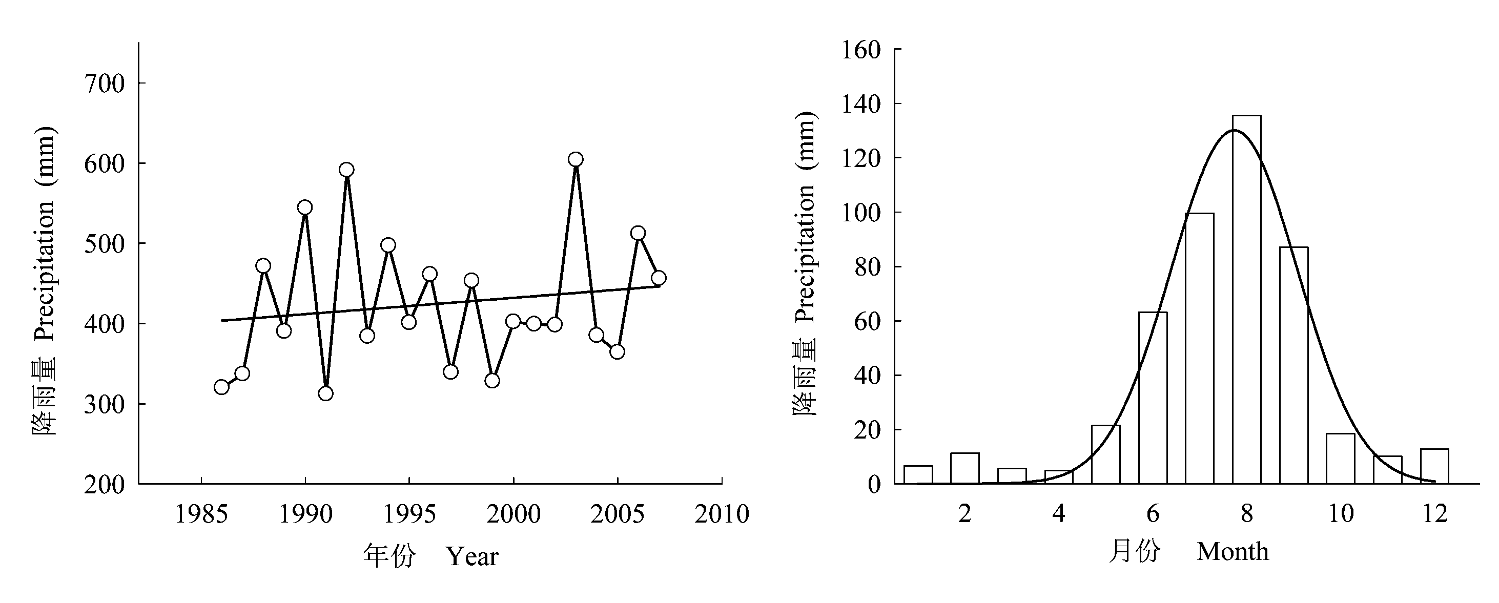
图1 叠叠沟小流域降水年际变化与研究期间季节分配
Fig. 1 The annual dynamics and seasonal distribution of precipitation in Diediegou Catchment
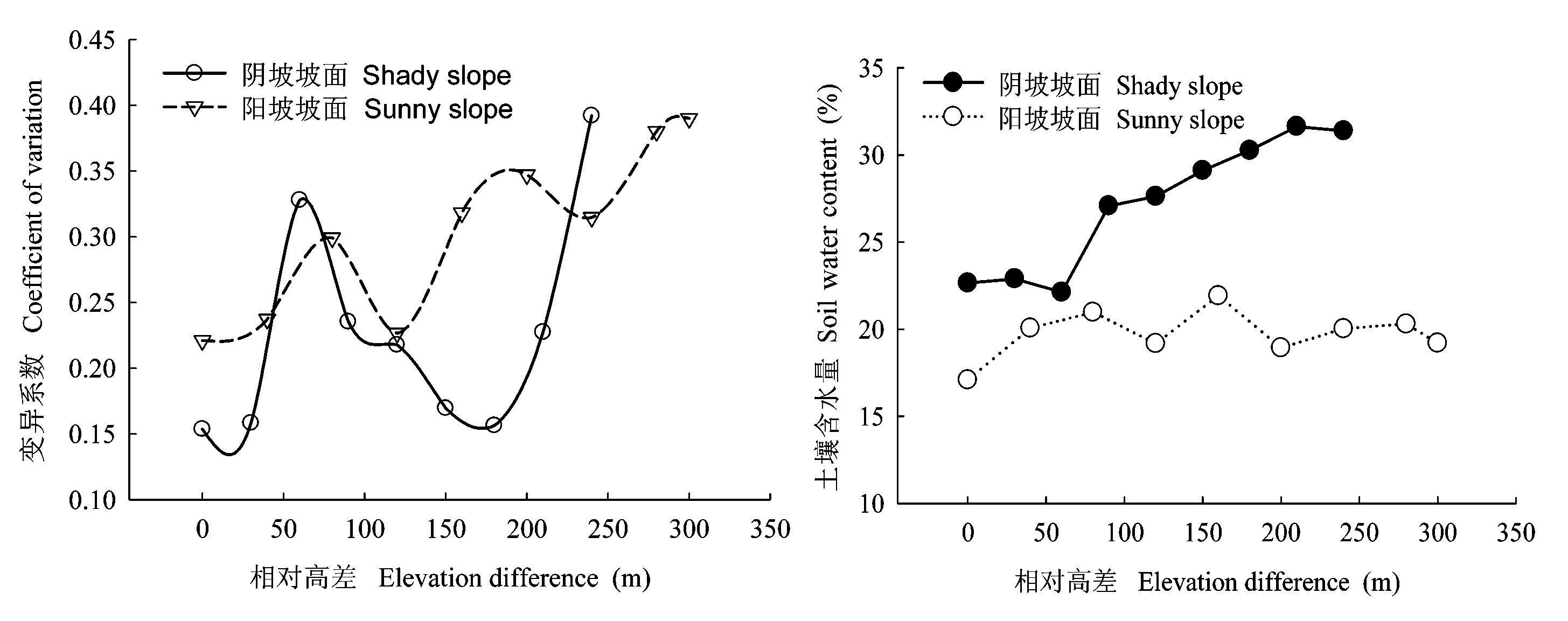
图2 不同坡面的土壤水分沿坡位变化的规律
Fig. 2 Variation of soil water in different slope positions with increasing slope position
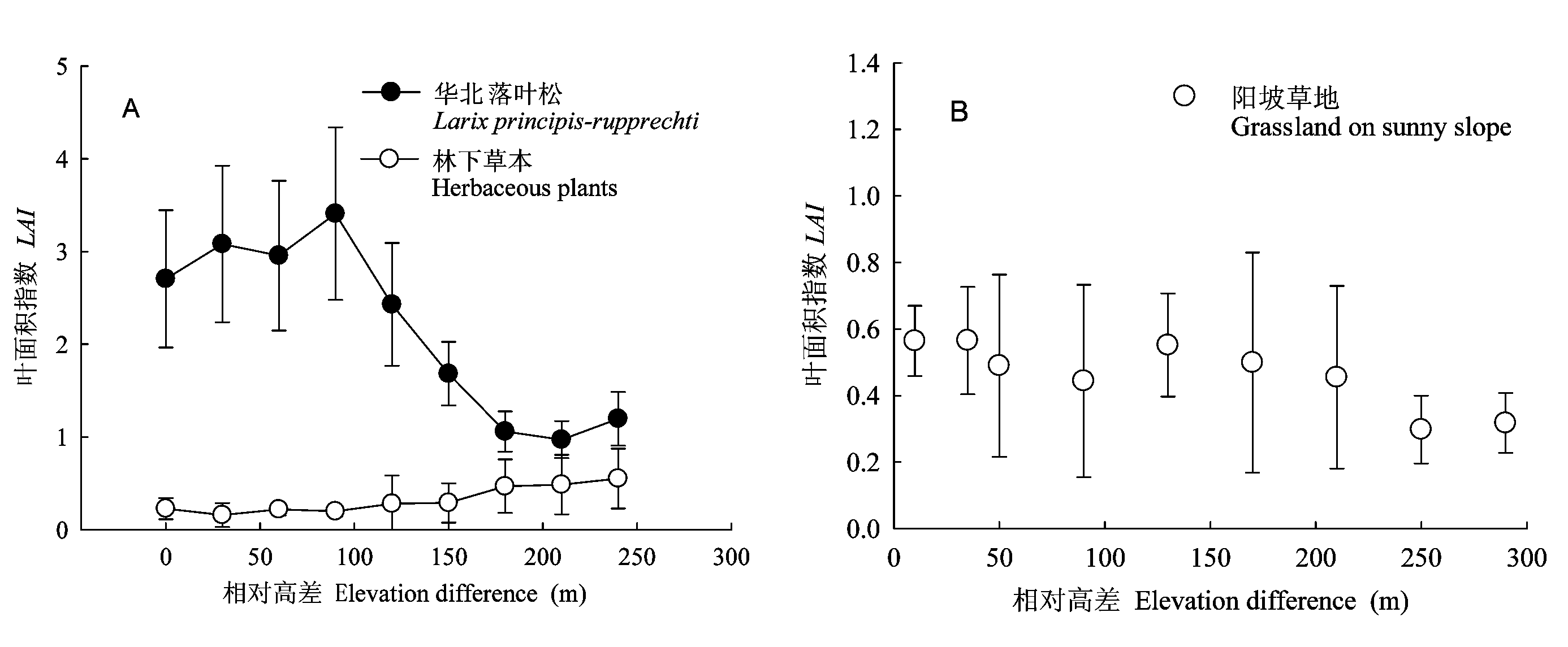
图3 不同坡面植被叶面积指数变化规律(平均值±标准偏差) A: 阴坡坡面 Shady slope B: 阳坡坡面 Sunny slope
Fig. 3 Variation of leaf area index (LAI) on different slopes (mean±SD)
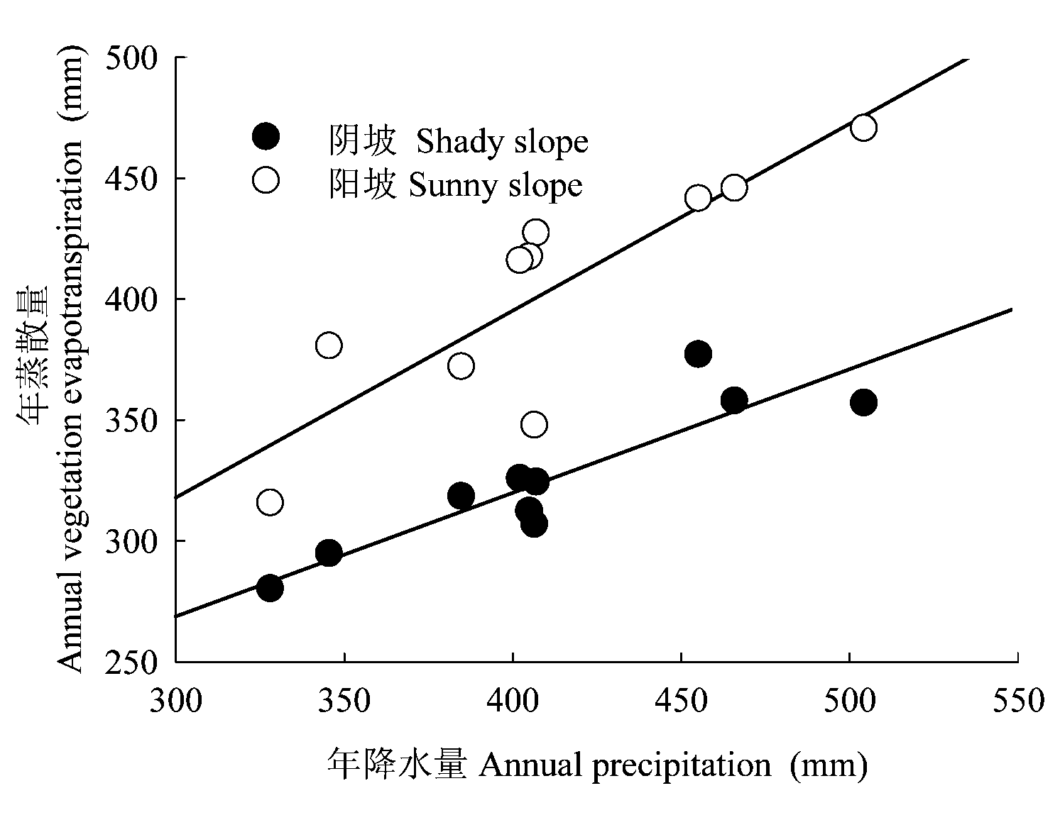
图4 年降水量与年植被蒸散的关系
Fig. 4 Relationship between annual precipitation and vegetation evapotranspiration
| 样地 编号 Plot number | 生长季降雨量 Preci- pitation in growing season (mm) | 实测华北落叶松蒸腾 Mea- sured tree trans- piration (mm) | 实测林下蒸散 Measured under-story evapo- transpiration (mm) | 实测林冠截留 Measured canopy interception (mm) | 实测群落蒸散Measured community evapo- transpiration (mm) | 平衡项 Balance item (mm) | 可供蒸散水分 Soil water available for evapo- transpiration (mm) | 依公式(9)计算的可承载LAI Calculated LAIbased on equation (9) | 实测LAI Measured LAI |
|---|---|---|---|---|---|---|---|---|---|
| (1) | (2) | (3) | (4) | (5) | (6) | (7) | (8) | (9) | (10) |
| 3-1 | 465 | 279.41 | 102.70 | 48.09 | 430.20 | 16.26 | 464.46 | 3.26 | 3.09 |
| 3-2 | 465 | 295.11 | 85.67 | 49.96 | 430.74 | 15.72 | 459.92 | 3.18 | 3.21 |
| 3-3 | 465 | 289.77 | 93.11 | 52.94 | 435.82 | 10.64 | 452.47 | 3.06 | 3.40 |
| 3-4 | 465 | 307.67 | 84.03 | 56.65 | 448.35 | -1.89 | 468.57 | 3.33 | 3.64 |
| 3-5 | 465 | 266.85 | 118.63 | 59.30 | 444.78 | 1.68 | 538.98 | 4.83 | 3.81 |
| 3-6 | 465 | 213.48 | 122.13 | 35.19 | 370.80 | 75.66 | 436.58 | 2.81 | 2.26 |
| 3-7 | 465 | 175.81 | 197.55 | 23.34 | 396.70 | 49.76 | 340.23 | 1.69 | 1.50 |
| 3-8 | 465 | 169.53 | 205.05 | 22.57 | 397.15 | 49.32 | 337.66 | 1.67 | 1.45 |
| 3-9 | 465 | 69.07 | 204.62 | 19.14 | 292.83 | 153.64 | 311.36 | 1.45 | 1.23 |
表3 华北落叶松坡面不同坡位样地植被承载力分析(LAI)
Table 3 Vegetation carrying capacity analysis on different slope positions of Larix principis-rupprechtii slope (LAI)
| 样地 编号 Plot number | 生长季降雨量 Preci- pitation in growing season (mm) | 实测华北落叶松蒸腾 Mea- sured tree trans- piration (mm) | 实测林下蒸散 Measured under-story evapo- transpiration (mm) | 实测林冠截留 Measured canopy interception (mm) | 实测群落蒸散Measured community evapo- transpiration (mm) | 平衡项 Balance item (mm) | 可供蒸散水分 Soil water available for evapo- transpiration (mm) | 依公式(9)计算的可承载LAI Calculated LAIbased on equation (9) | 实测LAI Measured LAI |
|---|---|---|---|---|---|---|---|---|---|
| (1) | (2) | (3) | (4) | (5) | (6) | (7) | (8) | (9) | (10) |
| 3-1 | 465 | 279.41 | 102.70 | 48.09 | 430.20 | 16.26 | 464.46 | 3.26 | 3.09 |
| 3-2 | 465 | 295.11 | 85.67 | 49.96 | 430.74 | 15.72 | 459.92 | 3.18 | 3.21 |
| 3-3 | 465 | 289.77 | 93.11 | 52.94 | 435.82 | 10.64 | 452.47 | 3.06 | 3.40 |
| 3-4 | 465 | 307.67 | 84.03 | 56.65 | 448.35 | -1.89 | 468.57 | 3.33 | 3.64 |
| 3-5 | 465 | 266.85 | 118.63 | 59.30 | 444.78 | 1.68 | 538.98 | 4.83 | 3.81 |
| 3-6 | 465 | 213.48 | 122.13 | 35.19 | 370.80 | 75.66 | 436.58 | 2.81 | 2.26 |
| 3-7 | 465 | 175.81 | 197.55 | 23.34 | 396.70 | 49.76 | 340.23 | 1.69 | 1.50 |
| 3-8 | 465 | 169.53 | 205.05 | 22.57 | 397.15 | 49.32 | 337.66 | 1.67 | 1.45 |
| 3-9 | 465 | 69.07 | 204.62 | 19.14 | 292.83 | 153.64 | 311.36 | 1.45 | 1.23 |
| 样地编号 Plot number | 生长季降雨量 Precipitation in growing season (mm) | 实测群落蒸散量Measured community evapo- transpiration (mm) | 平衡项 Balance item (mm) | 可供蒸散土壤水分 Soil water available for evapotranspiration (mm) | 依公式(10)计算的LAI Calculated LAIbased on equation (10) | 实测LAI Measured LAI |
|---|---|---|---|---|---|---|
| 1-1 | 465 | 291.70 | 173.30 | 338.98 | 0.47 | 0.56 |
| 1-2 | 465 | 292.35 | 172.65 | 339.63 | 0.47 | 0.57 |
| 1-3 | 465 | 253.33 | 211.67 | 300.61 | 0.43 | 0.49 |
| 1-4 | 465 | 229.45 | 235.55 | 276.73 | 0.41 | 0.44 |
| 1-5 | 465 | 285.19 | 179.81 | 332.47 | 0.46 | 0.55 |
| 1-6 | 465 | 258.09 | 206.91 | 305.34 | 0.44 | 0.50 |
| 1-7 | 465 | 235.16 | 229.84 | 282.04 | 0.41 | 0.45 |
| 1-8 | 465 | 246.11 | 218.89 | 289.03 | 0.42 | 0.30 |
| 1-9 | 465 | 230.93 | 234.07 | 230.93 | 0.37 | 0.32 |
表4 阳坡草地坡面不同坡位样地植被承载力分析(LAI)
Table 4 Vegetation carrying capacity analysis on different slope positions of sunny grassland slope (LAI)
| 样地编号 Plot number | 生长季降雨量 Precipitation in growing season (mm) | 实测群落蒸散量Measured community evapo- transpiration (mm) | 平衡项 Balance item (mm) | 可供蒸散土壤水分 Soil water available for evapotranspiration (mm) | 依公式(10)计算的LAI Calculated LAIbased on equation (10) | 实测LAI Measured LAI |
|---|---|---|---|---|---|---|
| 1-1 | 465 | 291.70 | 173.30 | 338.98 | 0.47 | 0.56 |
| 1-2 | 465 | 292.35 | 172.65 | 339.63 | 0.47 | 0.57 |
| 1-3 | 465 | 253.33 | 211.67 | 300.61 | 0.43 | 0.49 |
| 1-4 | 465 | 229.45 | 235.55 | 276.73 | 0.41 | 0.44 |
| 1-5 | 465 | 285.19 | 179.81 | 332.47 | 0.46 | 0.55 |
| 1-6 | 465 | 258.09 | 206.91 | 305.34 | 0.44 | 0.50 |
| 1-7 | 465 | 235.16 | 229.84 | 282.04 | 0.41 | 0.45 |
| 1-8 | 465 | 246.11 | 218.89 | 289.03 | 0.42 | 0.30 |
| 1-9 | 465 | 230.93 | 234.07 | 230.93 | 0.37 | 0.32 |
| [1] | Bi HX (毕华兴), Li XY (李笑吟), Li J (李俊), Guo MX (郭孟霞), Liu X (刘鑫) (2007). Study on suitable vegetation cover on loess area based on soil water balance. Scientia Silvae Sinicae (林业科学), 43,17-23. (in Chinese with English abstract) |
| [2] | Cao JS (曹军胜), Zhu QK (朱清科), Xue ZD (薛智德) (2008). Vegetation carrying capacity of land and vegetation restration and construction in the Loess Plateau region. Journal of Northwest Forestry University (西北林学院学报), 23,39-43. (in Chinese with English abstract) |
| [3] | Cheng JM (程积民), Wan HE (万惠娥) (2002). Vegetation Planning and Soil and Water Conservation in the Loess Plateau (中国黄土高原植被建设与水土保持). China Forestry Publishing House,Beijing. (in Chinese) |
| [4] | Chen YM (陈云明), Liang YM (梁一民), Cheng JM (程积民) (2002). The zonal character of vegetation construction on Loess Plateau. Acta Phytoecologica Sinica (植物生态学报), 26,339-345. (in Chinese with English abstract) |
| [5] | David P (1999). Carrying capacity reconsidered. Population and Environment, 21,5-26. |
| [6] | Federer CA (1995). BROOK90: A Simulation Model for Evaporation, Soil Water, and Streamflow, Version 3.1. Computer freeware and documentation. USDA Forest Service, PO Box 640, Durham NH, 03824. |
| [7] | Fu BJ (傅伯杰), Yang ZJ (杨志坚), Wang YL (王仰麟), Zhang PW (张平文) (2001). A mathematical model for space distribution of soil moisture in Loess Hilly region. Science in China (Series D)(中国科学D辑), 33,185-191. (in Chinese) |
| [8] | Gao Q (高琼), Dong XJ (董学军), Liang N (梁宁) (1996). A study on the optimal vegetation coverage for sandy grassland in northern China based on soil water budget. Acta Ecologica Sinica (生态学报), 16,33-39. (in Chinese with English abstract) |
| [9] | Guo ZS (郭忠升), Shao MA (邵明安) (2003a). Precipitation, soil water and soil water carrying capacity of vegetation. Journal of Natural Resources (自然资源学报), 18,522-528. (in Chinese with English abstract) |
| [10] | Guo ZS (郭忠升), Shao MA (邵明安) (2003b). Soil water carrying capacity of vegetation and soil desiccation in artificial forestry and grassland in semi-arid regions of the Loess Plateau. Acta Ecologica Sinica (生态学报), 23,1640-1647. (in Chinese with English abstract) |
| [11] | He FH (何福红), Huang MB (黄明斌), Dang TH (党廷辉) (2003). Distribution characteristic of dried soil layer in Wangdonggou watershed in gully region of the Loess Plateau. Journal of Natural Resources (自然资源学报), 18,30-36. (in Chinese with English abstract) |
| [12] | Liu JL (刘建立) (2008). Study on the Soil Water Vegetation Carrying Capacity on Slopes in the Small Watershed of Diediegou of Liupan Mountains (六盘山叠叠沟小流域坡面土壤水分植被承载力研究). PhD dissertation, Chinese Academy of Forestry. (in Chinese) |
| [13] | Pan CZ (潘成忠), Shangguan ZP (上官周平) (2004). Spatial variability of soil moisture, nutrients, and productivity on slopeland in loessial semiarid region. Chinese Journal of Applied Ecology (应用生态学报), 2061-2066. (in Chinese with English abstract) |
| [14] | Radersma S, Ong CK, Coe R (2006). Water use of tree lines: importance of leaf area and micrometeorology in sub-humid Kenya. Agroforestry Systems, 66,179-189. |
| [15] | Wang BR (王斌瑞), Wang BT (王百田) (1996). Technique for Runoff Forestry in the Loess Plateau (黄土高原径流林业技术研究). China Forestry Publishing House,Beijing. (in Chinese) |
| [16] | Wang L, Shao MA, Hou QC (2000). Status of dried soil layer in the Yan’an experimental area. Bulletin of Soil and Water Conservation, 20,35-37. |
| [17] | Wang J (王俭), Sun TY (孙铁珩), Li PJ (李培军) (2005). Research progress on environmental carrying capacity. Chinese Journal of Applied Ecology (应用生态学报), 16,768-772. (in Chinese with English abstract) |
| [18] | Wang YH (王彦辉), Jin M (金旻), Yu PT (于澎涛) (2003). The environment problems related with forest/ vegetation and water resources in China and future research requirements. Forest Research (林业科学研究), 16,739-747. (in Chinese with English abstract) |
| [19] | Wang YH (王彦辉), Xiong W (熊伟), Yu PT (于澎涛), Shen ZX (沈振西), Guo MC (郭明春), Guan W (管伟), Ma CM (马长明), Ye B (叶兵), Guo H (郭浩) (2006). Study on the evapotranspiration of forest and vegetation in dryland. Science of Soil and Water Conservation (中国水土保持科学), 4(4),19-25. (in Chinese with English abstract) |
| [20] | Wang YH, Yu PT, Xiong W (2008). Water yield reduction after afforestation and related processes in the semiarid Liupan Mountains, Northwest China. Journal of the American Water Resources Association, 44,1086-1097. |
| [21] | Xia YQ, Shao MA (2008). Soil water carrying capacity for vegetation: a hydrologic and biogeochemical process model solution. Ecological Modelling, 214,112-124. |
| [22] | Xiong W (熊伟) (2003). Studies on Water Consumption Characteristics of Main Plantation Tree Species in the Northern of Liupanshan Mountain (六盘山北侧主要造林树种水分消耗特征研究). PhD dissertation, Chinese Academy of Forestry. (in Chinese) |
| [23] | Yang WX (杨维西) (1996). The preliminary discussion on soil desiccation of artificial vegetation in the northern regions of China. Scientia Silvae Sinicae (林业科学), 32,78-85. (in Chinese with English abstract) |
| [24] | Yang WZ (杨文治), Shao MA (邵明安) (2000). Research of Soil Water in the Loess Plateau (黄土高原土壤水分研究). Science Press, Beijing. (in Chinese) |
| [25] | Zhang WH (张文辉), Liu GB (刘国彬) (2009). Vegatation rehabilitation and building of Loess Plateau.Soil and Water Conservation in China(中国水土保持), 1,24-27. (in Chinese) |
| [26] | Zhu JZ (朱金兆), Wei TX (魏天兴), Zhang XP (张学培) (2002). Arrangement of protective forest system in gulled-hilly loess area based on water balance. Journal of Beijing Forestry University (北京林业大学学报), 24,4-13. (in Chinese with English abstract) |
| [1] | 陈雪萍, 赵学勇, 张晶, 王瑞雄, 卢建男. 基于地理探测器的科尔沁沙地植被NDVI时空变化特征及其驱动因素[J]. 植物生态学报, 2023, 47(8): 1082-1093. |
| [2] | 罗娜娜, 盛茂银, 王霖娇, 石庆龙, 何宇. 长期植被恢复对中国西南喀斯特石漠化土壤活性有机碳组分含量和酶活性的影响[J]. 植物生态学报, 2023, 47(6): 867-881. |
| [3] | 郑周涛, 张扬建. 1982-2018年青藏高原水分利用效率变化及归因分析[J]. 植物生态学报, 2022, 46(12): 1486-1496. |
| [4] | 崔光帅, 罗天祥, 梁尔源, 张林. 干旱半干旱区灌丛对草本植物的促进作用研究进展[J]. 植物生态学报, 2022, 46(11): 1321-1333. |
| [5] | 刘兵兵, 魏建新, 胡天宇, 杨秋丽, 刘小强, 吴发云, 苏艳军, 郭庆华. 卫星遥感监测产品在中国森林生态系统的验证和不确定性分析——基于海量无人机激光雷达数据[J]. 植物生态学报, 2022, 46(10): 1305-1316. |
| [6] | 薛金儒, 吕肖良. 黄土高原生态工程实施下基于日光诱导叶绿素荧光的植被恢复生产力效益评价[J]. 植物生态学报, 2022, 46(10): 1289-1304. |
| [7] | 刘超, 李平, 武运涛, 潘胜难, 贾舟, 刘玲莉. 一种基于数码相机图像和群落冠层结构调查的草地地上生物量估算方法[J]. 植物生态学报, 2022, 46(10): 1280-1288. |
| [8] | 黄松宇, 贾昕, 郑甲佳, 杨睿智, 牟钰, 袁和第. 中国典型陆地生态系统波文比特征及影响因素[J]. 植物生态学报, 2021, 45(2): 119-130. |
| [9] | 邓梦达, 游健荣, 李家湘, 李雄, 杨静, 邓创发, 刘昂, 刘文剑, 丁聪, 谢勇, 周国辉, 喻勋林. 长株潭城市群生态绿心地区主要植被类型的群落特征[J]. 植物生态学报, 2020, 44(12): 1296-1304. |
| [10] | 陈婵, 张仕吉, 李雷达, 刘兆丹, 陈金磊, 辜翔, 王留芳, 方晰. 中亚热带植被恢复阶段植物叶片、凋落物、土壤碳氮磷化学计量特征[J]. 植物生态学报, 2019, 43(8): 658-671. |
| [11] | 王明明,刘新平,何玉惠,张铜会,魏静,车力木格,孙姗姗. 科尔沁沙地封育恢复过程中植物群落特征变化及影响因素[J]. 植物生态学报, 2019, 43(8): 672-684. |
| [12] | 杨焕莹, 宋建达, 周焘, 金光泽, 姜峰, 刘志理. 林分、土壤及空间因子对谷地云冷杉林叶面积指数空间异质性的影响[J]. 植物生态学报, 2019, 43(4): 342-351. |
| [13] | 俞筱押, 李玉辉, 杨光荣. 石林地质公园不同群落类型植物果实组成与种子散布特征[J]. 植物生态学报, 2018, 42(6): 663-671. |
| [14] | 宋小艳, 王根绪, 冉飞, 杨燕, 张莉, 肖瑶. 东北大兴安岭演替初期泰加林灌草层典型植物开花物候与生长对模拟暖干化气候的响应[J]. 植物生态学报, 2018, 42(5): 539-549. |
| [15] | 辜翔, 张仕吉, 刘兆丹, 李雷达, 陈金磊, 王留芳, 方晰. 中亚热带植被恢复对土壤有机碳含量、碳密度的影响[J]. 植物生态学报, 2018, 42(5): 595-608. |
| 阅读次数 | ||||||
|
全文 |
|
|||||
|
摘要 |
|
|||||
Copyright © 2022 版权所有 《植物生态学报》编辑部
地址: 北京香山南辛村20号, 邮编: 100093
Tel.: 010-62836134, 62836138; Fax: 010-82599431; E-mail: apes@ibcas.ac.cn, cjpe@ibcas.ac.cn
备案号: 京ICP备16067583号-19