
植物生态学报 ›› 2023, Vol. 47 ›› Issue (8): 1082-1093.DOI: 10.17521/cjpe.2022.0020
所属专题: 生态遥感及应用
陈雪萍1,3, 赵学勇2,3,*( ), 张晶2, 王瑞雄1,3, 卢建男1,3
收稿日期:2022-01-13
接受日期:2023-03-13
出版日期:2023-08-20
发布日期:2023-04-06
通讯作者:
*赵学勇(基金资助:
CHEN Xue-Ping1,3, ZHAO Xue-Yong2,3,*(), ZHANG Jing2, WANG Rui-Xiong1,3, LU Jian-Nan1,3
Received:2022-01-13
Accepted:2023-03-13
Online:2023-08-20
Published:2023-04-06
Contact:
*ZHAO Xue-Yong(Supported by:摘要:
科尔沁沙地是内蒙古地区典型而且高度退化的农牧交错区域。受气候变化和沙地恢复政策的影响, 该区域近20年来植被发生了显著的变化。该研究基于2001-2020年MOD13A2归一化植被指数(NDVI)数据与10个重要的驱动因子(年平均气温、年降水量、坡度、土壤类型、植被类型、地貌类型、人口密度、累积造林面积、牲畜密度和农作物种植面积)的空间关联, 采用地理探测器模型量化了各驱动因子对科尔沁沙地植被NDVI的影响力和相互作用, 确定了有利于植被生长的各驱动因子的适宜范围。结果表明: (1) 20年来, 科尔沁沙地植被覆盖度逐渐增加, 植被明显恢复地区面积超过64.91%, 主要分布在科尔沁沙地北部、中部以及东南缘区域。(2)土壤类型、地貌类型和年平均气温对科尔沁沙地植被NDVI的影响力较大。(3)各驱动因子之间的交互作用为非线性增强和双因子增强, 其中土壤类型与其他因子存在较强的交互作用。(4)有利于科尔沁沙地植被生长的驱动因子适宜范围, 如: 土壤类型为淋溶土, 地貌类型为丘陵及小起伏山地, 年平均气温4.68-5.67 ℃等环境条件, 能够对植被适应变化环境起到缓冲作用。该研究结果有助于更好地理解植被变化的复杂机制, 为后期科尔沁沙地植被恢复的综合治理以及生态工程的合理实施提供科学依据。
陈雪萍, 赵学勇, 张晶, 王瑞雄, 卢建男. 基于地理探测器的科尔沁沙地植被NDVI时空变化特征及其驱动因素. 植物生态学报, 2023, 47(8): 1082-1093. DOI: 10.17521/cjpe.2022.0020
CHEN Xue-Ping, ZHAO Xue-Yong, ZHANG Jing, WANG Rui-Xiong, LU Jian-Nan. Variation of NDVI spatio-temporal characteristics and its driving factors based on geodetector model in Horqin Sandy Land, China. Chinese Journal of Plant Ecology, 2023, 47(8): 1082-1093. DOI: 10.17521/cjpe.2022.0020
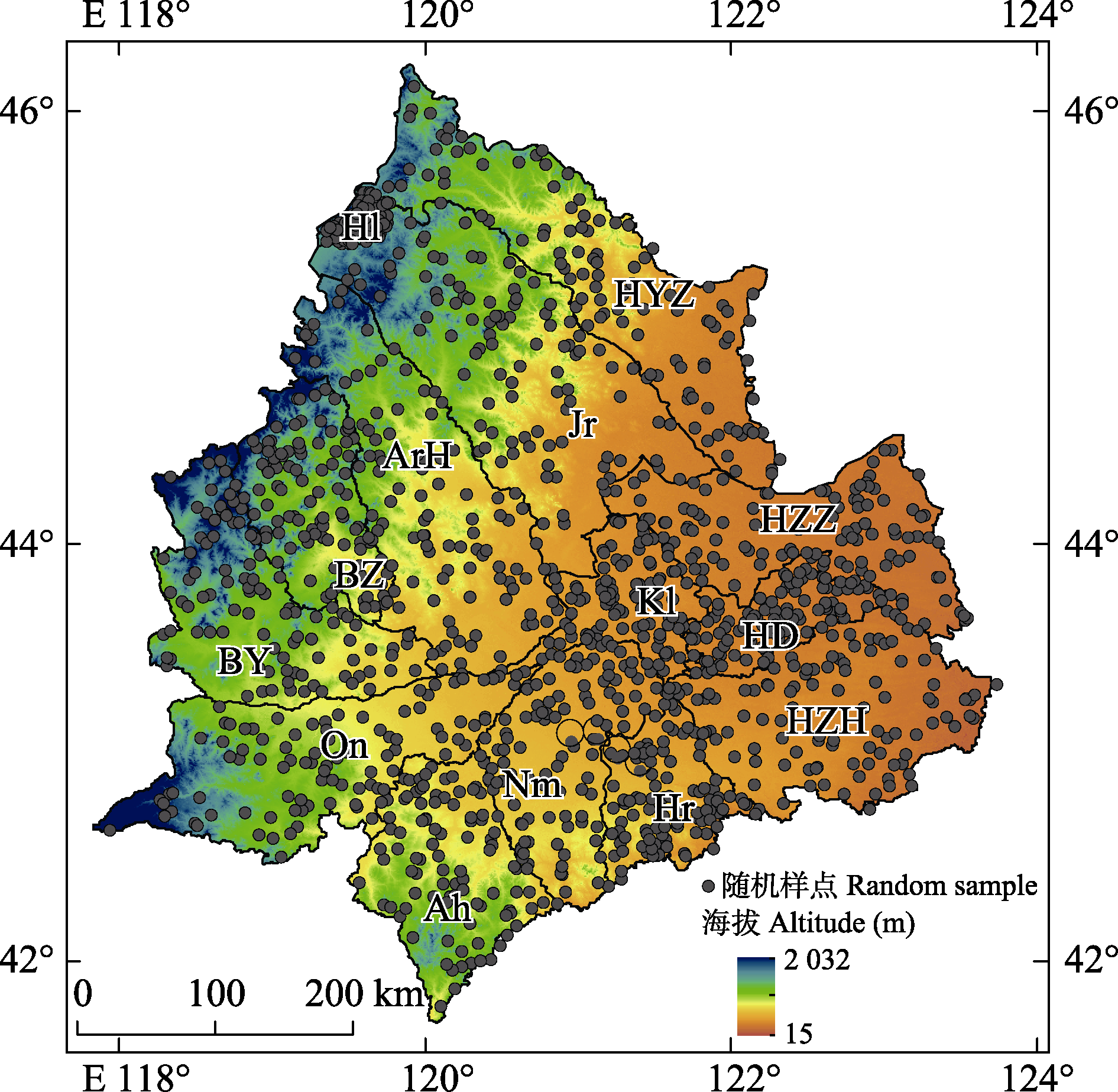
图1 科尔沁沙地随机样点分布图。Ah, 敖汉旗; ArH, 阿鲁科尔沁旗; BY, 巴林右旗; BZ, 巴林左旗; HD, 科尔沁区; Hl, 霍林郭勒市; Hr, 库伦旗; HYZ, 科尔沁右翼中旗; HZH, 科尔沁左翼后旗; HZZ, 科尔沁左翼中旗; Jr, 扎鲁特旗; Kl, 开鲁县; Nm, 奈曼旗; On, 翁牛特旗。
Fig. 1 Distribution of random samples in Horqin Sandy Land. Ah, Aohan Banner; ArH, Ar Horqin Banner; BY, Bairin You Banner; BZ, Bairin Zuo Banner; HD, Horqin District; Hl, Huolingol City; Hr, Hure Banner; HYZ, Horqin Youyi Zhong Banner; HZH, Horqin Zuoyi Hou Banner; HZZ, Horqin Zuoyi Zhong Banner; Jr, Jarud Banner; Kl, Kailu County; Nm, Naiman Banner; On, Ongniutd Banner.
| 类型 Type | 驱动因子 Driving factor | 指标 Index | 单位 Unit | 数据来源 Data resource |
|---|---|---|---|---|
| 自然因素 Natural factor | X1 | 年平均气温 Mean annual temperature | ℃ | 中国气象数据共享网 China Meteorological Data Service Center |
| X2 | 年降水量 Mean annual precipitation | mm | 中国气象数据共享网 China Meteorological Data Service Center | |
| X3 | 坡度 Slope | 。 | 美国NASA获取的SRTM 30 m DEM数据 SRTM 30 m DEM data acquired by NASA | |
| X4 | 土壤类型 Soil type | - | 中国科学院资源环境科学与数据中心 Resource and Environment Science and Data Center, Chinese Academy of Sciences (CAS) | |
| X5 | 植被类型 Vegetation type | - | 中国科学院资源环境科学与数据中心 Resource and Environment Science and Data Center, CAS | |
| X6 | 地貌类型 Geomorphic type | - | 中国科学院资源环境科学与数据中心 Resource and Environment Science and Data Center, CAS | |
| 人为因素 Anthropogenic factor | X7 | 人口密度 Population density | 人·km-2 person·km-2 | 内蒙古自治区统计年鉴 Inner Mongolia Statistical Yearbook |
| X8 | 累积造林面积 Accumulated afforestation area | hm2·km-2 | 中国林业统计年鉴 China Forestry Statistical Yearbook | |
| X9 | 牲畜密度 Livestock density | 头·km-2 head·km-2 | 内蒙古自治区统计年鉴 Inner Mongolia Statistical Yearbook | |
| X10 | 农作物种植面积 Crops area | hm2·km-2 | 内蒙古自治区统计年鉴 Inner Mongolia Statistical Yearbook |
表1 归一化植被指数(NDVI)的驱动因子
Table 1 Driving factors of Normalized Difference Vegetation Index (NDVI)
| 类型 Type | 驱动因子 Driving factor | 指标 Index | 单位 Unit | 数据来源 Data resource |
|---|---|---|---|---|
| 自然因素 Natural factor | X1 | 年平均气温 Mean annual temperature | ℃ | 中国气象数据共享网 China Meteorological Data Service Center |
| X2 | 年降水量 Mean annual precipitation | mm | 中国气象数据共享网 China Meteorological Data Service Center | |
| X3 | 坡度 Slope | 。 | 美国NASA获取的SRTM 30 m DEM数据 SRTM 30 m DEM data acquired by NASA | |
| X4 | 土壤类型 Soil type | - | 中国科学院资源环境科学与数据中心 Resource and Environment Science and Data Center, Chinese Academy of Sciences (CAS) | |
| X5 | 植被类型 Vegetation type | - | 中国科学院资源环境科学与数据中心 Resource and Environment Science and Data Center, CAS | |
| X6 | 地貌类型 Geomorphic type | - | 中国科学院资源环境科学与数据中心 Resource and Environment Science and Data Center, CAS | |
| 人为因素 Anthropogenic factor | X7 | 人口密度 Population density | 人·km-2 person·km-2 | 内蒙古自治区统计年鉴 Inner Mongolia Statistical Yearbook |
| X8 | 累积造林面积 Accumulated afforestation area | hm2·km-2 | 中国林业统计年鉴 China Forestry Statistical Yearbook | |
| X9 | 牲畜密度 Livestock density | 头·km-2 head·km-2 | 内蒙古自治区统计年鉴 Inner Mongolia Statistical Yearbook | |
| X10 | 农作物种植面积 Crops area | hm2·km-2 | 内蒙古自治区统计年鉴 Inner Mongolia Statistical Yearbook |
| 交互作用类型 Interaction type | q值关系 q value relationship |
|---|---|
| 非线性减弱 Non-linear reduction | q(X1∩X2) < min(q(X1), q(X2)) |
| 单因子非线性减弱 Single factor non-linear reduction | min(q(X1), q(X2)) < q(X1∩X2) < max(q(X1), q(X2)) |
| 双因子增强 Bi-factor enhancement | q(X1∩X2) > max(q(X1), q(X2)) |
| 独立 Independent | q(X1∩X2) = q(X1) + q(X2) |
| 非线性增强 Non-linear enhancement | q(X1∩X2) > q(X1) + q(X2) |
表2 两因子间的交互作用类型
Table 2 Interaction type of two factors
| 交互作用类型 Interaction type | q值关系 q value relationship |
|---|---|
| 非线性减弱 Non-linear reduction | q(X1∩X2) < min(q(X1), q(X2)) |
| 单因子非线性减弱 Single factor non-linear reduction | min(q(X1), q(X2)) < q(X1∩X2) < max(q(X1), q(X2)) |
| 双因子增强 Bi-factor enhancement | q(X1∩X2) > max(q(X1), q(X2)) |
| 独立 Independent | q(X1∩X2) = q(X1) + q(X2) |
| 非线性增强 Non-linear enhancement | q(X1∩X2) > q(X1) + q(X2) |
| 分级 Class | X1 (℃) | X2 (mm) | X3 (°) | X4 | X5 | X6 | X7 (person·km-2) | X8 (hm2·km-2) | X9 (head·km-2) | X10 (hm2·km-2) |
|---|---|---|---|---|---|---|---|---|---|---|
| 1 | 4.68-5.67 | 462.77-492.69 | 0-2 | 淋溶土 Alfisol | 针叶林 Needle leaf forest | 平原 Plain | 17.67-41.26 | 1.69-2.94 | 8.99-70.65 | 13.30-13.40 |
| 2 | 5.67-6.45 | 492.69-511.24 | 2-3 | 钙层土 Pedocal | 阔叶林 Broadleaf forest | 台地 Platform | 41.26-49.39 | 2.94-4.41 | 70.65-96.30 | 13.40-16.09 |
| 3 | 6.45-7.07 | 511.24-529.69 | 3-5 | 初育土 Primary | 灌丛 Shrub | 丘陵 Hill | 49.39-56.81 | 4.41-4.89 | 96.30-110.69 | 16.09-18.02 |
| 4 | 7.07-7.66 | 529.69-547.57 | 5-8 | 半水成土 Semi- hydromorph | 草原 Steppe | 小起伏 山地 Small undulating mountain | 56.81-67.65 | 4.89-5.14 | 110.69-118.50 | 18.02-18.89 |
| 5 | 7.66-8.22 | 547.57-566.55 | 8-10 | 水成土 Hydromorph | 草甸 Meadow | 中起伏 山地 Middle undulating mountain | 67.65-86.71 | 5.14-5.29 | 118.50-128.85 | 18.89-20.18 |
| 6 | 8.22-8.72 | 566.55-587.78 | 10-13 | 盐碱土 Saline-alkali | 人工林Artificial forest | 86.71-132.62 | 5.29-5.56 | 128.85-141.48 | 20.18-21.56 | |
| 7 | 8.72-9.32 | 587.78-628.31 | 13-15 | 湖泊水库 Lakes and reservoirs | 132.62-260.95 | 5.56-7.89 | 141.48-224.26 | 21.56-33.17 | ||
| 8 | 15-17 | 河流 Rivers | ||||||||
| 9 | 17-30 | 河内沙洲 Sandbank |
表3 归一化植被指数(NDVI)各驱动因子的分级标准
Table 3 Grading standards of driving factors for Normalized Difference Vegetation Index (NDVI)
| 分级 Class | X1 (℃) | X2 (mm) | X3 (°) | X4 | X5 | X6 | X7 (person·km-2) | X8 (hm2·km-2) | X9 (head·km-2) | X10 (hm2·km-2) |
|---|---|---|---|---|---|---|---|---|---|---|
| 1 | 4.68-5.67 | 462.77-492.69 | 0-2 | 淋溶土 Alfisol | 针叶林 Needle leaf forest | 平原 Plain | 17.67-41.26 | 1.69-2.94 | 8.99-70.65 | 13.30-13.40 |
| 2 | 5.67-6.45 | 492.69-511.24 | 2-3 | 钙层土 Pedocal | 阔叶林 Broadleaf forest | 台地 Platform | 41.26-49.39 | 2.94-4.41 | 70.65-96.30 | 13.40-16.09 |
| 3 | 6.45-7.07 | 511.24-529.69 | 3-5 | 初育土 Primary | 灌丛 Shrub | 丘陵 Hill | 49.39-56.81 | 4.41-4.89 | 96.30-110.69 | 16.09-18.02 |
| 4 | 7.07-7.66 | 529.69-547.57 | 5-8 | 半水成土 Semi- hydromorph | 草原 Steppe | 小起伏 山地 Small undulating mountain | 56.81-67.65 | 4.89-5.14 | 110.69-118.50 | 18.02-18.89 |
| 5 | 7.66-8.22 | 547.57-566.55 | 8-10 | 水成土 Hydromorph | 草甸 Meadow | 中起伏 山地 Middle undulating mountain | 67.65-86.71 | 5.14-5.29 | 118.50-128.85 | 18.89-20.18 |
| 6 | 8.22-8.72 | 566.55-587.78 | 10-13 | 盐碱土 Saline-alkali | 人工林Artificial forest | 86.71-132.62 | 5.29-5.56 | 128.85-141.48 | 20.18-21.56 | |
| 7 | 8.72-9.32 | 587.78-628.31 | 13-15 | 湖泊水库 Lakes and reservoirs | 132.62-260.95 | 5.56-7.89 | 141.48-224.26 | 21.56-33.17 | ||
| 8 | 15-17 | 河流 Rivers | ||||||||
| 9 | 17-30 | 河内沙洲 Sandbank |
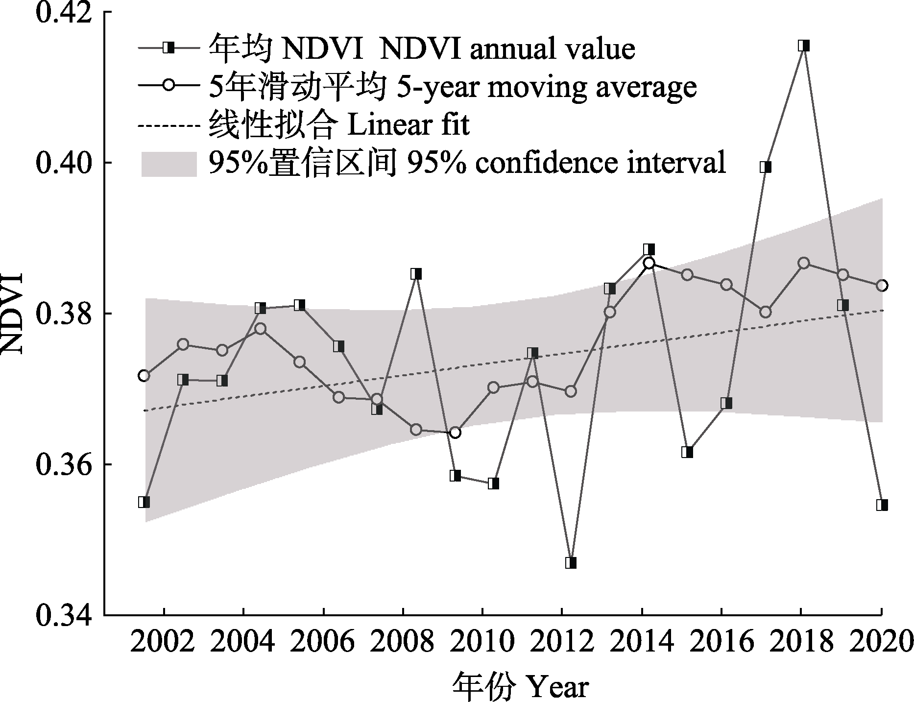
图2 科尔沁沙地2001-2020年归一化植被指数(NDVI)平均值变化趋势。
Fig. 2 Variation trend of mean value of Normalized Difference Vegetation Index (NDVI) in Horqin Sandy Land during 2001-2020.
图3 科尔沁沙地年平均归一化植被指数(NDVI)及变化空间分布。A、B、C分别为2001、2010、2020年研究区NDVI空间分布图。D为研究区2001-2020年NDVI变化趋势图。
Fig. 3 Spatial distribution of Normalized Difference Vegetation Index (NDVI) in Horqin Sandy Land. A, B, C represents the spatial distribution of mean annual NDVI of the study area in 2001, 2010 and 2020, respectively. D shows the variation trend of NDVI in the study area from 2001 to 2020.
| NDVI分级 NDVI class | 2001 | 2010 | 2020 | |||
|---|---|---|---|---|---|---|
| 面积 Area (km2) | 比例 Proportion (%) | 面积 Area (km2) | 比例 Proportion (%) | 面积 Area (km2) | 比例 Proportion (%) | |
| <0.2 | 4 696 | 2.79 | 6 905 | 4.10 | 7 265 | 4.31 |
| 0.2-0.4 | 114 900 | 68.20 | 116 634 | 69.22 | 85 884 | 50.97 |
| 0.4-0.6 | 48 028 | 28.50 | 44 176 | 26.22 | 70 181 | 41.66 |
| ≥0.6 | 866 | 0.51 | 775 | 0.46 | 5 160 | 3.06 |
表4 科尔沁沙地2001-2020年归一化植被指数(NDVI)动态变化
Table 4 Dynamic changes of Normalized Difference Vegetation Index (NDVI) in Horqin Sandy Land during 2001-2020
| NDVI分级 NDVI class | 2001 | 2010 | 2020 | |||
|---|---|---|---|---|---|---|
| 面积 Area (km2) | 比例 Proportion (%) | 面积 Area (km2) | 比例 Proportion (%) | 面积 Area (km2) | 比例 Proportion (%) | |
| <0.2 | 4 696 | 2.79 | 6 905 | 4.10 | 7 265 | 4.31 |
| 0.2-0.4 | 114 900 | 68.20 | 116 634 | 69.22 | 85 884 | 50.97 |
| 0.4-0.6 | 48 028 | 28.50 | 44 176 | 26.22 | 70 181 | 41.66 |
| ≥0.6 | 866 | 0.51 | 775 | 0.46 | 5 160 | 3.06 |
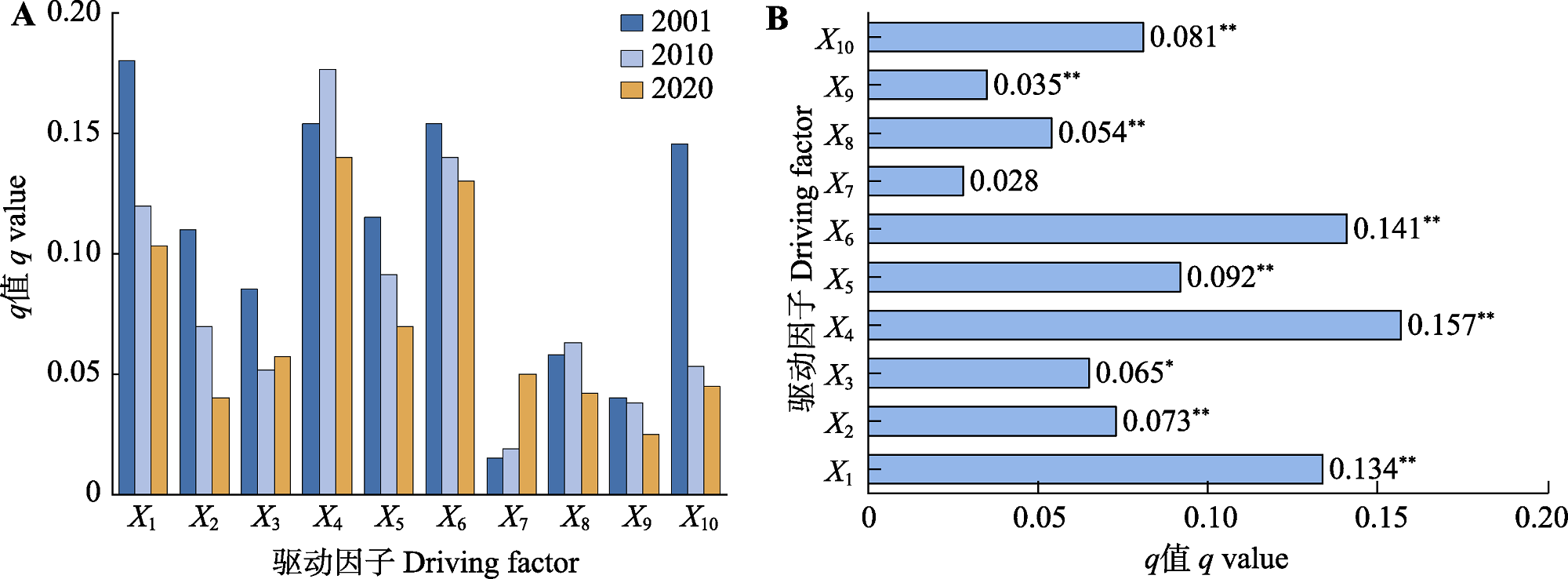
图4 科尔沁沙地驱动因子对归一化植被指数(NDVI)的影响力(q值)。A, 2001、2010、2020年q值。B, 2001-2020年平均q值。X1-X10, 驱动因子名称, 具体见表3。*, p < 0.05; **, p < 0.01。
Fig. 4 Influence (q value) of driving factors for Normalized Difference Vegetation Index (NDVI) in Horqin Sandy Land. A, q value in 2001, 2010, and 2020. B, Mean value of q during 2001-2020. X1-X10, driving factors’ name, see Table 3. *, p < 0.05; **, p < 0.01.
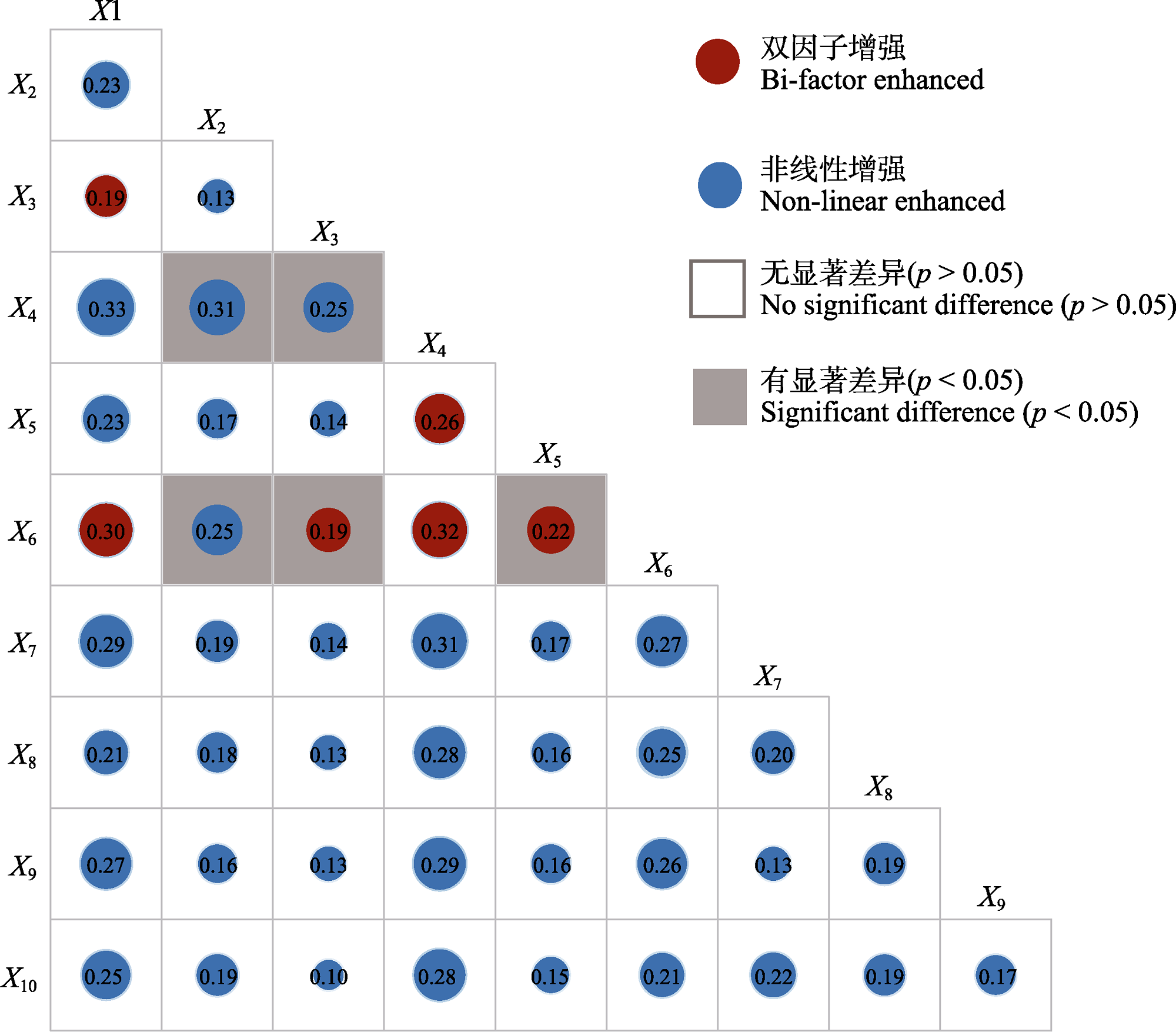
图5 科尔沁沙地驱动因子的交互作用以及显著性差异。X1-X10, 驱动因子名称, 具体见表3。圆圈尺寸表示交互力大小, 圈中的数字表示交互力的q值。
Fig. 5 Interaction and significant difference of driving factors in Horqin Sandy Land. X1-X10, driving factors’ name, see Table 3. Circle size denotes the magnitude of the interaction, numbers in circle indicates q value of driving factors interaction.
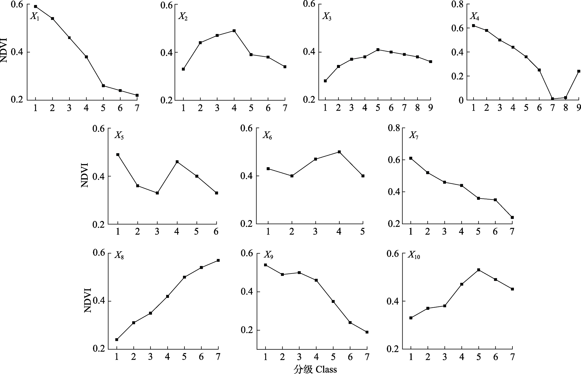
图6 科尔沁沙地归一化植被指数(NDVI)与各驱动因子分级变化。X1-X10, 驱动因子名称, 具体见表3。
Fig. 6 Normalized Difference Vegetation Index (NDVI) changes with different grades for all driving factors in Horqin Sandy Land. X1-X10, driving factors’ name, see Table 3.
| [1] |
Bai HX, Li DY, Ge Y, Wang JF, Cao F (2022). Spatial rough set-based geographical detectors for nominal target variables. Information Sciences, 586, 525-539.
DOI URL |
| [2] | Chen H, Ren ZY (2013). Response of vegetation coverage to changes of precipitation and temperature in Chinese mainland. Bulletin of Soil and Water Conservation, 33, 78-82. |
| [陈欢, 任志远 (2013). 中国大陆植被覆盖对降水与温度变化的响应. 水土保持通报, 33, 78-82.] | |
| [3] | Cui ZZ, Ma C, Chen DK (2021). Spatiotemporal variation of vegetation and climate response in Horqin Sandy Land from 1982 to 2015. Arid Zone Research, 38, 536-544. |
| [崔珍珍, 马超, 陈登魁 (2021). 1982-2015年科尔沁沙地植被时空变化及气候响应. 干旱区研究, 38, 536-544.] | |
| [4] |
Ding Y, Zhang M, Qian X, Li C, Chen S, Wang W (2018). Using the geographical detector technique to explore the impact of socioeconomic factors on PM2.5 concentrations in China. Journal of Cleaner Production, 211, 1480-1490.
DOI URL |
| [5] | Du Y (2021). Analysis of Land Cover Changes and Driving Factors in Horqin Sandy Land in the Past 20 Years. Master degree dissertation, Shanghai Normal University, Shanghai. |
| [杜云 (2021). 科尔沁沙地近20年土地覆被变化及驱动因素分析. 硕士学位论文, 上海师范大学, 上海.] | |
| [6] | Fan JQ, Xu Y, Ge HY, Wei Y (2020). Vegetation growth variation in relation to topography in Horqin Sandy Land. Ecological Indicators, 113, 106215. DOI: 10.1016/j.ecolind.2020.106215. |
| [7] |
Gu Z, Duan X, Shi Y (2018). Spatiotemporal variation in vegetation coverage and its response to climatic factors in the Red River Basin, China. Ecological Indicators, 93, 54-64.
DOI URL |
| [8] | Guo ZC, Wei W, Shi PJ, Zhou L, Wang XF, Li ZY, Pang SF, Xie BB (2020). Temporal and spatial patterns of land desertification sensitivity in arid regions of Northwest China. Acta Geographica Sinica, 75, 154-171. |
| [郭泽呈, 魏伟, 石培基, 周亮, 王旭峰, 李振亚, 庞素菲, 颉斌斌 (2020). 中国西北干旱区土地沙漠化敏感性时空格局. 地理学报, 75, 154-171.] | |
| [9] |
Han Z, Wang T, Yan C, Liu Y, Liu L, Li A, Du H (2010). Change trends for desertified lands in the Horqin Sandy Land at the beginning of the twenty-first century. Environmental Earth Sciences, 59, 1749-1757.
DOI URL |
| [10] |
He B, Chen A, W Jiang, Chen Z (2017). The response of vegetation growth to shifts in trend of temperature in China. Journal of Geographical Sciences, 27, 801-816.
DOI |
| [11] |
Hein L, Ridder N, Hiernaux P, Leemans R (2011). Desertification in the Sahel: towards better accounting for ecosystem dynamics in the interpretation of remote sensing images-Science Direct. Journal of Arid Environments, 75, 164-1172.
DOI URL |
| [12] |
Hope A, Boynton W, Stow D, Douglas D (2003). Interannual growth dynamics of vegetation in the Kuparuk River watershed, Alaska based on the Normalized Difference Vegetation Index. International Journal of Remote Sensing, 24, 3413-3425.
DOI URL |
| [13] | Huang F, Wang P, Liu XN (2008). Monitoring vegetation dynamic in Horqin sandy-land from spot vegetation time series imagery. Remote Sensing, 37, 915-920. |
| [14] | Huang J, Wang J, Bo Y, Xu C, Hu M, Huang D (2014). Identification of health risks of hand, foot and mouth disease in China using the geographical detector technique. International Journal of Environmental Research & Public Health, 11, 3407-3423. |
| [15] | Huo H, Sun CP (2021). Spatiotemporal variation and influencing factors of vegetation dynamics based on Geodetector: a case study of the northwestern Yunnan Plateau, China. Ecological Indicators, 130, 108005. DOI: 10.1016/j.ecolind.2021.108005. |
| [16] | Li J, Liu HB, Li CY, Li L (2017). Research on the beginning period of vegetation growth season in northern China based on GIMMS 3g NDVI in the past 30 years. Chinese Journal of Geography, 37, 620-629. |
|
[李净, 刘红兵, 李彩云, 李龙 (2017). 基于GIMMS 3g NDVI的近30年中国北部植被生长季始期变化研究. 地理科学, 37, 620-629.]
DOI |
|
| [17] | Li SY, Wang XQ, Li B (2016). Spatio-temporal changes of vegetation coverage in Horqin District based on MODIS data. Journal of Yangtze River Scientific Research Institute, 33(2), 122-126. |
| [李生勇, 王晓卿, 李彪 (2016). 基于MODIS数据的科尔沁区植被覆盖时空变化分析. 长江科学院院报, 33(2), 122-126.] | |
| [18] | Liu MZ, Wang YF, Pei HW (2021). Changes in land use and carbon storage in the agro-pastoral ecotone of northern China under the background of returning farmland to forest (grass). Journal of Desert Research, 41(1), 174-182. |
|
[刘孟竹, 王彦芳, 裴宏伟 (2021). 退耕还林(草)背景下中国北方农牧交错带土地利用及碳储量变化. 中国沙漠, 41(1), 174-182.]
DOI |
|
| [19] |
Liu N, Peng SZ, Chen YM (2021). Temporal effects of climate factors on vegetation growth in the Qingzang Plateau. Chinese Journal of Plant Ecology, 45, 1-9.
DOI URL |
| [刘宁, 彭守璋, 陈云明 (2021). 气候因子对青藏高原植被生长的时间效应研究. 植物生态学报, 45, 1-9.] | |
| [20] | Liu XF, Zhu XF, Pan YZ, Li YZ, Zhao AZ (2015). Characteristics of temporal and spatial changes of vegetation cover in China from 1982 to 2012. Acta Ecologica Sinica, 35, 5331-5342. |
| [刘宪锋, 朱秀芳, 潘耀忠, 李宜展, 赵安周 (2015). 1982-2012年中国植被覆盖时空变化特征. 生态学报, 35, 5331-5342.] | |
| [21] |
Liu Z, Liu Y, Li Y (2018). Anthropogenic contributions dominate trends of vegetation cover change over the farming- pastoral ecotone of northern China. Ecological Indicators, 95, 370-378.
DOI URL |
| [22] |
Losada N, Alen E, Cotos T (2019). Spatial heterogeneity in Spain for senior travel behavior. Tourism Management, 70, 444-452.
DOI |
| [23] |
Lu J, Zhan BL, Xu GC, Ren ZP, Li P (2020). Dynamic change of vegetation and its response to climate and topographic factors in the Xijiang River basin, China. Environmental Science and Pollution Research, 27, 11637-11648.
DOI |
| [24] | Luo XL, Li YG, Yin H, Sui M (2020). The response of vegetation NDVI in Northeast China to SPEI at different time scales. Chinese Journal of Ecology, 39, 412-421. |
| [罗新兰, 李英歌, 殷红, 隋明 (2020). 东北地区植被NDVI对不同时间尺度SPEI的响应. 生态学杂志, 39, 412-421.] | |
| [25] | Lv JX, Li XF, Zheng X, Nie Z, Liu SQ (2020). Spatiotemporal changes and driving forces of vegetation in Horqin Sandy Land in the past 40 years. Journal of Ecology, 39, 3-12. |
| [吕家欣, 李秀芬, 郑晓, 聂哲, 刘思嫱 (2020). 近40年科尔沁沙地植被时空变化及其驱动力. 生态学杂志, 39, 3-12.] | |
| [26] | Ma L, Wang JR, Liu XT, Huang X, Liu DH, Li HY (2016). Response relationship between vegetation and climate factors in Horgin Sandy Land from 2000 to 2012. Transactions of the Chinese Society for Agricultural Machinery, 47(4), 162-172. |
| [马龙, 王静茹, 刘廷玺, 黄星, 刘丹辉, 李虹雨 (2016). 2000-2012年科尔沁沙地植被与气候因子间的响应关系. 农业机械学报, 47(4), 162-172.] | |
| [27] | Mu SJ, Zhu C, Zhou KX, Li JL (2017). Research on grassland degradation control countermeasures and ways of increasing carbon sinks in Inner Mongolia. Acta Agrestia Sinica, 25, 217-225. |
|
[穆少杰, 朱超, 周可新, 李建龙 (2017). 内蒙古草地退化防治对策及碳增汇途径研究. 草地学报, 25, 217-225.]
DOI |
|
| [28] |
Parmesan C, Yohe G (2003). A globally coherent fingerprint of climate change impacts across natural systems. Nature, 421, 37-42.
DOI |
| [29] | Peng W, Kuang T, Tao S (2019). Quantifying influences of natural factors on vegetation NDVI changes based on geographical detector in Sichuan, western China. Journal of Cleaner Production, 56, 233-245. |
| [30] | Peng WF, Wang GJ, Zhou JM, Xu XL, Luo HL, Zhao JF, Yang JC (2016). Dynamic monitoring of vegetation coverage in the Wenchuan-Dujiang Weir section of the Minjiang River based on multi-temporal Landsat 5/8 images. Acta Ecologica Sinica, 36, 1975-1988. |
| [彭文甫, 王广杰, 周介铭, 徐新良, 罗怀良, 赵景峰, 杨存建 (2016). 基于多时相Landsat5/8影像的岷江汶川-都江堰段植被覆盖动态监测. 生态学报, 36, 1975-1988.] | |
| [31] | Song Y, Wang J, Ge Y, Xu C (2020). An optimal parameters- based geographical detector model enhances geographic characteristics of explanatory variables for spatial heterogeneity analysis: cases with different types of spatial data. GIScience & Remote Sensing, 57, 593-610. |
| [32] |
Wang J, Wang K, Zhang M, Zhang C (2015). Impacts of climate change and human activities on vegetation cover in hilly southern China. Ecological Engineering, 81, 451-461.
DOI URL |
| [33] | Wang JF, Xu CD (2017). Geodetector: principles and prospects. Acta Geographica Sinica, 72, 116-134. |
|
[王劲峰, 徐成东 (2017). 地理探测器: 原理与展望. 地理学报, 72, 116-134.]
DOI |
|
| [34] |
Wang JF, Zhang TL, Fu BJ (2016). A measure of spatial stratified heterogeneity. Ecological Indicators, 67, 250-256.
DOI URL |
| [35] | Wang T (2003). Desert and Desertification in China. Hebei Science and Technology Publishing House, Shijiazhuang. |
| [王涛 (2003). 中国沙漠与沙漠化. 河北科技出版社, 石家庄.] | |
| [36] | Wang WH, Ma XQ, Zou XH, Tian C, Jin QF, Guo FT (2017). Spatiotemporal evolution characteristics of vegetation coverage in Fujian Province from 2000 to 2010. Research of Soil and Water Conservation, 33, 23-35. |
| [王文辉, 马祥庆, 邹显花, 田超, 靳全峰, 郭福涛 (2017). 2000-2010年福建省植被覆盖度的时空演变特征. 水土保持研究, 33, 23-35.] | |
| [37] |
Wang X, Chen F, Hasi E, Li J (2008). Desertification in China: an assessment. Earth-Science Reviews, 88, 188-206.
DOI URL |
| [38] | Wang X, Li Y, Wang XY (2021). Temporal and spatial variations in NDVI and analysis of the driving factors in the desertified areas of northern China from 1998 to 2015. Frontiers in Environmental Science, 9, 633020. DOI: 10.3389/fenvs.2021.633020. |
| [39] | Wang YY (2016). Research on the Temporal and Spatial Dynamic Changes of Vegetation in Northeast China and Its Response to Climate. PhD dissertation, Northeast Normal University, Changchun. |
| [王彦颖 (2016). 中国东北植被时空动态变化及其对气候响应研究. 博士学位论文, 东北师范大学, 长春.] | |
| [40] | Wei FL, Liu TX, Zhang SW, Ding L, Cui DX, Zhao ZF (2012). Vegetation cover change in Horqin Sandy Land and its relationship with climate factors. Research of Soil and Water Conservation, 19, 254-258. |
| [魏丰良, 刘廷玺, 张圣微, 丁磊, 崔德新, 赵泽锋 (2012). 科尔沁沙地植被覆盖变化及其与气候因子的关系研究. 水土保持研究, 19, 254-258.] | |
| [41] | Wei FY (2007). The Modern Climate Statistical Diagnosis and Prediction Technology. Beijing Metrology Press, Beijing. |
| [魏凤英 (2007). 现代气候统计诊断预测技术. 北京气象出版社, 北京.] | |
| [42] | Xiao Y, Ouyang ZY, Wang LY, Rao EM, Jiang L, Zhang L (2016). Ecosystem quality spatial characteristics and driving forces in Inner Mongolia. Acta Ecologica Sinica, 36, 6019-6030. |
| [肖洋, 欧阳志云, 王莉雁, 饶恩明, 江凌, 张路 (2016). 内蒙古生态系统质量空间特征及其驱动力. 生态学报, 36, 6019-6030.] | |
| [43] | Zhang C (2013). Vegetation Cover Change in Inner Mongolia and Its Relationship with Regional Climate. Master degree dissertation, Nanjing University of Information Science and Technology, Nanjing. |
| [张超 (2013). 内蒙古植被覆盖变化及其与区域气候相互关系. 硕士学位论文, 南京信息工程大学, 南京.] | |
| [44] |
Zhang G, Dong J, Xiao X, Hu Z, Sheldon S (2012). Effectiveness of ecological restoration projects in Horqin Sandy Land, China, based on SPOT-VGT NDVI data. Ecological Engineering, 38, 20-29.
DOI URL |
| [45] | Zhang H, Li M, Song JY, Han HW (2021). Analysis of driving factors of vegetation NDVI changes in Qilian Mountain National Park based on geographic detectors. Chinese Journal of Ecology, 40, 2530-2540. |
| [张华, 李明, 宋金岳, 韩宏武 (2021). 基于地理探测器的祁连山国家公园植被NDVI变化驱动因素分析. 生态学杂志, 40, 2530-2540.] | |
| [46] |
Zhang SY, Nie Y, Zhang HY, Li YL, Han YD, Liu XH, Wang B (2020). Analysis of spatial and temporal changes and driving forces of vegetation NDVI in Inner Mongolia based on geographic detectors. Acta Agrestia Sinica, 28, 1460-1472.
DOI |
|
[张思源, 聂莹, 张海燕, 李永利, 韩燕东, 刘晓煌, 王兵 (2020). 基于地理探测器的内蒙古植被NDVI时空变化与驱动力分析. 草地学报, 28, 1460-1472.]
DOI |
|
| [47] |
Zhang X, Wang J, Gao Y, Wang LX (2021). Variations and controlling factors of vegetation dynamics on the Qingzang Plateau of China over the recent 20 years. Geography and Sustainability, 2, 74-95.
DOI URL |
| [48] | Zhao HL, Dahei JZ, Zhou RL, Li YL, Zuo XA, Huang G (2008). The impact of human activities and climate change on the vegetation of sandy grassland in Horqin. Advances in Earth Science, 4, 408-414. |
| [赵哈林, 大黑俊哉, 周瑞莲, 李玉霖, 左小安, 黄刚 (2008). 人类活动与气候变化对科尔沁沙质草地植被的影响. 地球科学进展, 4, 408-414.] | |
| [49] |
Zhou D, Zhao X, Hu H, Shen H, Fang J (2015). Long-term vegetation changes in the four mega-sandy lands in Inner Mongolia, China. Landscape Ecology, 30, 1613-1626.
DOI URL |
| [50] | Zhou X, Yamaguchi Y, Arjasakusuma S (2018). Distinguishing the vegetation dynamics induced by anthropogenic factors using vegetation optical depth and AVHRR NDVI: a cross-border study on the Mongolian Plateau. Science of the Total Environment, 616, 730-743. |
| [51] | Zhu L, Meng J, Zhu L (2020). Applying geodetector to disentangle the contributions of natural and anthropogenic factors to NDVI variations in the middle reaches of the Heihe River Basin. Ecological Indicators, 117, 106545. DOI: 10.1016/j.ecolind.2020.106545. |
| [1] | 张计深, 史新杰, 刘宇诺, 吴阳, 彭守璋. 气候变化下中国潜在自然植被生态系统碳储量动态[J]. 植物生态学报, 2024, 48(4): 428-444. |
| [2] | 代景忠, 白玉婷, 卫智军, 张楚, 辛晓平, 闫玉春, 闫瑞瑞. 羊草功能性状对施肥的动态响应[J]. 植物生态学报, 2023, 47(7): 943-953. |
| [3] | 罗娜娜, 盛茂银, 王霖娇, 石庆龙, 何宇. 长期植被恢复对中国西南喀斯特石漠化土壤活性有机碳组分含量和酶活性的影响[J]. 植物生态学报, 2023, 47(6): 867-881. |
| [4] | 缪丽娟, 张宇阳, 揣小伟, 包刚, 何昱, 朱敬雯. 亚洲旱区草地NDVI对气候变化的响应及滞后效应[J]. 植物生态学报, 2023, 47(10): 1375-1385. |
| [5] | 朱玉英, 张华敏, 丁明军, 余紫萍. 青藏高原植被绿度变化及其对干湿变化的响应[J]. 植物生态学报, 2023, 47(1): 51-64. |
| [6] | 崔光帅, 罗天祥, 梁尔源, 张林. 干旱半干旱区灌丛对草本植物的促进作用研究进展[J]. 植物生态学报, 2022, 46(11): 1321-1333. |
| [7] | 薛金儒, 吕肖良. 黄土高原生态工程实施下基于日光诱导叶绿素荧光的植被恢复生产力效益评价[J]. 植物生态学报, 2022, 46(10): 1289-1304. |
| [8] | 刘宁, 彭守璋, 陈云明. 气候因子对青藏高原植被生长的时间效应[J]. 植物生态学报, 2022, 46(1): 18-26. |
| [9] | 倪铭, 张曦月, 姜超, 王鹤松. 中国西南部地区植被对极端气候事件的响应[J]. 植物生态学报, 2021, 45(6): 626-640. |
| [10] | 汲玉河, 周广胜, 王树东, 王丽霞, 周梦子. 2000-2019年秦岭地区植被生态质量演变特征及 驱动力分析[J]. 植物生态学报, 2021, 45(6): 617-625. |
| [11] | 陈哲, 汪浩, 王金洲, 石慧瑾, 刘慧颖, 贺金生. 基于物候相机归一化植被指数估算高寒草地植物地上生物量的季节动态[J]. 植物生态学报, 2021, 45(5): 487-495. |
| [12] | 周明星, 李登秋, 邹建军. 基于稠密Landsat数据的邛崃山大熊猫栖息地植被变化研究[J]. 植物生态学报, 2021, 45(4): 355-369. |
| [13] | 徐光来, 李爱娟, 徐晓华, 杨先成, 杨强强. 中国生态功能保护区归一化植被指数动态及气候因子驱动[J]. 植物生态学报, 2021, 45(3): 213-223. |
| [14] | 代景忠, 白玉婷, 卫智军, 张楚, 闫瑞瑞. 切根对羊草营养生长期内植物功能性状的影响[J]. 植物生态学报, 2021, 45(12): 1292-1302. |
| [15] | 闫涵, 张云玲, 马松梅, 王春成, 张丹. 黑果枸杞在新疆的适宜分布模拟与局部环境适应性分化[J]. 植物生态学报, 2021, 45(11): 1221-1230. |
| 阅读次数 | ||||||
|
全文 |
|
|||||
|
摘要 |
|
|||||
Copyright © 2022 版权所有 《植物生态学报》编辑部
地址: 北京香山南辛村20号, 邮编: 100093
Tel.: 010-62836134, 62836138; Fax: 010-82599431; E-mail: apes@ibcas.ac.cn, cjpe@ibcas.ac.cn
备案号: 京ICP备16067583号-19