
植物生态学报 ›› 2007, Vol. 31 ›› Issue (5): 787-793.DOI: 10.17521/cjpe.2007.0100 cstr: 32100.14.cjpe.2007.0100
杨佩国1,2,3, 李保国1,*( ), 吕贻忠1, 吴绍洪2, 李静2,3
收稿日期:2006-03-28
接受日期:2006-09-13
出版日期:2007-03-28
发布日期:2007-09-30
作者简介:* E-mail: libg@cau.edu.cn基金资助:
YANG Pei-Guo1,2,3, LI Bao-Guo1,*(), LÜ Yi-Zhong1, WU Shao-Hong2, LI Jing2,3
Received:2006-03-28
Accepted:2006-09-13
Online:2007-03-28
Published:2007-09-30
摘要:
该文应用气象数据、土壤物理属性实测数据、土壤水分分布式动态模型和植被表面净辐射模型的模拟结果,利用多元线性回归分析方法,建立了植被净第一性生产力模型,实现了鄂尔多斯高原东部砂质荒漠化地区考考赖沟流域尺度上30 m×30 m空间分辨率的植被生产力精确模拟,并且用植被生产力的野外实测数据对模拟结果进行了验证表明: 实测值与模拟值在固定沙丘、半固定沙丘和样线2上都达到0.05显著性相关水平;不同位置的实测植被生产力数据多分布在1∶1直线附近,模拟值与实测值吻合较好;植被生产力实测值与模拟值的相对误差范围为3.22%~6.27%,偏斜度范围在-12.84%~4.43%。该文的研究方法可以为流域尺度上植被生产力的精确模拟提供借鉴和参考。
杨佩国, 李保国, 吕贻忠, 吴绍洪, 李静. 考考赖沟流域植被生产力模拟. 植物生态学报, 2007, 31(5): 787-793. DOI: 10.17521/cjpe.2007.0100
YANG Pei-Guo, LI Bao-Guo, LÜ Yi-Zhong, WU Shao-Hong, LI Jing. SIMULATION OF NET PRIMARY PRODUCTION IN KAOKAOLAIGOU WATERSHED, CHINA. Chinese Journal of Plant Ecology, 2007, 31(5): 787-793. DOI: 10.17521/cjpe.2007.0100
| 样点号No. of sample | NPP | Rn | W |
|---|---|---|---|
| 1 | 98.69 | 999.11 | 392.29 |
| 2 | 133.32 | 1 038.64 | 424.84 |
| 3 | 140.51 | 1 041.23 | 430.51 |
| 4 | 96.55 | 971.57 | 387.26 |
| 5 | 126.08 | 1 026.20 | 414.14 |
| 6 | 175.51 | 1 112.03 | 446.17 |
| 7 | 109.55 | 1 004.73 | 398.21 |
| 8 | 82.97 | 949.06 | 362.08 |
| 9 | 191.08 | 1 254.39 | 456.32 |
| 10 | 201.08 | 1 298.42 | 488.93 |
| 11 | 122.12 | 1 015.51 | 403.88 |
| 12 | 224.63 | 1 343.38 | 537.18 |
| 13 | 95.38 | 959.90 | 376.00 |
| 14 | 185.77 | 1 176.67 | 448.93 |
| 15 | 145.42 | 1 055.68 | 436.59 |
表1 样线1上各点输入数据
Table 1 The input data in the line 1
| 样点号No. of sample | NPP | Rn | W |
|---|---|---|---|
| 1 | 98.69 | 999.11 | 392.29 |
| 2 | 133.32 | 1 038.64 | 424.84 |
| 3 | 140.51 | 1 041.23 | 430.51 |
| 4 | 96.55 | 971.57 | 387.26 |
| 5 | 126.08 | 1 026.20 | 414.14 |
| 6 | 175.51 | 1 112.03 | 446.17 |
| 7 | 109.55 | 1 004.73 | 398.21 |
| 8 | 82.97 | 949.06 | 362.08 |
| 9 | 191.08 | 1 254.39 | 456.32 |
| 10 | 201.08 | 1 298.42 | 488.93 |
| 11 | 122.12 | 1 015.51 | 403.88 |
| 12 | 224.63 | 1 343.38 | 537.18 |
| 13 | 95.38 | 959.90 | 376.00 |
| 14 | 185.77 | 1 176.67 | 448.93 |
| 15 | 145.42 | 1 055.68 | 436.59 |
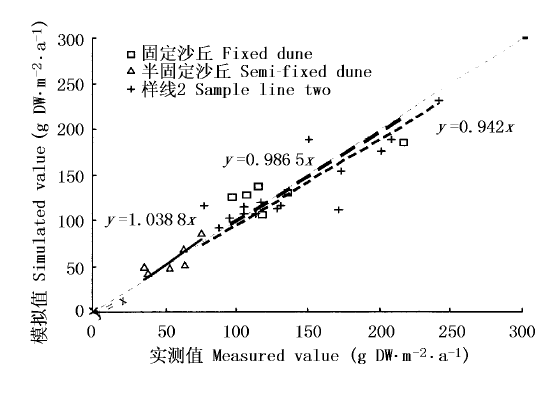
图1 研究区不同位置模拟值与实测值的比较
Fig.1 Comparison of simulated values and measured value at different sites in study area
| 名称 Name | 固定沙丘 Fixed dune | 半固定沙丘 Semi-fixed dune | 样线2 Sample line 2 |
|---|---|---|---|
| 相对误差(%) Relative error | 3.79 | 3.22 | 6.27 |
| 偏斜度 Measure of skewness | 4.43 | 0.58 | -12.84 |
表2 不同位置植被生产力模拟值的相对误差与偏斜度
Table 2 Relative error and bias of linear regression equation with 1 between measured and simulated value
| 名称 Name | 固定沙丘 Fixed dune | 半固定沙丘 Semi-fixed dune | 样线2 Sample line 2 |
|---|---|---|---|
| 相对误差(%) Relative error | 3.79 | 3.22 | 6.27 |
| 偏斜度 Measure of skewness | 4.43 | 0.58 | -12.84 |
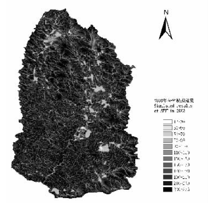
图2 研究区植被净第一性生产力(NPP)(g DW·m-2·a-1)分布图
Fig.2 The distribution of net primary production (NPP) (g DW·m-2·a-1) in study area
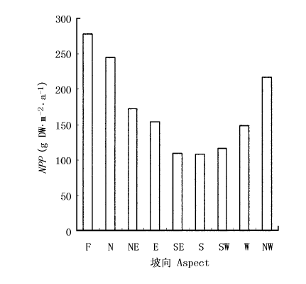
图3 不同坡向上净第一性生产力(NPP)分布 F: 平地 Flat N: 北 North NE: 北东 Northeast E: 东 East SE: 南东 Southeast S: 南 South SW: 南西 Southwest W: 西 West NW: 北西 Northwest
Fig.3 The distribution of net primary production (NPP) on different aspects
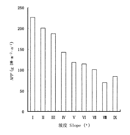
图4 不同坡度上净第一性生产力(NPP)分布
Fig.4 The distribution of net primary production (NPP) in different slopes Ⅰ: 0°~1° Ⅱ: 1°~3° Ⅲ: 3°~5° Ⅳ: 5°~7° Ⅴ: 7°~10° Ⅵ: 10°~15° Ⅶ: 15°~20° Ⅷ: 20°~25° Ⅸ: >25°
| [1] | Dong M (董鸣) (1997). Investigation and Analysis of the Terrestrial Biocommunities (陆地生物群落调查观测与分析). Standards Press of China, Beijing. (in Chinese) |
| [2] | Fang JY (2000). Forest productivity in China and its responses to global climate changes. Acta Phytoecologica Sinica (植物生态学报), 24,513-517. |
| [3] |
Field CB, Behrenfeld MJ, Randerson JT, Falkowski P (1998). Primary production of the biosphere: integrating terrestrial and oceanic components. Science, 281,237-240.
URL PMID |
| [4] | Foley JA (1994). Net primary productivity in the terrestrial bio-sphere: the application of a global model. Journal of Geophysical Resource, 99(D10),20773-20783. |
| [5] | Fu BP (傅抱璞) (1998). The differences and variations in components of radiation budget on underlying surfaces of different topographies. Chinese Journal of Atmospheric Sciences (大气科学), 22,178-190. (in Chinese with English abstract) |
| [6] | Fu BP (傅抱璞) (1983). Mountain Climate (山地气候).Science Press, Beijing,61-72. (in Chinese) |
| [7] | Hou GL (侯光良), You SC (游松才) (1990). To calculate China's plant-climate productive potentialities by Chikuzo model. Journal of Natural Resources (自然资源学报), 5,60-65. (in Chinese with English abstract) |
| [8] | Li DQ (李迪强), Sun CY (孙成永), Zhang XS (张新时) (1998). Modelling the net primary productivity of the natural potential vegetation in China. Acta Botanica Sinica (植物学报), 40,560-566. (in Chinese with English abstract) |
| [9] | Matsushita BK, Yang CF (杨翠芬), Chen J (陈晋), Wang QX (王勤学), Kameyama STS, Tamura MSYK (2004). Accurate estimation of net primary productivity of terrestrial ecosystem at a regional scale. Acta Geographica Sinica (地理学报), 59,80-87. (in Chinese with English abstract) |
| [10] | Meiillo JM, McGuire AD (1993). Global climate change and terrestrial net primary production. Nature, 363,234-240. |
| [11] | Ni J (倪健) (2002). BIOME models: main principles and applications. Acta Phytoecologica Sinica (植物生态学报), 26,481-488. (in Chinese with English abstract) |
| [12] | Niu ZG (牛振国), Li BG (李保国), Zhang FR (张凤荣) (2003). Modeling of soil water replenishment in catchments based on GIS. Journal of Hydraulic Engineering (水利学报), 2,73-77. (in Chinese with English abstract) |
| [13] | Niu ZG (牛振国), Li BG (李保国), Zhang FR (张凤荣), Chen HW (陈焕伟) (2002). A distributed model of reference evapotranspiration based on the DEM. Advances in Water Science (水科学进展), 13,303-307. (in Chinese with English abstract) |
| [14] | Paruelo JM (1997). A NPP estimates from NDVI for the central grassland region of the United States. Ecology, 78,953-958. |
| [15] | Piao SL (朴世龙), Fang JY (方精云), Guo QH (郭庆华) (2001). Application of CASA model to the estimation of Chinese terrestrial net primary productivity. Acta Phytoecologica Sinica (植物生态学报), 25,603-608. (in Chinese with English abstract) |
| [16] | Potter CS (1999). Terrestrial biomass and effects of deforestation on the global carbon cycle-results from a model of primary production using satellite observations. BioScience, 49,769-778. |
| [17] | Potter CS, Randerson JT (1993). Terrestrial ecosystem production: a process model based on global satellite and surface data. Global Biogeochemical Cycles, 7,811-841. |
| [18] | Smith M (1991). Report on the Expert Consultation on Revision of FAO Methodologies for Crop Water Requirements. Land and Water Development Division, Food and Agriculture Organization, Rome, 54. |
| [19] | Sun R (孙睿), Zhu QJ (朱启疆) (2001). Effect of climate change of terrestrial net primary productivity in China. Journal of Remote Sensing (遥感学报), 5,58-61. (in Chinese with English abstract) |
| [20] | Sun R (孙睿), Zhu QJ (朱启疆) (1999). Net primary productivity of terrestrial vegetation—a review on related researches. Chinese Journal of Applied Ecology (应用生态学报), 10,757-760. (in Chinese with English abstract) |
| [21] | Uchijima Z, Seino H (1985). Agroclimatic evaluation of net primary productivity of nature vegetation (1): Chikugo model for evaluating primary productivity. Journal of Agricultural Meteorology, 40,343-352. |
| [22] | Yan SJ (闫淑君), Hong W (洪伟), Wu CZ (吴承祯), Bi XL (毕晓丽) (2001). Modification of natural vegetation NPP model. Acta Agriculturae Universitatis Jiangxiensis (江西农业大学学报), 23,248-252. (in Chinese with English abstract) |
| [23] | Yang YH (杨永辉), Wang ZP (王智平), Sakura YS, Tang CY (唐常源), Shindo SZ (2002). Effects of global warming on productivity and soil moisture in Taihang Mountain: a transplant study. Chinese Journal of Applied Ecology (应用生态学报), 13,667-671. (in Chinese with English abstract) |
| [24] | Zhang H (张洪), Fan ZL (樊自立) (2000). Studies on a NPP model of salinized meadow in the north of Tarim Basin. Acta Phytoecologica Sinica (植物生态学报), 24,13-17. (in Chinese with English abstract) |
| [25] | Zhang JH (张佳华) (2001). Study on models for evaluation primary productivity of natural vegetation and corp yield. Acta Agriculturae Shanghai (上海农业学报), 17,83-89. (in Chinese with English abstract) |
| [26] | Zhang XZ (张宪洲) (1993). The estimation and distribution of net primary productivity of natural vegetation in China. Resources Science (资源科学), 1,15-21. (in Chinese with English abstract) |
| [27] | Zheng YR (郑元润), Zhou GS (周广胜) (2000). A forest vegetation NPP model based on NDVI. Acta Phytoecologica Sinica (植物生态学报), 24,9-12. (in Chinese with English abstract) |
| [28] | Zhou GS (周广胜), Zhang XS (张新时) (1995). A natural vegetation NPP model. Acta Phytoecologica Sinica (植物生态学报), 19,193-200. (in Chinese with English abstract) |
| [29] | Zhou GS (周广胜), Zhang XS (张新时) (1996). Study on NPP of natural vegetation in China under global climate change. Acta Phytoecologica Sinica (植物生态学报), 20,11-19. (in Chinese with English abstract) |
| [30] | Zhou T (周涛), Shi PJ (史培军), Sun R (孙睿), Wang SQ (王绍强) (2004). The impacts of climate change on net ecosystem production in China. Acta Geographica Sinica (地理学报), 59,357-365. (in Chinese with English abstract) |
| [31] | Zhu ZH (朱志辉) (1993). The model of estimating net primary productivity of natural vegetaion. Chinese Science Bulletin (科学通报), 38,1422-1426. (in Chinese with English abstract) |
| [1] | 吴茹茹, 刘美珍, 谷仙, 常馨月, 郭立月, 蒋高明, 祁如意. 气候变化对巨柏适宜生境分布的潜在影响和预测[J]. 植物生态学报, 2024, 48(4): 445-458. |
| [2] | 王秀英, 陈奇, 杜华礼, 张睿, 马红璐. 基于机器学习的青藏高原高寒沼泽湿地蒸散发插补研究[J]. 植物生态学报, 2023, 47(7): 912-921. |
| [3] | 郭敏, 罗林, 梁进, 王彦杰, 赵春章. 冻融变化对西南亚高山森林优势种云杉和华西箭竹根区土壤理化性质与酶活性的影响[J]. 植物生态学报, 2023, 47(6): 882-894. |
| [4] | 陈奕竹, 郎伟光, 陈效逑. 中国北方树木秋季物候的过程模拟及其区域分异归因[J]. 植物生态学报, 2022, 46(7): 753-765. |
| [5] | 刘兵兵, 魏建新, 胡天宇, 杨秋丽, 刘小强, 吴发云, 苏艳军, 郭庆华. 卫星遥感监测产品在中国森林生态系统的验证和不确定性分析——基于海量无人机激光雷达数据[J]. 植物生态学报, 2022, 46(10): 1305-1316. |
| [6] | 魏春雪, 杨璐, 汪金松, 杨家明, 史嘉炜, 田大栓, 周青平, 牛书丽. 实验增温对陆地生态系统根系生物量的影响[J]. 植物生态学报, 2021, 45(11): 1203-1212. |
| [7] | 闫涵, 张云玲, 马松梅, 王春成, 张丹. 黑果枸杞在新疆的适宜分布模拟与局部环境适应性分化[J]. 植物生态学报, 2021, 45(11): 1221-1230. |
| [8] | 朱彪, 陈迎. 陆地生态系统野外增温控制实验的技术与方法[J]. 植物生态学报, 2020, 44(4): 330-339. |
| [9] | 李旭, 吴婷, 程严, 谭钠丹, 蒋芬, 刘世忠, 褚国伟, 孟泽, 刘菊秀. 南亚热带常绿阔叶林4个树种对增温的生理生态适应能力比较[J]. 植物生态学报, 2020, 44(12): 1203-1214. |
| [10] | 闫鹏飞, 展鹏飞, 肖德荣, 王燚, 余瑞, 刘振亚, 王行. 模拟增温及分解界面对茭草凋落物分解速率及叶际微生物结构和功能的影响[J]. 植物生态学报, 2019, 43(2): 107-118. |
| [11] | 宋小艳, 王根绪, 冉飞, 杨燕, 张莉, 肖瑶. 东北大兴安岭演替初期泰加林灌草层典型植物开花物候与生长对模拟暖干化气候的响应[J]. 植物生态学报, 2018, 42(5): 539-549. |
| [12] | 刘晓, 戚超, 闫艺兰, 袁国富. 不同生态系统水分利用效率指标在黄土高原半干旱草地应用的适宜性评价[J]. 植物生态学报, 2017, 41(5): 497-505. |
| [13] | 管超, 张鹏, 李新荣. 腾格里沙漠东南缘生物结皮土壤呼吸对水热因子变化的响应[J]. 植物生态学报, 2017, 41(3): 301-310. |
| [14] | 王芑丹, 杨温馨, 黄洁钰, 徐昆, 王佩. 灌丛化的蒸散耗水效应数值模拟研究——以内蒙古灌丛化草原为例[J]. 植物生态学报, 2017, 41(3): 348-358. |
| [15] | 陈定帅, 董正武, 高磊, 陈效民, 彭新华, 司炳成, 赵英. 不同降水条件下科尔沁沙地小叶锦鸡儿和盐蒿的水分利用动态[J]. 植物生态学报, 2017, 41(12): 1262-1272. |
| 阅读次数 | ||||||
|
全文 |
|
|||||
|
摘要 |
|
|||||
Copyright © 2026 版权所有 《植物生态学报》编辑部
地址: 北京香山南辛村20号, 邮编: 100093
Tel.: 010-62836134, 62836138; Fax: 010-82599431; E-mail: apes@ibcas.ac.cn, cjpe@ibcas.ac.cn
备案号: 京ICP备16067583号-19
![]()