
植物生态学报 ›› 2009, Vol. 33 ›› Issue (6): 1056-1064.DOI: 10.3773/j.issn.1005-264x.2009.06.005
张晓萍1,*( ), 张橹2, 李锐1, 杨勤科1
收稿日期:2009-01-08
出版日期:2009-01-08
发布日期:2021-04-29
通讯作者:
张晓萍
作者简介:*(zhangxp@ms.iswc.ac.cn)基金资助:
ZHANG Xiao-Ping1,*(), ZHANG Lu2, LI Rui1, YANG Qin-Ke1
Received:2009-01-08
Online:2009-01-08
Published:2021-04-29
Contact:
ZHANG Xiao-Ping
摘要:
植被恢复及其对年均径流量影响的空间格局对黄土高原生态环境建设及水资源管理具有重要指导作用。在分析植被适宜性分布规律的基础上, 基于黄河中游河口-龙门区间100 m 地形高程模型(DEM)和专家经验进行了区域植被适宜性制图, 并基于参数率定后的多年平均蒸散量计算公式和水平衡模型, 估算了不同植树造林情景下年均径流量的变化。结果表明, 河龙区间符合植被带分布规律的适宜区植树面积为6.6×10³ km2, 次适宜区植树面积为4.8×10³ km2, 分别占研究区总面积的5.8%和4.3%。土地覆被现状条件下区域产水约为33.8 mm (38.07×10⁸m3)。适宜区植树后, 区域产水减少量约为1.9 mm (2.12×10⁸m3), 减少5.6%。适宜区和次适宜区均植树后, 区域产水减少量约为3.1 mm (3.49×10⁸m3), 减少9.2%。空间分布格局表明, 区域局部减水最大达到48 mm。受气候条件影响, 东南部高降雨量地区的流域适宜植树面积达45.1%, 相应减水比例达36.0%。西北部低降雨量地区的流域植树面积约为0.7%, 相应的减水比例为0.4%。
张晓萍, 张橹, 李锐, 杨勤科. 基于DEM的黄河中游植被恢复对年均径流量影响的估计. 植物生态学报, 2009, 33(6): 1056-1064. DOI: 10.3773/j.issn.1005-264x.2009.06.005
ZHANG Xiao-Ping, ZHANG Lu, LI Rui, YANG Qin-Ke. DEM-BASED MODELING OF THE IMPACT OF VEGETATION RESTORATION ON ANNUAL STREAMFLOW IN THE LOESS PLATEAU OF CHINA. Chinese Journal of Plant Ecology, 2009, 33(6): 1056-1064. DOI: 10.3773/j.issn.1005-264x.2009.06.005
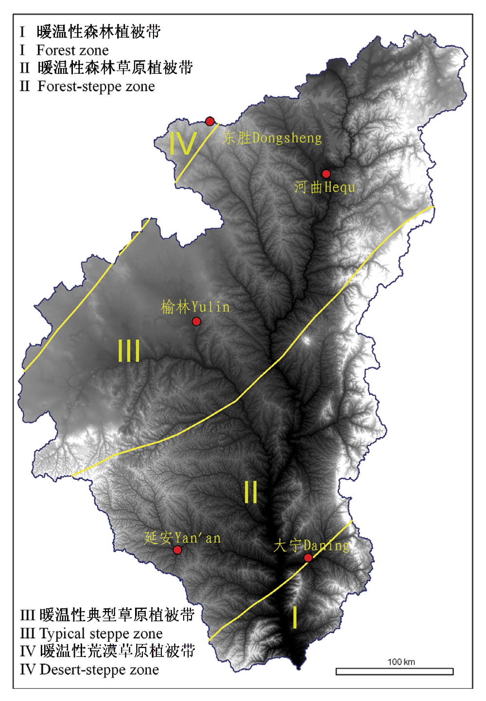
图1 河龙区间生物植被带划分(王义凤, 1991) 背景为研究区100 m DEM, 高程311~2 816 m
Fig. 1 Division of bio-climate zone for the He- Long region (Wang, 1991) The background is 100 m DEM with elevation from 311 to 2 816 m
| 坡向及方位角(°)*范围 Aspect and its ranging | 坡度 Slope (°) | 坡型 Slope profile | |
|---|---|---|---|
| 地面实际坡度 The actual ground slope | 100 m DEM生成坡度** Slope generated from 100 m DEM | ||
| 东北向Northeast: 23~67 | 25 | 6.99 | 凸型坡 Convex slope (DEM单元格曲率≥0 The curvature of grid equal or greater than 0) 凹型坡 Concave slope (DEM单元格曲率<0 The curvature of grid less than 0) |
| 北向坡North: 338~360; 0~22 | 28 | 11.5 | |
| 西北向Northwest: 293~337 | 30 | 13.5 | |
| 东向East: 68~112 | 32 | 15.5 | |
| 西向West: 248~292 | 35 | 18.2 | |
| 东南向Southeast: 113~157 | 38 | 20.5 | |
| 南向South: 158~202 | 40 | 21.5 | |
| 西南向Southwest: 203~247 | 45 | 23.0 | |
表1 坡向、坡度和坡型级别划分
Table 1 Classes of aspect, slope and slope profile
| 坡向及方位角(°)*范围 Aspect and its ranging | 坡度 Slope (°) | 坡型 Slope profile | |
|---|---|---|---|
| 地面实际坡度 The actual ground slope | 100 m DEM生成坡度** Slope generated from 100 m DEM | ||
| 东北向Northeast: 23~67 | 25 | 6.99 | 凸型坡 Convex slope (DEM单元格曲率≥0 The curvature of grid equal or greater than 0) 凹型坡 Concave slope (DEM单元格曲率<0 The curvature of grid less than 0) |
| 北向坡North: 338~360; 0~22 | 28 | 11.5 | |
| 西北向Northwest: 293~337 | 30 | 13.5 | |
| 东向East: 68~112 | 32 | 15.5 | |
| 西向West: 248~292 | 35 | 18.2 | |
| 东南向Southeast: 113~157 | 38 | 20.5 | |
| 南向South: 158~202 | 40 | 21.5 | |
| 西南向Southwest: 203~247 | 45 | 23.0 | |
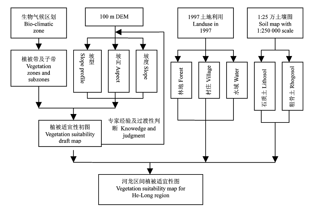
图2 基于DEM 和专家经验的植被适宜性制图流程
Fig. 2 Flowchart of vegetation suitability mapping based on the 100 m DEM and vegetation distribution concepts
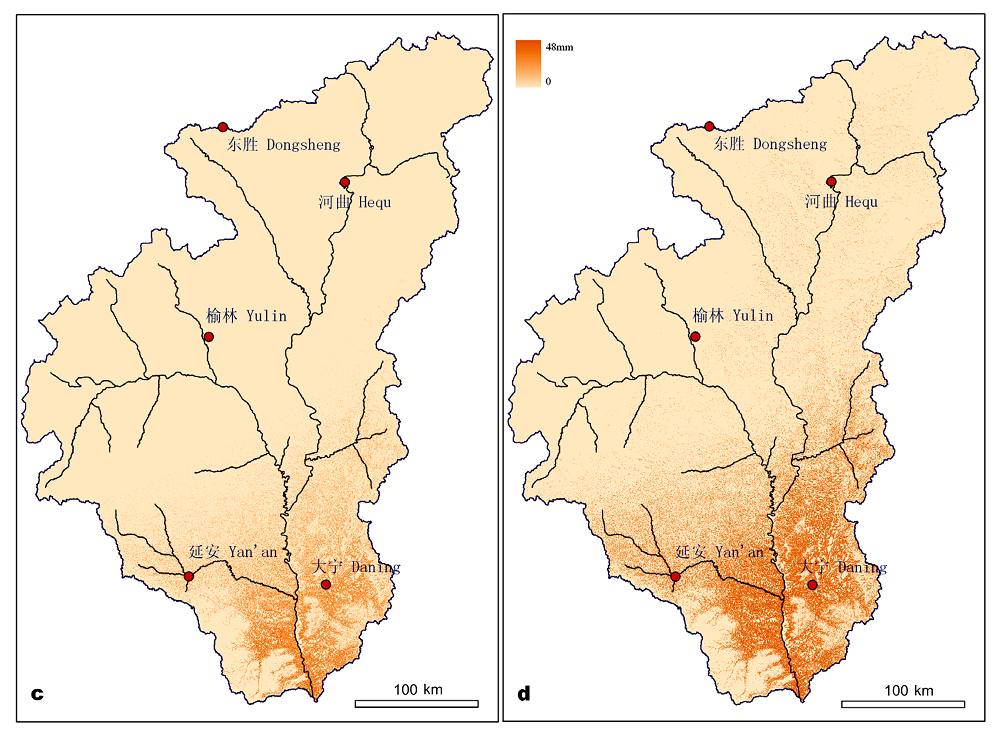
图3 未来植树造林的情景模拟及产水减少分布格局 a: 情景模拟1——适宜区Scenario1―plantation in high suitable area b: 情景模拟2——适宜和次适宜区Scenario 2―plantation in high and moderate suitable area c: 情景模拟1中产水减少分布Water reduction estimation for scenario 1 d: 情景模拟2中产水减少分布Water reduction estimation for scenario 2
Fig. 3 Two plantation scenarios in the region and the water reduction spatial distribution
| w | η |
|---|---|
| 1.61 | 0.8 ≤ γ |
| 0.45 | 0.25≤γ < 0.8 |
| 0.1 | γ < 0.25 |
表2 流域下垫面优化参数值的选用规则
Table 2 The using criteria of parameter w in the catchments
| w | η |
|---|---|
| 1.61 | 0.8 ≤ γ |
| 0.45 | 0.25≤γ < 0.8 |
| 0.1 | γ < 0.25 |
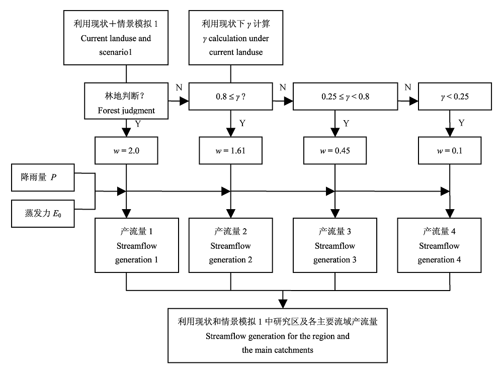
图4 利用现状和情景模拟1下估算产流流程 P: 降雨量Precipitation E0: 蒸发力The potential evaportranspiration w: 相应河龙区间不同土地覆盖特征的下垫面参数The parameter corresponding to the different land covers in He-Long region γ: 100 m DEM每个栅格单元相应的下垫面参数The calculated parameter value in corresponds with individual pixel with 100 m DEM in this paper
Fig. 4 Flowchart of streamflow generation under the current land use and scenario 1
| [1] | Brown AE, Zhang L, McMahon TA, Western AW, Vertessy RA (2005). A review of paired catchment studies for determining changes in water yield resulting from alteration in vegetation. Journal of Hydrology, 310,28-61. |
| [2] | Budyko MI (1974). Climate and Life. Academic Press, San Diego, USA, 508. |
| [3] | Calder IR (1999). The Blue Revolution―Land Use and Integrated Water Resources Management. Earthscan Publications, London. |
| [4] | Chen YM (陈云明), Liang YM (梁一民), Cheng JM (程积民) (2002). The zonal character of vegetation construction on Loess Plateau. Acta Phytoecologica Sinica (植物生态学报), 26,339-345. (in Chinese with English abstract) |
| [5] | Day FP, Monk CD (1974). Vegetation patterns on a southern Appalachian watershed. Ecology, 55,1064-1074. |
| [6] | Huang MB (黄明斌), Kang SZ (康绍忠), Li YS (李玉山) (1999). A comparison of hydrological behaviors of forest and grassland watersheds in gully region of the Loess Plateau. Journal of Natural Resources (自然资源学报), 14,226-231. (in Chinese with English abstract) |
| [7] | Huang MB, Zhang L, Gallichand J (2003). Runoff responses to afforestation in a watershed of the Loess Plateau, China. Hydrological Processes, 17,2599-2609. |
| [8] | Jiang DS (蒋定生), Liu MM (刘梅梅), Huang GJ (黄国俊) (1987). An initial approach to the redistribution laws of precipitation on convex and concave hill slopes. Bulletin of Soil and Water Conservation ( 水土保持通报), 1,45-50. (in Chinese with English abstract) |
| [9] | Jing K (景可), Shen YC (申元村) (2001). The serious problems urgently needing solving in ecological construction in the Loess Plateau. Soil and Water Conservation in China (中国水土保持), 2,12-13. (in Chinese) |
| [10] | Jing K (景可), Shen YC (申元村) (2002). The effect of soil conservation on surface runoff in the Loess Plateau in the future. Soil and Water Conservation in China (中国水土保持), 1,12-14. (in Chinese) |
| [11] | Li M (李勉), Yao WY (姚文艺), Chen JN (陈江南), Ding WF (丁文峰), Yang JF (杨剑锋), Li L (李莉), Yang CX (杨春霞) (2005). Experimental study on the effect of different grass coverages on the overland flow velocity. Transaction of the Chinese Society of Agricultural Engineering (农业工程学报), 21(12),43-47. (in Chinese with English abstract) |
| [12] | Lian G (连纲), Guo XD (郭旭东), Fu BJ (傅伯杰), Hu CX (虎陈霞) (2006). Spatial variability of bulk density and soil water in a small catchment of the Loess Plateau. Acta Ecologica Sinica (生态学报), 26,647-654. (in Chinese with English abstract) |
| [13] | Liu CM (刘昌明), Zhong JX (钟俊襄) (1978). The effect of forest on stream flow in the Loess Plateau. Acta Geographica Sinica (地理学报), 33,112-126. (in Chinese with English abstract) |
| [14] | Oyebande L (1988). Effects of tropical forests on water yield. In: Reynold ERC, Thompson FB eds.Forests, Climate, and Hydrology Regional Impact. Kefford Press, Singapore. |
| [15] | Pan CZ (潘成忠), Shangguan ZP (上官周平) (2004). Spatial variability of soil moisture, nutrients, and productivity on slopeland in loessial semiarid region. Chinese Journal of Applied Ecology (应用生态学报), 15,2061-2066. (in Chinese with English abstract) |
| [16] | Pan CZ (潘成忠), Shangguan ZP (上官周平) (2005). Generation mechanism of woodland runoff and sediment on Loess Plateau under hypo-rainfall ―A case study of artificial P. tabulaeformis and secondary natural P. dadidiana stands. Chinese Journal of Applied Ecology (应用生态学报), 16,1597-1602. (in Chinese with English abstract) |
| [17] | Pike JG (1964). The estimation of annual runoff from meteorological data in a tropical climate. Journal of Hydrology, 2,116-123. |
| [18] | Tan Y (谭勇), Wang CR (王长如), Liang ZS (梁宗锁), Du F (杜峰) (2006). Measures for forest and grass vegetation construction in semi-arid areas on the Loess Platteau. Acta Prataculturae Sinica (草业学报), 15(4),4-11. (in Chinese with English abstract) |
| [19] | Tang KL (唐克丽), Zhang KL (张科利), Lei AL (雷阿林) (1998). The threshold study and demonstration for the slope degree of converting slope farming land in the loess hilly gully region, China. Chinese Science Bulletin (科学通报), 43,200-203. (in Chinese with English abstract) |
| [20] | Wang YF (王义凤) (1991). The Vegetation Resources and Utilization in the Loess Plateau(黄土高原地区植被资源及其合理利用). Chinese Science and Technology Press,Beijing. (in Chinese) |
| [21] | Wu QX (吴钦孝), Yang WZ (杨文治) (1998). Vegetation Construction and Sustainable Development of Loess Plateau (黄土高原植被建设与持续发展). Science Press,Beijing. (in Chinese) |
| [22] | Xu JH (徐建华), Wang L (王玲) (2003). Analysis on water demand for vegetation rehabilitation of the Loess Plateau. Yellow River(人民黄河), 25(1),13-15. (in Chinese) |
| [23] | Yang QY (杨勤业), Yuan BY (袁宝印) (1991). Natural Environment and Its Change of the Loess Plateau (黄土高原地区自然环境及其演变). Science Press,Beijing. (in Chinese) |
| [24] | Yang WZ (杨文治), Shao MA (邵明安) (2000). Research on Soil Water of the Loess Plateau (黄土高原土壤水分研究). Science Press,Beijing. (in Chinese) |
| [25] | Zhang L, Dawes WR, Walker GR (2001). Response of mean annual evapotranspiration to vegetation changes at catchment scale. Water Resources Research, 37,701-708. |
| [26] | Zhang XP (张晓萍), Dong BR (董冰让), Li R (李锐), Yang QK (杨勤科) (2007). Study of land use and forest cover pattern change in Hekou-Longmen section of the Middle Reaches of Yellow River. Journal of Soil and Water Conservation (水土保持学报), 21(5),163-166. (in Chinese with English abstract) |
| [27] | Zhang XP, Zhang L, McVicar TR, Van Niel TG, Li LT, Li R, Yang QK, Liang W (2008). Modelling the impact of afforestation on average annual streamflow in the Loess Plateau, China. Hydrological Processes, 22,1996-2004. |
| [28] | Zhao HY (赵鸿雁), Wu QX (吴钦孝) (2001). Studies on streamflow and sediment yield in small catchment covered artificial Chinese pine stand in Loess Plateau. Progress in Natural Science (自然科学进展), 11,829-834. (in Chinese with English abstract) |
| [29] | Zhou GS (周广胜), Zhang XS (张新时) (1996). Study on Chinese climate-vegetation relationship. Acta Phytoecologica Sinica (植物生态学报), 20,113-119. (in Chinese with English abstract) |
| [30] | Zou HY (邹厚远) (2000). A study of correlation between vegetation division and construction of forest and grasslands in Loess Plateau of Northern Shaanxi. Research of Soil and Water Conservation (水土保持研究), 7(2),96-101. (in Chinese with English abstract) |
| [1] | 吴茹茹, 刘美珍, 谷仙, 常馨月, 郭立月, 蒋高明, 祁如意. 气候变化对巨柏适宜生境分布的潜在影响和预测[J]. 植物生态学报, 2024, 48(4): 445-458. |
| [2] | 郭敏, 罗林, 梁进, 王彦杰, 赵春章. 冻融变化对西南亚高山森林优势种云杉和华西箭竹根区土壤理化性质与酶活性的影响[J]. 植物生态学报, 2023, 47(6): 882-894. |
| [3] | 陈奕竹, 郎伟光, 陈效逑. 中国北方树木秋季物候的过程模拟及其区域分异归因[J]. 植物生态学报, 2022, 46(7): 753-765. |
| [4] | 贾宁霞, 郭柯, 宋创业, 刘长成. 植被制图色彩和符号设计原则与全国植被图图例方案[J]. 植物生态学报, 2021, 45(8): 809-817. |
| [5] | 魏春雪, 杨璐, 汪金松, 杨家明, 史嘉炜, 田大栓, 周青平, 牛书丽. 实验增温对陆地生态系统根系生物量的影响[J]. 植物生态学报, 2021, 45(11): 1203-1212. |
| [6] | 闫涵, 张云玲, 马松梅, 王春成, 张丹. 黑果枸杞在新疆的适宜分布模拟与局部环境适应性分化[J]. 植物生态学报, 2021, 45(11): 1221-1230. |
| [7] | 朱彪, 陈迎. 陆地生态系统野外增温控制实验的技术与方法[J]. 植物生态学报, 2020, 44(4): 330-339. |
| [8] | 李旭, 吴婷, 程严, 谭钠丹, 蒋芬, 刘世忠, 褚国伟, 孟泽, 刘菊秀. 南亚热带常绿阔叶林4个树种对增温的生理生态适应能力比较[J]. 植物生态学报, 2020, 44(12): 1203-1214. |
| [9] | 闫鹏飞, 展鹏飞, 肖德荣, 王燚, 余瑞, 刘振亚, 王行. 模拟增温及分解界面对茭草凋落物分解速率及叶际微生物结构和功能的影响[J]. 植物生态学报, 2019, 43(2): 107-118. |
| [10] | 宋小艳, 王根绪, 冉飞, 杨燕, 张莉, 肖瑶. 东北大兴安岭演替初期泰加林灌草层典型植物开花物候与生长对模拟暖干化气候的响应[J]. 植物生态学报, 2018, 42(5): 539-549. |
| [11] | 刘晓, 戚超, 闫艺兰, 袁国富. 不同生态系统水分利用效率指标在黄土高原半干旱草地应用的适宜性评价[J]. 植物生态学报, 2017, 41(5): 497-505. |
| [12] | 王芑丹, 杨温馨, 黄洁钰, 徐昆, 王佩. 灌丛化的蒸散耗水效应数值模拟研究——以内蒙古灌丛化草原为例[J]. 植物生态学报, 2017, 41(3): 348-358. |
| [13] | 管超, 张鹏, 李新荣. 腾格里沙漠东南缘生物结皮土壤呼吸对水热因子变化的响应[J]. 植物生态学报, 2017, 41(3): 301-310. |
| [14] | 陈定帅, 董正武, 高磊, 陈效民, 彭新华, 司炳成, 赵英. 不同降水条件下科尔沁沙地小叶锦鸡儿和盐蒿的水分利用动态[J]. 植物生态学报, 2017, 41(12): 1262-1272. |
| [15] | 贾彦龙, 李倩茹, 许中旗, 桑卫国. 基于CO2FIX模型的华北落叶松人工林碳循环过程[J]. 植物生态学报, 2016, 40(4): 405-415. |
| 阅读次数 | ||||||
|
全文 |
|
|||||
|
摘要 |
|
|||||
Copyright © 2022 版权所有 《植物生态学报》编辑部
地址: 北京香山南辛村20号, 邮编: 100093
Tel.: 010-62836134, 62836138; Fax: 010-82599431; E-mail: apes@ibcas.ac.cn, cjpe@ibcas.ac.cn
备案号: 京ICP备16067583号-19