
植物生态学报 ›› 2013, Vol. 37 ›› Issue (1): 1-17.DOI: 10.3724/SP.J.1258.2013.00001 cstr: 32100.14.SP.J.1258.2013.00001
• 研究论文 • 下一篇
刘苏峡1,*( ), 邢博1,3, 袁国富2, 莫兴国1, 林忠辉1
收稿日期:2012-04-10
接受日期:2012-08-20
出版日期:2013-04-10
发布日期:2013-01-15
作者简介:*E-mail:liusx@igsnrr.ac.cn基金资助:
LIU Su-Xia1,*(), XING Bo1,3, YUAN Guo-Fu2, MO Xing-Guo1, LIN Zhong-Hui1
Received:2012-04-10
Accepted:2012-08-20
Online:2013-04-10
Published:2013-01-15
摘要:
根层与表层土壤水分的关系, 是由较易获取的表层土壤水分信息去探讨较难获取的深层土壤水分信息的重要桥梁。已有的根层与表层土壤水分关系(简称根表关系)大都基于一种作物或一种生态系统。该文根据我国生态系统研究网络, 包括森林、草地、农田、荒漠和沼泽生态系统的31个站点109个观测场2006年全年3437对根层和表层土壤水分数据, 研究了根表关系以及生态系统、土壤质地、湿润度、植被、土壤厚度和土壤水分量级对根表关系的影响。研究发现, 表层和根层土壤水分存在着线性关系。森林和沼泽的根层与表层土壤水分相关程度较高, 无论是率定段还是校核段, 其决定系数(R2)均大于0.79。农田和草地生态系统的率定段相关性较好, R 2均大于0.80, 校核段相关性稍弱, R 2分别为0.70和0.50。荒漠生态系统的相关关系最弱, 率定段的R2为0.62, 校核段的R2为0.49。土壤质地和生态系统因素对根表关系的影响较为一致。半湿润带、半干旱带和干旱带的根表关系空间分异性最强; 十分湿润带的根表关系与壤土和森林生态系统的根表关系相对应。湿润带内部的根表关系较为一致。将植被对根表关系的影响分为4类, 前两类为根表关系微弱的植被, 由植被本身或者植被以外的地域因素导致, 不适合用根表关系去由表层推算根层土壤水分; 后两类为根表关系良好植被, 区别为服从和不服从关系总线, 可分别用各自的根表关系或者关系总线从表层土壤水分获取根层土壤水分。表层土壤水分与0-20、0-30、……、0-100 cm土层的土壤水分均分别具有较好的相关关系, 但二者的相关性随土层厚度的增加而降低。不过, 即使是土层厚度抵及100 cm, R 2仍能维持在0.79。通过将土壤水分分别除以所有观测数据的最大值(“标甲”法)和各个生态系统数据的最大值(“标乙”法), 发现根表关系不受土壤水分量级本身的影响。
刘苏峡, 邢博, 袁国富, 莫兴国, 林忠辉. 中国根层与表层土壤水分关系分析. 植物生态学报, 2013, 37(1): 1-17. DOI: 10.3724/SP.J.1258.2013.00001
LIU Su-Xia, XING Bo, YUAN Guo-Fu, MO Xing-Guo, LIN Zhong-Hui. Relationship analysis between soil moisture in root zone and top-most layer in China. Chinese Journal of Plant Ecology, 2013, 37(1): 1-17. DOI: 10.3724/SP.J.1258.2013.00001
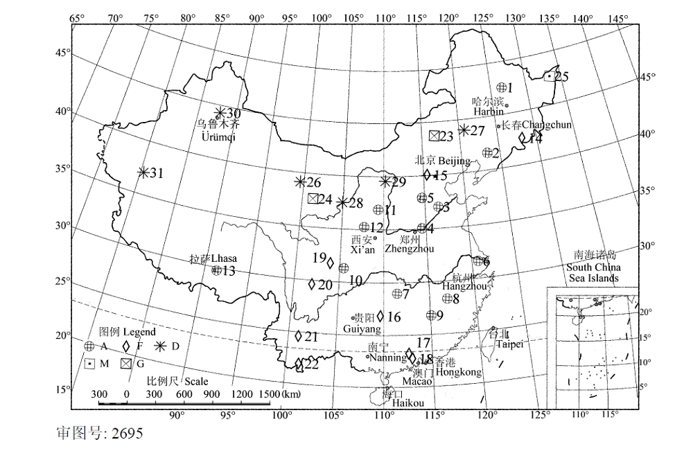
图1 不同生态系统各观测站点的地理位置。各站点以序号表示, 观测站代号及名称见表1。A, 农业生态系统; D, 荒漠生态系统; F, 森林生态系统; G, 草地生态系统; M, 沼泽生态系统。
Fig. 1 Locations of the China Ecosystem Research Network stations in different ecosystems. Every station is represented by order numbers, the order number and name of the stations are shown in Table 1. A, agricultural ecosystem; D, desert ecosystem; F, forest ecosystem; G, grass ecosystem; M, mire ecosystem.
| 生态系统 Ecosystem | 序号 No. | 观测站名 Observation station name | 经度 Longitude (E) | 纬度 Latitude (N) | 观测场数 Number of observation fields | 多年平均年降水量Average annual precipitation (mm) | 土壤质地 Soil texture | 主要土地覆被类型 Major land cover type |
|---|---|---|---|---|---|---|---|---|
| 农田生态系统 Agriculture ecosystem | 1 | 海伦 Hailun | 126°38′ | 47°26′ | 6 | 550 | 黏土 Clay | 大豆、狗尾草、小麦 Glycine max, Setaria faberii, Triticum aestivum |
| 2 | 沈阳 Shenyang | 123°24′ | 41°31′ | 1 | 675 | 壤土 Loam | 玉米 Zea may | |
| 3 | 禹城 Yucheng | 116°36′ | 36°57′ | 2 | 610 | 壤土 Loam | 小麦-玉米、草 Triticum aestivum-Zea may, grass | |
| 4 | 封丘 Fengqiu | 114°32′ | 35°01′ | 5 | 605 | 砂壤土 Sandy loam | 小麦-玉米、荒草 Triticum aestivum-Zea may, grass | |
| 5 | 栾城 Luancheng | 114°41′ | 37°53′ | 2 | 537 | 砂壤土 Sandy loam | 小麦-玉米、草 Triticum aestivum-Zea may, grass | |
| 6 | 常熟 Changshu | 120°42′ | 31°33′ | 2 | 1038 | 壤土 Loam | 小麦-水稻、草 Triticum aestivum-Oryza sativa, grass | |
| 7 | 桃源 Taoyuan | 111°27′ | 28°55′ | 8 | 1450 | 黏壤土 Clay loam | 自然植被、水稻、油菜-红薯-萝卜、茶、柑橘 Natural vegetation, Oryza sativa, Brassica chinensis-Ipomoea batatas-Raphanus sativus, Camellia sinensis, Citrus reticulata | |
| 8 | 鹰潭 Yingtan | 116°55′ | 28°15′ | 3 | 1795 | 黏土 Clay | 花生、水稻、草 Arachis hypogaea, Oryza sativa, grass | |
| 9 | 千烟州 Qianyanzhou | 115°04′ | 26°45′ | 2 | 1542 | 壤土 Loam | 柑橘 Citrus reticulata | |
| 10 | 盐亭 Yanting | 105°27′ | 31°16′ | 4 | 826 | 黏壤土 Clay loam | 小麦-玉米、油菜、草 Triticum aestivum-Zea mays, Brassica chinensis, grass | |
| 11 | 安塞 Ansai | 109°19′ | 36°51′ | 6 | 500 | 壤土 Loam | 自然荒草、玉米、谷子 Natural grass, Zea mays, Pennisetum glaucum | |
| 12 | 长武 Changwu | 107°40′ | 35°12′ | 4 | 584 | 壤土 Loam | 冬小麦、草 Triticum aestivum, grass | |
| 13 | 拉萨 Lhasa | 91°21′ | 29°41′ | 2 | 400 | 砂壤土 Sandy loam | 春青稞、草 Hordeum vulgare, grass | |
| 森林生态系统 Forest ecosystem | 14 | 长白山 Changbaishan | 128°06′ | 42°24′ | 2 | 713 | 壤土 Loam | |
| 15 | 北京 Beijing | 115°26′ | 40°00′ | 6 | 595 | 壤土 Loam | ||
| 16 | 会同 Huitong | 109°35′ | 26°47′ | 3 | 1300 | 黏土 Clay | 人工林、常绿阔叶林 Plantation, evergreen broad-leaved forest | |
| 17 | 鼎湖山 Dinghushan | 112°32′ | 23°10′ | 3 | 1956 | 壤土 Loam | 季风林、马尾松林、针阔混交林 Monsoon forest, Pinus massoniana forest, mixed wood of needle leaf forest and broad leaf forest | |
| 18 | 鹤山 Heshan | 112°54′ | 22°41′ | 2 | 1801 | 壤土 Loam | ||
| 19 | 茂县 Maoxian | 103°54′ | 31°41′ | 3 | 825 | 壤土 Loam | ||
| 生态系统 Ecosystem | 序号 No. | 观测站名 Observation station name | 经度 Longitude (E) | 纬度 Latitude (N) | 观测场数 Number of observation fields | 多年平均年降水量Average annual precipitation (mm) | 土壤质地 Soil texture | 主要土地覆被类型 Major land cover type |
| 20 | 贡嘎山 Gonggashan | 102°00′ | 29°34′ | 2 | 1300 | 砂土 Sandy soil | 峨嵋冷杉成熟林 Mature forest of Abies fabr in E’mei | |
| 21 | 哀牢山 Ailaoshan | 101°01′ | 24°32′ | 4 | 1931 | 壤土 Loam | 湿性常绿阔叶林、山顶苔藓矮林、滇山杨次生林、热带橡胶林 Moisture evergreen broad-leaved forest, summit mossy dwarf forest, secondary forest of Populus davidiana spp., tropical forest of Hevea brasiliensis | |
| 22 | 西双版纳 Xishuangbanna | 101°16′ | 21°54′ | 9 | 1557 | 黏壤土砂壤土 Clay loam and sandy loam | 热带次生林、热带人工雨林、石灰山季雨林、鸡血藤热带次生林、热带季雨林 Tropical secondary forest, artificial tropical rainforest, monsoon rain forest over limestone, tropical secondary forest of Millettia reticulata, tropical monsoon rainforest | |
| 草地生态系统 Grass ecosystem | 23 | 内蒙古 Nei Mongol | 116°42′ | 43°38′ | 1 | 255 | 砂壤土 Sandy loam | 羊草 Leymus chinensis |
| 24 | 海北 Haibei | 101°19′ | 37°37′ | 1 | 590 | 砂土 Sandy soil | 矮蒿草甸 Artemisia lancea meadow | |
| 沼泽生态系统 Mire ecosystem | 25 | 三江 Sanjiang | 133°31′ | 47°35′ | 4 | 600 | 草甸白浆土Meadow soil with white pulp | 大豆、毛果薹草、小叶章 Glycine max, Carex miyabei var. maopengensis, Calamagrostis angustifolia |
| 荒漠生态系统 Dessert ecosystem | 26 | 临泽 Linze | 99°35′ | 39°04′ | 3 | 117 | 风沙土 Aeolian soil | 玉米、枣 Zea mays, Ziziphus jujuba |
| 27 | 奈曼 Naiman | 120°42′ | 43°55′ | 4 | 400 | 砂壤土 Sandy loam | 春小麦-荞麦、狗尾草等 Triticum aestivum-Fagopyrum esculentum, Faberii herrm et al. | |
| 28 | 沙坡头 Shapotou | 104°57′ | 37°27′ | 4 | 186 | 风沙土 Aeolian soil | 玉米、天然植被 Zea mays, natural vegetation | |
| 29 | 鄂尔多斯 Ordos | 110°11′ | 39°29′ | 2 | 250 | 风沙土 Aeolian soil | 油蒿灌丛 Arternisia ordosica shrub | |
| 30 | 阜康 Fukang | 87°55′ | 44°17′ | 3 | 164 | 风沙土 Aeolian soil | 棉花、梭梭和沙蒿 Gossypium spp., Herba cistranches, Artemisia ordosica | |
| 31 | 策勒 Cele | 80°43′ | 37°00′ | 6 | 34 | 风沙土 Aeolian soil | 骆驼刺、花花柴、芦苇、柽柳及零星分节的一年生植物、棉花 Alhagi gagneb, Karelinia caspia, Phragmites australis, Tamarix ramosissima, some therophyte, Gossypium spp. |
表1 各观测站信息汇总
Table 1 Information collection for all of the observation stations
| 生态系统 Ecosystem | 序号 No. | 观测站名 Observation station name | 经度 Longitude (E) | 纬度 Latitude (N) | 观测场数 Number of observation fields | 多年平均年降水量Average annual precipitation (mm) | 土壤质地 Soil texture | 主要土地覆被类型 Major land cover type |
|---|---|---|---|---|---|---|---|---|
| 农田生态系统 Agriculture ecosystem | 1 | 海伦 Hailun | 126°38′ | 47°26′ | 6 | 550 | 黏土 Clay | 大豆、狗尾草、小麦 Glycine max, Setaria faberii, Triticum aestivum |
| 2 | 沈阳 Shenyang | 123°24′ | 41°31′ | 1 | 675 | 壤土 Loam | 玉米 Zea may | |
| 3 | 禹城 Yucheng | 116°36′ | 36°57′ | 2 | 610 | 壤土 Loam | 小麦-玉米、草 Triticum aestivum-Zea may, grass | |
| 4 | 封丘 Fengqiu | 114°32′ | 35°01′ | 5 | 605 | 砂壤土 Sandy loam | 小麦-玉米、荒草 Triticum aestivum-Zea may, grass | |
| 5 | 栾城 Luancheng | 114°41′ | 37°53′ | 2 | 537 | 砂壤土 Sandy loam | 小麦-玉米、草 Triticum aestivum-Zea may, grass | |
| 6 | 常熟 Changshu | 120°42′ | 31°33′ | 2 | 1038 | 壤土 Loam | 小麦-水稻、草 Triticum aestivum-Oryza sativa, grass | |
| 7 | 桃源 Taoyuan | 111°27′ | 28°55′ | 8 | 1450 | 黏壤土 Clay loam | 自然植被、水稻、油菜-红薯-萝卜、茶、柑橘 Natural vegetation, Oryza sativa, Brassica chinensis-Ipomoea batatas-Raphanus sativus, Camellia sinensis, Citrus reticulata | |
| 8 | 鹰潭 Yingtan | 116°55′ | 28°15′ | 3 | 1795 | 黏土 Clay | 花生、水稻、草 Arachis hypogaea, Oryza sativa, grass | |
| 9 | 千烟州 Qianyanzhou | 115°04′ | 26°45′ | 2 | 1542 | 壤土 Loam | 柑橘 Citrus reticulata | |
| 10 | 盐亭 Yanting | 105°27′ | 31°16′ | 4 | 826 | 黏壤土 Clay loam | 小麦-玉米、油菜、草 Triticum aestivum-Zea mays, Brassica chinensis, grass | |
| 11 | 安塞 Ansai | 109°19′ | 36°51′ | 6 | 500 | 壤土 Loam | 自然荒草、玉米、谷子 Natural grass, Zea mays, Pennisetum glaucum | |
| 12 | 长武 Changwu | 107°40′ | 35°12′ | 4 | 584 | 壤土 Loam | 冬小麦、草 Triticum aestivum, grass | |
| 13 | 拉萨 Lhasa | 91°21′ | 29°41′ | 2 | 400 | 砂壤土 Sandy loam | 春青稞、草 Hordeum vulgare, grass | |
| 森林生态系统 Forest ecosystem | 14 | 长白山 Changbaishan | 128°06′ | 42°24′ | 2 | 713 | 壤土 Loam | |
| 15 | 北京 Beijing | 115°26′ | 40°00′ | 6 | 595 | 壤土 Loam | ||
| 16 | 会同 Huitong | 109°35′ | 26°47′ | 3 | 1300 | 黏土 Clay | 人工林、常绿阔叶林 Plantation, evergreen broad-leaved forest | |
| 17 | 鼎湖山 Dinghushan | 112°32′ | 23°10′ | 3 | 1956 | 壤土 Loam | 季风林、马尾松林、针阔混交林 Monsoon forest, Pinus massoniana forest, mixed wood of needle leaf forest and broad leaf forest | |
| 18 | 鹤山 Heshan | 112°54′ | 22°41′ | 2 | 1801 | 壤土 Loam | ||
| 19 | 茂县 Maoxian | 103°54′ | 31°41′ | 3 | 825 | 壤土 Loam | ||
| 生态系统 Ecosystem | 序号 No. | 观测站名 Observation station name | 经度 Longitude (E) | 纬度 Latitude (N) | 观测场数 Number of observation fields | 多年平均年降水量Average annual precipitation (mm) | 土壤质地 Soil texture | 主要土地覆被类型 Major land cover type |
| 20 | 贡嘎山 Gonggashan | 102°00′ | 29°34′ | 2 | 1300 | 砂土 Sandy soil | 峨嵋冷杉成熟林 Mature forest of Abies fabr in E’mei | |
| 21 | 哀牢山 Ailaoshan | 101°01′ | 24°32′ | 4 | 1931 | 壤土 Loam | 湿性常绿阔叶林、山顶苔藓矮林、滇山杨次生林、热带橡胶林 Moisture evergreen broad-leaved forest, summit mossy dwarf forest, secondary forest of Populus davidiana spp., tropical forest of Hevea brasiliensis | |
| 22 | 西双版纳 Xishuangbanna | 101°16′ | 21°54′ | 9 | 1557 | 黏壤土砂壤土 Clay loam and sandy loam | 热带次生林、热带人工雨林、石灰山季雨林、鸡血藤热带次生林、热带季雨林 Tropical secondary forest, artificial tropical rainforest, monsoon rain forest over limestone, tropical secondary forest of Millettia reticulata, tropical monsoon rainforest | |
| 草地生态系统 Grass ecosystem | 23 | 内蒙古 Nei Mongol | 116°42′ | 43°38′ | 1 | 255 | 砂壤土 Sandy loam | 羊草 Leymus chinensis |
| 24 | 海北 Haibei | 101°19′ | 37°37′ | 1 | 590 | 砂土 Sandy soil | 矮蒿草甸 Artemisia lancea meadow | |
| 沼泽生态系统 Mire ecosystem | 25 | 三江 Sanjiang | 133°31′ | 47°35′ | 4 | 600 | 草甸白浆土Meadow soil with white pulp | 大豆、毛果薹草、小叶章 Glycine max, Carex miyabei var. maopengensis, Calamagrostis angustifolia |
| 荒漠生态系统 Dessert ecosystem | 26 | 临泽 Linze | 99°35′ | 39°04′ | 3 | 117 | 风沙土 Aeolian soil | 玉米、枣 Zea mays, Ziziphus jujuba |
| 27 | 奈曼 Naiman | 120°42′ | 43°55′ | 4 | 400 | 砂壤土 Sandy loam | 春小麦-荞麦、狗尾草等 Triticum aestivum-Fagopyrum esculentum, Faberii herrm et al. | |
| 28 | 沙坡头 Shapotou | 104°57′ | 37°27′ | 4 | 186 | 风沙土 Aeolian soil | 玉米、天然植被 Zea mays, natural vegetation | |
| 29 | 鄂尔多斯 Ordos | 110°11′ | 39°29′ | 2 | 250 | 风沙土 Aeolian soil | 油蒿灌丛 Arternisia ordosica shrub | |
| 30 | 阜康 Fukang | 87°55′ | 44°17′ | 3 | 164 | 风沙土 Aeolian soil | 棉花、梭梭和沙蒿 Gossypium spp., Herba cistranches, Artemisia ordosica | |
| 31 | 策勒 Cele | 80°43′ | 37°00′ | 6 | 34 | 风沙土 Aeolian soil | 骆驼刺、花花柴、芦苇、柽柳及零星分节的一年生植物、棉花 Alhagi gagneb, Karelinia caspia, Phragmites australis, Tamarix ramosissima, some therophyte, Gossypium spp. |
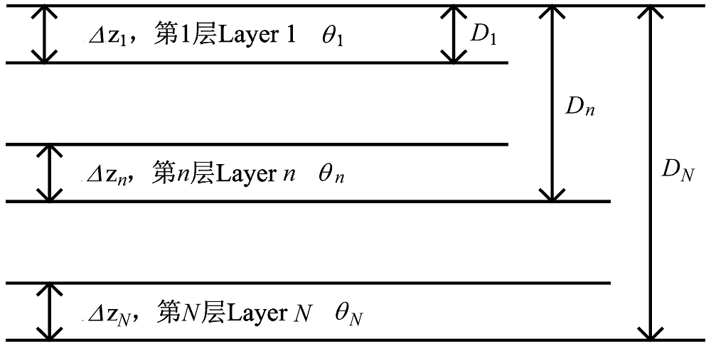
图2 土壤贮水量示意图。 D, 土体厚度; Δz, 观测厚度; θ, 体积含水量。
Fig. 2 Schematic diagram of soil moisture definition. D, thickness of soil; Δz, observation depth; θ, volumetric water content.
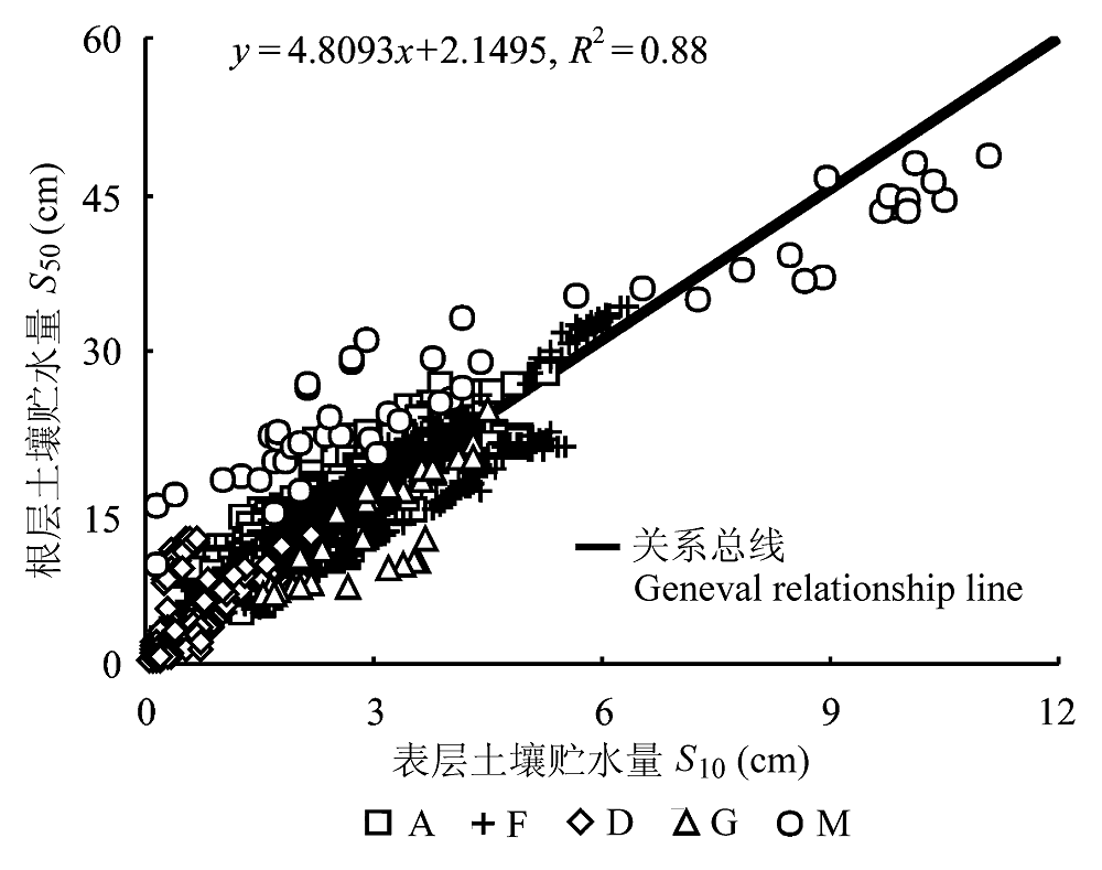
图3 不同生态系统的根表关系。A, 农业生态系统; D, 荒漠生态系统; F, 森林生态系统; G, 草地生态系统; M, 沼泽生态系统。
Fig. 3 Relationship between top-most layer soil moisture (S10) and root zone layer soil moisture (S50) over different ecosystems. A, agricultural ecosystem; D, desert ecosystem; F, forest ecosystem; G, grass ecosystem; M, mire ecosystem.
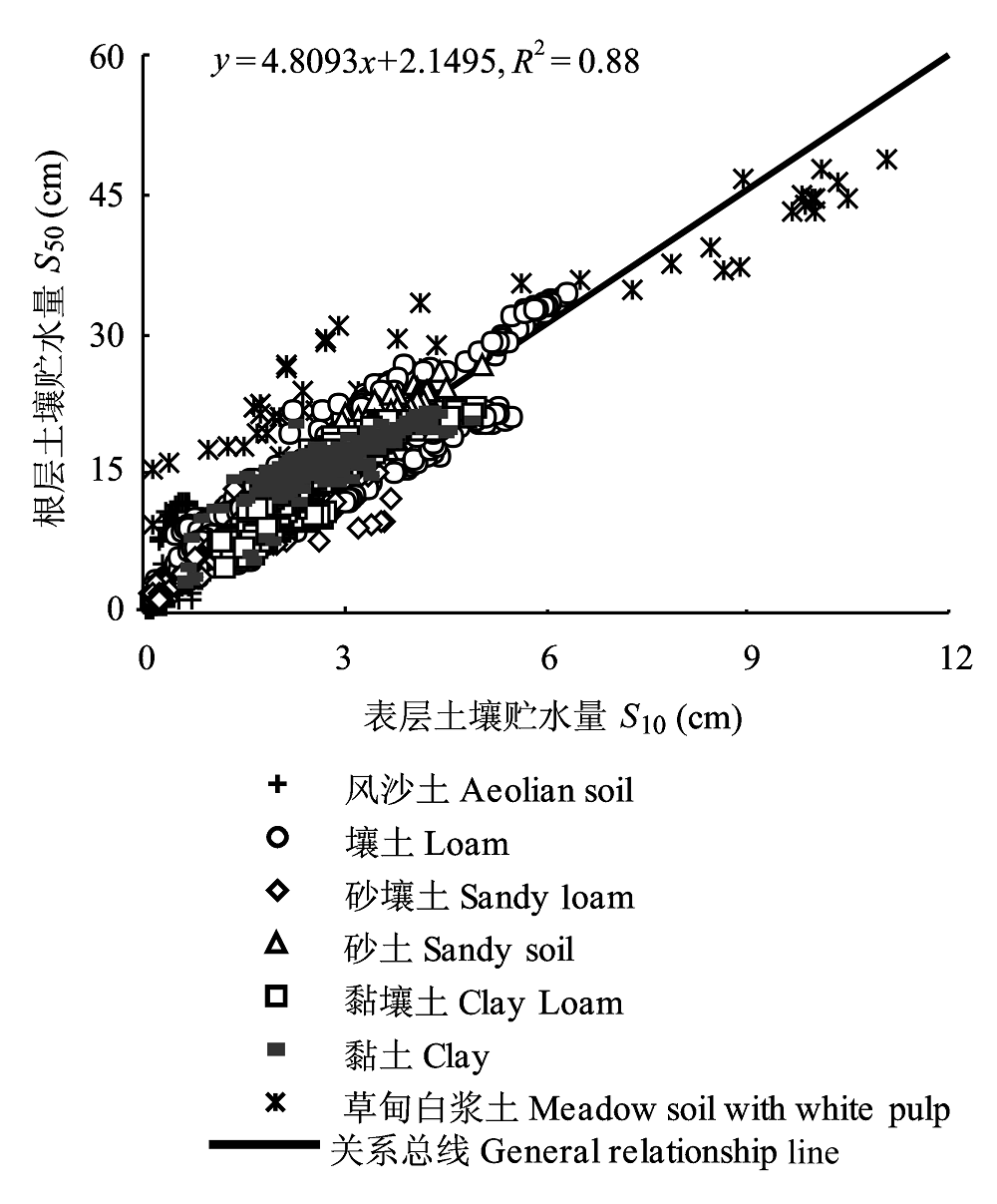
图4 不同土壤类型的根表关系。
Fig. 4 Relationship between top-most layer soil moisture (S10) and root zone layer soil moisture (S50) for different soil types.
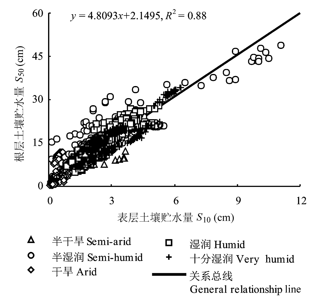
图5 不同湿润区的根表关系。
Fig. 5 Relationship between top-most layer soil moisture (S10) and root zone layer soil moisture (S50) for different humidity zone.
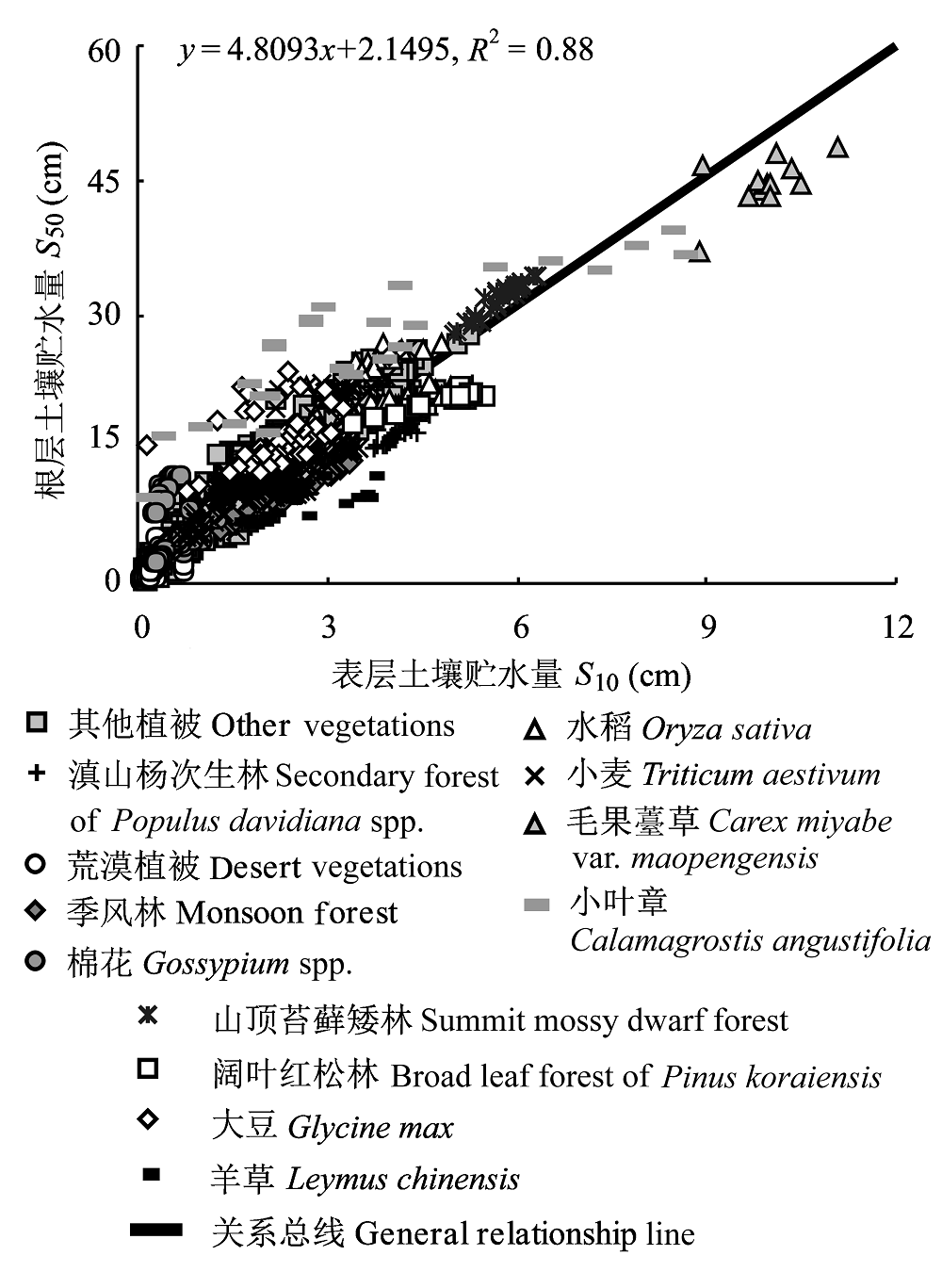
图6 不同植被的根表关系。
Fig. 6 Relationship between top-most layer soil moisture (S10) and root zone layer soil moisture (S50) for different vegetation types.
| 土地覆被类型 Land cover type | n | a | b | R2 |
|---|---|---|---|---|
| 花生 Arachis hypogaea | 12 | 18.997 0 | -24.967 0 | 0.90 |
| 滇山杨次生林 Secondary forest of Populus davidiana spp. | 36 | 5.058 6 | -3.857 5 | 0.87 |
| 油菜 Brassica chinensis | 25 | 6.367 9 | -2.153 6 | 0.95 |
| 荒漠植被 Vegetation in desert | 239 | 4.709 2 | 0.724 5 | 0.40 |
| 1. 奈曼差巴嘎蒿+小叶锦鸡儿 Arternisia halodendron + Caragana microphylia In Naiman | 14 | 3.988 2 | 0.671 6 | 0.27 |
| 2. 奈曼狗尾草+芦苇+地锦 Setaria faberii + Phragmites australis + Parthenocissus semicordata in Naiman | 15 | 3.475 3 | 1.669 4 | 0.33 |
| 3. 鄂尔多斯油蒿灌丛 Arternisia ordosica shrub in Ordos | 21 | 16.995 0 | -3.652 1 | 0.41 |
| 4. 鄂尔多斯气象站周围为油蒿灌丛Arternisia ordosica shrub about Ordos meteorological station | 21 | 8.510 7 | -0.628 7 | 0.14 |
| 5. 临泽红沙蒿、泡泡枣 Artemisia ordosica, Chaenomeles sinensis in Linze | 18 | 10.280 0 | 0.156 1 | 0.76 |
| 6. 沙坡头红卫天然植被 Natural vegetations in Hongwei, Shapotou | 21 | 1.654 7 | 0.508 7 | 0.70 |
| 7. 策勒骆驼刺、柽柳、花花柴和零星分布的草本植物 Alhagi gagneb, Tamarix ramosissima, Kareliniacaspia spp., and some grass in Cele | 36 | 5.946 2 | 0.461 8 | 0.68 |
| 8. 策勒骆驼刺、花花柴、柽柳和部分一年生植物 Alhagi gagneb, Kareliniacaspia spp., Tamarix ramosissima, and some therophyte in Cele | 36 | 7.053 3 | 0.120 0 | 0.61 |
| 9. 策勒骆驼刺、花花柴、芦苇及零星分布的一年生植物 Alhagi gagneb, Kareliniacaspia spp., Phragmites australis and some therophyte in Cele | 36 | 6.892 1 | 0.366 2 | 0.78 |
| 10. 阜康梭梭和沙蒿 Herba cistranches, Artemisia ordosica in Fukang | 22 | 10.010 0 | -0.710 8 | 0.73 |
| 综合观测场植被 Vegetation in integrated observation field | 212 | 5.438 5 | 1.014 3 | 0.95 |
| 季风林 Monsoon forest | 36 | 3.573 5 | 1.372 1 | 0.98 |
| 气象观测场植被 Vegetation in meteorological station | 179 | 5.001 0 | 1.480 3 | 0.92 |
| 热带林 Tropical forest | 180 | 5.118 1 | 1.524 0 | 0.94 |
| 玉米 Zea mays | 344 | 4.896 5 | 1.649 9 | 0.91 |
| 春小麦 Triticum aestivum | 8 | 4.758 0 | 1.773 1 | 0.87 |
| 马尾松林 Pinus massoniana forest | 12 | 4.224 1 | 1.773 2 | 0.99 |
| 针阔混交林 Mixed coniferous forest | 12 | 3.905 1 | 1.802 6 | 0.99 |
| 春青稞 Hordeum vulgare | 13 | 5.002 6 | 1.809 0 | 0.92 |
| 裸地 Bare land | 276 | 5.168 5 | 1.834 6 | 0.79 |
| 草地 Grass land | 585 | 4.955 4 | 1.930 8 | 0.83 |
| 棉花 Gossypium spp. | 130 | 5.014 3 | 2.407 5 | 0.13 |
| 1. 阜康棉花 Gossypium spp. in Fukang | 108 | 5.537 7 | 1.001 1 | 0.82 |
| 2. 策勒棉花 Gossypium spp. in Cele | 22 | 8.394 3 | 6.557 0 | 0.74 |
| 山顶苔藓矮林 Summit mossy dwarf forest | 36 | 5.111 5 | 2.464 5 | 0.92 |
| 荞麦 Fagopyrum esculentum | 7 | 4.686 6 | 2.656 8 | 0.97 |
| 小麦 Triticum aestivum | 448 | 4.554 7 | 3.018 2 | 0.68 |
| 哀牢中山湿性常绿阔叶林 Evergreen broad leaf forest in Ailao’s humid mountains | 36 | 5.072 1 | 3.275 3 | 0.88 |
| 茶、柑橘 Camellia sinensis, Citrus reticulata | 106 | 4.175 3 | 3.760 5 | 0.94 |
| 谷子 Pennisetum glaucum | 36 | 3.045 2 | 4.107 4 | 0.62 |
| 桃源自然恢复和退化植被 Natural fields | 72 | 4.066 5 | 4.143 7 | 0.89 |
| 羊草 Leymus chinensis | 16 | 1.713 4 | 4.522 4 | 0.50 |
| 会同常绿阔叶林 Evergreen broad leaf forest in Huitong | 33 | 4.025 1 | 4.578 4 | 0.96 |
| 石灰山季雨林 Monsoon rain forest over limestone | 36 | 3.534 9 | 4.849 2 | 0.92 |
| 红薯 Ipomoea batatas | 15 | 3.457 9 | 6.031 3 | 0.83 |
| 鸡血藤热带次生林 Tropical secondary forest of Millettia extensa | 36 | 3.180 2 | 6.995 9 | 0.97 |
| 杉木人工林 Plantation forest of Cunninghamia lanceolata | 33 | 3.487 3 | 7.192 7 | 0.97 |
| 曼安热带林 Tropical forest in Man’an | 36 | 3.694 1 | 7.303 0 | 0.97 |
| 萝卜 Raphanus sativus | 6 | 2.251 3 | 9.162 6 | 0.99 |
| 土地覆被类型 Land cover type | n | a | b | R2 |
| 峨眉冷杉成熟林 Matural forest of Abies fabr in E’mei | 17 | 3.559 4 | 9.400 7 | 0.80 |
| 大豆 Glycine max | 75 | 2.577 5 | 10.179 0 | 0.26 |
| 1. 三江沼泽大豆 Glycine max in Sanjiang mire | 13 | 2.396 1 | 15.302 0 | 0.43 |
| 2. 海伦大豆 Glycine max in Hailun | 62 | 3.242 8 | 7.708 7 | 0.75 |
| 阔叶红松林 Broad leaf forest of Pinus koraiensis | 18 | 1.610 1 | 12.580 0 | 0.88 |
| 毛果薹草 Carex miyabei var. maopengensis | 12 | 2.950 3 | 15.291 0 | 0.37 |
| 水稻 Oryza sativa | 37 | 1.482 6 | 15.838 0 | 0.15 |
| 1. 常熟水稻 Oryza sativa in Changshu | 12 | 2.419 4 | 15.542 0 | 0.73 |
| 2. 鹰潭水稻 Oryza sativa in Yingtan | 9 | 1.455 3 | 13.972 0 | 0.97 |
| 3. 桃源水稻 Oryza sativa in Taoyuan | 16 | 1.609 4 | 13.963 0 | 0.89 |
| 小叶章 Calamagrostis angustifolia | 26 | 2.812 6 | 16.485 0 | 0.79 |
表2 不同植被的根表关系最佳拟合线的参数
Table 2 Parameters of best-fitted line between top-most layer and root zone layer soil moisture for different vegetation types
| 土地覆被类型 Land cover type | n | a | b | R2 |
|---|---|---|---|---|
| 花生 Arachis hypogaea | 12 | 18.997 0 | -24.967 0 | 0.90 |
| 滇山杨次生林 Secondary forest of Populus davidiana spp. | 36 | 5.058 6 | -3.857 5 | 0.87 |
| 油菜 Brassica chinensis | 25 | 6.367 9 | -2.153 6 | 0.95 |
| 荒漠植被 Vegetation in desert | 239 | 4.709 2 | 0.724 5 | 0.40 |
| 1. 奈曼差巴嘎蒿+小叶锦鸡儿 Arternisia halodendron + Caragana microphylia In Naiman | 14 | 3.988 2 | 0.671 6 | 0.27 |
| 2. 奈曼狗尾草+芦苇+地锦 Setaria faberii + Phragmites australis + Parthenocissus semicordata in Naiman | 15 | 3.475 3 | 1.669 4 | 0.33 |
| 3. 鄂尔多斯油蒿灌丛 Arternisia ordosica shrub in Ordos | 21 | 16.995 0 | -3.652 1 | 0.41 |
| 4. 鄂尔多斯气象站周围为油蒿灌丛Arternisia ordosica shrub about Ordos meteorological station | 21 | 8.510 7 | -0.628 7 | 0.14 |
| 5. 临泽红沙蒿、泡泡枣 Artemisia ordosica, Chaenomeles sinensis in Linze | 18 | 10.280 0 | 0.156 1 | 0.76 |
| 6. 沙坡头红卫天然植被 Natural vegetations in Hongwei, Shapotou | 21 | 1.654 7 | 0.508 7 | 0.70 |
| 7. 策勒骆驼刺、柽柳、花花柴和零星分布的草本植物 Alhagi gagneb, Tamarix ramosissima, Kareliniacaspia spp., and some grass in Cele | 36 | 5.946 2 | 0.461 8 | 0.68 |
| 8. 策勒骆驼刺、花花柴、柽柳和部分一年生植物 Alhagi gagneb, Kareliniacaspia spp., Tamarix ramosissima, and some therophyte in Cele | 36 | 7.053 3 | 0.120 0 | 0.61 |
| 9. 策勒骆驼刺、花花柴、芦苇及零星分布的一年生植物 Alhagi gagneb, Kareliniacaspia spp., Phragmites australis and some therophyte in Cele | 36 | 6.892 1 | 0.366 2 | 0.78 |
| 10. 阜康梭梭和沙蒿 Herba cistranches, Artemisia ordosica in Fukang | 22 | 10.010 0 | -0.710 8 | 0.73 |
| 综合观测场植被 Vegetation in integrated observation field | 212 | 5.438 5 | 1.014 3 | 0.95 |
| 季风林 Monsoon forest | 36 | 3.573 5 | 1.372 1 | 0.98 |
| 气象观测场植被 Vegetation in meteorological station | 179 | 5.001 0 | 1.480 3 | 0.92 |
| 热带林 Tropical forest | 180 | 5.118 1 | 1.524 0 | 0.94 |
| 玉米 Zea mays | 344 | 4.896 5 | 1.649 9 | 0.91 |
| 春小麦 Triticum aestivum | 8 | 4.758 0 | 1.773 1 | 0.87 |
| 马尾松林 Pinus massoniana forest | 12 | 4.224 1 | 1.773 2 | 0.99 |
| 针阔混交林 Mixed coniferous forest | 12 | 3.905 1 | 1.802 6 | 0.99 |
| 春青稞 Hordeum vulgare | 13 | 5.002 6 | 1.809 0 | 0.92 |
| 裸地 Bare land | 276 | 5.168 5 | 1.834 6 | 0.79 |
| 草地 Grass land | 585 | 4.955 4 | 1.930 8 | 0.83 |
| 棉花 Gossypium spp. | 130 | 5.014 3 | 2.407 5 | 0.13 |
| 1. 阜康棉花 Gossypium spp. in Fukang | 108 | 5.537 7 | 1.001 1 | 0.82 |
| 2. 策勒棉花 Gossypium spp. in Cele | 22 | 8.394 3 | 6.557 0 | 0.74 |
| 山顶苔藓矮林 Summit mossy dwarf forest | 36 | 5.111 5 | 2.464 5 | 0.92 |
| 荞麦 Fagopyrum esculentum | 7 | 4.686 6 | 2.656 8 | 0.97 |
| 小麦 Triticum aestivum | 448 | 4.554 7 | 3.018 2 | 0.68 |
| 哀牢中山湿性常绿阔叶林 Evergreen broad leaf forest in Ailao’s humid mountains | 36 | 5.072 1 | 3.275 3 | 0.88 |
| 茶、柑橘 Camellia sinensis, Citrus reticulata | 106 | 4.175 3 | 3.760 5 | 0.94 |
| 谷子 Pennisetum glaucum | 36 | 3.045 2 | 4.107 4 | 0.62 |
| 桃源自然恢复和退化植被 Natural fields | 72 | 4.066 5 | 4.143 7 | 0.89 |
| 羊草 Leymus chinensis | 16 | 1.713 4 | 4.522 4 | 0.50 |
| 会同常绿阔叶林 Evergreen broad leaf forest in Huitong | 33 | 4.025 1 | 4.578 4 | 0.96 |
| 石灰山季雨林 Monsoon rain forest over limestone | 36 | 3.534 9 | 4.849 2 | 0.92 |
| 红薯 Ipomoea batatas | 15 | 3.457 9 | 6.031 3 | 0.83 |
| 鸡血藤热带次生林 Tropical secondary forest of Millettia extensa | 36 | 3.180 2 | 6.995 9 | 0.97 |
| 杉木人工林 Plantation forest of Cunninghamia lanceolata | 33 | 3.487 3 | 7.192 7 | 0.97 |
| 曼安热带林 Tropical forest in Man’an | 36 | 3.694 1 | 7.303 0 | 0.97 |
| 萝卜 Raphanus sativus | 6 | 2.251 3 | 9.162 6 | 0.99 |
| 土地覆被类型 Land cover type | n | a | b | R2 |
| 峨眉冷杉成熟林 Matural forest of Abies fabr in E’mei | 17 | 3.559 4 | 9.400 7 | 0.80 |
| 大豆 Glycine max | 75 | 2.577 5 | 10.179 0 | 0.26 |
| 1. 三江沼泽大豆 Glycine max in Sanjiang mire | 13 | 2.396 1 | 15.302 0 | 0.43 |
| 2. 海伦大豆 Glycine max in Hailun | 62 | 3.242 8 | 7.708 7 | 0.75 |
| 阔叶红松林 Broad leaf forest of Pinus koraiensis | 18 | 1.610 1 | 12.580 0 | 0.88 |
| 毛果薹草 Carex miyabei var. maopengensis | 12 | 2.950 3 | 15.291 0 | 0.37 |
| 水稻 Oryza sativa | 37 | 1.482 6 | 15.838 0 | 0.15 |
| 1. 常熟水稻 Oryza sativa in Changshu | 12 | 2.419 4 | 15.542 0 | 0.73 |
| 2. 鹰潭水稻 Oryza sativa in Yingtan | 9 | 1.455 3 | 13.972 0 | 0.97 |
| 3. 桃源水稻 Oryza sativa in Taoyuan | 16 | 1.609 4 | 13.963 0 | 0.89 |
| 小叶章 Calamagrostis angustifolia | 26 | 2.812 6 | 16.485 0 | 0.79 |
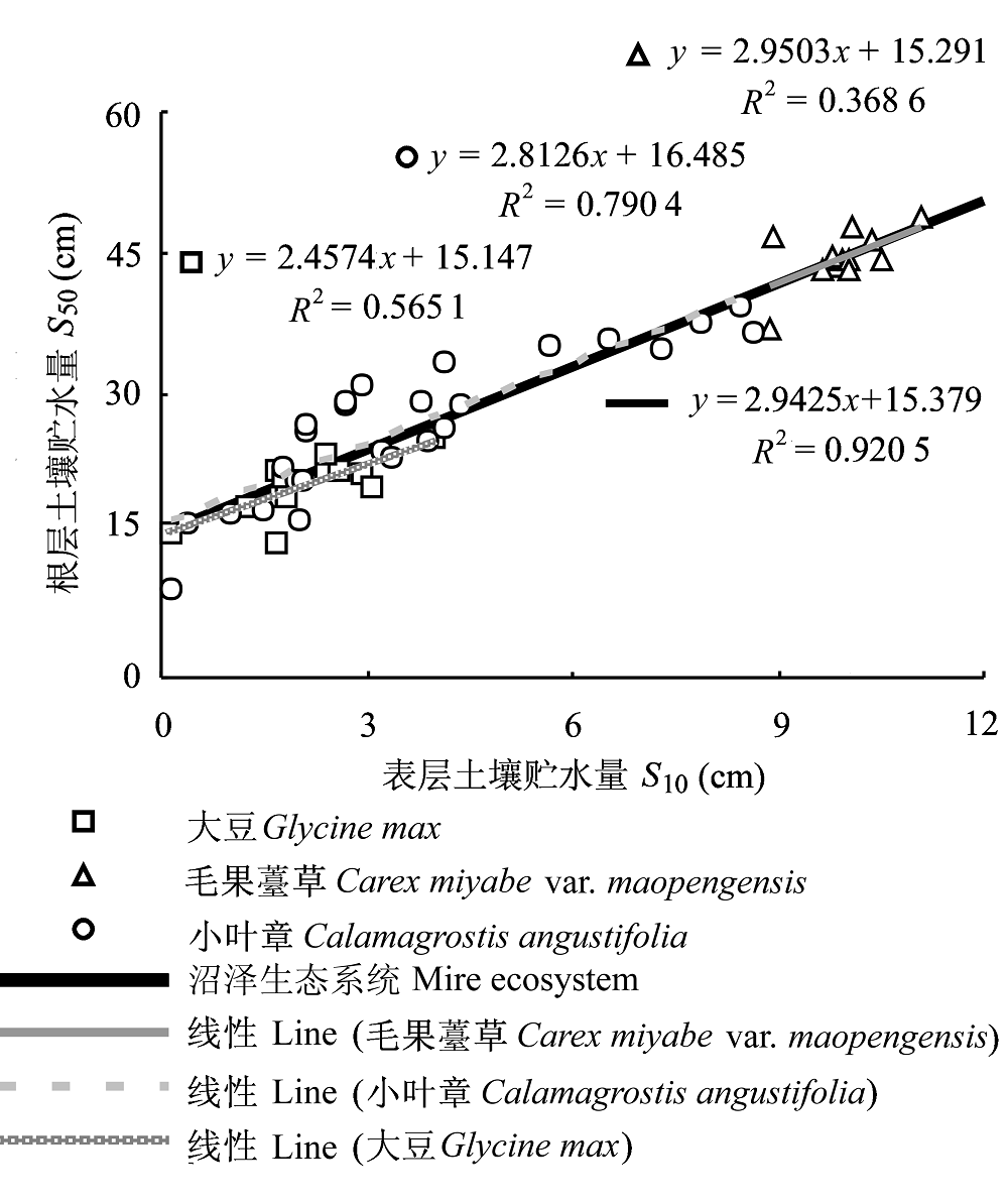
图7 沼泽生态系统和其3个站点植被的根表关系。
Fig. 7 Relationship between top-most layer soil moisture (S10) and root zone layer soil moisture (S50) for mire ecosystem and each of three vegetation sites within the mire system.
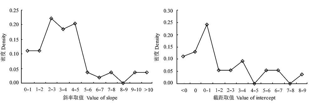
图8 根表关系的斜率和截距取值的频率密度。
Fig. 8 Density plots of slope and intercept of the relationship between top-most layer and root zone layer soil moisture.
| 层次 Layer (cm) | 原始数据 Original data | 标准化数据 Standardized data | |||
|---|---|---|---|---|---|
| 线性关系 Linear relationship | R2 | 线性关系 Linear relationship | R2 | ||
| 0-20 and 0-10 | S20 = 1.9964S10 + 0.2888 | 0.97 | y = 0.9366x + 0.0383 | 0.94 | |
| 0-30 and 0-10 | S30 = 2.9850S10 + 0.7373 | 0.94 | y = 0.8936x + 0.0587 | 0.87 | |
| 0-40 and 0-10 | S40 = 3.9184S10 + 1.3667 | 0.91 | y = 0.8652x + 0.0790 | 0.82 | |
| 0-50 and 0-10 | S50 = 4.8093S10 + 2.1495 | 0.88 | y = 0.8514x + 0.0973 | 0.78 | |
| 0-60 and 0-10 | S60 = 5.6775S10 + 3.0933 | 0.86 | y = 0.8437x + 0.1126 | 0.74 | |
| 0-70 and 0-10 | S70 = 6.6045S10 + 3.9304 | 0.84 | y = 0.8434x + 0.1202 | 0.71 | |
| 0-80 and 0-10 | S80 = 7.4855S10 + 4.9945 | 0.82 | y = 0.8366x + 0.1305 | 0.68 | |
| 0-90 and 0-10 | S90 = 8.3742S10 + 5.9630 | 0.81 | y = 0.8331x + 0.1347 | 0.66 | |
| 0-100 and 0-10 | S100 = 9.2663S10 + 6.8993 | 0.79 | y = 0.8076x + 0.1328 | 0.65 | |
表3 基于原始数据和基于“标乙”法产生的标准化数据的表层和不同厚度土体的根层土壤水分关系
Table 3 Relationship between top-most layer and root zone layer soil moisture with different thicknesses based on original and standardized data by “Biaoyi” method
| 层次 Layer (cm) | 原始数据 Original data | 标准化数据 Standardized data | |||
|---|---|---|---|---|---|
| 线性关系 Linear relationship | R2 | 线性关系 Linear relationship | R2 | ||
| 0-20 and 0-10 | S20 = 1.9964S10 + 0.2888 | 0.97 | y = 0.9366x + 0.0383 | 0.94 | |
| 0-30 and 0-10 | S30 = 2.9850S10 + 0.7373 | 0.94 | y = 0.8936x + 0.0587 | 0.87 | |
| 0-40 and 0-10 | S40 = 3.9184S10 + 1.3667 | 0.91 | y = 0.8652x + 0.0790 | 0.82 | |
| 0-50 and 0-10 | S50 = 4.8093S10 + 2.1495 | 0.88 | y = 0.8514x + 0.0973 | 0.78 | |
| 0-60 and 0-10 | S60 = 5.6775S10 + 3.0933 | 0.86 | y = 0.8437x + 0.1126 | 0.74 | |
| 0-70 and 0-10 | S70 = 6.6045S10 + 3.9304 | 0.84 | y = 0.8434x + 0.1202 | 0.71 | |
| 0-80 and 0-10 | S80 = 7.4855S10 + 4.9945 | 0.82 | y = 0.8366x + 0.1305 | 0.68 | |
| 0-90 and 0-10 | S90 = 8.3742S10 + 5.9630 | 0.81 | y = 0.8331x + 0.1347 | 0.66 | |
| 0-100 and 0-10 | S100 = 9.2663S10 + 6.8993 | 0.79 | y = 0.8076x + 0.1328 | 0.65 | |
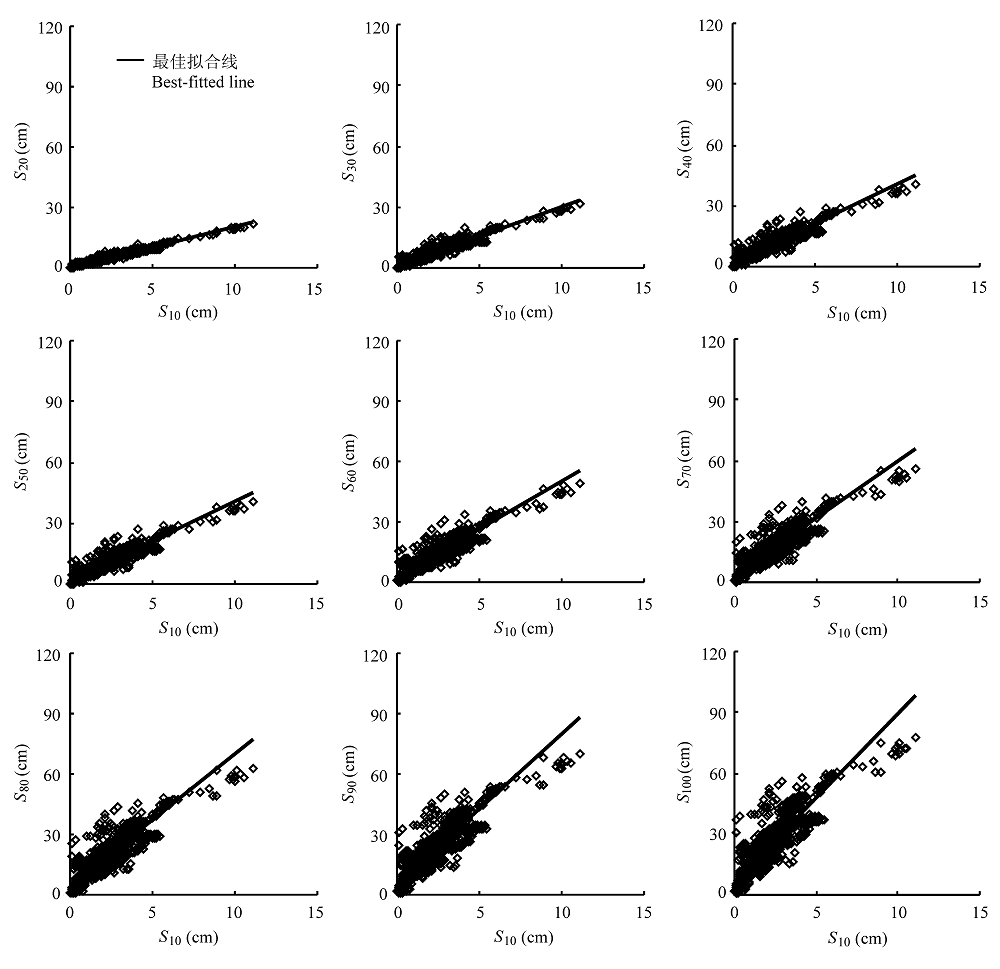
图9 表层土壤贮水量(S10)与不同厚度根层土壤贮水量(S20, S30, …… S100)之间的关系。
Fig. 9 Relationship between top-most layer soil moisture (S10) and different root zone layer soil moisture (S20, S30, … S100).
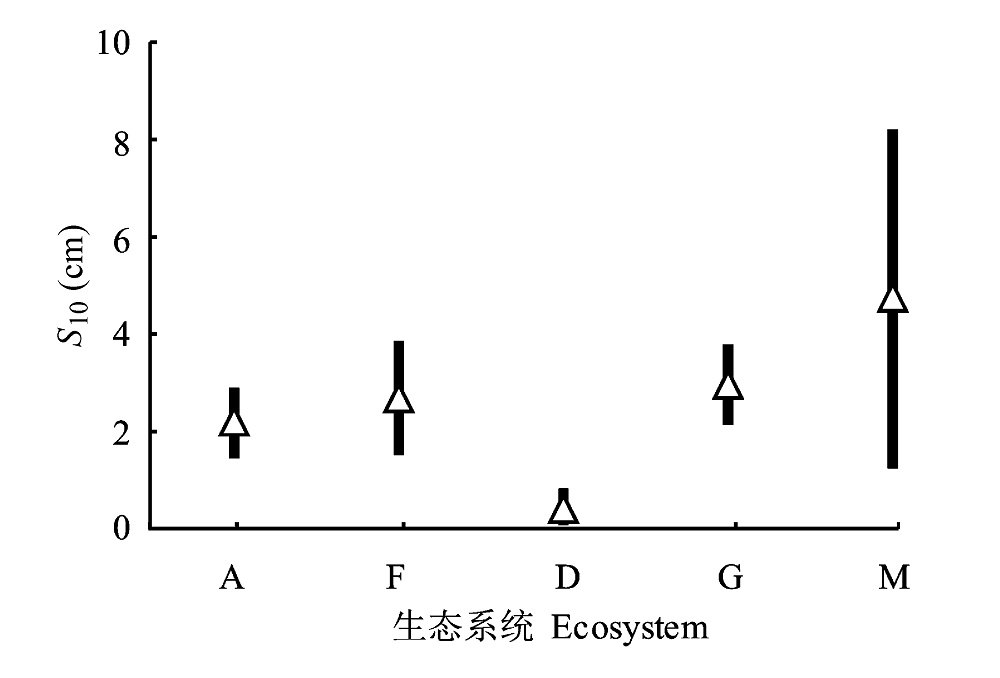
图10 各个生态系统的表层土壤水分(S10)平均值标准均方差。A, 农业生态系统; D, 荒漠生态系统; F, 森林生态系统; G, 草地生态系统; M, 沼泽生态系统。
Fig. 10 Top-most layer soil moisture (S10) for each ecosystem (Average value and standard deviation). A, Agricultural ecosystem; D, Desert ecosystem; F, Forest ecosystem; G, Grass ecosystem; M, mire ecosystem.
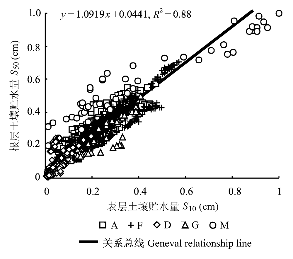
图11 不同生态系统采用“标甲”法标准化的根表关系。A, 农业生态系统; D, 荒漠生态系统; F, 森林生态系统; G, 草地生态系统; M, 沼泽生态系统。
Fig. 11 Relationship between standardized top-most layer soil moisture (S10) and root zone layer soil moisture (S50) for each ecosystem by “Biaojia” method. A, agricultural ecosystem; D, desert ecosystem; F, forest ecosystem; G, grass ecosystem; M, mire ecosystem.
图12 不同生态系统采用“标乙”法标准化的根表关系。A, 农业生态系统; D, 荒漠生态系统; F, 森林生态系统; G, 草地生态系统; M, 沼泽生态系统。
Fig. 12 Relationship between standardized top-most layer soil moisture (S10) and standardized root zone layer soil moisture (S50) for each ecosystem by “Biaoyi” method. A, agricultural ecosystem; D, desert ecosystem; F, forest ecosystem; G, grass ecosystem; M, mire ecosystem.
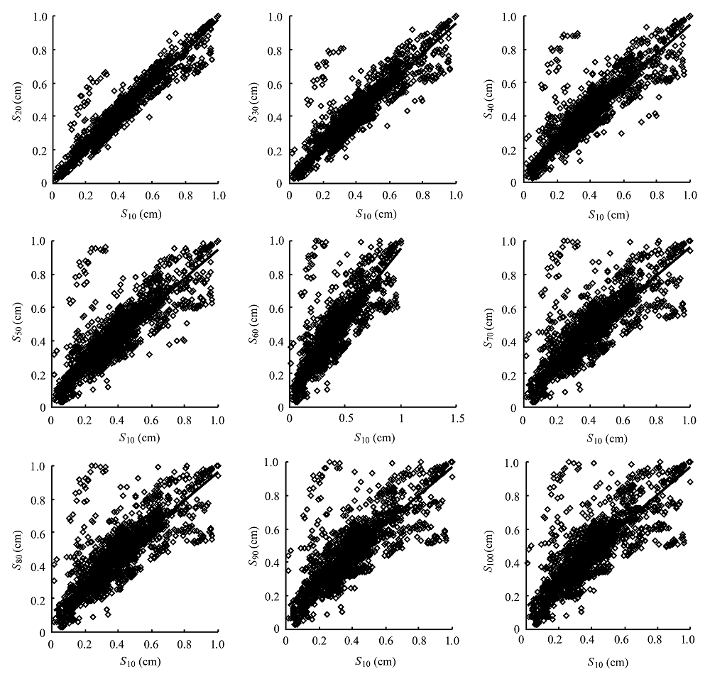
图13 基于“标乙”法得到的标准化表层土壤贮水量(S10)与不同深度深层土壤贮水量(S20、S30、……、S100)之间的关系。
Fig. 13 Relationship between top-layer soil moisture (S10) and root zone layer soil moisture (S20, S30, …, S100) with different thichness based on standardized data by “Biaoyi” method.
| [1] | Biswas BC, Dasgupta SK (1979). Estimate of soil moisture at deeper depth from surface layer data. Mausam, 30(4), 40-45. |
| [2] | Chen SP, Bai YF, Han XG, An JL, Guo FC (2004). Variations in foliar carbon isotope composition and adaptive strategies of Carex korshinskyi along a soil moisture gradient. Acta Phytoecologica Sinica, 28, 515-522. (in Chinese with English abstract) |
| [ 陈世苹, 白永飞, 韩兴国, 安吉林, 郭富存 (2004). 沿土壤水分梯度黄囊苔草碳同位素组成及其适应策略的变化. 植物生态学报, 28, 515-522.] | |
| [3] | Das NN, Mohanty BP (2006). Root zone soil moisture assessment using remote sensing and vadose zone modeling. Vadose Zone Journal, 5, 296-307. |
| [4] | Deng TH, Fu XJ, Shen SH, Zhu ZX (2005). Transforming model of soil moisture between layers of 0-50 cm and 0-100 cm. Agricultural Research in the Arid Areas, 23(4), 64-68, 102. (in Chinese with English abstract) |
| [ 邓天宏, 付祥军, 申双和, 朱自玺 (2005). 0-50 cm与0-100 cm土层土壤湿度的转换关系研究. 干旱地区农业研究, 23(4), 64-68, 102.] | |
| [5] | Dorigo W, van Oevelen P, Wagner W, Drusch M, Mecklenburg S, Robock A, Jackson T (2011). A new international network for in situ soil moisture data. Eos, Transactions American Geophysical Union, 92, 141, doi: 10.1029/2011 EO170001. |
| [6] | Ji F, Ma YJ, Fan ZL (2001). Soil water regime in Populus euphratica forest on the Tarim river alluvial plain. Acta Phytoecologica Sinica, 25, 17-21. (in Chinese with English abstract) |
| [ 季方, 马英杰, 樊自立 (2001). 塔里木河冲积平原胡杨林的土壤水分状况研究. 植物生态学报, 25, 17-21.] | |
| [7] | Jia BQ, Ci LJ, Cai TJ, Gao ZH, Ding F (2002). Preliminary research on changing soil water characters at ecotone between oasis and desert. Acta Phytoecologica Sinica, 26, 203-208. (in Chinese with English abstract) |
| [ 贾宝全, 慈龙骏, 蔡体久, 高志海, 丁峰 (2002). 绿洲-荒漠交错带土壤水分变化特征初步研究. 植物生态学报, 26, 203-208.] | |
| [8] | Jia HK, Liu YH, Xu X, Wang K, Gao Q (2005). Simulation of soil water dynamics in a Caragana intermedia woodland in Huangfuchuan watershed: relationships among slope, aspect, plant density and soil water content. Acta Phytoecologica Sinica, 29, 910-917. (in Chinese with English abstract) |
| [ 贾海坤, 刘颖慧, 徐霞, 王昆, 高琼 (2005). 皇甫川流域柠条林地水分动态模拟——坡度、坡向、植被密度与土壤水分的关系. 植物生态学报, 29, 910-917.] | |
| [9] | Lei ZD, Yang SX, Xie SC (1998). The Dynamics of Soil Water Movement. Tsinghua University Press, Beijing. (in Chinese) |
| [ 雷志栋, 杨诗秀, 谢森传 (1998). 土壤水动力学. 清华大学出版社, 北京.] | |
| [10] | Li MX, Ma ZG, Niu GY (2011). Modeling spatial and temporal variations in soil moisture in China. Chinese Science Bulletin, 56, 1809-1820. |
| [11] | Li ZH, Zhong YK (1996). The research on the dynamic rules of soil moisture in artificial grassland. Acta Scientiarum Naturalium Universitatis Neimongol, 27, 237-241. (in Chinese with English abstract) |
| [ 李政海, 仲延凯 (1996). 人工草地土壤水分动态规律的研究. 内蒙古大学学报(自然科学版), 27, 237-241.] | |
| [12] | Liu CM, Zhao FY (1995). Characteristics of soil moisture in farmlands of arid area. Journal of Northwest Forestry College, 10(Suppl.), 148-152. (in Chinese with English abstract) |
| [ 刘长民, 赵凡衍 (1995). 旱地农田土壤水分含量变化特征研究. 西北林学院学报, 10(增刊), 148-152.] | |
| [13] | Liu JL, Wang YH, Yu PT, Cheng LL, Xiong W, Xu LH, Du AP (2009). Vegetation carrying capacity based on soil water on typical slopes in the Diediegou small watershed of Liupan Mountains, Northwestern China. Chinese Journal of Plant Ecology, 33, 1101-1111. (in Chinese with English abstract) |
| [ 刘建立, 王彦辉, 于澎涛, 程丽莉, 熊伟, 徐丽宏, 杜阿朋 (2009). 六盘山叠叠沟小流域典型坡面土壤水分的植被承载力. 植物生态学报, 33, 1101-1111.] | |
| [14] | Liu JL, Zhang ZH, Xie HX (2006a). Forecasting on deep soil water of cherry orchard of Jiaodong based on surface soil water information. Research of Soil and Water Conservation, 13, 96-99. (in Chinese with English abstract) |
| [ 刘继龙, 张振华, 谢恒星 (2006a). 基于表层水分信息的胶东樱桃园深层土壤水分估算研究. 水土保持研究, 13, 96-99.] | |
| [15] | Liu JL, Zhang ZH, Xie HX (2006b). On conversion relation between surface and deep soil water of apple orchard. Research of Agricultural Modernization, 27, 304-306. (in Chinese with English abstract) |
| [ 刘继龙, 张振华, 谢恒星 (2006b). 苹果园表层与深层土壤水分的转换关系研究. 农业现代化研究, 27, 304-306.] | |
| [16] | Liu JL, Zhang ZH, Xie HX, Cai HJ (2007). Water holding capacity in soil of root layer of pear orchard in Jiaodong region. Chinese Journal of Soil Science, 38, 640-644. (in Chinese with English abstract) |
| [ 刘继龙, 张振华, 谢恒星, 蔡焕杰 (2007). 胶东梨园根系层土壤贮水量估算研究. 土壤通报, 38, 640-644.] | |
| [17] |
Liu SX, Mo XG, Li HB, Peng GB, Robock A (2001). The spatial variation of soil moisture in China: geostatistical characteristics. Journal of the Meteorological Society of Japan, 79(2B), 555-574.
DOI URL |
| [18] | Liu SX, Leslie LM, Speer M, Bunker R, Morison R (2003). Approaching realistic soil moisture status in the Goulburn River catchment of southeastern Australia before and after a bushfire with an improved meso-scale numerical weather prediction model. In: Tachikawa Y, Viean BE, Georgakkos KP, Nakakita E eds. Proceedings for the XXIII General Assembly of the International Union of Geodesy and Geophysics., Sapporo, Japan, IAHS, 282, 215-320. |
| [19] | Liu SX, Mao LX, Mo XG, Zhao WM, Lin ZH (2008). Analysis of spatial variability of soil moisture and its driving force factors in the Shaanxi-Henan region along the Yellow River. Climatic and Environmental Research, 13, 645-657. (in Chinese with English abstract) |
| [ 刘苏峡, 毛留喜, 莫兴国, 赵卫民, 林忠辉 (2008). 黄河沿岸陕豫区土壤水分的空间变化特征及其驱动力因子分析. 气候与环境研究, 13, 645-657.] | |
| [20] | Liu SX, Mo XG, Zhao WM, Naeimi V, Dai D, Shu C, Mao L (2009). Temporal variation of soil moisture over the Wuding River Basin assessed with an eco-hydrological model,in-situ observations and remote sensing. Hydrology and Earth System Sciences, 13, 1375-1398. |
| [21] | Liu SX, Mo XG, Li J, Liu WD (1999). The effects of soil moisture and soil-atmosphere interface on water-heat transfer in winter wheat field. Geographical Research, 18, 24-30. (in Chinese with English abstract) |
| [ 刘苏峡, 莫兴国, 李俊, 刘伟东(1999). 土壤水分及土壤-大气界面对麦田水热传输的作用. 地理研究, 18, 24-30.] | |
| [22] | Mahmood R, Hubbard KG (2007). Relationship between soil moisture of near surface and multiple depths of the root zone under heterogeneous land uses and varying hydroclimatic conditions. Hydrological Processes, 21, 3449-3462. |
| [23] | Martinez C, Hancock GR, Kalma JD, Wells T (2008). Spatio-temporal distribution of near-surface and root zone soil moisture at the catchment scale. Hydrological Processes, 22, 2699-2714. |
| [24] | Mo XG, Qiu JX, Liu SX, Naeimi V (2011). Estimating root-layer soil moisture for the North China Plain from multiple data sources In: Hafeez M, van de Giesen N, Bardsley E, Seyler F, Pail R, Taniguchi M eds. Grace, Remote Sensing and Ground-Based Methods in Multi- Scale Hydrology. IAHS Publication, Melbourne. 343, 118-124. |
| [25] | Ragab R (1995). Towards a continuous operational system to estimate the root-zone soil moisture from intermittent remotely sensed surface moisture. Journal of Hydrology, 173, 1-25. |
| [26] | Ren L, Li CY, Li YZ (1998). Applications of new model to simulating the moisture variation of layered clayey soils. Journal of China Agricultural University, 3, 57-62. (in Chinese with English abstract) |
| [ 任理, 李春友, 李韵珠 (1998). 层状粘性土壤水分动态新模型的应用. 中国农业大学学报, 3, 57-62.] | |
| [27] | Robock A, Vinnikov KY, Srinivasan G, Entin JK, Hollinger SE, Speranskaya NA, Liu SX, Namkhai A (2000). The global soil moisture data bank. Bulletin of the American Meteorological Society, 81, 1281-1299. |
| [28] | Sanderson K (2009). Satellite launches to track the world’s water. Nature, doi: 10.1038/news.2009.1054. |
| [29] | Science News (2008). How Dry We Are: European Space Agency To Test Earth’s Soil Moisture Via Satellite. 2008, April 29. |
| [30] | Sun L, Xiong W, Guan W, Wang YH, Xu LH (2011). Use of storage water in Larix principis-ruprechtii and its response to soil water content and potential evapotranspiration: a modeling analysis. Chinese Journal of Plant Ecology, 35, 411-421. (in Chinese with English abstract) |
| [ 孙林, 熊伟, 管伟, 王彦辉, 徐丽宏 (2011). 华北落叶松树体储水利用及其对土壤水分和潜在蒸散的响应: 基于模型模拟的分析. 植物生态学报, 35, 411-421.] | |
| [31] | Wang HL, Zhang XC, Song SY (2011). Effects of mulching methods on soil water dynamics and corn yield of rain-fed cropland in the semiarid area of China. Chinese Journal of Plant Ecology, 35, 825-833. (in Chinese with English abstract) |
| [ 王红丽, 张绪成, 宋尚有 (2011). 半干旱区旱地不同覆盖种植方式玉米田的土壤水分和产量效应. 植物生态学报, 35, 825-833.] | |
| [32] | Wei YF, Guo K, Chen JQ (2008). Effect of precipitation pattern on recruitment of soil water in Kubuqi Desert, Northwestern China. Journal of Plant Ecology (Chinese Version), 32, 1346-1355. (in Chinese with English abstract) |
| [ 魏雅芬, 郭柯, 陈吉泉 (2008). 降雨格局对库布齐沙漠土壤水分的补充效应. 植物生态学报, 32, 1346-1355.] | |
| [33] | Yang JJ, Cai HJ, Wang SH, Xie HX (2010). Relationship between soil moisture in surface layer and in deeper depth in Yangling. Agricultural Research in the Arid Areas, 28(3), 53-57. (in Chinese with English abstract) |
| [ 杨静敬, 蔡焕杰, 王松鹤, 谢恒星 (2010). 杨凌区浅层土壤水分与深层土壤水分的关系研究. 干旱地区农业研究, 28(3), 53-57.] | |
| [34] | Zhan DJ, Ye SZ (2007). Engineering Hydrology. China Water Power Press, Beijing. (in Chinese) |
| [ 詹道江, 叶守泽 (2007). 工程水文学. 中国水利水电出版社, 北京.] | |
| [35] | Zhang JY, Wu LY (2011). Land-atmosphere coupling amplifies hot extremes over China. Chinese Science Bulletin, 56, 1905-1909. |
| [1] | 刘志祥, 黎凤兰, 黄晓磊. 昆虫虫瘿生态系统的复杂性及成瘿机制研究进展[J]. , 2027, 51(动植物互作): 0-. |
| [2] | 吴光进, 郭垚鑫, 任成杰, 王俊, 岳明, 赵发珠. 秦岭北麓不同植被类型土壤有机碳含量分布及其影响因素[J]. 植物生态学报, 2026, 50(预发表): 1-. |
| [3] | 谭秋颜, 张清, 高程, 褚海燕, 杨腾. 外生菌根真菌: 高寒生态系统碳氮循环的关键驱动者[J]. 植物生态学报, 2026, 50(3): 584-599. |
| [4] | 马建辉, 童鑫, 张思榕, 毛子昆, 秦俊, 马克平. 菌根真菌生理生态功能研究进展及展望[J]. 植物生态学报, 2026, 50(3): 498-514. |
| [5] | 方迪, 马宁, 李胜功, 郑甲佳, 褚云馨, 杨锦昌, 杨赞明, 张龙宁, 孟盛旺, 高德才, 戴晓琴, 付晓莉, 王辉民, 寇亮. 菌根共生类型对森林养分内循环的调控作用[J]. 植物生态学报, 2026, 50(3): 552-565. |
| [6] | 张静, 陈洁, 李艳朋, 盘李军, 许涵, 李意德, 何海生. 南亚热带针阔混交人工林植物生物量比较及其影响因子分析[J]. 植物生态学报, 2026, 50(2): 400-416. |
| [7] | 张健, 孙慕梵, 宋坤, 赖丽茗, 宋永昌. 基于生态外貌-植物区系分类系统的中国常绿阔叶林分类修订[J]. 植物生态学报, 2026, 50(1): 107-122. |
| [8] | 徐恩相, 周蕾, 章晓炜, 张国萍, 仲杜伟, 黄智, 刘派, 迟永刚. 基于不同生育阶段冠层光谱和碳通量的水稻产量估算[J]. 植物生态学报, 2026, 50(1): 82-93. |
| [9] | 冉佳鑫, 何舒婷, 罗素萍, 王云, 毛超. 森林土壤氮转化速率特征及其影响因素[J]. 植物生态学报, 2026, 50(1): 45-54. |
| [10] | 朱喜, 何志斌, 杜明武, 赵丽雯, 吴丹丹. 2004-2010年河西走廊中段绿洲农田生态系统长期监测样地作物性状和产量数据集[J]. 植物生态学报, 2025, 49(8): 1312-1320. |
| [11] | 王鹏, 李向义, 高艳菊, 热甫开提·沙比提, 曾凡江. 2005-2010年塔克拉玛干沙漠南缘绿洲农田长期监测样地棉花收获期性状和产量数据集[J]. 植物生态学报, 2025, 49(8): 1329-1338. |
| [12] | 周志琼, 丁建林, 李晓明, 何其华. 2005-2010年西南山地人工林长期监测样地植物物种组成与群落特征数据集[J]. 植物生态学报, 2025, 49(8): 1255-1262. |
| [13] | 王立龙, 冯静, 苏娜, 刘新平, 潘成臣, 李玉强. 2005-2015年科尔沁沙地典型农田生态系统长期监测样地玉米收获期性状和产量数据集[J]. 植物生态学报, 2025, 49(8): 1293-1300. |
| [14] | 张琳, 袁伟影, 宋创业, 吴冬秀. 1998-2010年中国典型生态系统长期监测样地环境要素、物种丰富度和生物量动态数据集[J]. 植物生态学报, 2025, 49(8): 1182-1190. |
| [15] | 张琳, 陈华阳, 黄振英. 2004-2010年鄂尔多斯沙地草地长期监测样地植物物种组成和群落特征数据集[J]. 植物生态学报, 2025, 49(8): 1263-1270. |
| 阅读次数 | ||||||
|
全文 |
|
|||||
|
摘要 |
|
|||||
Copyright © 2026 版权所有 《植物生态学报》编辑部
地址: 北京香山南辛村20号, 邮编: 100093
Tel.: 010-62836134, 62836138; Fax: 010-82599431; E-mail: apes@ibcas.ac.cn, cjpe@ibcas.ac.cn
备案号: 京ICP备16067583号-19
![]()