
Chin J Plant Ecol ›› 2016, Vol. 40 ›› Issue (2): 102-115.DOI: 10.17521/cjpe.2014.0366 cstr: 32100.14.cjpe.2014.0366
Special Issue: 生态遥感及应用
• Research Articles • Previous Articles Next Articles
Rui-Ying ZHANG1,2, Yong PANG2, Zeng-Yuan LI2,*( ), Yu-Hai BAO1
Online:2016-02-10
Published:2016-03-08
Contact:
Zeng-Yuan LI
Rui-Ying ZHANG, Yong PANG, Zeng-Yuan LI, Yu-Hai BAO. Canopy closure estimation in a temperate forest using airborne LiDAR and LANDSAT ETM+ data[J]. Chin J Plant Ecol, 2016, 40(2): 102-115.
Add to citation manager EndNote|Ris|BibTeX
URL: https://www.plant-ecology.com/EN/10.17521/cjpe.2014.0366
| 波段名称 Band name | 波段号 Band number | 波长范围 Wavelength range (µm) | 对应的原始波段号 Corresponding original band number | 增益系数 Gain |
|---|---|---|---|---|
| 红 Red | 1 | 0.63-0.69 | 3 | 508 |
| 近红外 Near infrared | 2 | 0.75-0.90 | 4 | 254 |
| 短波红外1 Short wave infrared 1 | 3 | 1.55-1.75 | 5 | 363 |
| 短波红外2 Short wave infrared 2 | 4 | 2.09-2.35 | 7 | 423 |
Table 1 The spectrum information and radiometric calibration parameters of LANDSAT ETM+ data
| 波段名称 Band name | 波段号 Band number | 波长范围 Wavelength range (µm) | 对应的原始波段号 Corresponding original band number | 增益系数 Gain |
|---|---|---|---|---|
| 红 Red | 1 | 0.63-0.69 | 3 | 508 |
| 近红外 Near infrared | 2 | 0.75-0.90 | 4 | 254 |
| 短波红外1 Short wave infrared 1 | 3 | 1.55-1.75 | 5 | 363 |
| 短波红外2 Short wave infrared 2 | 4 | 2.09-2.35 | 7 | 423 |
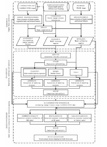
Fig. 1 The flowchart of forest canopy closure inversion based on LANDSAT ETM+ image.
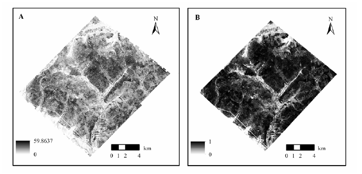
Fig. 2 The calculation result of canopy closure. A, Canopy height model (m). B, Canopy closure result from calculation.
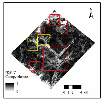
Fig. 3 The image of sample selecting range (the red area is the training sample and the yellow area is the validation sample).
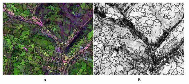
Fig. 4 The segmentation results of LANDSAT ETM+ image and canopy closure. A, The segmentation result of LANDSAT ETM+ image. B, The segmentation result of canopy closure.
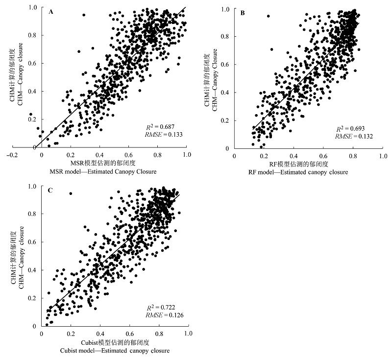
Fig. 5 The scatterplot of model accuracy validation. A, multi-variable stepwise regret ssion (MSR) model-the scatterplot of model accuracy validation. B, Random forest (RF) model-the scatterplot of model accuracy validation. C, Cubist model-the scatterplot of model accuracy validation. CHM, canopy height model; RMSE, root mean square error.
| [1] | Birth GS, McVey GR (1968). Measuring the color of growing turf with a reflectance spectrophotometer.Agronomy Journal, 60, 640-643. |
| [2] | Breiman L (2001). Random forests.Machine Learning, 45, 5-32. |
| [3] | Chen C, Zhu YJ, Ju WM (2011). Retrieval of subtropical forest canopy closure from remote sensing by using akaike information criterion and artificial neural network model.Acta Agriculturae Jiangxi, 23(5), 149-153.(in Chinese with English abstract)[陈崇, 朱延钧, 居为民 (2011). 基于赤池信息准则和人工神经网络的亚热带森林郁闭度遥感估算. 江西农业学报, 23(5), 149-153.] |
| [4] | Colombo R, Bellingeri D, Fasolini D, Marino CM (2003). Retrieval of leaf area index in different vegetation types using high resolution satellite data.Remote Sensing of Environment, 86, 120-131. |
| [5] | Coulston JW, Moisen GG, Wilson BT, Finco MV, Cohen WB, Brewer CK (2012). Modeling percent tree canopy cover: A pilot study.Photogrammetric Engineering & Remote Sensing, 78, 715-727. |
| [6] | Deering DW, Rouse JW, Haas RH, Schell JA (1975). Measuring 'Forage production' of grazing units from LANDSAT MSS data. International Symposium on Remote Sensing of Environment, 10th, Ann Arbor, Mich, 1169-1178. |
| [7] | Du WF, Wang FZ, Li Q (1999). Some suggestions for increasing accuracy of canopy closure investigation. Forest resources management, (3), 62-64(in Chinese).[杜文峰, 王凤臻, 李庆 (1999). 提高郁闭度调查精度的几点建议. 林业资源管理, (3), 62-64.] |
| [8] | Du XM, Cai TJ, Ju CY (2008). Estimation of forest canopy closure by using parital least square regression.Chinese Journal of Applied Ecology, 19, 273-277.(in Chinese with English abstract)[杜晓明, 蔡体久, 琚存勇 (2008). 采用偏最小二乘回归方法估测森林郁闭度. 应用生态学报, 19, 273-277.] |
| [9] | Fang KN, Wu JB, Zhu JP, Xie BC (2011). A review of technologies on random forest.Statistics & Information Tribune, 25(3), 32-37.(in Chinese with English abstract)[方匡南, 吴见彬, 朱建平, 谢邦昌 (2011). 随机森林方法研究综述. 统计与信息论坛,25(3), 32-37.] |
| [10] | Fu T, Pang Y, Huang QF, Liu QW, Xu GC (2011). Prediction of subtropical forest parameters using airborne laser scanner.Journal of Remote Sensing, 15, 1092-1104.(in English and Chinese)[付甜, 庞勇, 黄庆丰, 刘清旺, 徐光彩 (2011). 亚热带森林参数的机载激光雷达估测. 遥感学报, 15, 1092-1104.] |
| [11] | Gao YF, Li ZG, Yang ST, Liu XC, Cao Y (2012). Study on canopy density retrieval method from SPOT5.Research of Soil and Water Conservation, 19, 268-270.(in Chinese with English abstract)[高云飞, 李智广, 杨胜天, 刘宪春, 曹勇 (2012). 基于SPOT5影像的郁闭度反演方法. 水土保持研究, 19, 268-270.] |
| [12] | Gleason CJ, Im J (2012). Forest biomass estimation from airborne LiDAR data using machine learning approaches.Remote Sensing of Environment, 125, 80-91. |
| [13] | Hansen MC, Potapov PV, Moore R, Hancher M, Turubanova SA, Tyukavina A, Thau D, Stehman SV, Goetz SJ, Loveland TR, Kommareddy A, Egorov A, Chini L, Justice CO, Townshend JRG (2013). High-resolution global maps of 21st-century forest cover change.Science, 342, 850-853. |
| [14] | Hudak AT, Evans JS, Smith AMS (2009). LiDAR utility for natural resource managers.Remote Sensing, 1, 934-951. |
| [15] | Huete AR (1988). A soil-adjusted vegetation index (SAVI).Remote Sensing of Environment, 25, 295-309. |
| [16] | Korhonen L, Korpela I, Heiskanen J, Maltamo M (2011). Airborne discrete-return LiDAR data in the estimation of vertical canopy cover, angular canopy closure and leaf area index. Remote Sensing of Environment, 115, 1065-1080. |
| [17] | Kuhn M, Witson S, Keefer C, Coulter N (. |
| [18] | Lei CL, Ju CY, Cai TJ, Jing X, Wei XH, Di XY (2012). Estimating canopy closure density and above-ground tree biomass using partial least square methods in Chinese boreal forests.Journal of Forestry Research, 23, 191-196. |
| [19] | Li YN, Zhang BL, Qin SY, Li SY, Huang XR (2008). Review of research and application of forest canopy closure and its measuring methods.World Forestry Research, 21(1), 41-46.(in Chinese with English abstract)[李永宁, 张宾兰, 秦淑英, 李帅英, 黄选瑞 (2008). 郁闭度及其测定方法研究与应用. 世界林业研究,21, 41-46.] |
| [20] | Liu DW, Sun GQ, Pang Y, Cai YL (2006). Estimation of forest closure using LANDSAT TM data.Remote Sensing Information, (1), 41-42.(in Chinese with English abstract)[刘大伟, 孙国清, 庞勇, 蔡玉林 (2006). 利用LANDSAT TM数据对森林郁闭度进行遥感分级估测. 遥感信息, (1), 41-42.] |
| [21] | Moeser D, Roubinek J, Schleppi P, Morsdorf F, Jonas T (2014). Canopy closure, LAI and radiation transfer from Airborne LiDAR synthetic images.Agricultural and Forest Meteorology, 197(19), 158-168. |
| [22] | Nelson R, Krabill W, MacLean G (1984). Determining forest canopy characteristics using airborne laser data.Remote Sensing of Environment, 15, 201-212. |
| [23] | Nelson R, Krabill W, Tonelli J (1988). Estimating forest biomass and volume using airborne laser data.Remote Sensing of Environment, 24, 247-267. |
| [24] | Pang Y, Huang KB, Li ZY, Qin XL, Chen EX (2011). Forest aboveground biomass analysis using remote sensing in the Greater Mekong Subregion. Recourses Science, 33, 1863-1869.(in Chinese with English abstract)[庞勇, 黄克标, 李增元, 覃先林, 陈尔学 (2011). 基于遥感的湄公河次区域森林地上生物量分析 . 资源科学,33, 1863-1869.] |
| [25] | Pang Y, Li ZY (2012). Inversion of biomass components of the temperate forest using airborne LiDAR technology in Xiaoxing'an Mountains, Northeastern of China.Chinese Journal of Plant Ecology, 36, 1095-1105.(in Chinese with English abstract)[庞勇, 李增元 (2012). 基于机载激光雷达的小兴安岭温带森林组分生物量反演 . 植物生态学报,36, 1095-1105.] |
| [26] | Pang Y, Li ZY, Chen EX, Sun GQ (2005). LiDAR remote sensing technology and its application in forestry.Scientia Silvae Sinicae, 41(3), 129-136.(in Chinese with English abstract)[庞勇, 李增元, 陈尔学, 孙国清 (2005). 激光雷达技术及其在林业上的应用. 林业科学,41(3), 129-136.] |
| [27] | Powell SL, Cohen WB, Healey SP, Kennedy RE, Moisen GG, Pierce KB, Ohmann JL (2010). Quantification of live aboveground forest biomass dynamics with LANDSAT time-series and field inventory data: A comparison of empirical modeling approaches.Remote Sensing of Environment, 114, 1053-1068. |
| [28] | Qi J, Chehbouni A, Huete AR, Kerr YH, Sorooshian S (1994). A modified soil adjusted vegetation index.Remote Sensing of Environment, 48, 119-126. |
| [29] | Richardson AJ, Wiegand CL (1977). Distinguishing vegetation from soil background information.Phote Engin & Remote Sense, 43, 1541-1552. |
| [30] | Rosette JAB, North PRJ, Suárez JC (2008). Vegetation height estimates for a mixed temperate forest using satellite laser altimetry.International Journal of Remote Sensing, 29, 1475-1493. |
| [31] | Roujean JL, Breon FM (1995). Estimating PAR absorbed by vegetation from bidirectional reflectance measurements.Remote Sensing of Environment, 51, 375-384. |
| [32] | Rouse JW, Haas RH, Schell JA, Deering DW (1974). Monitoring vegetation systems in Great Plains with ERTS.NASA Special Publication, 351, 309. |
| [33] | Sexton JO, Song XP, Feng M, Noojipady P, Anand A, Huang CQ, Kim D, Collins KM, Channan S, Dimiceli C, Townshend JR (2014). Global, 30-m resolution continuous fields of tree cover: LANDSAT-based rescaling of MODIS vegetation continuous fields with LiDAR-based estimates of error.International Journal of Digital Earth, 6, 427-448. |
| [34] | Soininen A (. |
| [35] | Tan BX, Li ZY, Chen EX, Pang Y, Lei YC (2006). Estimating forest crown closure using hyperion hyperspectral data.Journal of Beijing Forestry University, 28(3), 95-101.(in Chinese with English abstract)[谭炳香, 李增元, 陈尔学, 庞勇, 雷渊才 (2006). Hyperion高光谱数据森林郁闭度定量估测研究 . 北京林业大学学报,28(3), 95-101.] |
| [36] | Wang T (2010). Application on M5 algorithm in sensory evaluation.Microcomputer Information, 26(11-3), 229-231.(in Chinese with English abstract)[王涛 (2010). M5算法在感觉评估中的应用. 微计算机信息, 26(11-3), 229-231.] |
| [37] | Wang YF, Pang Y, Shu QT (2013). Counter-estimation on aboveground biomass of Hevea brasiliensis plantation by remote sensing with random forest algorithm--A case study of Jinghong.Journal of Southwest Forestry University, 33(6), 38-45.(in Chinese with English abstract)[王云飞, 庞勇, 舒清态 (2013). 基于随机森林算法的橡胶林地上生物量遥感反演研究----以景洪市为例 . 西南林业大学学报,33(6), 38-45.] |
| [38] | Wu Y, Zhang DR, Zhang HK, Wu HG (2012). Remote sensing estimation of canopy density combined with texture features.Scientia Silvae Sinicae, 48(2), 48-53.(in Chinese with English abstract)[吴飏, 张登荣, 张汉奎, 武红敢 (2012). 结合图像纹理特征的森林郁闭度遥感估测. 林业科学, 48(2), 48-53.] |
| [39] | Xu D, Peng DL (2013). Estimation of forest canopy closure based on dimidiate pixel model.Journal of Northeast Forestry University, 41(2), 119-122.(in Chinese with English abstract) [徐定, 彭道黎 (2013). 基于像元二分模型的森林郁闭度估测方法. 东北林业大学学报,41(2), 119-122.] |
| [40] | Zeng T, Ju CY, Cai TJ, Liu WB, Yao YF (2010). Selection of parameters for estimation canopy closure density using variable importance of projection criterion.Journal of Beijing Forestry University, 32(6), 37-41.(in Chinese with English abstract)[曾涛, 琚存勇, 蔡体久, 刘文彬, 姚月锋 (2010). 利用变量投影重要性准则筛选郁闭度估测参数 . 北京林业大学学报,32(6), 37-41.] |
| [41] | Zhang J, Li XS, Wu BF (2014). Forest cover estimation based on classification and regression trees of Miyun Reservoir upstream area. Remote Sensing Technology and Application, 29, 394-400.(in Chinese with English abstract)[张瑾, 李晓松, 吴炳方 (2014). 基于分类回归树的密云水库上游森林覆盖度遥感估算. 遥感技术与应用,29, 394-400.] |
| [42] | Zhao YS (2003).Analysis Principle and Method of Remote Sensing Applications. 2nd edn. Science Press,Beijing. 368-380.(in Chinese)[赵英时 (2003). 遥感应用分析原理与方法(第二版). 科学出版社, 北京. 368-380.] |
| [43] | Zheng DM, Zeng WS, Zhi CG, Shi PC (2013). Remote sensing estimation of forest canopy closure in forests of Three Gorges Reservoir Region.Journal of Central South Forestry University, 33(9), 1-4.(in Chinese with English abstract)[郑冬梅, 曾伟生, 智长贵, 施鹏程 (2013). 三峡库区森林郁闭度的遥感定量估测. 中南林业科技大学学报, 33(9), 1-4.] |
| [44] | Zou J, Zhuge XD (2011). Forest canopy closure and the measured methodology.Heilongjiang Science and Technology Information, 35, 290.(in Chinese) [邹杰, 诸葛祥东 (2011). 森林郁闭度及其测定方法 . 黑龙江科技信息,35, 290.] |
| [1] | XU Meng-Zhen, LU Zheng-Kuan, TAN Xing-Ru, WANG Yan-Bing, SU Tian-Cheng, DOU Shan-De, PAN Qing-Min, CHEN Shi-Ping. Identification of key factors and construction of a rapid diagnostic indicator system for evaluation of grassland degradation in Hulun Buir meadow grasslands [J]. Chin J Plant Ecol, 2025, 49(1): 42-58. |
| [2] | LAN Guang-Fei, ZHANG Qiang, CHEN Xiang-Biao, CHEN Shi-Dong, XIONG De-Cheng, LIU Xiao-Fei, YANG Zhi-Jie, YANG Yu-Sheng. Seasonal dynamics of litterfall of a Castanopsis kawakamii evergreen broadleaf forest in mid-subtropical China and their influencing factors [J]. Chin J Plant Ecol, 2024, 48(12): 1589-1601. |
| [3] | WU Han, BAI Jie, LI Jun-Li, Guli JIAPAER, BAO An-Ming. Study of spatio-temporal variation in fractional vegetation cover and its influencing factors in Xinjiang, China [J]. Chin J Plant Ecol, 2024, 48(1): 41-55. |
| [4] | CHEN Xue-Ping, ZHAO Xue-Yong, ZHANG Jing, WANG Rui-Xiong, LU Jian-Nan. Variation of NDVI spatio-temporal characteristics and its driving factors based on geodetector model in Horqin Sandy Land, China [J]. Chin J Plant Ecol, 2023, 47(8): 1082-1093. |
| [5] | MIAO Li-Juan, ZHANG Yu-Yang, CHUAI Xiao-Wei, BAO Gang, HE Yu, ZHU Jing-Wen. Effects of climatic factors and their time-lag on grassland NDVI in Asian drylands [J]. Chin J Plant Ecol, 2023, 47(10): 1375-1385. |
| [6] | ZHU Yu-Ying, ZHANG Hua-Min, DING Ming-Jun, YU Zi-Ping. Changes of vegetation greenness and its response to drought-wet variation on the Qingzang Plateau [J]. Chin J Plant Ecol, 2023, 47(1): 51-64. |
| [7] | WEN Ke, YAO Huan-Mei, GONG Zhu-Qing, NA Ze-Lin, WEI Yi-Ming, HUANG Yi, CHEN Hua-Quan, LIAO Peng-Ren, TANG Li-Ping. Influence of inundation frequency change on enhanced vegetation index of wetland vegetation in Poyang Lake, China [J]. Chin J Plant Ecol, 2022, 46(2): 148-161. |
| [8] | YUAN Yuan, MU Yan-Mei, DENG Yu-Jie, LI Xin-Hao, JIANG Xiao-Yan, GAO Sheng-Jie, ZHA Tian- Shan, JIA Xin. Effects of land cover and phenology changes on the gross primary productivity in an Artemisia ordosica shrubland [J]. Chin J Plant Ecol, 2022, 46(2): 162-175. |
| [9] | ZHAO Yan-Ping, WANG Zhong-Wu, WENDU Rigen, ZHAO Yu-Jin, BAI Yong-Fei. Remotely sensed monitoring method of grassland plant functional diversity and its relationship with productivity based on Sentinel-2 satellite data [J]. Chin J Plant Ecol, 2022, 46(10): 1234-1250. |
| [10] | LIU Chao, LI Ping, WU Yun-Tao, PAN Sheng-Nan, JIA Zhou, LIU Ling-Li. Estimation of grassland aboveground biomass using digital photograph and canopy structure measurements [J]. Chin J Plant Ecol, 2022, 46(10): 1280-1288. |
| [11] | ZHOU Kai-Ling, ZHAO Yu-Jin, BAI Yong-Fei. Study on forest plant diversity monitoring based on Sentinel-2A satellite data in northeast China [J]. Chin J Plant Ecol, 2022, 46(10): 1251-1267. |
| [12] | Ning LIU, Shou-Zhang PENG, Yun-Ming CHEN. Temporal effects of climate factors on vegetation growth on the Qingzang Plateau, China [J]. Chin J Plant Ecol, 2022, 46(1): 18-26. |
| [13] | NI Ming, ZHANG Xi-Yue, JIANG Chao, WANG He-Song. Responses of vegetation to extreme climate events in southwestern China [J]. Chin J Plant Ecol, 2021, 45(6): 626-640. |
| [14] | JI Yu-He, ZHOU Guang-Sheng, WANG Shu-Dong, WANG Li-Xia, ZHOU Meng-Zi. Evolution characteristics and its driving forces analysis of vegetation ecological quality in Qinling Mountains region from 2000 to 2019 [J]. Chin J Plant Ecol, 2021, 45(6): 617-625. |
| [15] | XUE Peng-Fei, LI Wen-Long, ZHU Gao-Feng, ZHOU Hua-Kun, LIU Chen-Li, YAN He-Piao. Changes in the pattern of an alpine wetland landscape in Maqu County in the first meander of the Yellow River [J]. Chin J Plant Ecol, 2021, 45(5): 467-475. |
| Viewed | ||||||
|
Full text |
|
|||||
|
Abstract |
|
|||||
Copyright © 2026 Chinese Journal of Plant Ecology
Tel: 010-62836134, 62836138, E-mail: apes@ibcas.ac.cn, cjpe@ibcas.ac.cn
![]()