
植物生态学报 ›› 2005, Vol. 29 ›› Issue (2): 208-217.DOI: 10.17521/cjpe.2005.0027
周传艳1,2, 周国逸1,*( ), 闫俊华1, 王旭1
收稿日期:2004-02-18
接受日期:2004-12-02
出版日期:2005-02-18
发布日期:2005-03-10
通讯作者:
周国逸
作者简介:*E-mail:gyzhou@scib.ac.Cn基金资助:
ZHOU Chuan-Yan1,2, ZHOU Guo-Yi1,*(), YAN Jun-Hua1, WANG Xu1
Received:2004-02-18
Accepted:2004-12-02
Online:2005-02-18
Published:2005-03-10
Contact:
ZHOU Guo-Yi
摘要:
分析鼎湖山3种植被类型生态系统水文的长期连续观测资料,采用时空互代的方法,得到如下一些结果:1)鼎湖山自然保护区东沟集水区产水量达到降水量的66.5%,日径流量高峰的出现相对降水的发生滞后1d左右。2)地下水位平均稳定在2.22m,最低为2.84m,最高为1.14m。1999、2000、2001、2002和2003年地下水位平均值分别为2.38,2.27,2.08,2.13和2.11m。鼎湖山东沟集水区每日地下水位与前16d每一天的降水量相关。3)随着时间推移3种不同的植物群落中土壤含水量都有减少的趋势。季风林(p<0.01)和混交林(p<0.05)的土壤含水量减少趋势具有统计上的显著性,松林除外。4)鼎湖山3个处于不同演替阶段的植物群落其穿透水量与大气降水皆呈线性相关,它们的R2值随演替的进展而减小。穿透水占大气降水的比例也随演替进展而减少,松林、混交林和季风林分别为83.4%、68.3%和59.9%。松林、混交林和季风林的树干茎流占大气降水的比例分别为1.9%、6.5%和8.3%。树干茎流和胸径的关系受控于整个群落整体的影响而不仅仅是某个单一物种,并且群落的郁闭程度和结构是影响降水在林内再次分配的关键因素。季风林2月大气降水28.7mm林冠截流率为83.3%,而在大气降水为297.8mm的6月林冠截留率仅为18.9%,并且随着植物群落的演替,从松林、混交林到季风林的过程中林冠截留逐渐增大。
周传艳, 周国逸, 闫俊华, 王旭. 鼎湖山地带性植被及其不同演替阶段水文学过程长期对比研究. 植物生态学报, 2005, 29(2): 208-217. DOI: 10.17521/cjpe.2005.0027
ZHOU Chuan-Yan, ZHOU Guo-Yi, YAN Jun-Hua, WANG Xu. LONG-TERM COMPARATIVE STUDY OF THE HYDROLOGICAL CHARACTERISTICS OF FORESTS IN DIFFERENT SUCCESSIONAL STAGES IN THE DINGHUSHAN BIOSPHERE RESERVE, GUANGDONG PROVINCE, CHINA. Chinese Journal of Plant Ecology, 2005, 29(2): 208-217. DOI: 10.17521/cjpe.2005.0027
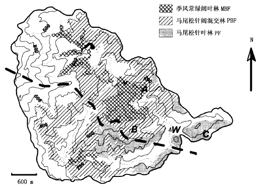
图1 鼎湖山自然保护区林型分布图
Fig.1 Forest distribution in Dinghushan biosphere reserve
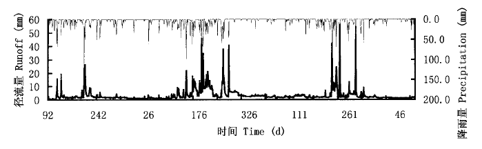
图2 鼎湖山东沟集水区日径流量和降水量 (2000年4月~2003年3月)
Fig.2 Daily runoff and precipitation in eastern watershed of Dinghushan biosphere reserve during Apr. 2000-Mar. 2003
| 年份 Year | 干湿季 Season | n1 | n2 | Rss (mm) | Rsf (mm) | Rss+Rsf (mm) | P (mm) | RssRss+RsfRssRss+Rsf | RssPRssΡ | RsfPRsfΡ | Rss+RsfPRss+RsfΡ |
|---|---|---|---|---|---|---|---|---|---|---|---|
| 2000年4月~2001年3月 Apr.2000-Mar.2001 | 湿季 Wet season | 94 | 89 | 358.8 | 150.2 | 509.0 | 1 178.9 | 0.705 | 0.304 | 0.127 | 0.432 |
| 干季 Dry season | 129 | 53 | 197.5 | 32.7 | 230.2 | 512.1 | 0.858 | 0.386 | 0.064 | 0.450 | |
| 2001年4月~2002年3月 Apr.2001-Mar.2002 | 湿季 Wet season | 81 | 102 | 845.6 | 408.4 | 1 254.0 | 1 737.2 | 0.674 | 0.487 | 0.235 | 0.722 |
| 干季 Dry season | 141 | 41 | 481.3 | 15.1 | 496.4 | 206.3 | 0.970 | 2.333 | 0.073 | 2.406 | |
| 2002年4月~2003年3月 Apr.2002-Mar.2003 | 湿季 Wet season | 102 | 81 | 515.5 | 232.9 | 748.4 | 1 271.8 | 0.689 | 0.405 | 0.183 | 0.588 |
| 干季 Dry season | 122 | 60 | 364.7 | 25.6 | 390.3 | 548.1 | 0.934 | 0.665 | 0.047 | 0.712 | |
| 总和 Total | 669 | 426 | 2 894.2 | 734.1 | 3 628.3 | 5 454.4 | / | / | / | / |
表1 东沟集水区式 (1) 的各项参数
Table 1 Parameters in Eq (1) for the eastern watershed
| 年份 Year | 干湿季 Season | n1 | n2 | Rss (mm) | Rsf (mm) | Rss+Rsf (mm) | P (mm) | RssRss+RsfRssRss+Rsf | RssPRssΡ | RsfPRsfΡ | Rss+RsfPRss+RsfΡ |
|---|---|---|---|---|---|---|---|---|---|---|---|
| 2000年4月~2001年3月 Apr.2000-Mar.2001 | 湿季 Wet season | 94 | 89 | 358.8 | 150.2 | 509.0 | 1 178.9 | 0.705 | 0.304 | 0.127 | 0.432 |
| 干季 Dry season | 129 | 53 | 197.5 | 32.7 | 230.2 | 512.1 | 0.858 | 0.386 | 0.064 | 0.450 | |
| 2001年4月~2002年3月 Apr.2001-Mar.2002 | 湿季 Wet season | 81 | 102 | 845.6 | 408.4 | 1 254.0 | 1 737.2 | 0.674 | 0.487 | 0.235 | 0.722 |
| 干季 Dry season | 141 | 41 | 481.3 | 15.1 | 496.4 | 206.3 | 0.970 | 2.333 | 0.073 | 2.406 | |
| 2002年4月~2003年3月 Apr.2002-Mar.2003 | 湿季 Wet season | 102 | 81 | 515.5 | 232.9 | 748.4 | 1 271.8 | 0.689 | 0.405 | 0.183 | 0.588 |
| 干季 Dry season | 122 | 60 | 364.7 | 25.6 | 390.3 | 548.1 | 0.934 | 0.665 | 0.047 | 0.712 | |
| 总和 Total | 669 | 426 | 2 894.2 | 734.1 | 3 628.3 | 5 454.4 | / | / | / | / |
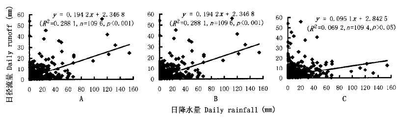
图3 东沟集水区日降水量和径流量的相关性 A: 同一天的降水量和径流量 The rainfall and runoff in the same day B: 第一天降水量与第二天径流量 The rainfall in a day and runoff in the next day C: 第一天降水量与第三天径流量 Rainfall in a day and runoff in the next second day
Fig.3 The correlation of daily rainfall and runoff for the eastern watershed
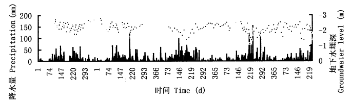
图4 鼎湖山地下水位与日大气降水量的比较
Fig.4 Comparison of groundwater level and daily precipitation in Dinghushan biosphere reserve
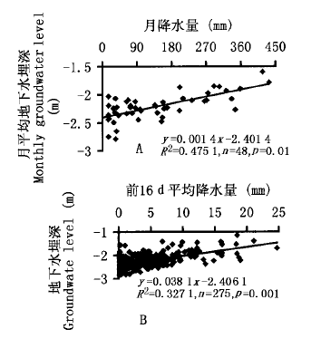
图5 地下水位与不同周期平均降水量之间的相关性
Fig.5 The correlation of groundwater level with the average rainfall of different periods
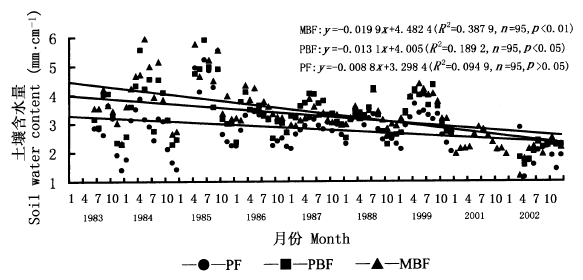
图6 3个森林类型多年月土壤含水量 PBF、MBF:见图1
Fig.6 Monthly soil water content in the three forest types during 1983-2002 PF、 See Fig.1
| 时段 Periods | 1983~1985 | 1986~1999 | 2001~2002 | |||||
|---|---|---|---|---|---|---|---|---|
| 平均值Mean (mm·cm-1) | 标准差δ | 平均值Mean (mm·cm-1) | 标准差δ | 平均值Mean (mm·cm-1) | 标准差δ | |||
| 马尾松针叶林PF | 3.11 | 1.11 | 2.87 | 0.44 | 1.89 | 0.45 | ||
| 马尾松针阔混交林PBF | 3.73 | 1.02 | 3.33 | 0.53 | 2.09 | 0.27 | ||
| 季风常绿阔叶林MBF | 4.12 | 1.01 | 3.42 | 0.44 | 2.20 | 0.35 | ||
表2 3个森林类型不同时期土壤含水量的平均值和标准差
Table 2 Average and standard deviation (δ) of soil water content for the three forests types in different periods
| 时段 Periods | 1983~1985 | 1986~1999 | 2001~2002 | |||||
|---|---|---|---|---|---|---|---|---|
| 平均值Mean (mm·cm-1) | 标准差δ | 平均值Mean (mm·cm-1) | 标准差δ | 平均值Mean (mm·cm-1) | 标准差δ | |||
| 马尾松针叶林PF | 3.11 | 1.11 | 2.87 | 0.44 | 1.89 | 0.45 | ||
| 马尾松针阔混交林PBF | 3.73 | 1.02 | 3.33 | 0.53 | 2.09 | 0.27 | ||
| 季风常绿阔叶林MBF | 4.12 | 1.01 | 3.42 | 0.44 | 2.20 | 0.35 | ||
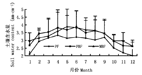
图7 3种林型的土壤含水量年内变化 PF、PBF、MBF:见图1
Fig.7 Annual change of soil water content for the three forest types See Fig.1
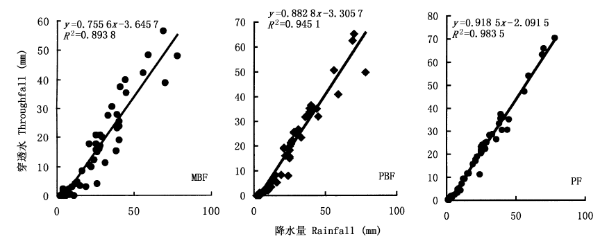
图8 3种林型的穿透水和大气降水之间关系 PF、PBF、MBF:见图1
Fig.8 The relationship between throughfall and rainfall for the three forest types See Fig.1
| 林型 Forest types | 季风常绿阔叶林MBF | 马尾松针阔混交林PBF | 马尾松针叶林PF |
|---|---|---|---|
| 叶面积指数Leaf area index | 17.76±1.2 | 11.28±1.6 | 6.61±2.1 |
| 郁闭度Canopy cover | 93% | 86% | 58% |
表3 3种林型的叶面积指数和郁闭度
Table 3 Leaf area index and canopy cover of three forest types
| 林型 Forest types | 季风常绿阔叶林MBF | 马尾松针阔混交林PBF | 马尾松针叶林PF |
|---|---|---|---|
| 叶面积指数Leaf area index | 17.76±1.2 | 11.28±1.6 | 6.61±2.1 |
| 郁闭度Canopy cover | 93% | 86% | 58% |

图9 马尾松针叶林和马尾松针阔混交林内 马尾松年树干茎流量与胸径的关系 PF、PBF:见图1
Fig.9 The relationship between annual stem flow and diameter at breast height (DBH) for masson pines (Pinus massoniana) growing in PF and PBF See Fig.1
| 林型 Forest types | 马尾松针叶林PF | 马尾松针阔混交林PBF | 季风常绿阔叶林MBF |
|---|---|---|---|
| 降雨量 Rainfall (%) | 100.0 | 100.0 | 100.0 |
| 穿透水 Throughfall (%) | 83.4±9.2 | 68.3±8.6 | 59.9±3.5 |
| 树干茎流 Stemflow (%) | 1.9±1.1 | 6.5±1.6 | 8.3±1.1 |
| 林冠截留 Interception (%) | 14.7±9.3 | 25.2±8.7 | 31.8±3.7 |
表4 鼎湖山3种林型中降水的林内分配状况 (1998~2003)
Table 4 Distribution pattern of rainfall by the canopy for three forest types in Dinghushan from 1998-2003
| 林型 Forest types | 马尾松针叶林PF | 马尾松针阔混交林PBF | 季风常绿阔叶林MBF |
|---|---|---|---|
| 降雨量 Rainfall (%) | 100.0 | 100.0 | 100.0 |
| 穿透水 Throughfall (%) | 83.4±9.2 | 68.3±8.6 | 59.9±3.5 |
| 树干茎流 Stemflow (%) | 1.9±1.1 | 6.5±1.6 | 8.3±1.1 |
| 林冠截留 Interception (%) | 14.7±9.3 | 25.2±8.7 | 31.8±3.7 |
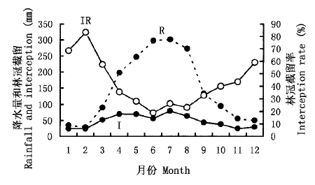
图10 季风常绿阔叶林降水 (R) 、截留 (I) 、截留率 (IR) 的月变化
Fig.10 Monthly changes of rainfall (R), interception (I) and interception rate (IR) in MBF
| [1] | Aboal JR, Morales D, Hernandez M, Jimenez MS (1999). ThemeasurementandmodelingofthevariationofstemflowinalaurelforestinTenerife, CanaryIslands. JournalofHy drology, 221,161-175. |
| [2] | Bosch JM, Hewlett JD (1982). Areviewofcatchmentexperi mentstodeterminetheeffectofvegetationchangesonwateryieldandevapotranspiration. JournalofHydrology, 55,3-23. |
| [3] | Carlyle-Moses DE, Price AG (1999). AnevaluationoftheGashinterceptionmodelinanorthernhardwoodstand. JournalofHydrology, 214,103-110. |
| [4] | Fang YT (方运霆), Mo JM (莫江明), Zhang QM (张倩媚), Zhang YC (张佑昌), Xu GL (徐国良) (2002). SoilcarbonstorageanddistributionforthreetypesofForestsinDinghushan. TropicalandSubtropicalForestEcosystem (热带亚热带森林生态系统研究), 9,115-124. (inChinesewithEnglishabstract). |
| [5] | Gash JHC, Morton AJ (1978). AnapplicationoftheRuttermodeltotheestimationoftheinterceptionlossfromThetfordforest. JournalofHydrology, 38,49-58. |
| [6] | Haworth K, McPherson GR (1995). EffectsofQuercuse moryitreesonprecipitationdistributionandmicroclimateinasemi_aridsavanna. JournalofAridEnvironment, 31,153-170. |
| [7] | Helvey JD (1967). Interceptionbyeasternwhitepine. WaterResourcesResearch, 3,723-729. |
| [8] | Helvey JD, Patric JH (1965). CanopyandlitterinterceptionofrainfallbyhardwoodsofeasternUnitedStates. WaterRe sourcesResearch, 1,193-206. |
| [9] | Levia DF, Frost E (2003). Areviewandevaluationofstem flowliteratureinthehydrologicandbiogeochemicalcyclesofforestedandagriculturalecosystems. JournalofHydrology, 274,1-29. |
| [10] | Mo JM (莫江明), Brown S, Kong GH (孔国辉), Lenart M, Zhang YC (张佑昌) (1997). LitterdecompositionanditsnutrientdynamicsofapineforestinDinghushanBiosphereReserve. ActaPhytoecologicaSinica (植物生态学报), 20,534-542. (inChinesewithEnglishabstract). |
| [11] | Nyholm T, Rasmussen KR, Christensen S (2003). Estimationofstreamflowdepletionanduncertaintyfromdischargemea surementsinasmallalluvialstream. JournalofHydrology, 274,129-144. |
| [12] | Peng SL (彭少麟), Fang W (方炜) (1995). Studiesondy namicsofCastanopsischinensisandSchimasuperbapopula tioninforestsuccessionofDinghushanMountain. ActaPhy toecologicaSinica (植物生态学报), 19,311-318. (inChi nesewithEnglishabstract). |
| [13] | Sarmiento JL, Gruber N (2002). Sinksforanthropogeniccar bon. PhysicsToday, 8,30-36. |
| [14] |
Schimel DS, Ciasis P, Peylin P (2001). Recentpatternsandmechanismsofcarbonexchangebyterrestrialecosystems. Nature, 414,169-172.
PMID |
| [15] |
Swank WT, Douglass JE (1974). Streamflow greatlyreducedbyconvertingdeciduoushardwoodstandstopine. Science, 185,857-859.
DOI URL |
| [16] | Tallaksen LM (1995). Areviewofbaseflowrecessionanalysis. JournalofHydrology, 165,349-370. |
| [17] | Wen DZ (温达志), Wei P (魏平), Zhang QM (张倩媚), Kong GH (孔国辉) (1999). Studiesonbiomassofthreelowersubtropicalev ergreenbroad-leavedforestsinaMabReserveofSouthChina. ActaPhytoecologicaSinica (植物生态学报), 23 (Suppl.),11-21. (inChinesewithEnglishabstract). |
| [18] | Wu HS (吴厚水), Liu HP (刘慧屏), Huang DJ (黄大基) (1998). Theinterceptioneffectofthemonsoonevergreenbroad-leavedforestonprecipitationinDinghushanBiosphereReserve. TropicalandSubtropicalForestEcosystem (热带亚热带森林生态系统研究), 8,146-149. (inChinesewithEnglishabstract). |
| [19] | Zhou GY, Morris JD, Yan JH, Yu ZY, Peng SL (2002a). Hydrologicalimpactsofreafforestationwitheucalyptusandindigenousspecies:acasestudyinsouthernChina. ForestE cologyandManagement, 167,209-222. |
| [20] |
Zhou GY, Wei XH, Yan JH (2002b). Impactsofeucalyptus (Eucalyptusexserta) plantationonsedimentyieldinGuang dongprovince, SouthernChina———akineticenergyap proach. CATENA, 49,231-251.
DOI URL |
| [21] | Zhou GY (周国逸) (1997). PrinciplesandApplicationsofWaterandHeatinEcosystem (生态系统水热原理及其应用). ChinaMeteorologicalPress, Beijing. (inChinese). |
| [1] | 祝维, 周欧, 孙一鸣, 古丽米热·依力哈木, 王亚飞, 杨红青, 贾黎明, 席本野. 混交林内毛白杨和刺槐根系吸水的动态生态位划分[J]. 植物生态学报, 2023, 47(3): 389-403. |
| [2] | 李万年, 罗益敏, 黄则月, 杨梅. 望天树人工幼林混交对土壤微生物功能多样性与碳源利用的影响[J]. 植物生态学报, 2022, 46(9): 1109-1124. |
| [3] | 冯印成, 王云琦, 王玉杰, 王凯, 王松年, 王杰帅. 重庆缙云山针阔混交林水汽通量特征及其影响因子[J]. 植物生态学报, 2022, 46(8): 890-903. |
| [4] | 魏龙鑫, 耿燕, 崔可达, 乔雪涛, 岳庆敏, 范春雨, 张春雨, 赵秀海. 阔叶红松林不同林层和生长阶段树木生长对采伐强度的响应[J]. 植物生态学报, 2022, 46(6): 642-655. |
| [5] | 张敏, 朱教君. 光温条件对不同种源红松种子萌发的影响[J]. 植物生态学报, 2022, 46(6): 613-623. |
| [6] | 秦江环, 张春雨, 赵秀海. 基于温带针阔混交林植物-土壤反馈的Janzen- Connell假说检验[J]. 植物生态学报, 2022, 46(6): 624-631. |
| [7] | 郝建锋, 周润惠, 姚小兰, 喻静, 陈聪琳, 向琳, 王姚瑶, 苏天成, 齐锦秋. 二代野猪放牧对夹金山针阔混交林物种多样性与土壤理化性质的影响[J]. 植物生态学报, 2022, 46(2): 197-207. |
| [8] | 宋语涵, 张鹏, 金光泽. 阔叶红松林不同演替阶段灌木叶片碳氮磷化学计量特征及其影响因素[J]. 植物生态学报, 2021, 45(9): 952-960. |
| [9] | 贺忠权, 刘长成, 蔡先立, 郭柯. 黔中高原喀斯特常绿与落叶阔叶混交林类型及群落特征[J]. 植物生态学报, 2021, 45(6): 670-680. |
| [10] | 孙浩哲, 王襄平, 张树斌, 吴鹏, 杨蕾. 阔叶红松林不同演替阶段凋落物产量及其稳定性的影响因素[J]. 植物生态学报, 2021, 45(6): 594-605. |
| [11] | 贺露炎, 侯满福, 唐伟, 刘雨婷, 赵俊. 滇东菌子山喀斯特森林的植被类型及其特征[J]. 植物生态学报, 2021, 45(12): 1380-1390. |
| [12] | 哈努拉•塔斯肯, 蔡慧颖, 金光泽. 树冠结构对典型阔叶红松林生产力的影响[J]. 植物生态学报, 2021, 45(1): 38-50. |
| [13] | 方文静, 蔡琼, 朱江玲, 吉成均, 岳明, 郭卫华, 张峰, 高贤明, 唐志尧, 方精云. 华北地区落叶松林的分布、群落结构和物种多样性[J]. 植物生态学报, 2019, 43(9): 742-752. |
| [14] | 王进, 朱江, 艾训儒, 姚兰, 黄小, 吴漫玲, 朱强, 洪建峰. 湖北星斗山地形变化对不同生活型植物叶功能性状的影响[J]. 植物生态学报, 2019, 43(5): 447-457. |
| [15] | 高思涵, 葛珏希, 周李奕, 朱宝琳, 葛星宇, 李凯, 倪健. 测定森林树木叶面积的最适叶片数是多少?[J]. 植物生态学报, 2018, 42(9): 917-925. |
| 阅读次数 | ||||||
|
全文 |
|
|||||
|
摘要 |
|
|||||
Copyright © 2022 版权所有 《植物生态学报》编辑部
地址: 北京香山南辛村20号, 邮编: 100093
Tel.: 010-62836134, 62836138; Fax: 010-82599431; E-mail: apes@ibcas.ac.cn, cjpe@ibcas.ac.cn
备案号: 京ICP备16067583号-19