
植物生态学报 ›› 2008, Vol. 32 ›› Issue (4): 838-847.DOI: 10.3773/j.issn.1005-264x.2008.04.012
郝兴明1,2, 李卫红1,2, 陈亚宁1,2,*( )
)
收稿日期:2007-04-25
接受日期:2007-10-30
出版日期:2008-04-25
发布日期:2008-07-30
通讯作者:
陈亚宁
作者简介:*E-mail:chenyn@ms.xjb.ac.cn基金资助:
HAO Xing-Ming1,2, LI Wei-Hong1,2, and CHEN Ya-Ning1,2,*()
Received:2007-04-25
Accepted:2007-10-30
Online:2008-04-25
Published:2008-07-30
Contact:
and CHEN Ya-Ning
摘要:
该文依据塔里木河下游地下水位多年监测资料, 将地下水位按不同埋深划分为0~2、2~4、4~6、6~8、8~10和>10 m 6个梯度, 并设置植被调查样方进行连续监测, 以分析地下水位变化对植物物种多样性与种群生态位的影响。研究结果表明: 在地下水位2~4 m时, 物种多样性最高, 其次为4~6 m, 再次为0~2 m; 当地下水位在6 m以下时, 物种多样性锐减, Hill多样性指数曲线变化趋势趋于平直化。荒漠河岸(林)植被主要植物种群生态位随着地下水位的逐步下降而扩展, 并在地下水位4~6 m处达到最宽; 尔后, 生态位又显著变窄; 地下水位4~6 m时, 种群间生态位重叠最不显著, 物种数较为丰富。因此, 该文分析得出结论: 塔里木河下游植被恢复的地下水位应确保达到6 m以上, 大部分地区地下水位应维持在4~6 m, 而部分河道附近地区地下水位争取达到2~4 m。
郝兴明, 李卫红, 陈亚宁. 新疆塔里木河下游荒漠河岸(林)植被合理生态水位. 植物生态学报, 2008, 32(4): 838-847. DOI: 10.3773/j.issn.1005-264x.2008.04.012
HAO Xing-Ming, LI Wei-Hong, and CHEN Ya-Ning. WATER TABLE AND THE DESERT RIPARIAN FOREST COMMUNITY IN THE LOWER REACHES OF TARIM RIVER, CHINA. Chinese Journal of Plant Ecology, 2008, 32(4): 838-847. DOI: 10.3773/j.issn.1005-264x.2008.04.012
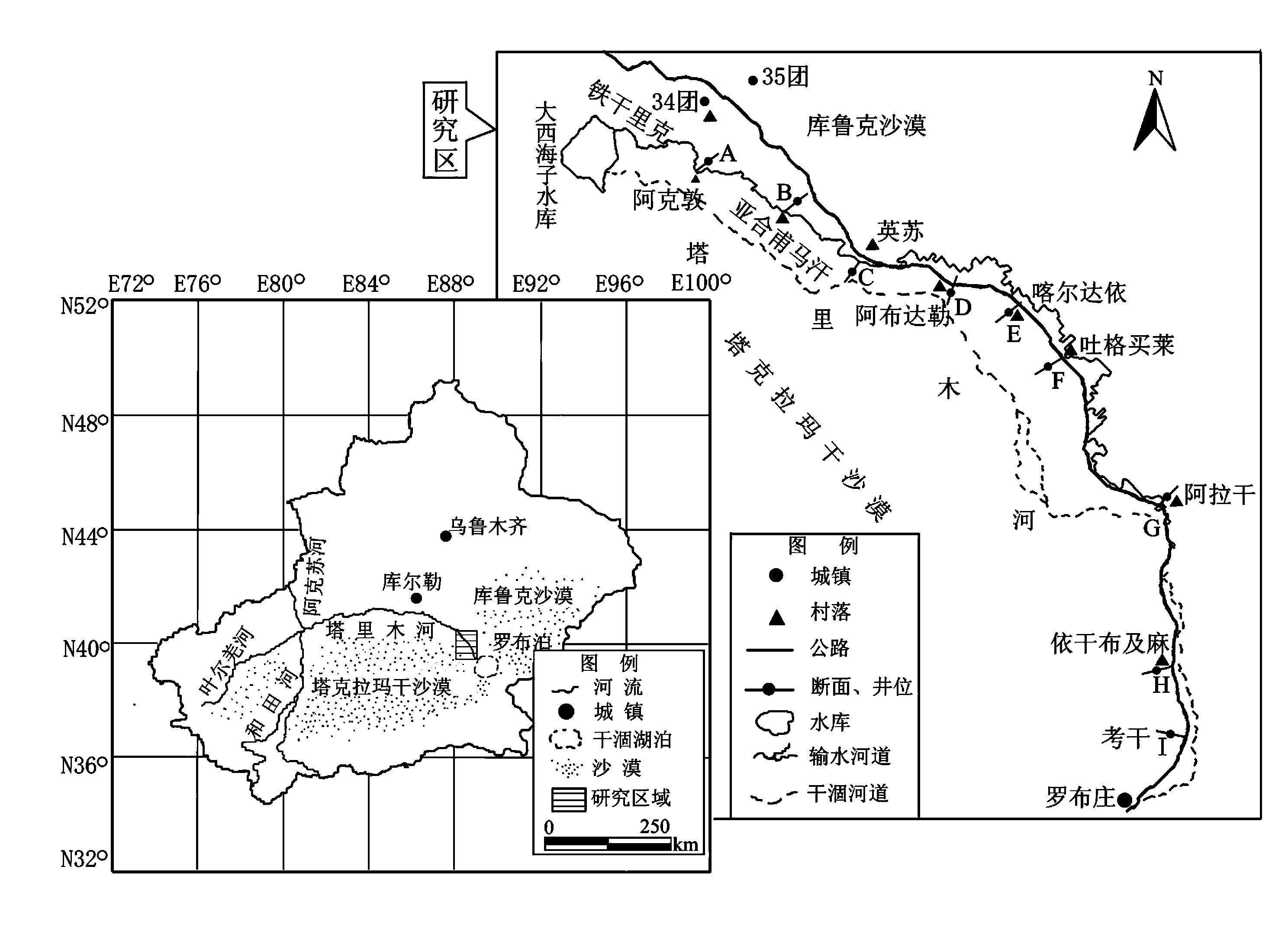
图1 研究区域图
Fig. 1 The map of study area
| 编号 Number | 种名 Species | 编号 Number | 种名 Species |
|---|---|---|---|
| 1 | 多枝柽柳 Tamarix ramosissima | 11 | 猪毛菜 Salsola sp. |
| 2 | 胀果甘草 Glycyrrhiza inflata | 12 | 白刺 Nitraria sibirica |
| 3 | 刚毛柽柳 T.hispida | 13 | 刺沙蓬 Salsola ruthenica |
| 4 | 黑刺 Lycium ruthenicum | 14 | 假苇拂子茅 Calamagrostis pseudophragmites |
| 5 | 胡杨 Populus euphratica | 15 | 河西苣 Hexinia polydichotoma |
| 6 | 花花柴 Karelinia caspica | 16 | 蓼子朴 Inula salsoloides |
| 7 | 铃铛刺 Halimodendron halodendron | 17 | 牛皮消 Cynanchum sibiricum |
| 8 | 芦苇 Phragmites communis | 18 | 沙枣 Elaeagnus angustifolia |
| 9 | 大花罗布麻 Apocynum venetum | 19 | 小獐毛 Aeluropus pungens |
| 10 | 疏叶骆驼刺 Alhagi sparsifolia |
表1 塔里木河下游19种植物名录
Table 1 The list of 19 species in the lower reaches of Tarim River
| 编号 Number | 种名 Species | 编号 Number | 种名 Species |
|---|---|---|---|
| 1 | 多枝柽柳 Tamarix ramosissima | 11 | 猪毛菜 Salsola sp. |
| 2 | 胀果甘草 Glycyrrhiza inflata | 12 | 白刺 Nitraria sibirica |
| 3 | 刚毛柽柳 T.hispida | 13 | 刺沙蓬 Salsola ruthenica |
| 4 | 黑刺 Lycium ruthenicum | 14 | 假苇拂子茅 Calamagrostis pseudophragmites |
| 5 | 胡杨 Populus euphratica | 15 | 河西苣 Hexinia polydichotoma |
| 6 | 花花柴 Karelinia caspica | 16 | 蓼子朴 Inula salsoloides |
| 7 | 铃铛刺 Halimodendron halodendron | 17 | 牛皮消 Cynanchum sibiricum |
| 8 | 芦苇 Phragmites communis | 18 | 沙枣 Elaeagnus angustifolia |
| 9 | 大花罗布麻 Apocynum venetum | 19 | 小獐毛 Aeluropus pungens |
| 10 | 疏叶骆驼刺 Alhagi sparsifolia |
| 物种 Species | 编号Number | 地下水位 Groundwater table | |||||
|---|---|---|---|---|---|---|---|
| 0~2 m | 2~4 m | 4~6 m | 6~8 m | 8~10 m | >10 m | ||
| 生态位宽度 Niche breadth | |||||||
| 多枝柽柳 Tamarix ramosissima | 1 | 0 | 1.92 | 3.2 | 2.57 | 2.15 | 1.51 |
| 胀果甘草 Glycyrrhiza inflata | 2 | 0.64 | 2.49 | 2 | 0.69 | ||
| 刚毛柽柳 T.hispida | 3 | 1.31 | 2.99 | 1.76 | 0 | 0 | |
| 黑刺 Lycium ruthenicum | 4 | 0 | 2.54 | 1.69 | 0.87 | ||
| 胡杨 Populus euphratica | 5 | 0 | 2.33 | 2.79 | 1.93 | 1.35 | |
| 花花柴 Karelinia caspica | 6 | 1.39 | 1.41 | 0.69 | |||
| 铃铛刺 Halimodendron halodendron | 7 | 1.1 | 2.37 | 0.69 | |||
| 芦苇 Phragmites communis | 8 | 0.34 | 1.52 | 2.05 | |||
| 大花罗布麻 Apocynum venetum | 9 | 0 | 1.73 | 2.05 | 0.69 | 0 | |
| 疏叶骆驼刺 Alhagi sparsifolia | 10 | 0.63 | 1.88 | 2.41 | 1.37 | ||
| 猪毛菜 Salsolasp. | 11 | 0.66 | 0.68 | 0.69 | |||
| 白刺 Nitraria sibirica | 12 | 0.67 | 0.68 | ||||
| 刺沙蓬 Salsola ruthenica | 13 | 0.67 | |||||
| 拂子茅 Calamagrostis pseudophragmites | 14 | 0 | |||||
| 河西苣 Hexinia polydichotoma | 15 | 1.41 | 0 | ||||
| 蓼子朴 Inula salsoloides | 16 | 0.69 | |||||
| 牛皮消 Cynanchum sibiricum | 17 | 0 | 0 | ||||
| 沙枣 Elaeagnus angustifolia | 18 | 0.98 | |||||
| 小獐毛 Aeluropus pungens | 19 | 1.08 | |||||
表2 塔里木河下游不同地下水位梯度下物种生态位宽度
Table 2 The coefficient of niche breadth along different groundwater table in the lower reach of Tarim River
| 物种 Species | 编号Number | 地下水位 Groundwater table | |||||
|---|---|---|---|---|---|---|---|
| 0~2 m | 2~4 m | 4~6 m | 6~8 m | 8~10 m | >10 m | ||
| 生态位宽度 Niche breadth | |||||||
| 多枝柽柳 Tamarix ramosissima | 1 | 0 | 1.92 | 3.2 | 2.57 | 2.15 | 1.51 |
| 胀果甘草 Glycyrrhiza inflata | 2 | 0.64 | 2.49 | 2 | 0.69 | ||
| 刚毛柽柳 T.hispida | 3 | 1.31 | 2.99 | 1.76 | 0 | 0 | |
| 黑刺 Lycium ruthenicum | 4 | 0 | 2.54 | 1.69 | 0.87 | ||
| 胡杨 Populus euphratica | 5 | 0 | 2.33 | 2.79 | 1.93 | 1.35 | |
| 花花柴 Karelinia caspica | 6 | 1.39 | 1.41 | 0.69 | |||
| 铃铛刺 Halimodendron halodendron | 7 | 1.1 | 2.37 | 0.69 | |||
| 芦苇 Phragmites communis | 8 | 0.34 | 1.52 | 2.05 | |||
| 大花罗布麻 Apocynum venetum | 9 | 0 | 1.73 | 2.05 | 0.69 | 0 | |
| 疏叶骆驼刺 Alhagi sparsifolia | 10 | 0.63 | 1.88 | 2.41 | 1.37 | ||
| 猪毛菜 Salsolasp. | 11 | 0.66 | 0.68 | 0.69 | |||
| 白刺 Nitraria sibirica | 12 | 0.67 | 0.68 | ||||
| 刺沙蓬 Salsola ruthenica | 13 | 0.67 | |||||
| 拂子茅 Calamagrostis pseudophragmites | 14 | 0 | |||||
| 河西苣 Hexinia polydichotoma | 15 | 1.41 | 0 | ||||
| 蓼子朴 Inula salsoloides | 16 | 0.69 | |||||
| 牛皮消 Cynanchum sibiricum | 17 | 0 | 0 | ||||
| 沙枣 Elaeagnus angustifolia | 18 | 0.98 | |||||
| 小獐毛 Aeluropus pungens | 19 | 1.08 | |||||
| 编号Number | 地下水位 Groundwater table (m) | |||||||||||||||||||||||||||||||||||
|---|---|---|---|---|---|---|---|---|---|---|---|---|---|---|---|---|---|---|---|---|---|---|---|---|---|---|---|---|---|---|---|---|---|---|---|---|
| 0~2 | 2~4 | 4~6 | ||||||||||||||||||||||||||||||||||
| 2 | 4 | 5 | 8 | 9 | 10 | 2 | 3 | 5 | 6 | 7 | 8 | 9 | 10 | 11 | 2 | 3 | 4 | 5 | 6 | |||||||||||||||||
| 1 | 0.34 | 0.61 | 0.82 | 0.11 | 0.00 | 0.67 | 0.46 | 0.63 | 0.57 | 0.19 | 0.08 | 0.06 | 0.30 | 0.30 | 0.12 | 0.14 | 0.45 | 0.28 | 0.34 | 0.19 | ||||||||||||||||
| 2 | 0.73 | 0.52 | 0.77 | 0.66 | 0.67 | 0.31 | 0.70 | 0.16 | 0.33 | 0.35 | 0.19 | 0.35 | 0.05 | 0.27 | 0.13 | 0.12 | 0.00 | |||||||||||||||||||
| 3 | 0.31 | 0.00 | 0.00 | 0.03 | 0.14 | 0.22 | 0.00 | 0.35 | 0.19 | 0.14 | ||||||||||||||||||||||||||
| 4 | 0.80 | 0.49 | 0.39 | 0.94 | 0.05 | 0.00 | ||||||||||||||||||||||||||||||
| 5 | 0.29 | 0.18 | 0.85 | 0.32 | 0.37 | 0.12 | 0.32 | 0.26 | 0.16 | 0.10 | ||||||||||||||||||||||||||
| 6 | 0.00 | 0.20 | 0.50 | 0.39 | 0.47 | |||||||||||||||||||||||||||||||
| 7 | 0.00 | 0.00 | 0.00 | 0.00 | ||||||||||||||||||||||||||||||||
| 8 | 0.89 | 0.44 | 0.36 | 0.46 | 0.02 | |||||||||||||||||||||||||||||||
| 9 | 0.33 | 0.61 | 0.24 | |||||||||||||||||||||||||||||||||
| 10 | 0.23 | |||||||||||||||||||||||||||||||||||
| 编号Number | 地下水位 Groundwater table (m) | |||||||||||||||||||||||||||||||||||
| 4~6 | 6~8 | 8~10 | >10 | |||||||||||||||||||||||||||||||||
| 6 | 7 | 8 | 9 | 10 | 11 | 3 | 4 | 5 | 7 | 9 | 11 | 2 | 3 | 4 | 5 | 6 | 9 | 10 | 3 | |||||||||||||||||
| 1 | 0.19 | 0.30 | 0.19 | 0.19 | 0.30 | 0.06 | 0.31 | 0.42 | 0.30 | 0.04 | 0.17 | 0.10 | 0.20 | 0.07 | 0.33 | 0.39 | 0.20 | 0.13 | 0.44 | 0.05 | ||||||||||||||||
| 2 | 0.00 | 0.12 | 0.44 | 0.35 | 0.49 | 0.00 | 0.37 | 0.21 | 0.34 | 0.00 | 0.37 | 0.10 | 0.81 | 0.33 | 0.20 | 0.98 | 0.10 | |||||||||||||||||||
| 3 | 0.14 | 0.28 | 0.15 | 0.38 | 0.32 | 0.00 | 0.12 | 0.12 | 0.10 | 0.06 | 0.06 | 0.33 | 0.10 | 0.00 | 0.10 | |||||||||||||||||||||
| 4 | 0.00 | 0.68 | 0.24 | 0.25 | 0.29 | 0.00 | 0.15 | 0.20 | 0.10 | 0.10 | ||||||||||||||||||||||||||
| 5 | 0.10 | 0.06 | 0.14 | 0.07 | 0.15 | 0.09 | 0.21 | 0.00 | 0.00 | 0.20 | 0.10 | 0.20 | ||||||||||||||||||||||||
| 6 | 0.08 | 0.25 | 0.23 | 0.12 | 0.00 | 0.10 | 0.54 | |||||||||||||||||||||||||||||
| 7 | 0.14 | 0.33 | 0.27 | 0.00 | 0.00 | 0.00 | ||||||||||||||||||||||||||||||
| 8 | 0.00 | 0.44 | 0.00 | |||||||||||||||||||||||||||||||||
| 9 | 0.22 | 0.00 | 0.00 | 0.10 | ||||||||||||||||||||||||||||||||
| 10 | 0.04 | |||||||||||||||||||||||||||||||||||
表3 塔里木河下游不同地下水位梯度下主要种群生态位重叠
Table 3 The coefficient of niche overlap along different groundwater table in the lower reach of Tarim River
| 编号Number | 地下水位 Groundwater table (m) | |||||||||||||||||||||||||||||||||||
|---|---|---|---|---|---|---|---|---|---|---|---|---|---|---|---|---|---|---|---|---|---|---|---|---|---|---|---|---|---|---|---|---|---|---|---|---|
| 0~2 | 2~4 | 4~6 | ||||||||||||||||||||||||||||||||||
| 2 | 4 | 5 | 8 | 9 | 10 | 2 | 3 | 5 | 6 | 7 | 8 | 9 | 10 | 11 | 2 | 3 | 4 | 5 | 6 | |||||||||||||||||
| 1 | 0.34 | 0.61 | 0.82 | 0.11 | 0.00 | 0.67 | 0.46 | 0.63 | 0.57 | 0.19 | 0.08 | 0.06 | 0.30 | 0.30 | 0.12 | 0.14 | 0.45 | 0.28 | 0.34 | 0.19 | ||||||||||||||||
| 2 | 0.73 | 0.52 | 0.77 | 0.66 | 0.67 | 0.31 | 0.70 | 0.16 | 0.33 | 0.35 | 0.19 | 0.35 | 0.05 | 0.27 | 0.13 | 0.12 | 0.00 | |||||||||||||||||||
| 3 | 0.31 | 0.00 | 0.00 | 0.03 | 0.14 | 0.22 | 0.00 | 0.35 | 0.19 | 0.14 | ||||||||||||||||||||||||||
| 4 | 0.80 | 0.49 | 0.39 | 0.94 | 0.05 | 0.00 | ||||||||||||||||||||||||||||||
| 5 | 0.29 | 0.18 | 0.85 | 0.32 | 0.37 | 0.12 | 0.32 | 0.26 | 0.16 | 0.10 | ||||||||||||||||||||||||||
| 6 | 0.00 | 0.20 | 0.50 | 0.39 | 0.47 | |||||||||||||||||||||||||||||||
| 7 | 0.00 | 0.00 | 0.00 | 0.00 | ||||||||||||||||||||||||||||||||
| 8 | 0.89 | 0.44 | 0.36 | 0.46 | 0.02 | |||||||||||||||||||||||||||||||
| 9 | 0.33 | 0.61 | 0.24 | |||||||||||||||||||||||||||||||||
| 10 | 0.23 | |||||||||||||||||||||||||||||||||||
| 编号Number | 地下水位 Groundwater table (m) | |||||||||||||||||||||||||||||||||||
| 4~6 | 6~8 | 8~10 | >10 | |||||||||||||||||||||||||||||||||
| 6 | 7 | 8 | 9 | 10 | 11 | 3 | 4 | 5 | 7 | 9 | 11 | 2 | 3 | 4 | 5 | 6 | 9 | 10 | 3 | |||||||||||||||||
| 1 | 0.19 | 0.30 | 0.19 | 0.19 | 0.30 | 0.06 | 0.31 | 0.42 | 0.30 | 0.04 | 0.17 | 0.10 | 0.20 | 0.07 | 0.33 | 0.39 | 0.20 | 0.13 | 0.44 | 0.05 | ||||||||||||||||
| 2 | 0.00 | 0.12 | 0.44 | 0.35 | 0.49 | 0.00 | 0.37 | 0.21 | 0.34 | 0.00 | 0.37 | 0.10 | 0.81 | 0.33 | 0.20 | 0.98 | 0.10 | |||||||||||||||||||
| 3 | 0.14 | 0.28 | 0.15 | 0.38 | 0.32 | 0.00 | 0.12 | 0.12 | 0.10 | 0.06 | 0.06 | 0.33 | 0.10 | 0.00 | 0.10 | |||||||||||||||||||||
| 4 | 0.00 | 0.68 | 0.24 | 0.25 | 0.29 | 0.00 | 0.15 | 0.20 | 0.10 | 0.10 | ||||||||||||||||||||||||||
| 5 | 0.10 | 0.06 | 0.14 | 0.07 | 0.15 | 0.09 | 0.21 | 0.00 | 0.00 | 0.20 | 0.10 | 0.20 | ||||||||||||||||||||||||
| 6 | 0.08 | 0.25 | 0.23 | 0.12 | 0.00 | 0.10 | 0.54 | |||||||||||||||||||||||||||||
| 7 | 0.14 | 0.33 | 0.27 | 0.00 | 0.00 | 0.00 | ||||||||||||||||||||||||||||||
| 8 | 0.00 | 0.44 | 0.00 | |||||||||||||||||||||||||||||||||
| 9 | 0.22 | 0.00 | 0.00 | 0.10 | ||||||||||||||||||||||||||||||||
| 10 | 0.04 | |||||||||||||||||||||||||||||||||||
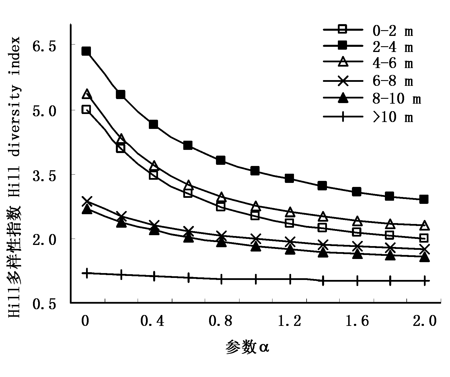
图2 塔里木河下游Hill多样性沿地下水位的变化
Fig. 2 The change trend of Hill index along groundwater gradient
| [1] | Alhamad MN (2006). Ecological and species diversity of arid Mediterranean grazing land vegetation. Journal of Arid Environments, 66,698-715. |
| [2] | Chen YJ (陈永金), Chen YN (陈亚宁), Li WH (李卫红), Liu JZ (刘加珍) (2006). Study on the groundwater chemical characteristics and rational groundwater table after eco-water conveyance in the lower reaches of Tarim River. Progress in Natural Science (自然科学进展), 16,1130-1137. (in Chinese) |
| [3] | Chen YN (陈亚宁), Li WH (李卫红), Xu HL (徐海量), Liu JZ (刘加珍), Zhang HF (张宏锋), Chen YP (陈亚鹏) (2003). The influence of groundwater on vegetation in the lower reaches of Tarim River, China. Acta Geographica Sinica (地理学报), 58,542-549. (in Chinese with English abstract) |
| [4] | Chen YN, Li WH, Chen YP, Zhang HF, Zhuang L (2004). Physiological response of natural plants to the change of groundwater level in the lower reaches of Tarim River, Xinjiang. Progress in Natural Science, 14,975-982. |
| [5] | Chen YN, Wang Q, Li WH, Ruan X, Chen YP (2006a). Rational groundwater table indicated by the eco-physiological parameters of the vegetation: a case study of ecological restoration in the lower reaches of the Tarim River. Chinese Science Bulletin, 51 (Suppl. I),8-15. |
| [6] | Chen YN, Zilliacus H, Li WH, Zhang HF, Chen YP (2006b). Groundwater level affects plant species diversity along the lower reaches of the Tarim river, Western China. Journal of Arid Environments, 66,231-246. |
| [7] | Deng W (邓伟), He Y (何岩) (1993). Discussion of groundwater effect to surface ecology. Chinese Geographical Science (地理科学), 13,161-168. (in Chinese with English abstract) |
| [8] | Fan ZL (樊自立), Ma YJ (马英杰), Zhang H (张宏), Wang RH (王让会), Zhao YJ (赵元杰), Zhou HF (周宏飞) (2004). Research of eco-water table and rational depth of groundwater of Tarim River Drainage Basin. Arid Land Geography (干旱区地理), 27 (1),8-13. (in Chinese with English abstract) |
| [9] |
Horton JL, Hart SC (1998). Hydrauliclift: a potentially important ecosystem process. Trends in Ecology and Evolution, 13,232-235.
URL PMID |
| [10] | Li YX (李跃霞), Shangguan TL (上官铁梁) (2006). Plant species diversity of woody plant communities in midpiece of Zhongtiao Mountains. Bulletin of Botanical Research (植物研究), 26,163-168. (in Chinese with English abstract) |
| [11] | Liu JZ (刘加珍), Chen YN (陈亚宁), Li WH (李卫红), Chen YJ (陈永金) (2006). The process and mechanism of degradation of desert riparian vegetation. Acta Geographica Sinica (地理学报), 61,946-956. (in Chinese with English abstract) |
| [12] | Lusk CH, Smith B (1998). Life history difference and species coexistence in an old-growth New Zealand rain forest. Ecology, 79,795-806. |
| [13] | Ma JZ (马金珠), Gao QZ (高前兆) (1997). Water resources system and eco-environmental problems in the inland river basin of arid northwest China. Journal of Land Resources and Environment (干旱区资源与环境), 11(4),15-21. (in Chinese with English abstract) |
| [14] | Patil GP, Tailie C (1979). An overview of diversity. In: Grassle, JF, Patil GP, Smith W, Tailie eds. Ecological Diversity in Theory and Practice. International Cooperative Publish House, Fairland,3-27. |
| [15] | Ruan X, Wang Q, Chen YN, Li WH (2007). Physiological response of riparian plants to watering in hyper-arid areas of Tarim River, China. Frontiers of Biology in China, doi: DOI: 10.1007/s11515-007- 0010-x, 54-61. |
| [16] | Xu HL (徐海量), Song YD (宋郁东), Chen YN (陈亚宁) (2003). Reasonable groundwater level at lower reaches of Tarim River after water transfer. Bulletin of Soil and Water Conservation (水土保持学报), 23(5),22-25. (in Chinese with English abstract) |
| [17] | Yuan JY (袁建英), Zhang JT (张金屯), Xi YX (席跃翔) (2004). Species diversity of subalpine shrub and meadow communities on Guandi Mountain, Shanxi, China. Acta Prataculturae Sinica (草业学报), 13 (3),34-39. (in Chinese with English abstract) |
| [18] | Yuan SF (袁素芬), Chen YN (陈亚宁), Li WH (李卫红) (2006). Analysis of the aboveground biomass and spatial distribution of shrubs in the lower reaches of Tarim River, Xinjiang, China. Acta Ecologica Sinica (生态学报), 26,1818-1824. (in Chinese with English abstract) |
| [19] | Zhang JT (张金屯) (2004). Quantitative Ecology (数量生态学). Sciences Press, Beijing. (in Chinese) |
| [20] | Zhang LJ (张林静), Yue M (岳明), Zhang YD (张远东), Gu FX (顾峰雪), Pan XL (潘晓玲), Zhao GF (赵桂仿) (2002a). Analysis on the niche of the main plant species of Oasis-Desert ecotone in Fukang of Xinjiang. Acta Ecologica Sinica (生态学报), 22,969-972. (in Chinese with English abstract) |
| [21] | Zhang LJ (张林静), Yue M (岳明), Zhao GF (赵桂仿), Zhang YD (张远东), Gu FX (顾峰雪), Pan XL (潘晓玲) (2002b). Comparison of different measurements applied to Oasis-Desert ecotone. Chinese Journal of Ecology (生态学杂志), 21 (4),71-75. (in Chinese with English abstract) |
| [22] | Zhuang L, Chen YN (2006). Physiological response of Tamarix ramosissima under water stress along the lower reaches of Tarim River . Chinese Science Bulletin, 51,1123-1129. |
| [23] | Zhang YD (张远东), Pan XL (潘晓玲), Gu FX (顾峰雪), Shan YL (单延龙) (2001). Shrub and undershrub niches in vegetation of the Fukang desert. Acta Phytoecologica Sinica (植物生态学报), 25,741-745. (in Chinese with English abstract) |
| [1] | 陈科宇 邢森 唐玉 孙佳慧 任世杰 张静 纪宝明. 不同草地型土壤丛枝菌根真菌群落特征及其驱动因素[J]. 植物生态学报, 2024, 48(5): 660-674. |
| [2] | 杨安娜, 李曾燕, 牟凌, 杨柏钰, 赛碧乐, 张立, 张增可, 王万胜, 杜运才, 由文辉, 阎恩荣. 上海大金山岛不同植被类型土壤细菌群落的变异[J]. 植物生态学报, 2024, 48(3): 377-389. |
| [3] | 牛一迪, 蔡体久. 大兴安岭北部次生林演替过程中物种多样性的变化及其影响因子[J]. 植物生态学报, 2024, 48(3): 349-363. |
| [4] | 陈昭铨, 王明慧, 胡子涵, 郎学东, 何云琼, 刘万德. 云南普洱季风常绿阔叶林幼苗的群落构建机制[J]. 植物生态学报, 2024, 48(1): 68-79. |
| [5] | 李娜, 唐士明, 郭建英, 田茹, 王姗, 胡冰, 罗永红, 徐柱文. 放牧对内蒙古草地植物群落特征影响的meta分析[J]. 植物生态学报, 2023, 47(9): 1256-1269. |
| [6] | 杨鑫, 任明迅. 环南海区域红树物种多样性分布格局及其形成机制[J]. 植物生态学报, 2023, 47(8): 1105-1115. |
| [7] | 于笑, 纪若璇, 任天梦, 夏新莉, 尹伟伦, 刘超. 中国北方蒙古莸群落的分布、特征和分类[J]. 植物生态学报, 2023, 47(8): 1182-1192. |
| [8] | 张中扬, 宋希强, 任明迅, 张哲. 附生维管植物生境营建作用的生态学功能[J]. 植物生态学报, 2023, 47(7): 895-911. |
| [9] | 杨佳绒, 戴冬, 陈俊芳, 吴宪, 刘啸林, 刘宇. 丛枝菌根真菌多样性对植物群落构建和稀有种维持的研究进展[J]. 植物生态学报, 2023, 47(6): 745-755. |
| [10] | 胡同欣, 李蓓, 李光新, 任玥霄, 丁海磊, 孙龙. 火烧黑碳对生长季兴安落叶松林外生菌根真菌群落物种组成的影响[J]. 植物生态学报, 2023, 47(6): 792-803. |
| [11] | 吕自立, 刘彬, 常凤, 马紫荆, 曹秋梅. 巴音布鲁克高寒草甸植物功能多样性与生态系统多功能性关系沿海拔梯度的变化[J]. 植物生态学报, 2023, 47(6): 822-832. |
| [12] | 张琦, 冯可, 常智慧, 何双辉, 徐维启. 灌丛化对林草交错带植物和土壤微生物的影响[J]. 植物生态学报, 2023, 47(6): 770-781. |
| [13] | 张雅琪, 庞丹波, 陈林, 曹萌豪, 何文强, 李学斌. 荒漠草原土壤氨氧化细菌群落结构对氮添加和枯落物输入的响应[J]. 植物生态学报, 2023, 47(5): 699-712. |
| [14] | 冯可, 刘冬梅, 张琦, 安菁, 何双辉. 旅游干扰对松山油松林土壤微生物多样性及群落结构的影响[J]. 植物生态学报, 2023, 47(4): 584-596. |
| [15] | 朱华, 谭运洪. 中国热带雨林的群落特征、研究现状及问题[J]. 植物生态学报, 2023, 47(4): 447-468. |
| 阅读次数 | ||||||
|
全文 |
|
|||||
|
摘要 |
|
|||||
Copyright © 2022 版权所有 《植物生态学报》编辑部
地址: 北京香山南辛村20号, 邮编: 100093
Tel.: 010-62836134, 62836138; Fax: 010-82599431; E-mail: apes@ibcas.ac.cn, cjpe@ibcas.ac.cn
备案号: 京ICP备16067583号-19