
植物生态学报 ›› 2016, Vol. 40 ›› Issue (11): 1164-1178.DOI: 10.17521/cjpe.2016.0032
李垚, 张兴旺, 方炎明*( )
)
收稿日期:2016-01-17
接受日期:2016-05-09
出版日期:2016-11-10
发布日期:2016-11-25
通讯作者:
方炎明
基金资助:
Yao LI, Xing-Wang ZHANG, Yan-Ming FANG*()
Received:2016-01-17
Accepted:2016-05-09
Online:2016-11-10
Published:2016-11-25
Contact:
Yan-Ming FANG
摘要:
小叶栎(Quercus chenii)是华东植物区系的代表树种, 具有很高的生态、经济价值。为重建冰期以来小叶栎地理分布格局的变迁历史、了解环境因子对潜在地理分布的制约机制, 为小叶栎种质资源保护和管理提供科学依据, 该研究基于55条分布记录和8个环境变量, 利用MaxEnt模型模拟小叶栎在末次盛冰期、全新世中期、现代和2070年(温室气体排放情景为典型浓度目标8.5)的潜在分布区, 利用多元环境相似度面和最不相似变量分析探讨气候变迁过程中环境异常区域和引起潜在地理分布改变的关键因素, 综合应用贡献率及置换重要值比较、Jackknife检验评估制约现代地理分布的主要因子, 采用响应曲线确定环境变量的适宜区间。研究结果表明: MaxEnt模型的预测准确度极高, 受试者工作特征曲线下的面积(AUC值)达0.9869 ± 0.0045; 现代高度适宜区在安徽南部、浙江西部、江西东北部和湖北东部; 影响小叶栎地理分布的主要气候因子为气温和降水量, 气温更重要; 最干季平均气温可能是制约小叶栎向北分布的关键因素; 末次盛冰期时, 小叶栎高度适宜区位于东海大陆架内; 全新世中期适宜分布区轮廓已与现代近似; 2070年适宜分布区向北移, 高度适宜区面积增大, 与末次盛冰期、全新世中期和现代相比, 这一时期的气候异常程度最高。气温季节变化和降水季节变化可能是引起地理分布变迁的重要气候因素。
李垚, 张兴旺, 方炎明. 小叶栎分布格局对末次盛冰期以来气候变化的响应. 植物生态学报, 2016, 40(11): 1164-1178. DOI: 10.17521/cjpe.2016.0032
Yao LI, Xing-Wang ZHANG, Yan-Ming FANG. Responses of the distribution pattern of Quercus chenii to climate change following the Last Glacial Maximum. Chinese Journal of Plant Ecology, 2016, 40(11): 1164-1178. DOI: 10.17521/cjpe.2016.0032
| 序号 Code | 居群位置 Location of populations | 经度 Longitude | 纬度 Latitude | 来源 Source |
|---|---|---|---|---|
| 1 | 安徽省太湖县天华镇 Tianhua Town, Taihu County, Anhui Province | 116.13° E | 30.45° N | 实地调查 Field survey |
| 2 | 安徽省东至县响岭村 Xiangling Village, Dongzhi County, Anhui Province | 116.91° E | 30.00° N | CVH PE 00296660 |
| 3 | 安徽省青阳县朱备镇 Zhubei Town, Qingyang County, Anhui Province | 117.88° E | 30.55° N | CVH NAS 00203812 |
| 4 | 安徽省黄山市焦村镇 Jiaocun Town, Huangshan City, Anhui Province | 118.08° E | 30.19° N | 实地调查 Field survey |
| 5 | 安徽省祁门县棕里村 Zongli Village, Qimen County, Anhui Province | 117.72° E | 29.85° N | CVH NAS 00203826 |
| 6 | 安徽省歙县 She County, Anhui Province | 118.44° E | 29.87° N | CVH NAS 00203796 |
| 7 | 安徽省休宁县齐云山 Qiyun Mountain, Xiuning County, Anhui Province | 118.11° E | 29.84° N | 实地调查 Field survey |
| 8 | 安徽省休宁县五城镇 Wucheng Town, Xiuning County, Anhui Province | 118.19° E | 29.61° N | CVH NAS 00203816 |
| 9 | 安徽省金寨县金刚台国家地质公园 Jingangtai National Geopark, Jinzhai County, Anhui Province | 115.64° E | 31.68° N | Fang, 2012 |
| 10 | 安徽省金寨县天堂寨镇 Tiantangzhai Town, Jinzhai County, Anhui Province | 115.82° E | 31.15° N | 实地调查 Field survey |
| 11 | 安徽省广德县金龙山 Jinlong Mountain, Guangde County, Anhui Province | 119.21° E | 30.76° N | CVH NAS 00203814 |
| 12 | 安徽省广德县七里冲 Qilichong, Guangde County, Anhui Province | 119.22° E | 30.65° N | CVH NAS 00203819 |
| 13 | 安徽省绩溪县华阳镇 Huayang Town, Jixi County, Anhui Province | 118.60° E | 30.07° N | CVH NAS 00203813 |
| 14 | 福建省浦城县 Pucheng County, Fujian Province | 118.50° E | 27.94° N | SRSPE 2151C0001H00006202 |
| 15 | 福建省沙县洞天岩 Dongtianyan, Sha County, Fujian Province | 117.74° E | 26.39° N | CVH PE 00296673 |
| 16 | 福建省泰宁县 Taining County, Fujian Province | 115.10° E | 26.73° N | CVH PE 00296672 |
| 17 | 河南省桐柏县太白顶 Taibaiding, Tongbai County, Henan Province | 113.29° E | 32.38° N | SRSPE 2151C0001400004887 |
| 18 | 河南省信阳市鸡公山 Jigong Mountain, Xinyang City, Henan Province | 114.09° E | 31.81° N | Ye et al., 2014 |
| 19 | 湖北省大冶市 Daye City, Hubei Province | 115.00° E | 30.05° N | SRSPE 2151C0001M07001199 |
| 20 | 湖北省武汉市珞珈山 Luojia Hill, Wuhan City, Hubei Province | 114.38° E | 30.54° N | CVH WUK 0310424 |
| 21 | 湖北省崇阳县桂花林场 Guihua Forest Farm, Chongyang County, Hubei Province | 113.88° E | 29.55° N | Lü et al., 2013 |
| 22 | 湖北省孝感市钱家垅 Qianjialong, Xiaogan City, Hubei Province | 113.92° E | 31.07° N | CVH LBG 00066761 |
| 23 | 湖南省桃源县桃花源 Taohuayuan, Taoyuan County, Hunan Province | 111.44° E | 28.79° N | 实地调查 Field survey |
| 24 | 湖南省株洲县砖桥乡 Zhuanqiao Township, Zhuzhou County, Hunan Province | 113.13° E | 27.40° N | 实地调查 Field survey |
| 25 | 湖南省宜章县栗源镇 Liyuan Town, Yizhang County, Hunan Province | 112.99° E | 25.21° N | 实地调查 Field survey |
| 26 | 江苏省南京市溧水林场 Lishui Forest Farm, Nanjing City, Jiangsu Province | 119.04° E | 31.60° N | 实地调查 Field survey |
| 27 | 江苏省宜兴市磬山 Qingshan Mountain, Yixing City, Jiangsu Province | 119.75° E | 31.19° N | CVH NAS 00102536 |
| 28 | 江西省广昌县塘坊乡 Tangfang Township, Guangchang County, Jiangxi Province | 116.49° E | 26.62° N | CVH LBG 00018225 |
| 29 | 江西省乐安县茅岗村 Maogang Vallige, Le’an County, Jiangxi Province | 115.91° E | 27.34° N | 实地调查 Field survey |
| 30 | 江西省黎川县河樟村 Hezhang Vallige, Lichuan County, Jiangxi Province | 116.78° E | 27.04° N | CVH LBG 00018220 |
| 31 | 江西省南城县 Nancheng County, Jiangxi Province | 116.64° E | 27.56° N | CVH KUN 504150 |
| 32 | 江西省宜黄县 Yihuang County, Jiangxi Province | 116.42° E | 27.49° N | PPBC 232584 |
| 33 | 江西省石城县丰山乡 Fengshan Township, Shicheng County, Jiangxi Province | 116.50° E | 26.42° N | CVH LBG 00018202 |
| 34 | 江西省吉水县白沙镇 Baisha Town, Jishui County, Jiangxi Province | 115.47° E | 26.98° N | 实地调查 Field survey |
| 35 | 江西省九江市庐山区白鹿洞 Bailudong, Lushan District, Jiujiang City, Jiangxi Province | 116.05° E | 29.52° N | CVH LBG 00018208 |
| 附录I (续) Appendix I (continued) | ||||
| 序号 Code | 居群位置 Location of populations | 经度 Longitude | 纬度 Latitude | 来源 Source |
| 36 | 江西省九江县岷山乡 Minshan Township, Jiujiang County, Jiangxi Province | 115.66° E | 29.46° N | CVH HHBG HZ003664 |
| 37 | 江西省彭泽县钱家湾 Qianjiawan, Pengze County, Jiangxi Province | 116.75° E | 30.05° N | CVH NAS 00203760 |
| 38 | 江西省武宁县鲁溪镇 Luxi Town, Wuning County, Jiangxi Province | 115.20° E | 29.50° N | 实地调查 Field survey |
| 39 | 江西省武宁县甫田乡 Futian Township, Wuning County, Jiangxi Province | 114.88° E | 29.30° N | 实地调查 Field survey |
| 40 | 江西省星子县温泉镇 Wenquan Town, Xingzi County, Jiangxi Province | 115.90° E | 29.42° N | CVH KUN 504149 |
| 41 | 江西省修水县 Xiushui County, Jiangxi Province | 114.54° E | 29.03° N | CVH NAS 00203795 |
| 42 | 江西省永修县 Yongxiu County, Jiangxi Province | 115.62° E | 29.09° N | 实地调查 Field survey |
| 43 | 江西省德兴市大茅山 Damao Mountain, Dexing City, Jiangxi Province | 117.75° E | 28.92° N | CVH LBG 00018216 |
| 44 | 江西省鄱阳县侯岗村 Hougang Village, Poyang County, Jiangxi Province | 116.86° E | 29.53° N | CVH LBG 00018224 |
| 45 | 江西省鄱阳县千秋河 Qianqiuhe, Poyang County, Jiangxi Province | 116.88° E | 29.36° N | CVH NAS 00203763 |
| 46 | 江西省宜丰县官山自然保护区 Guanshan Nature Reserve, Yifeng County, Jiangxi Province | 114.57° E | 28.50° N | CVH LBG 00018217 |
| 47 | 江西省婺源县鹤溪村 Hexi Village, Wuyuan County, Jiangxi Province | 117.87° E | 29.23° N | 实地调查 Field survey |
| 48 | 江西省玉山县陇首村 Longshou Village, Yushan County, Jiangxi Province | 117.91° E | 28.90° N | CVH LBG 00018218 |
| 49 | 江西省铜鼓县大沩山 Dawei Mountain, Tonggu County, Jiangxi Province | 114.28° E | 28.49° N | CVH LBG 00018203 |
| 50 | 浙江省临安市太庙山 Taimiao Mountain, Lin’an City, Zhejiang Province | 119.73° E | 30.24° N | SRSPE 2151C0001T00066148 |
| 51 | 浙江省临安市指南村 Zhinan Village, Lin’an City, Zhejiang Province | 119.57° E | 30.36° N | 实地调查 Field survey |
| 52 | 浙江省松阳县香奶山 Xiangnai Mountain, Songyang County, Zhejiang Province | 119.28° E | 28.40° N | SRSPE 2151C0001S60002828 |
| 53 | 浙江省余姚市四明山 Siming Mountain, Yuyao City, Zhejiang Province | 121.12° E | 29.74° N | CVH PE 00296654 |
| 54 | 浙江省诸暨市七家龙 Qijialong, Zhuji City, Zhejiang Province | 120.37° E | 29.81° N | CVH NAS 00203798 |
| 55 | 浙江省诸暨市外陈村 Waichen Village, Zhuji City, Zhejiang Province | 120.19° E | 29.66° N | CVH PE 00296650 |
附录I 用于模型预测的小叶栎分布记录
Appendix I Presence point records of Quercus chenii for model prediction
| 序号 Code | 居群位置 Location of populations | 经度 Longitude | 纬度 Latitude | 来源 Source |
|---|---|---|---|---|
| 1 | 安徽省太湖县天华镇 Tianhua Town, Taihu County, Anhui Province | 116.13° E | 30.45° N | 实地调查 Field survey |
| 2 | 安徽省东至县响岭村 Xiangling Village, Dongzhi County, Anhui Province | 116.91° E | 30.00° N | CVH PE 00296660 |
| 3 | 安徽省青阳县朱备镇 Zhubei Town, Qingyang County, Anhui Province | 117.88° E | 30.55° N | CVH NAS 00203812 |
| 4 | 安徽省黄山市焦村镇 Jiaocun Town, Huangshan City, Anhui Province | 118.08° E | 30.19° N | 实地调查 Field survey |
| 5 | 安徽省祁门县棕里村 Zongli Village, Qimen County, Anhui Province | 117.72° E | 29.85° N | CVH NAS 00203826 |
| 6 | 安徽省歙县 She County, Anhui Province | 118.44° E | 29.87° N | CVH NAS 00203796 |
| 7 | 安徽省休宁县齐云山 Qiyun Mountain, Xiuning County, Anhui Province | 118.11° E | 29.84° N | 实地调查 Field survey |
| 8 | 安徽省休宁县五城镇 Wucheng Town, Xiuning County, Anhui Province | 118.19° E | 29.61° N | CVH NAS 00203816 |
| 9 | 安徽省金寨县金刚台国家地质公园 Jingangtai National Geopark, Jinzhai County, Anhui Province | 115.64° E | 31.68° N | Fang, 2012 |
| 10 | 安徽省金寨县天堂寨镇 Tiantangzhai Town, Jinzhai County, Anhui Province | 115.82° E | 31.15° N | 实地调查 Field survey |
| 11 | 安徽省广德县金龙山 Jinlong Mountain, Guangde County, Anhui Province | 119.21° E | 30.76° N | CVH NAS 00203814 |
| 12 | 安徽省广德县七里冲 Qilichong, Guangde County, Anhui Province | 119.22° E | 30.65° N | CVH NAS 00203819 |
| 13 | 安徽省绩溪县华阳镇 Huayang Town, Jixi County, Anhui Province | 118.60° E | 30.07° N | CVH NAS 00203813 |
| 14 | 福建省浦城县 Pucheng County, Fujian Province | 118.50° E | 27.94° N | SRSPE 2151C0001H00006202 |
| 15 | 福建省沙县洞天岩 Dongtianyan, Sha County, Fujian Province | 117.74° E | 26.39° N | CVH PE 00296673 |
| 16 | 福建省泰宁县 Taining County, Fujian Province | 115.10° E | 26.73° N | CVH PE 00296672 |
| 17 | 河南省桐柏县太白顶 Taibaiding, Tongbai County, Henan Province | 113.29° E | 32.38° N | SRSPE 2151C0001400004887 |
| 18 | 河南省信阳市鸡公山 Jigong Mountain, Xinyang City, Henan Province | 114.09° E | 31.81° N | Ye et al., 2014 |
| 19 | 湖北省大冶市 Daye City, Hubei Province | 115.00° E | 30.05° N | SRSPE 2151C0001M07001199 |
| 20 | 湖北省武汉市珞珈山 Luojia Hill, Wuhan City, Hubei Province | 114.38° E | 30.54° N | CVH WUK 0310424 |
| 21 | 湖北省崇阳县桂花林场 Guihua Forest Farm, Chongyang County, Hubei Province | 113.88° E | 29.55° N | Lü et al., 2013 |
| 22 | 湖北省孝感市钱家垅 Qianjialong, Xiaogan City, Hubei Province | 113.92° E | 31.07° N | CVH LBG 00066761 |
| 23 | 湖南省桃源县桃花源 Taohuayuan, Taoyuan County, Hunan Province | 111.44° E | 28.79° N | 实地调查 Field survey |
| 24 | 湖南省株洲县砖桥乡 Zhuanqiao Township, Zhuzhou County, Hunan Province | 113.13° E | 27.40° N | 实地调查 Field survey |
| 25 | 湖南省宜章县栗源镇 Liyuan Town, Yizhang County, Hunan Province | 112.99° E | 25.21° N | 实地调查 Field survey |
| 26 | 江苏省南京市溧水林场 Lishui Forest Farm, Nanjing City, Jiangsu Province | 119.04° E | 31.60° N | 实地调查 Field survey |
| 27 | 江苏省宜兴市磬山 Qingshan Mountain, Yixing City, Jiangsu Province | 119.75° E | 31.19° N | CVH NAS 00102536 |
| 28 | 江西省广昌县塘坊乡 Tangfang Township, Guangchang County, Jiangxi Province | 116.49° E | 26.62° N | CVH LBG 00018225 |
| 29 | 江西省乐安县茅岗村 Maogang Vallige, Le’an County, Jiangxi Province | 115.91° E | 27.34° N | 实地调查 Field survey |
| 30 | 江西省黎川县河樟村 Hezhang Vallige, Lichuan County, Jiangxi Province | 116.78° E | 27.04° N | CVH LBG 00018220 |
| 31 | 江西省南城县 Nancheng County, Jiangxi Province | 116.64° E | 27.56° N | CVH KUN 504150 |
| 32 | 江西省宜黄县 Yihuang County, Jiangxi Province | 116.42° E | 27.49° N | PPBC 232584 |
| 33 | 江西省石城县丰山乡 Fengshan Township, Shicheng County, Jiangxi Province | 116.50° E | 26.42° N | CVH LBG 00018202 |
| 34 | 江西省吉水县白沙镇 Baisha Town, Jishui County, Jiangxi Province | 115.47° E | 26.98° N | 实地调查 Field survey |
| 35 | 江西省九江市庐山区白鹿洞 Bailudong, Lushan District, Jiujiang City, Jiangxi Province | 116.05° E | 29.52° N | CVH LBG 00018208 |
| 附录I (续) Appendix I (continued) | ||||
| 序号 Code | 居群位置 Location of populations | 经度 Longitude | 纬度 Latitude | 来源 Source |
| 36 | 江西省九江县岷山乡 Minshan Township, Jiujiang County, Jiangxi Province | 115.66° E | 29.46° N | CVH HHBG HZ003664 |
| 37 | 江西省彭泽县钱家湾 Qianjiawan, Pengze County, Jiangxi Province | 116.75° E | 30.05° N | CVH NAS 00203760 |
| 38 | 江西省武宁县鲁溪镇 Luxi Town, Wuning County, Jiangxi Province | 115.20° E | 29.50° N | 实地调查 Field survey |
| 39 | 江西省武宁县甫田乡 Futian Township, Wuning County, Jiangxi Province | 114.88° E | 29.30° N | 实地调查 Field survey |
| 40 | 江西省星子县温泉镇 Wenquan Town, Xingzi County, Jiangxi Province | 115.90° E | 29.42° N | CVH KUN 504149 |
| 41 | 江西省修水县 Xiushui County, Jiangxi Province | 114.54° E | 29.03° N | CVH NAS 00203795 |
| 42 | 江西省永修县 Yongxiu County, Jiangxi Province | 115.62° E | 29.09° N | 实地调查 Field survey |
| 43 | 江西省德兴市大茅山 Damao Mountain, Dexing City, Jiangxi Province | 117.75° E | 28.92° N | CVH LBG 00018216 |
| 44 | 江西省鄱阳县侯岗村 Hougang Village, Poyang County, Jiangxi Province | 116.86° E | 29.53° N | CVH LBG 00018224 |
| 45 | 江西省鄱阳县千秋河 Qianqiuhe, Poyang County, Jiangxi Province | 116.88° E | 29.36° N | CVH NAS 00203763 |
| 46 | 江西省宜丰县官山自然保护区 Guanshan Nature Reserve, Yifeng County, Jiangxi Province | 114.57° E | 28.50° N | CVH LBG 00018217 |
| 47 | 江西省婺源县鹤溪村 Hexi Village, Wuyuan County, Jiangxi Province | 117.87° E | 29.23° N | 实地调查 Field survey |
| 48 | 江西省玉山县陇首村 Longshou Village, Yushan County, Jiangxi Province | 117.91° E | 28.90° N | CVH LBG 00018218 |
| 49 | 江西省铜鼓县大沩山 Dawei Mountain, Tonggu County, Jiangxi Province | 114.28° E | 28.49° N | CVH LBG 00018203 |
| 50 | 浙江省临安市太庙山 Taimiao Mountain, Lin’an City, Zhejiang Province | 119.73° E | 30.24° N | SRSPE 2151C0001T00066148 |
| 51 | 浙江省临安市指南村 Zhinan Village, Lin’an City, Zhejiang Province | 119.57° E | 30.36° N | 实地调查 Field survey |
| 52 | 浙江省松阳县香奶山 Xiangnai Mountain, Songyang County, Zhejiang Province | 119.28° E | 28.40° N | SRSPE 2151C0001S60002828 |
| 53 | 浙江省余姚市四明山 Siming Mountain, Yuyao City, Zhejiang Province | 121.12° E | 29.74° N | CVH PE 00296654 |
| 54 | 浙江省诸暨市七家龙 Qijialong, Zhuji City, Zhejiang Province | 120.37° E | 29.81° N | CVH NAS 00203798 |
| 55 | 浙江省诸暨市外陈村 Waichen Village, Zhuji City, Zhejiang Province | 120.19° E | 29.66° N | CVH PE 00296650 |
| 代码 Code | 环境变量 Environmental variable | 单位 Unit | 贡献率 Percent contribution (%) | 置换重要值 Permutation importance (%) | 适宜区间 Suitable range |
|---|---|---|---|---|---|
| bio9 | 最干季平均气温 Mean temperature of driest quarter | ℃ | 1.5 | 51.0 | 1.0-14.9 |
| bio4 | 气温季节变化(标准偏差) Temperature seasonality (standard deviation) | ℃ | 23.3 | 23.0 | 6.7-9.6 |
| bio18 | 最暖季降水量 Precipitation of warmest quarter | mm | 4.8 | 12.1 | 430-830 |
| bio15 | 降水季节变化(变异系数) Precipitation seasonality (coefficient of variation) | % | 15.4 | 8.2 | 41.0-66.8 |
| bio1 | 年平均气温 Annual mean temperature | ℃ | 3.6 | 3.8 | 11.9-20.8 |
| bio12 | 年降水量 Annual precipitation | mm | 49.7 | 1.7 | 1 050-2 520 |
| bio3 | 等温性 Isothermality | % | 1.6 | 0.1 | 21.7-32.7 |
| bio8 | 最湿季平均气温 Mean temperature of wettest quarter | ℃ | 0.1 | 0.1 | 17.1-29.6 |
表1 环境变量及其贡献率和适宜区间
Table 1 Environmental variables and their contributions and suitable value ranges
| 代码 Code | 环境变量 Environmental variable | 单位 Unit | 贡献率 Percent contribution (%) | 置换重要值 Permutation importance (%) | 适宜区间 Suitable range |
|---|---|---|---|---|---|
| bio9 | 最干季平均气温 Mean temperature of driest quarter | ℃ | 1.5 | 51.0 | 1.0-14.9 |
| bio4 | 气温季节变化(标准偏差) Temperature seasonality (standard deviation) | ℃ | 23.3 | 23.0 | 6.7-9.6 |
| bio18 | 最暖季降水量 Precipitation of warmest quarter | mm | 4.8 | 12.1 | 430-830 |
| bio15 | 降水季节变化(变异系数) Precipitation seasonality (coefficient of variation) | % | 15.4 | 8.2 | 41.0-66.8 |
| bio1 | 年平均气温 Annual mean temperature | ℃ | 3.6 | 3.8 | 11.9-20.8 |
| bio12 | 年降水量 Annual precipitation | mm | 49.7 | 1.7 | 1 050-2 520 |
| bio3 | 等温性 Isothermality | % | 1.6 | 0.1 | 21.7-32.7 |
| bio8 | 最湿季平均气温 Mean temperature of wettest quarter | ℃ | 0.1 | 0.1 | 17.1-29.6 |
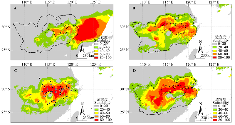
图1 小叶栎现代分布点(黑色点)和MaxEnt模型预测的不同历史时期潜在分布区。实线代表现代适宜区轮廓, 虚线代表现代高度适宜区轮廓。A, 末次盛冰期。B, 全新世中期。C, 现代。D, 2070年。
Fig. 1 Extant occurrence points (black dots) and potential distribution for Quercus chenii during different periods predicted by the MaxEnt model. The solid line and dashed line represent the outline of modern suitable area and highly suitable area, respectively. A, Last Glacial Maximum. B, Mid-Holocene. C, Present. D, In 2070.
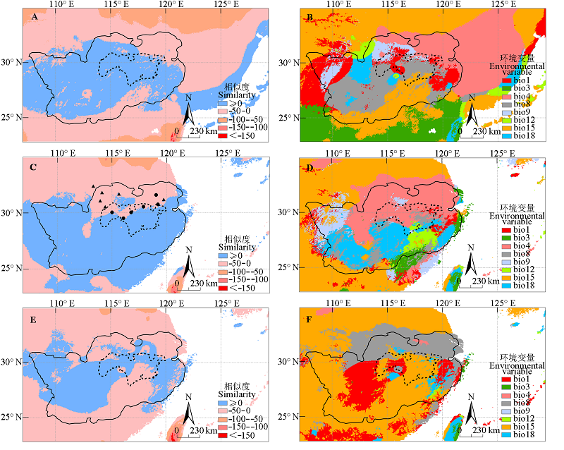
图2 小叶栎不同时期的多元环境相似度面(MESS)和最不相似变量(MoD)。实线代表现代适宜区轮廓, 虚线代表现代高度适宜区轮廓。图2C中, 圆形代表适宜度比现代低的气候异常点, 三角形代表适宜度比现代高的气候异常点。A, 末次盛冰期MESS。B, 末次盛冰期MoD。C, 全新世中期MESS。D, 全新世中期MoD。E, 2070年MESS。F, 2070年MoD。环境变量代码同表1。
Fig. 2 Multivariate environmental similarity surface (MESS) and the most dissimilar (MoD) variable analysis for Quercus chenii during different periods. The solid line and dashed line represent the outline of modern suitable area and highly suitable area, respectively. In Fig. 2C, the circles represent novel climate points with suitability lower than present, and the triangles represent novel climate points with suitability higher than present. A, MESS for the Last Glacial Maximum (LGM). B, MoD for LGM. C, MESS for mid-Holocene. D, MoD for mid-Holocene. E, MESS for 2070. F, MoD for 2070. The codes of environmental variables see Table 1.
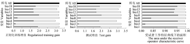
图3 环境变量重要性的Jackknife检验。灰色、白色、黑色条形图分别表示使用单独变量、除该变量外的所有变量和所有变量用于模型预测。变量代码同表1。
Fig. 3 Jackknife test of the importance of variables. Grey, white, and black bars represent running the MaxEnt model with only the variable, without the variable and with all variables, respectively. The codes of variables see Table 1.
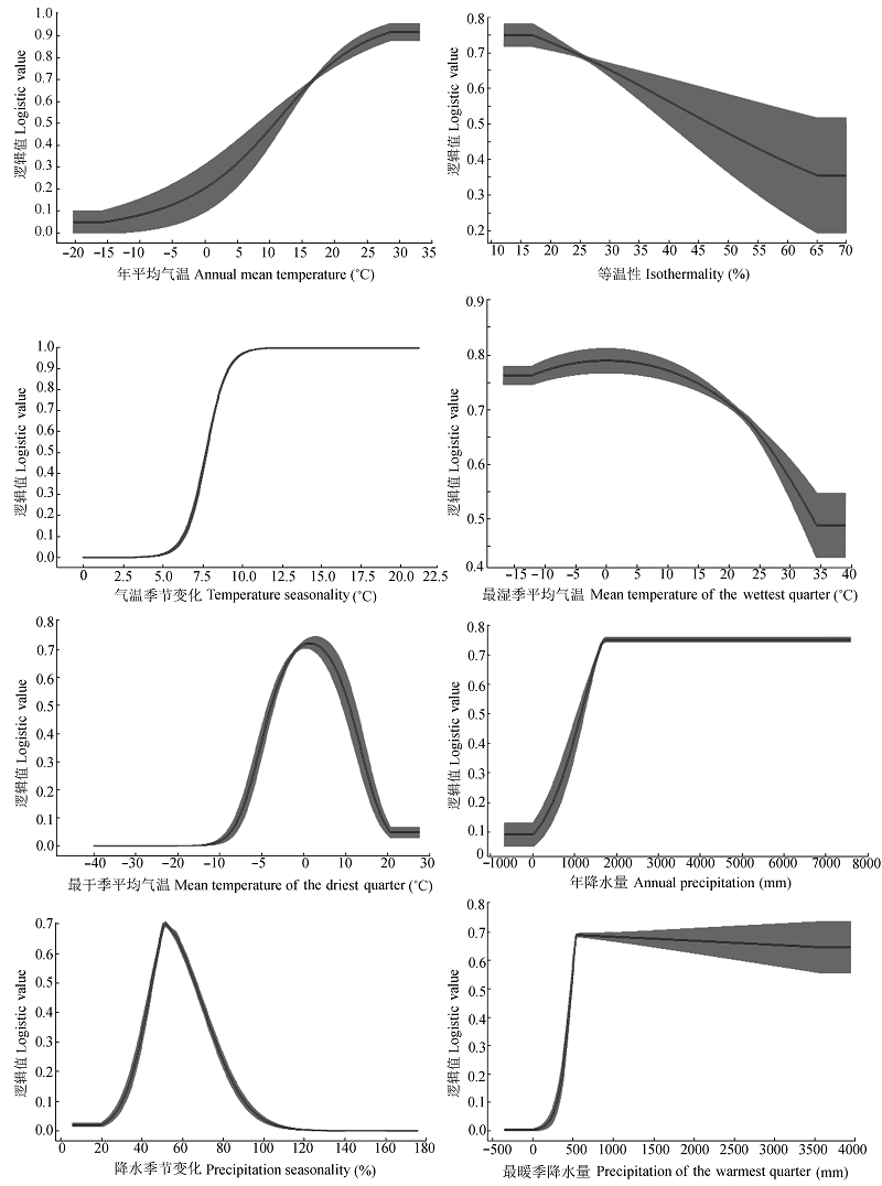
附录II 八个环境变量的边缘响应曲线
Appendix II Marginal response curves for eight environmental variables
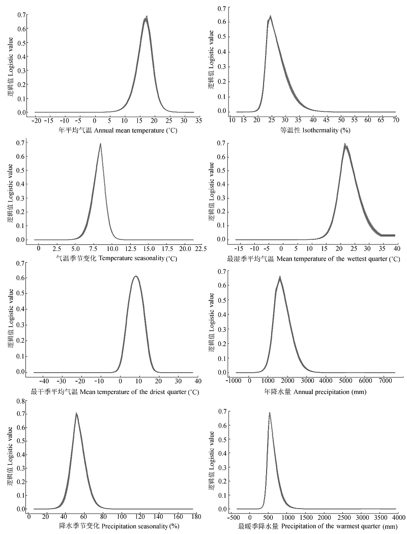
附录III 八个环境变量的单变量响应曲线
Appendix III Single variable response curves for eight environmental variables
| [1] | Bai WN, Zhang DY (2014). Current status and future directions in plant phylogeography.Chinese Bulletin of Life Sciences, 26, 125-136. (in Chinese with English abstract)[白伟宁, 张大勇 (2014). 植物亲缘地理学的研究现状与发展趋势. 生命科学, 26, 125-136.] |
| [2] | Bellard C, Bertelsmeier C, Leadley P, Thuiller W, Courchamp F (2012). Impacts of climate change on the future of biodiversity.Ecology Letters, 15, 365-377. |
| [3] | Chan LM, Brown JL, Yoder AD (2011). Integrating statistical genetic and geospatial methods brings new power to phylogeography.Molecular Phylogenetics and Evolution, 59, 523-537. |
| [4] | Chen DM, Zhang XX, Kang HZ, Sun X, Yin S, Du HM, Yamanaka N, Gapare W, Wu HX, Liu CJ (2012). Phylogeography of Quercus variabilis based on chloroplast DNA sequence in East Asia: Multiple glacial refugia and mainland- migrated island populations. PLOS ONE, 7, e47268. doi:10.1371/journal.pone.0047268. |
| [5] | Chen W, Wang WM, Dai XR (2009). Holocene vegetation history with implications of human impact in the Lake Chaohu area, Anhui Province, East China.Vegetation History & Archaeobotany, 18, 137-146. |
| [6] | Elith J, Graham CH, Anderson RP, Dudík M, Ferrier S, Guisan A, Hijmans RJ, Huettmann F, Leathwick JR, Lehmann A, Li J, Lohmann LG, Loiselle BA, Manion G, Moritz C, Nakamura M, Nakazawa Y, Overton JM, Peterson AT, Phillips SJ, Richardson KS, Scachetti-Pereira R, Schapire RE, Soberón J, Williams S, Wisz MS, Zimmermann NE (2006). Novel methods improve prediction of species’ distributions from occurrence data.Ecography, 29, 129-151. |
| [7] | Elith J, Kearney M, Phillips S (2010). The art of modelling range-shifting species.Methods in Ecology and Evolution, 1, 330-342. |
| [8] | Fang YM, Wang T, Zhang JC (2011). Analysis of quaternary vegetation changes along the Beijing-Hangzhou Grand Canal.Journal of Nanjing Forestry University (Natural Sciences), 35, 109-115. (in Chinese with English abstract)[方炎明, 王挺, 张金池 (2011). 京杭大运河沿线第四纪植被变迁分析. 南京林业大学学报·自然科学版, 35, 109-115.] |
| [9] | Feidas H, Kouam MK, Kantzoura V, Theodoropoulos G (2014). Global geographic distribution of Trichinella species and genotypes. Infection, Genetics and Evolution, 26, 255-266. |
| [10] | Galletti CS, Ridder E, Falconer SE, Fall PL (2013). Maxent modeling of ancient and modern agricultural terraces in the Troodos foothills, Cyprus.Applied Geography, 39, 46-56. |
| [11] | Hewitt GM (2004). Genetic consequences of climatic oscillations in the Quaternary.Philosophical Transactions of the Royal Society B: Biological Sciences, 359, 183-195. |
| [12] | Hijmans RJ, Cameron SE, Parra JL, Jones PG, Jarvis A (2005). Very high resolution interpolated climate surfaces for global land areas.International Journal of Climatology, 25, 1965-1978. |
| [13] | Hou N, Dai Q, Ran JH, Jiao YY, Cheng Y, Zhao C (2014). A corridor design for the giant panda in the Niba Mountain of China.Chinese Journal of Applied and Environmental Biology, 20, 1039-1045. (in Chinese with English abstract)[侯宁, 戴强, 冉江洪, 焦迎迎, 程勇, 赵成 (2014). 相岭山系泥巴山大熊猫生境廊道设计. 应用与环境生物学报, 20, 1039-1045.] |
| [14] | Hu WY, Tu BK (1992). Research on cutting propagation ofQuercus variabilis, Quercus acutissima, Quercus chenii, Castanopsis sclerophylla and Lithocarpus glaber. Hubei Forestry Science and Technology, (2), 35-36. (in Chinese)[胡婉仪, 涂炳坤 (1992). 栓皮栎、麻栎、小叶栎、苦槠、石栎扦插繁殖简报. 湖北林业科技, (2), 35-36.] |
| [15] | Jiang Q, Piperno DR (1999). Environmental and archaeological implications of a late quaternary palynological sequence, Poyang Lake, Southern China.Quaternary Research, 52, 250-258. |
| [16] | Jiang ZH, Zhang X, Wang J (2008). Projection of climate change in China in the 21st century by IPCC-AR4 Models.Geographical Research, 27, 787-799. (in Chinese with English abstract)[江志红, 张霞, 王冀 (2008). IPCC- AR4模式对中国21世纪气候变化的情景预估. 地理研究, 27, 787-799.] |
| [17] | Kumar S, Stohlgren TJ (2009). Maxent modeling for predicting suitable habitat for threatened and endangered tree Canacomyrica monticola in New Caledonia. Journal of Ecology and Natural Environment, 1(4), 94-98. |
| [18] | Li WY (1998). Vegetation and Environment of China During the Quaternary. Science Press, Beijing. (in Chinese)[李文漪 (1998). 中国第四纪植被与环境. 科学出版社, 北京.] |
| [19] | Li Y, Zhang XW, Fang YM (2014). Predicting the impact of global warming on the geographical distribution pattern ofQuercus variabilis in China. Chinese Journal of Applied Ecology, 25, 3381-3389. (in Chinese with English abstract)[李垚, 张兴旺, 方炎明 (2014). 气候变暖对中国栓皮栎地理分布格局影响的预测. 应用生态学报, 25, 3381-3389.] |
| [20] | Liu JL, Wang WM (2004). A discussion on the vegetation types during LGM time in South China.Quaternary Sciences, 24, 213-216. (in Chinese with English abstract)[刘金陵, 王伟铭 (2004). 关于华南地区末次冰盛期植被类型的讨论. 第四纪研究, 24, 213-216.] |
| [21] | Liu MS, Hong BG (1999). The analysis of distribution pattern of Fagaceae in China. Journal of Nanjing Forestry University, 23(5), 18-22. (in Chinese with English abstract)[刘茂松, 洪必恭 (1999). 中国壳斗科的分布格局类型分析. 南京林业大学学报, 23(5), 18-22.] |
| [22] | Ma SM, Nie YB, Geng QL,Wang RX (2014). Impact of climate change on suitable distribution range and spatial pattern in Amygdalu smongolica. Chinese Journal of Plant Ecology, 38, 262-269. (in Chinese with English abstract)[马松梅, 聂迎彬, 耿庆龙, 王荣学 (2014). 气候变化对蒙古扁桃适宜分布范围和空间格局的影响. 植物生态学报, 38, 262-269.] |
| [23] | Matyukhina DS, Miquelle DG, Murzin AA, Pikunov DG, Fomenko PV, Aramilev VV, Litvinov MN, Salkina GP, Seryodkin IV, Nikolaev IG, Kostyria AV, Gaponov VV, Yudin VG, Dunishenko YM, Smirnov EN, Korkishko VG, Marino J (2015). Assessing the influence of environmental parameters on Amur tiger distribution in the Russian far east using a MaxEnt modeling approach.Achievements in the Life Sciences, 8(2), 95-100. |
| [24] | Members of China Quaternary Pollen Data Base (2000). Pollen- based biome reconstruction at Middle Holocene (6ka BP) and Last Glacial Maximum (18 ka BP) in China.Acta Botanica Sinica, 42, 1201-1209. (in Chinese with English abstract)[中国第四纪孢粉数据库小组 (2000). 中国中全新世(6 ka BP)和末次盛冰期(18 ka BP)生物群区的重建. 植物学报, 42, 1201-1209.] |
| [25] | Ni J, Song CY (1998). Relationship between Kira’s indexes and distribution of dominants and companions of subtropical evergreen broadleaved forest in China.Acta Ecologica Sinica, 18, 248-262. (in Chinese with English abstract)[倪健, 宋永昌 (1998). 中国亚热带常绿阔叶林优势种及常见种的分布与Kira指标的关系. 生态学报, 18, 248-262.] |
| [26] | Padalia H, Srivastava V, Kushwaha SPS (2014). Modeling potential invasion range of alien invasive species, Hyptis suaveolens(L.) Poit. in India: Comparison of MaxEnt and GARP. Ecological Informatics, 22, 36-43. |
| [27] | Phillips SJ, Anderson RP, Schapire RE (2006). Maximum entropy modeling of species geographic distributions.Ecological Modelling, 190, 231-259. |
| [28] | Qi CJ (1984). The fundamental pattern of the geographic distribution of vegetation in Hunan Province.Acta Botanica Yunnanica, 6, 403-416. (in Chinese with English abstract)[祁承经(1984). 湖南植被地理分布的基本规律. 云南植物研究, 6, 403-416.] |
| [29] | Shi MM, Michalski SG, Erik W, Chen XY, Durka W (2014). Phylogeography of a widespread Asian subtropical tree: Genetic east-west differentiation and climate envelope modelling suggest multiple glacial refugia.Journal of Biogeography, 41, 1710-1720. |
| [30] | Souza RAD, Marco PD (2014). The use of species distribution models to predict the spatial distribution of deforestation in the western Brazilian Amazon.Ecological Modelling, 291, 250-259. |
| [31] | The Research Group of the Deciduous Oaks (1988). A synoptic summary of the researches on Chinese deciduous oaks.Journal of Beijing Forestry University, (3), 77-83. (in Chinese with English abstract)[北京林业大学落叶栎树研究组 (1988). 中国落叶栎树的综合研究. 北京林业大学学报, (3), 77-83.] |
| [32] | Tian JQ (2007). Differentiated Distribution of Deciduous Quercus spp. and Controlling Climatic Factors in China. Master degree dissertation, Institute of Botany, Chinese Academy of Sciences, Beijing. (in Chinese)[田佳倩 (2007). 落叶栎树在中国的地理替代分布及其气候制约. 硕士学位论文, 中国科学院植物研究所, 北京.] |
| [33] | Tsoar A, Allouche O, Steinitz O, Rotem D, Kadmon R (2007). A comparative evaluation of presence-only methods for modelling species distribution.Diversity and Distributions, 13, 397-405. |
| [34] | Wang LM, Ren XW, Liu YQ (1985). Geographic distribution of deciduous oaks in China.Journal of Beijing Forestry University, (2), 57-69. (in Chinese with English abstract)[王良民, 任宪威, 刘一樵 (1985). 我国落叶栎的地理分布. 北京林业大学学报, (2), 57-69.] |
| [35] | Wang LZ, Lang QL, Xia XH, Sun J, Gao W, Li LF (2013). Research advances in oak germplasm resources.Science of Sericulture, 39, 805-811. (in Chinese with English abstract)[王连珍, 郎庆龙, 夏兴宏, 孙娟, 高伟, 李立峰 (2013). 柞树种质资源研究进展. 蚕业科学, 39, 805-811.] |
| [36] | Wang SM, Xia MJ (1986). Wood structure and some physical- mechanical properties of four Chinese oaks.Journal of Beijing Forestry University, (1), 53-61. (in Chinese with English abstract)[汪师孟, 夏美君 (1986). 中国栎属木材的构造及物理-力学性质(三). 北京林业大学学报, (1), 53-61.] |
| [37] | Wang SW, Luo Y, Zhao ZC, Wen XY, Huang JB (2012). New generation of scenarios of greenhouse gas emission.Advances in Climate Change Research, 8, 305-307. (in Chinese with English abstract)[王绍武, 罗勇, 赵宗慈, 闻新宇, 黄建斌 (2012). 新一代温室气体排放情景. 气候变化研究进展, 8, 305-307.] |
| [38] | Wang YH, Jiang WM, Comes HP, Hu FS, Qiu YX, Fu CX (2015). Molecular phylogeography and ecological niche modelling of a widespread herbaceous climber,Tetrastigma hemsleyanum(Vitaceae): Insights into plio- pleistocene range dynamics of evergreen forest in subtropical China. New Phytologist, 206, 852-867. |
| [39] | Wang YS, Xie BY, Wan FH, Xiao QM, Dai LY (2007). Application of ROC curve analysis in evaluating the performance of alien species’ potential distribution models.Biodiversity Science, 15, 365-372. (in Chinese with English abstract)[王运生, 谢丙炎, 万方浩, 肖启明, 戴良英 (2007). ROC曲线分析在评价入侵物种分布模型中的应用. 生物多样性, 15, 365-372.] |
| [40] | Wu SX, Tian J, Yu XL, Cao FX (2011). A preliminary study of the natural forest vegetationin the limestone regions of Southern Hunan.Journal of Central South University of Forestry & Technology, 31(6), 55-64. (in Chinese with English abstract)[吴诗霞, 田径, 喻勋林, 曹福祥 (2011). 湘南石灰岩地区天然林植被初步研究. 中南林业科技大学学报, 31(6), 55-64.] |
| [41] | Wu ZY (1979). The regionalization of Chinese flora.Acta Botanica Yunnanica, 1(1), 1-20. (in Chinese)[吴征镒 (1979). 论中国植物区系的分区问题. 云南植物研究, 1, 1-20.] |
| [42] | Xu HY, Chang FM, Luo YL, Sun XJ (2009). Palaeoenvironmental changes from pollen record in deep sea core PC-1 from northern Okinawa Trough, East China Sea during the past 24 ka.Chinese Science Bulletin, 54, 3117-3126. (in Chinese)[徐红艳, 常凤鸣, 罗运利, 孙湘君 (2009). 冲绳海槽北部PC-1岩芯24 ka BP以来孢粉记录的古环境信息. 科学通报, 54, 3117-3126.] |
| [43] | Yan WB, Wang Q, Wang C (2015). Evaluation of potential breeding habitat distribution with Maxent model for crested ibis in the Qinling-Bashan region.Chinese Journal of Zoology, 50, 185-193. (in Chinese with English abstract)[颜文博, 王琦, 王超 (2015). 应用Maxent模型分析秦巴地区朱鹮适宜繁殖地的分布. 动物学杂志, 50, 185-193.] |
| [44] | Yang XQ, Kushwaha SPS, Saran S, Xu J, Roy PS (2013). Maxent modeling for predicting the potential distribution of medicinal plant,Justicia adhatoda L. in Lesser Himalayan foothills. Ecological Engineering, 51, 83-87. |
| [45] | Yu HB, Zhang YL, Li SC, Qi W, Hu ZJ (2014). Predicting the dispersal routes of alpine plant Pedicularis longiflora(Orobanchaceae) based on GIS and species distribution models. Chinese Journal of Applied Ecology, 25, 1669-1673. (in Chinese with English abstract)[于海彬, 张镱锂, 李士成, 祁威, 胡忠俊 (2014). 基于GIS和物种分布模型的高山植物长花马先蒿迁移路线模拟. 应用生态学报, 25, 1669-1673.] |
| [46] | Zhang L, Liu SR, Sun PS, Wang TL (2011). Comparative evaluation of multiple models of the effects of climate change on the potentialdistribution ofPinus massoniana. Chinese Journal of Plant Ecology, 35, 1091-1105. (in Chinese with English abstract)[张雷, 刘世荣, 孙鹏森, 王同立 (2011). 气候变化对马尾松潜在分布影响预估的多模型比较. 植物生态学报, 35, 1091-1105.] |
| [47] | Zhang XA, Sui XY, Lü Z, Chen YF (2014). A prediction of the global habitat of two invasive fishes (Pseudorasbora parva and Carassius auratus) from East Asia using Maxent. Biodiversity Science, 22, 182-188. (in Chinese with English abstract)[张熙骜, 隋晓云, 吕植, 陈毅峰 (2014). 基于Maxent的两种入侵性鱼类(麦穗鱼和鲫)的全球适生区预测. 生物多样性, 22, 182-188.] |
| [48] | Zhang XW, Li Y, Liu CY, Xia T, Zhang Q, Fang YM (2015). Phylogeography of the temperate tree species Quercus acutissima in China: Inferences from chloroplast DNA variations. Biochemical Systematics and Ecology, 63, 190-197. |
| [49] | Zheng Z, Huang KY, Deng Y, Cao LL, Yu SH, Suc JP, Berne S, Guichard F (2013). A ~200 ka pollen record from Okinawa Trough: Paleoenvironment reconstruction of glacial- interglacial cycles.Science China: Earth Sciences, 43, 1231-1248. (in Chinese)[郑卓, 黄康有, 邓韫, 曹玲珑, 余少华, Suc JP, Berne S, Guichard F (2013). 冲绳海槽200 ka的孢粉记录及冰期-间冰期旋回古环境重建. 中国科学: 地球科学, 43, 1231-1248.] |
| [1] | 陈以恒 玉素甫江·如素力 阿卜杜热合曼·吾斯曼. 2001-2020年天山新疆段草地植被覆盖度时空变化及驱动因素分析[J]. 植物生态学报, 2024, 48(5): 561-576. |
| [2] | 张计深, 史新杰, 刘宇诺, 吴阳, 彭守璋. 气候变化下中国潜在自然植被生态系统碳储量动态[J]. 植物生态学报, 2024, 48(4): 428-444. |
| [3] | 臧妙涵, 王传宽, 梁逸娴, 刘逸潇, 上官虹玉, 全先奎. 基于纬度移栽的落叶松叶、枝、根生态化学计量特征对气候变暖的响应[J]. 植物生态学报, 2024, 48(4): 469-482. |
| [4] | 梁逸娴, 王传宽, 臧妙涵, 上官虹玉, 刘逸潇, 全先奎. 落叶松径向生长和生物量分配对气候变暖的响应[J]. 植物生态学报, 2024, 48(4): 459-468. |
| [5] | 吴茹茹, 刘美珍, 谷仙, 常馨月, 郭立月, 蒋高明, 祁如意. 气候变化对巨柏适宜生境分布的潜在影响和预测[J]. 植物生态学报, 2024, 48(4): 445-458. |
| [6] | 杨宇萌, 来全, 刘心怡. 气候变化和人类活动对内蒙古植被总初级生产力的定量影响[J]. 植物生态学报, 2024, 48(3): 306-316. |
| [7] | 张启, 程雪寒, 王树芝. 北京西山老龄树记载的森林干扰历史[J]. 植物生态学报, 2024, 48(3): 341-348. |
| [8] | 石荡, 郭传超, 蒋南林, 唐莹莹, 郑凤, 王瑾, 廖康, 刘立强. 新疆野杏天然更新幼株的个体特征及空间分布格局[J]. 植物生态学报, 2023, 47(4): 515-529. |
| [9] | 钟姣, 姜超, 刘世荣, 龙文兴, 孙建新. 海南长臂猿食源植物的潜在物种丰富度分布格局[J]. 植物生态学报, 2023, 47(4): 491-505. |
| [10] | 李晓田, 王铁娟, 韩文娟, 张丽, 张慧, 刘晓婷, 刘雅洁. 东阿拉善珍稀濒危植物绵刺种群结构与点格局分析[J]. 植物生态学报, 2023, 47(4): 506-514. |
| [11] | 任培鑫, 李鹏, 彭长辉, 周晓路, 杨铭霞. 洞庭湖流域植被光合物候的时空变化及其对气候变化的响应[J]. 植物生态学报, 2023, 47(3): 319-330. |
| [12] | 李杰, 郝珉辉, 范春雨, 张春雨, 赵秀海. 东北温带森林树种和功能多样性对生态系统多功能性的影响[J]. 植物生态学报, 2023, 47(11): 1507-1522. |
| [13] | 魏瑶, 马志远, 周佳颖, 张振华. 模拟增温改变青藏高原植物繁殖物候及植株高度[J]. 植物生态学报, 2022, 46(9): 995-1004. |
| [14] | 党宏忠, 张学利, 韩辉, 石长春, 葛玉祥, 马全林, 陈帅, 刘春颖. 樟子松固沙林林水关系研究进展及对营林实践的指导[J]. 植物生态学报, 2022, 46(9): 971-983. |
| [15] | 李肖, PIALUANG Bounthong, 康文辉, 冀晓东, 张海江, 薛治国, 张志强. 近几十年来冀西北山地白桦次生林径向生长对气候变化的响应[J]. 植物生态学报, 2022, 46(8): 919-931. |
| 阅读次数 | ||||||
|
全文 |
|
|||||
|
摘要 |
|
|||||
Copyright © 2026 版权所有 《植物生态学报》编辑部
地址: 北京香山南辛村20号, 邮编: 100093
Tel.: 010-62836134, 62836138; Fax: 010-82599431; E-mail: apes@ibcas.ac.cn, cjpe@ibcas.ac.cn
备案号: 京ICP备16067583号-19
![]()