
Chin J Plant Ecol ›› 2009, Vol. 33 ›› Issue (6): 1101-1111.DOI: 10.3773/j.issn.1005-264x.2009.06.010
• Original article • Previous Articles Next Articles
LIU Jian-Li1,2, WANG Yan-Hui1,*( ), YU Peng-Tao1, CHENG Li-Li3, XIONG Wei1, XU Li-Hong1, Du A-Peng1
Received:2009-05-07
Accepted:2009-08-03
Online:2009-05-07
Published:2021-04-29
Contact:
WANG Yan-Hui
LIU Jian-Li, WANG Yan-Hui, YU Peng-Tao, CHENG Li-Li, XIONG Wei, XU Li-Hong, Du A-Peng. VEGETATION CARRYING CAPACITY BASED ON SOIL WATER ON TYPICAL SLOPES IN THE DIEDIEGOU SMALL WATERSHED OF LIUPAN MOUNTAINS, NORTHWESTERN CHINA[J]. Chin J Plant Ecol, 2009, 33(6): 1101-1111.
| 样地编号 Plot number | 1-1 | 1-2 | 1-3 | 1-4 | 1-5 | 1-6 | 1-7 | 1-8 | 1-9 | ||||||||||
|---|---|---|---|---|---|---|---|---|---|---|---|---|---|---|---|---|---|---|---|
| 海拔 Altitude (m) | 2 035 | 2 041 | 2 058 | 2 086 | 2 105 | 2 120 | 2 136 | 2 165 | 2 188 | ||||||||||
| 坡度 Slope | 12° | 16° | 25° | 33° | 30° | 35° | 34° | 38° | 40° | ||||||||||
| 坡向 Aspect | SE 30o | SE 34o | SE 40o | SE 45o | SE 42o | SE 35o | SE 32o | SE 31o | SE 34o | ||||||||||
| 优势种 Dominant species | 铁杆蒿(Artemisa vestita)+白羊草(Bothriochloa ischaemum)+茭蒿(Artemisia giraldii) | 铁杆蒿(Artemisa vestita)+百里香(Thymus mongolicus) | 虎榛子(Ostryopsis davidiana)+铁杆蒿(Artemisa vestita) | ||||||||||||||||
| 草本层盖度 Herbage coverage (%) | 75 | 80 | 60 | 50 | 70 | 60 | 45 | 35 | 40 | ||||||||||
| 枯落物层盖度 Litter coverage (%) | 70 | 75 | 45 | 25 | 20 | 15 | 0 | 0 | 0 | ||||||||||
| 总覆盖度 Total coverage (%) | 75 | 80 | 60 | 60 | 75 | 65 | 45 | 45 | 50 | ||||||||||
| 生物量 Biomass (g·m-2) | 378.5 | 408.8 | 401.3 | 346.2 | 373.1 | 368.8 | 352.7 | 359.2 | 320.6 | ||||||||||
| 叶面积指数 Leaf area index (LAI) | 0.56 | 0.57 | 0.49 | 0.44 | 0.55 | 0.50 | 0.45 | 0.30 | 0.32 | ||||||||||
| 土层厚度 Soil thickness (cm) | >100 | >100 | 100 | 55 | 70 | 80 | 50 | 35 | 30 | ||||||||||
| 0~40 cm土壤容重 Bulk density of the soil layer 0-40 cm (g·cm-3) | 1.12 | 1.06 | 1.02 | 1.08 | 1.00 | 0.99 | 1.20 | 1.08 | 1.14 | ||||||||||
Table 1 Description of grassland plots (No.1) on a typical sunny slope in small watershed of Diediegou
| 样地编号 Plot number | 1-1 | 1-2 | 1-3 | 1-4 | 1-5 | 1-6 | 1-7 | 1-8 | 1-9 | ||||||||||
|---|---|---|---|---|---|---|---|---|---|---|---|---|---|---|---|---|---|---|---|
| 海拔 Altitude (m) | 2 035 | 2 041 | 2 058 | 2 086 | 2 105 | 2 120 | 2 136 | 2 165 | 2 188 | ||||||||||
| 坡度 Slope | 12° | 16° | 25° | 33° | 30° | 35° | 34° | 38° | 40° | ||||||||||
| 坡向 Aspect | SE 30o | SE 34o | SE 40o | SE 45o | SE 42o | SE 35o | SE 32o | SE 31o | SE 34o | ||||||||||
| 优势种 Dominant species | 铁杆蒿(Artemisa vestita)+白羊草(Bothriochloa ischaemum)+茭蒿(Artemisia giraldii) | 铁杆蒿(Artemisa vestita)+百里香(Thymus mongolicus) | 虎榛子(Ostryopsis davidiana)+铁杆蒿(Artemisa vestita) | ||||||||||||||||
| 草本层盖度 Herbage coverage (%) | 75 | 80 | 60 | 50 | 70 | 60 | 45 | 35 | 40 | ||||||||||
| 枯落物层盖度 Litter coverage (%) | 70 | 75 | 45 | 25 | 20 | 15 | 0 | 0 | 0 | ||||||||||
| 总覆盖度 Total coverage (%) | 75 | 80 | 60 | 60 | 75 | 65 | 45 | 45 | 50 | ||||||||||
| 生物量 Biomass (g·m-2) | 378.5 | 408.8 | 401.3 | 346.2 | 373.1 | 368.8 | 352.7 | 359.2 | 320.6 | ||||||||||
| 叶面积指数 Leaf area index (LAI) | 0.56 | 0.57 | 0.49 | 0.44 | 0.55 | 0.50 | 0.45 | 0.30 | 0.32 | ||||||||||
| 土层厚度 Soil thickness (cm) | >100 | >100 | 100 | 55 | 70 | 80 | 50 | 35 | 30 | ||||||||||
| 0~40 cm土壤容重 Bulk density of the soil layer 0-40 cm (g·cm-3) | 1.12 | 1.06 | 1.02 | 1.08 | 1.00 | 0.99 | 1.20 | 1.08 | 1.14 | ||||||||||
| 样地编号 Plot number | 3-1 | 3-2 | 3-3 | 3-4 | 3-5 | 3-6 | 3-7 | 3-8 | 3-9 |
|---|---|---|---|---|---|---|---|---|---|
| 海拔 Altitude (m) | 1 997 | 2 020 | 2 050 | 2 078 | 2 099 | 2 123 | 2 135 | 2 147 | 2 165 |
| 坡度 Slope | 11o | 12o | 15o | 22o | 24o | 15o | 14o | 14o | 12o |
| 坡向 Aspect | NW 30o | NW 30o | NW 20o | NW 18o | NW 18o | NW 15o | NW 13o | NW 10o | NW 10o |
| 草本层盖度 Herbage coverage (%) | 35 | 30 | 65 | 45 | 35 | 70 | 60 | 60 | 55 |
| 枯落物层盖度 Litter coverage (%) | 1.78 | 1.52 | 3.49 | 2.51 | 4.19 | 4.39 | 2.14 | 0.44 | 0.03 |
| 总覆盖度 Total coverage (%) | 97 | 95 | 97 | 98 | 98 | 80 | 75 | 65 | 60 |
| 林分密度 Forest density (Plant·hm-2) | 1 650 | 1 375 | 1 111 | 1 500 | 1 875 | 625 | 950 | 750 | 400 |
| 树高 Tree height (m) | 8.2 | 9.9 | 9.5 | 8.9 | 9.3 | 5.8 | 4.9 | 4.4 | 2.5 |
| 胸径 DBH(cm) | 8.9 | 9.4 | 9.2 | 9.8 | 8.5 | 6.8 | 5.6 | 5.4 | 2.2 |
| 叶面积指数 LAI | 3.1 | 3.2 | 3.4 | 3.7 | 3.8 | 2.3 | 1.5 | 1.5 | 1.2 |
| 土层厚度 Soil layer thickness (cm) | >200 | >200 | >200 | >200 | >200 | >100 | 100 | 80 | 40 |
| 0~40 cm土壤容重 Bulk density of the soil layer 0-40 cm (g·cm-3) | 1.08 | 1.15 | 1.00 | 0.94 | 0.90 | 1.00 | 0.94 | 1.01 | 0.92 |
Table 2 Description of plantation plots (No. 3) ofLarix principis-rupprechtiion a typical shady slope in small watershed of Diediegou
| 样地编号 Plot number | 3-1 | 3-2 | 3-3 | 3-4 | 3-5 | 3-6 | 3-7 | 3-8 | 3-9 |
|---|---|---|---|---|---|---|---|---|---|
| 海拔 Altitude (m) | 1 997 | 2 020 | 2 050 | 2 078 | 2 099 | 2 123 | 2 135 | 2 147 | 2 165 |
| 坡度 Slope | 11o | 12o | 15o | 22o | 24o | 15o | 14o | 14o | 12o |
| 坡向 Aspect | NW 30o | NW 30o | NW 20o | NW 18o | NW 18o | NW 15o | NW 13o | NW 10o | NW 10o |
| 草本层盖度 Herbage coverage (%) | 35 | 30 | 65 | 45 | 35 | 70 | 60 | 60 | 55 |
| 枯落物层盖度 Litter coverage (%) | 1.78 | 1.52 | 3.49 | 2.51 | 4.19 | 4.39 | 2.14 | 0.44 | 0.03 |
| 总覆盖度 Total coverage (%) | 97 | 95 | 97 | 98 | 98 | 80 | 75 | 65 | 60 |
| 林分密度 Forest density (Plant·hm-2) | 1 650 | 1 375 | 1 111 | 1 500 | 1 875 | 625 | 950 | 750 | 400 |
| 树高 Tree height (m) | 8.2 | 9.9 | 9.5 | 8.9 | 9.3 | 5.8 | 4.9 | 4.4 | 2.5 |
| 胸径 DBH(cm) | 8.9 | 9.4 | 9.2 | 9.8 | 8.5 | 6.8 | 5.6 | 5.4 | 2.2 |
| 叶面积指数 LAI | 3.1 | 3.2 | 3.4 | 3.7 | 3.8 | 2.3 | 1.5 | 1.5 | 1.2 |
| 土层厚度 Soil layer thickness (cm) | >200 | >200 | >200 | >200 | >200 | >100 | 100 | 80 | 40 |
| 0~40 cm土壤容重 Bulk density of the soil layer 0-40 cm (g·cm-3) | 1.08 | 1.15 | 1.00 | 0.94 | 0.90 | 1.00 | 0.94 | 1.01 | 0.92 |
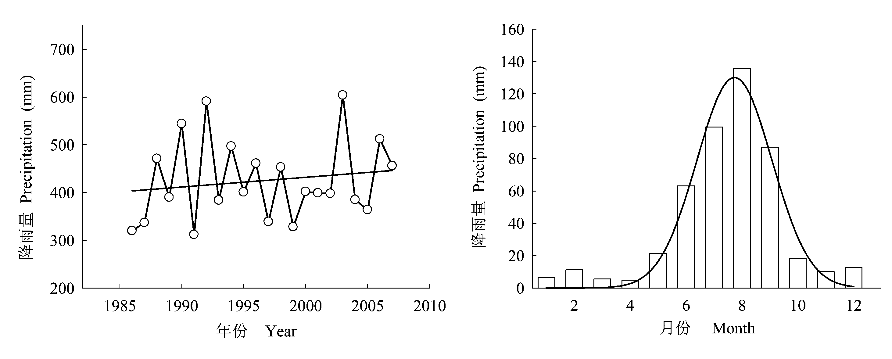
Fig. 1 The annual dynamics and seasonal distribution of precipitation in Diediegou Catchment
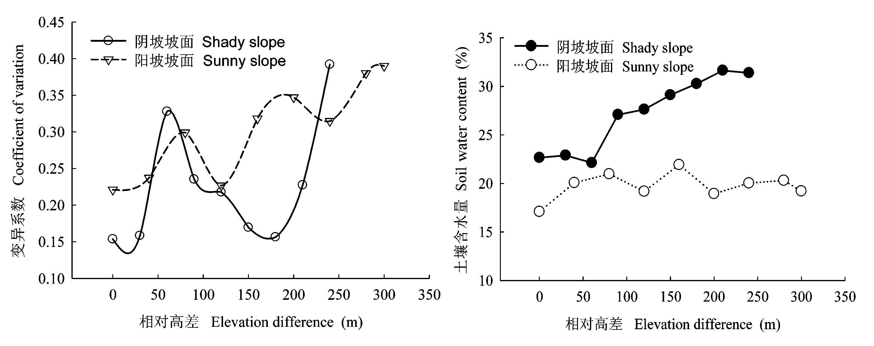
Fig. 2 Variation of soil water in different slope positions with increasing slope position
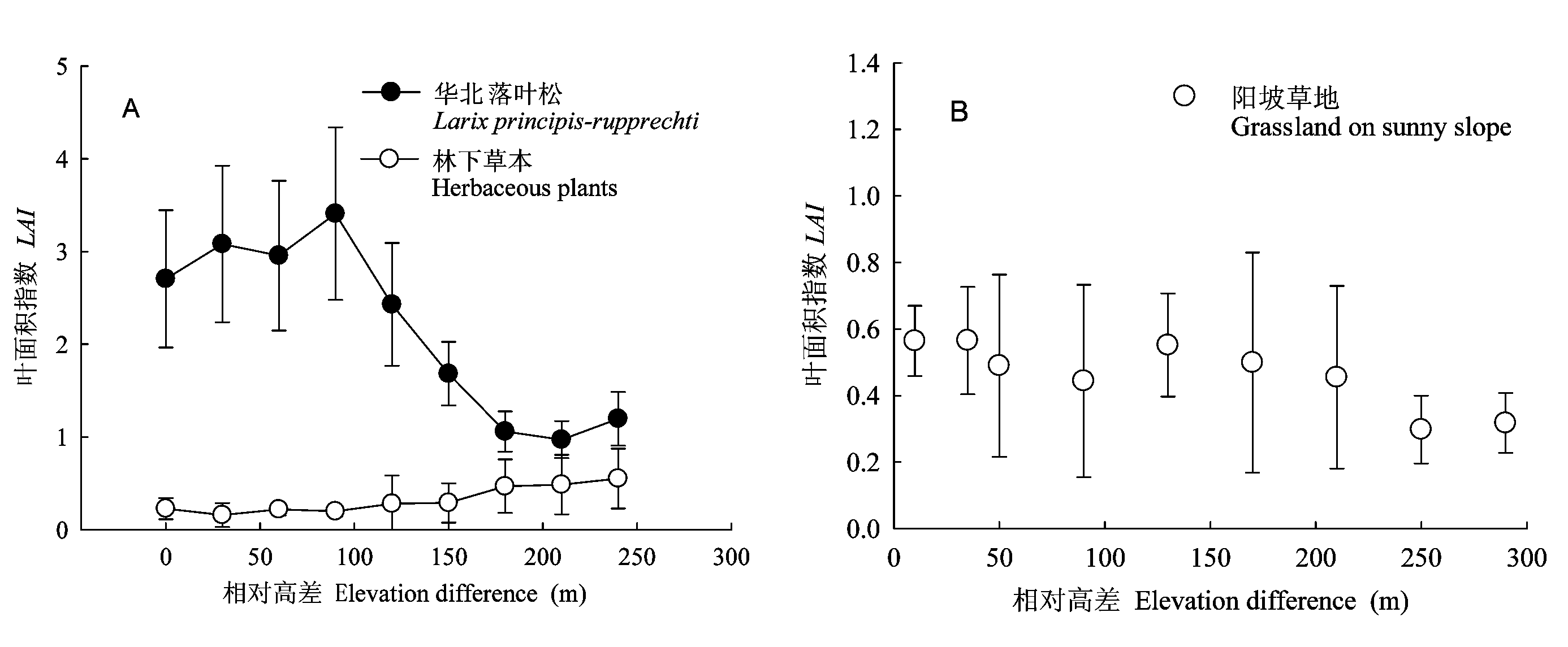
Fig. 3 Variation of leaf area index (LAI) on different slopes (mean±SD)
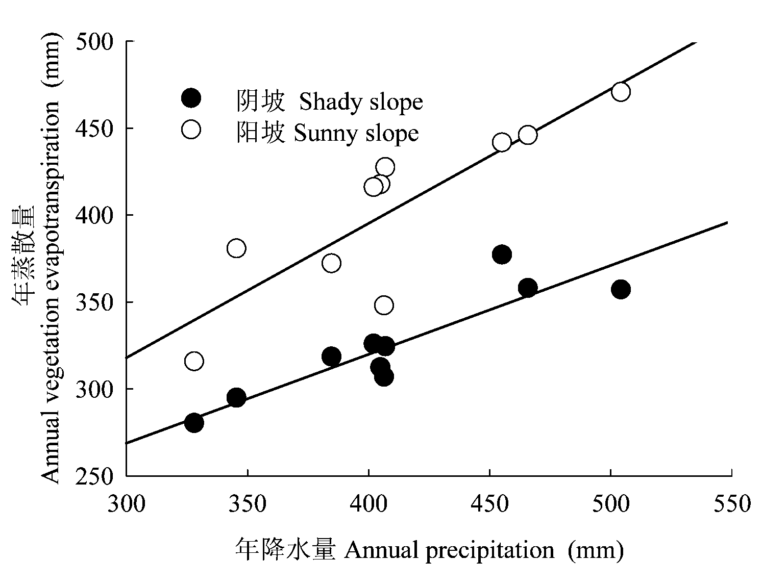
Fig. 4 Relationship between annual precipitation and vegetation evapotranspiration
| 样地 编号 Plot number | 生长季降雨量 Preci- pitation in growing season (mm) | 实测华北落叶松蒸腾 Mea- sured tree trans- piration (mm) | 实测林下蒸散 Measured under-story evapo- transpiration (mm) | 实测林冠截留 Measured canopy interception (mm) | 实测群落蒸散Measured community evapo- transpiration (mm) | 平衡项 Balance item (mm) | 可供蒸散水分 Soil water available for evapo- transpiration (mm) | 依公式(9)计算的可承载LAI Calculated LAIbased on equation (9) | 实测LAI Measured LAI |
|---|---|---|---|---|---|---|---|---|---|
| (1) | (2) | (3) | (4) | (5) | (6) | (7) | (8) | (9) | (10) |
| 3-1 | 465 | 279.41 | 102.70 | 48.09 | 430.20 | 16.26 | 464.46 | 3.26 | 3.09 |
| 3-2 | 465 | 295.11 | 85.67 | 49.96 | 430.74 | 15.72 | 459.92 | 3.18 | 3.21 |
| 3-3 | 465 | 289.77 | 93.11 | 52.94 | 435.82 | 10.64 | 452.47 | 3.06 | 3.40 |
| 3-4 | 465 | 307.67 | 84.03 | 56.65 | 448.35 | -1.89 | 468.57 | 3.33 | 3.64 |
| 3-5 | 465 | 266.85 | 118.63 | 59.30 | 444.78 | 1.68 | 538.98 | 4.83 | 3.81 |
| 3-6 | 465 | 213.48 | 122.13 | 35.19 | 370.80 | 75.66 | 436.58 | 2.81 | 2.26 |
| 3-7 | 465 | 175.81 | 197.55 | 23.34 | 396.70 | 49.76 | 340.23 | 1.69 | 1.50 |
| 3-8 | 465 | 169.53 | 205.05 | 22.57 | 397.15 | 49.32 | 337.66 | 1.67 | 1.45 |
| 3-9 | 465 | 69.07 | 204.62 | 19.14 | 292.83 | 153.64 | 311.36 | 1.45 | 1.23 |
Table 3 Vegetation carrying capacity analysis on different slope positions of Larix principis-rupprechtii slope (LAI)
| 样地 编号 Plot number | 生长季降雨量 Preci- pitation in growing season (mm) | 实测华北落叶松蒸腾 Mea- sured tree trans- piration (mm) | 实测林下蒸散 Measured under-story evapo- transpiration (mm) | 实测林冠截留 Measured canopy interception (mm) | 实测群落蒸散Measured community evapo- transpiration (mm) | 平衡项 Balance item (mm) | 可供蒸散水分 Soil water available for evapo- transpiration (mm) | 依公式(9)计算的可承载LAI Calculated LAIbased on equation (9) | 实测LAI Measured LAI |
|---|---|---|---|---|---|---|---|---|---|
| (1) | (2) | (3) | (4) | (5) | (6) | (7) | (8) | (9) | (10) |
| 3-1 | 465 | 279.41 | 102.70 | 48.09 | 430.20 | 16.26 | 464.46 | 3.26 | 3.09 |
| 3-2 | 465 | 295.11 | 85.67 | 49.96 | 430.74 | 15.72 | 459.92 | 3.18 | 3.21 |
| 3-3 | 465 | 289.77 | 93.11 | 52.94 | 435.82 | 10.64 | 452.47 | 3.06 | 3.40 |
| 3-4 | 465 | 307.67 | 84.03 | 56.65 | 448.35 | -1.89 | 468.57 | 3.33 | 3.64 |
| 3-5 | 465 | 266.85 | 118.63 | 59.30 | 444.78 | 1.68 | 538.98 | 4.83 | 3.81 |
| 3-6 | 465 | 213.48 | 122.13 | 35.19 | 370.80 | 75.66 | 436.58 | 2.81 | 2.26 |
| 3-7 | 465 | 175.81 | 197.55 | 23.34 | 396.70 | 49.76 | 340.23 | 1.69 | 1.50 |
| 3-8 | 465 | 169.53 | 205.05 | 22.57 | 397.15 | 49.32 | 337.66 | 1.67 | 1.45 |
| 3-9 | 465 | 69.07 | 204.62 | 19.14 | 292.83 | 153.64 | 311.36 | 1.45 | 1.23 |
| 样地编号 Plot number | 生长季降雨量 Precipitation in growing season (mm) | 实测群落蒸散量Measured community evapo- transpiration (mm) | 平衡项 Balance item (mm) | 可供蒸散土壤水分 Soil water available for evapotranspiration (mm) | 依公式(10)计算的LAI Calculated LAIbased on equation (10) | 实测LAI Measured LAI |
|---|---|---|---|---|---|---|
| 1-1 | 465 | 291.70 | 173.30 | 338.98 | 0.47 | 0.56 |
| 1-2 | 465 | 292.35 | 172.65 | 339.63 | 0.47 | 0.57 |
| 1-3 | 465 | 253.33 | 211.67 | 300.61 | 0.43 | 0.49 |
| 1-4 | 465 | 229.45 | 235.55 | 276.73 | 0.41 | 0.44 |
| 1-5 | 465 | 285.19 | 179.81 | 332.47 | 0.46 | 0.55 |
| 1-6 | 465 | 258.09 | 206.91 | 305.34 | 0.44 | 0.50 |
| 1-7 | 465 | 235.16 | 229.84 | 282.04 | 0.41 | 0.45 |
| 1-8 | 465 | 246.11 | 218.89 | 289.03 | 0.42 | 0.30 |
| 1-9 | 465 | 230.93 | 234.07 | 230.93 | 0.37 | 0.32 |
Table 4 Vegetation carrying capacity analysis on different slope positions of sunny grassland slope (LAI)
| 样地编号 Plot number | 生长季降雨量 Precipitation in growing season (mm) | 实测群落蒸散量Measured community evapo- transpiration (mm) | 平衡项 Balance item (mm) | 可供蒸散土壤水分 Soil water available for evapotranspiration (mm) | 依公式(10)计算的LAI Calculated LAIbased on equation (10) | 实测LAI Measured LAI |
|---|---|---|---|---|---|---|
| 1-1 | 465 | 291.70 | 173.30 | 338.98 | 0.47 | 0.56 |
| 1-2 | 465 | 292.35 | 172.65 | 339.63 | 0.47 | 0.57 |
| 1-3 | 465 | 253.33 | 211.67 | 300.61 | 0.43 | 0.49 |
| 1-4 | 465 | 229.45 | 235.55 | 276.73 | 0.41 | 0.44 |
| 1-5 | 465 | 285.19 | 179.81 | 332.47 | 0.46 | 0.55 |
| 1-6 | 465 | 258.09 | 206.91 | 305.34 | 0.44 | 0.50 |
| 1-7 | 465 | 235.16 | 229.84 | 282.04 | 0.41 | 0.45 |
| 1-8 | 465 | 246.11 | 218.89 | 289.03 | 0.42 | 0.30 |
| 1-9 | 465 | 230.93 | 234.07 | 230.93 | 0.37 | 0.32 |
| [1] | Bi HX (毕华兴), Li XY (李笑吟), Li J (李俊), Guo MX (郭孟霞), Liu X (刘鑫) (2007). Study on suitable vegetation cover on loess area based on soil water balance. Scientia Silvae Sinicae (林业科学), 43,17-23. (in Chinese with English abstract) |
| [2] | Cao JS (曹军胜), Zhu QK (朱清科), Xue ZD (薛智德) (2008). Vegetation carrying capacity of land and vegetation restration and construction in the Loess Plateau region. Journal of Northwest Forestry University (西北林学院学报), 23,39-43. (in Chinese with English abstract) |
| [3] | Cheng JM (程积民), Wan HE (万惠娥) (2002). Vegetation Planning and Soil and Water Conservation in the Loess Plateau (中国黄土高原植被建设与水土保持). China Forestry Publishing House,Beijing. (in Chinese) |
| [4] | Chen YM (陈云明), Liang YM (梁一民), Cheng JM (程积民) (2002). The zonal character of vegetation construction on Loess Plateau. Acta Phytoecologica Sinica (植物生态学报), 26,339-345. (in Chinese with English abstract) |
| [5] | David P (1999). Carrying capacity reconsidered. Population and Environment, 21,5-26. |
| [6] | Federer CA (1995). BROOK90: A Simulation Model for Evaporation, Soil Water, and Streamflow, Version 3.1. Computer freeware and documentation. USDA Forest Service, PO Box 640, Durham NH, 03824. |
| [7] | Fu BJ (傅伯杰), Yang ZJ (杨志坚), Wang YL (王仰麟), Zhang PW (张平文) (2001). A mathematical model for space distribution of soil moisture in Loess Hilly region. Science in China (Series D)(中国科学D辑), 33,185-191. (in Chinese) |
| [8] | Gao Q (高琼), Dong XJ (董学军), Liang N (梁宁) (1996). A study on the optimal vegetation coverage for sandy grassland in northern China based on soil water budget. Acta Ecologica Sinica (生态学报), 16,33-39. (in Chinese with English abstract) |
| [9] | Guo ZS (郭忠升), Shao MA (邵明安) (2003a). Precipitation, soil water and soil water carrying capacity of vegetation. Journal of Natural Resources (自然资源学报), 18,522-528. (in Chinese with English abstract) |
| [10] | Guo ZS (郭忠升), Shao MA (邵明安) (2003b). Soil water carrying capacity of vegetation and soil desiccation in artificial forestry and grassland in semi-arid regions of the Loess Plateau. Acta Ecologica Sinica (生态学报), 23,1640-1647. (in Chinese with English abstract) |
| [11] | He FH (何福红), Huang MB (黄明斌), Dang TH (党廷辉) (2003). Distribution characteristic of dried soil layer in Wangdonggou watershed in gully region of the Loess Plateau. Journal of Natural Resources (自然资源学报), 18,30-36. (in Chinese with English abstract) |
| [12] | Liu JL (刘建立) (2008). Study on the Soil Water Vegetation Carrying Capacity on Slopes in the Small Watershed of Diediegou of Liupan Mountains (六盘山叠叠沟小流域坡面土壤水分植被承载力研究). PhD dissertation, Chinese Academy of Forestry. (in Chinese) |
| [13] | Pan CZ (潘成忠), Shangguan ZP (上官周平) (2004). Spatial variability of soil moisture, nutrients, and productivity on slopeland in loessial semiarid region. Chinese Journal of Applied Ecology (应用生态学报), 2061-2066. (in Chinese with English abstract) |
| [14] | Radersma S, Ong CK, Coe R (2006). Water use of tree lines: importance of leaf area and micrometeorology in sub-humid Kenya. Agroforestry Systems, 66,179-189. |
| [15] | Wang BR (王斌瑞), Wang BT (王百田) (1996). Technique for Runoff Forestry in the Loess Plateau (黄土高原径流林业技术研究). China Forestry Publishing House,Beijing. (in Chinese) |
| [16] | Wang L, Shao MA, Hou QC (2000). Status of dried soil layer in the Yan’an experimental area. Bulletin of Soil and Water Conservation, 20,35-37. |
| [17] | Wang J (王俭), Sun TY (孙铁珩), Li PJ (李培军) (2005). Research progress on environmental carrying capacity. Chinese Journal of Applied Ecology (应用生态学报), 16,768-772. (in Chinese with English abstract) |
| [18] | Wang YH (王彦辉), Jin M (金旻), Yu PT (于澎涛) (2003). The environment problems related with forest/ vegetation and water resources in China and future research requirements. Forest Research (林业科学研究), 16,739-747. (in Chinese with English abstract) |
| [19] | Wang YH (王彦辉), Xiong W (熊伟), Yu PT (于澎涛), Shen ZX (沈振西), Guo MC (郭明春), Guan W (管伟), Ma CM (马长明), Ye B (叶兵), Guo H (郭浩) (2006). Study on the evapotranspiration of forest and vegetation in dryland. Science of Soil and Water Conservation (中国水土保持科学), 4(4),19-25. (in Chinese with English abstract) |
| [20] | Wang YH, Yu PT, Xiong W (2008). Water yield reduction after afforestation and related processes in the semiarid Liupan Mountains, Northwest China. Journal of the American Water Resources Association, 44,1086-1097. |
| [21] | Xia YQ, Shao MA (2008). Soil water carrying capacity for vegetation: a hydrologic and biogeochemical process model solution. Ecological Modelling, 214,112-124. |
| [22] | Xiong W (熊伟) (2003). Studies on Water Consumption Characteristics of Main Plantation Tree Species in the Northern of Liupanshan Mountain (六盘山北侧主要造林树种水分消耗特征研究). PhD dissertation, Chinese Academy of Forestry. (in Chinese) |
| [23] | Yang WX (杨维西) (1996). The preliminary discussion on soil desiccation of artificial vegetation in the northern regions of China. Scientia Silvae Sinicae (林业科学), 32,78-85. (in Chinese with English abstract) |
| [24] | Yang WZ (杨文治), Shao MA (邵明安) (2000). Research of Soil Water in the Loess Plateau (黄土高原土壤水分研究). Science Press, Beijing. (in Chinese) |
| [25] | Zhang WH (张文辉), Liu GB (刘国彬) (2009). Vegatation rehabilitation and building of Loess Plateau.Soil and Water Conservation in China(中国水土保持), 1,24-27. (in Chinese) |
| [26] | Zhu JZ (朱金兆), Wei TX (魏天兴), Zhang XP (张学培) (2002). Arrangement of protective forest system in gulled-hilly loess area based on water balance. Journal of Beijing Forestry University (北京林业大学学报), 24,4-13. (in Chinese with English abstract) |
| [1] | Kangwei Jiang Qing-Qing QINGZHANG Wang Yafei Li Hong Ding Yu Yang Yongqiang Tuerxunnayi Reyimu. Characteristics of plant functional groups and the relationships with soil environmental factors in the middle part of the northern slope of Tianshan Mountain under different grazing intensities [J]. Chin J Plant Ecol, 2024, 48(预发表): 0-0. |
| [2] | CHEN Xue-Ping, ZHAO Xue-Yong, ZHANG Jing, WANG Rui-Xiong, LU Jian-Nan. Variation of NDVI spatio-temporal characteristics and its driving factors based on geodetector model in Horqin Sandy Land, China [J]. Chin J Plant Ecol, 2023, 47(8): 1082-1093. |
| [3] | SHEN Jian, HE Zong-Ming, DONG Qiang, GAO Shi-Lei, LIN Yu. Effects of mild fire on soil respiration rate and abiotic factors in coastal sandy plantation [J]. Chin J Plant Ecol, 2023, 47(7): 1032-1042. |
| [4] | LUO Na-Na, SHENG Mao-Yin, WANG Lin-Jiao, SHI Qing-Long, HE Yu. Effects of long-term vegetation restoration on soil active organic carbon fractions content and enzyme activities in karst rocky desertification ecosystem of southwest China [J]. Chin J Plant Ecol, 2023, 47(6): 867-881. |
| [5] | YANG Li-Lin, XING Wan-Qiu, WANG Wei-Guang, CAO Ming-Zhu. Variation of sap flow rate of Cunninghamia lanceolata and its response to environmental factors in the source area of Xinʼanjiang River [J]. Chin J Plant Ecol, 2023, 47(4): 571-583. |
| [6] | LI Xue, DONG Jie, HAN Guang-Xuan, ZHANG Qi-Qi, XIE Bao-Hua, LI Pei-Guang, ZHAO Ming-Liang, CHEN Ke-Long, SONG Wei-Min. Response of soil CO2 and CH4 emissions to changes in moisture and salinity at a typical coastal salt marsh of Yellow River Delta [J]. Chin J Plant Ecol, 2023, 47(3): 434-446. |
| [7] | HE Lu-Lu, ZHANG Xuan, ZHANG Yu-Wen, WANG Xiao-Xia, LIU Ya-Dong, LIU Yan, FAN Zi-Ying, HE Yuan-Yang, XI Ben-Ye, DUAN Jie. Crown characteristics and its relationship with tree growth on different slope aspects for Larix olgensis var. changbaiensis plantation in eastern Liaoning mountainous area, China [J]. Chin J Plant Ecol, 2023, 47(11): 1523-1539. |
| [8] | ZANG Yong-Xin, MA Jian-Ying, ZHOU Xiao-Bing, TAO Ye, YIN Ben-Feng, Shayaguli JIGEER, ZHANG Yuan-Ming. Effects of extreme drought and extreme precipitation on aboveground productivity of ephemeral plants across different slope positions along sand dunes [J]. Chin J Plant Ecol, 2022, 46(12): 1537-1550. |
| [9] | CUI Guang-Shuai, LUO Tian-Xiang, LIANG Er-Yuan, ZHANG Lin. Advances in the study of shrubland facilitation on herbs in arid and semi-arid regions [J]. Chin J Plant Ecol, 2022, 46(11): 1321-1333. |
| [10] | DENG Meng-Da, YOU Jian-Rong, LI Jia-Xiang, LI Xiong, YANG Jing, DENG Chuang-Fa, LIU Ang, LIU Wen-Jian, DING Cong, XIE Yong, ZHOU Guo-Hui, YU Xun-Lin. Community characteristics of main vegetation types in the ecological “green-core” area of Changzhutan urban cluster [J]. Chin J Plant Ecol, 2020, 44(12): 1296-1304. |
| [11] | ZHANG Wen-Qiang, LUO Ge-Ping, ZHENG Hong-Wei, WANG Hao, HAMDI Rafiq, HE Hui-Li, CAI Peng, CHEN Chun-Bo. Analysis of vegetation index changes and driving forces in inland arid areas based on random forest model: a case study of the middle part of northern slope of the north Tianshan Mountains [J]. Chin J Plant Ecol, 2020, 44(11): 1113-1126. |
| [12] | CHEN Chan, ZHANG Shi-Ji, LI Lei-Da, LIU Zhao-Dan, CHEN Jin-Lei, GU Xiang, WANG Liu-Fang, FANG Xi. Carbon, nitrogen and phosphorus stoichiometry in leaf, litter and soil at different vegetation restoration stages in the mid-subtropical region of China [J]. Chin J Plant Ecol, 2019, 43(8): 658-671. |
| [13] | WANG Ming-Ming,LIU Xin-Ping,HE Yu-Hui,ZHANG Tong-Hui,WEI Jing,Chelmge ,SUN Shan-Shan. How enclosure influences restored plant community changes of different initial types in Horqin Sandy Land [J]. Chin J Plant Ecol, 2019, 43(8): 672-684. |
| [14] | LI Quan-Di, LIU Min-Xia, XIA Su-Juan, NAN Xiao-Ning, JIANG Xiao-Xuan. Changes in species-abundance relationships of plant communities with slopes in alpine meadows of Gannan, China [J]. Chin J Plant Ecol, 2019, 43(5): 418-426. |
| [15] | LI Jian-Jun, LIU Lian, CHEN Di-Ma, XU Feng-Wei, CHENG Jun-Hui, BAI Yong-Fei. Effects of collar size and buried depth on the measurement of soil respiration in a typical steppe [J]. Chin J Plant Ecol, 2019, 43(2): 152-164. |
| Viewed | ||||||
|
Full text |
|
|||||
|
Abstract |
|
|||||
Copyright © 2026 Chinese Journal of Plant Ecology
Tel: 010-62836134, 62836138, E-mail: apes@ibcas.ac.cn, cjpe@ibcas.ac.cn
![]()