
植物生态学报 ›› 2021, Vol. 45 ›› Issue (5): 487-495.DOI: 10.17521/cjpe.2020.0076 cstr: 32100.14.cjpe.2020.0076
所属专题: 生态遥感及应用; 青藏高原植物生态学:遥感生态学
陈哲1, 汪浩2,*( ), 王金洲1, 石慧瑾1, 刘慧颖3, 贺金生1,2
收稿日期:2020-03-19
接受日期:2020-05-28
出版日期:2021-05-20
发布日期:2020-06-12
作者简介:*(wanghao@lzu.edu.cn)基金资助:
CHEN Zhe1, WANG Hao2,*(), WANG Jin-Zhou1, SHI Hui-Jin1, LIU Hui-Ying3, HE Jin-Sheng1,2
Received:2020-03-19
Accepted:2020-05-28
Online:2021-05-20
Published:2020-06-12
Supported by:摘要:
准确评估地上生物量对优化草地资源管理和理解草地碳、水和能量平衡具有重要意义。该文通过近地遥感归一化植被指数(NDVI)构建最优经验模型, 对青藏高原高寒草地地上生物量进行估算。该文利用2018-2019年5-9月野外实测的地上生物量和植物冠层光谱仪(RapidSCAN)测定的NDVIRS数据, 构建了生长季不同时期地上生物量的估算模型; 并结合2018年NetCam物候相机测定的NDVICam时间序列数据, 实现地上生物量季节动态的模拟。主要结果: (1) NDVICam、NDVIRS与地上生物量具有相似的单峰型季节变化格局, 但NDVI峰值出现的时间(7月)较地上生物量(8月)更早; (2)基于NDVI的生物量估算最优经验模型在5、7和9月是幂函数, 在6和8月是二次多项式, 估算精度为0.29-0.77; (3)基于NDVICam时间序列数据, 生长季不同时期建模(R2 = 0.91)较单一时期(9月)建模(R2 = 0.49)对地上生物量季节动态的估算更为准确。这些结果表明, 近地遥感是估算高寒草地植物地上生物量的有效手段, 开展季节性植物生长调查将有助于准确评估草地资源。
陈哲, 汪浩, 王金洲, 石慧瑾, 刘慧颖, 贺金生. 基于物候相机归一化植被指数估算高寒草地植物地上生物量的季节动态. 植物生态学报, 2021, 45(5): 487-495. DOI: 10.17521/cjpe.2020.0076
CHEN Zhe, WANG Hao, WANG Jin-Zhou, SHI Hui-Jin, LIU Hui-Ying, HE Jin-Sheng. Estimation on seasonal dynamics of alpine grassland aboveground biomass using phenology camera-derived NDVI. Chinese Journal of Plant Ecology, 2021, 45(5): 487-495. DOI: 10.17521/cjpe.2020.0076
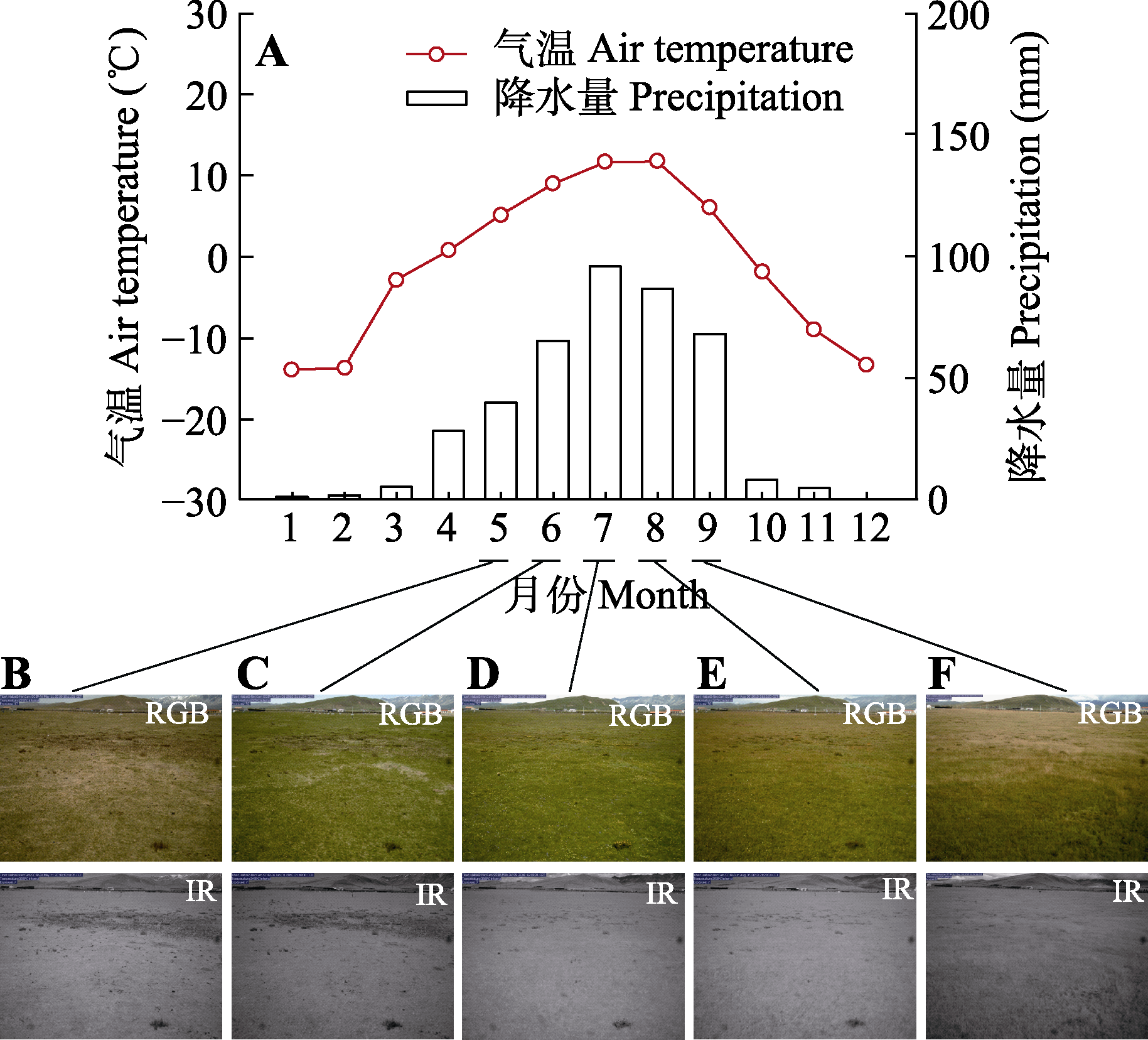
图1 海北站气温和降水的季节动态以及生长季各时期高寒草地植被生长状况。A, 2018和2019年的月平均气温和月降水量。B-F, 5-9月高寒草地植被生长的物候相机图像。NIR, 近红外图像; RGB, 红绿蓝图像。
Fig. 1 Seasonal dynamics of air temperature and precipitation, and the alpine grassland vegetation growth in different phases of the growing season at Haibei Station. A, Mean monthly air temperature and precipitation in 2018 and 2019. B-F, Pictures of plant growth from May to September as photographed by phenology camera. NIR, near-infrared images; RGB, red-green-blue images.
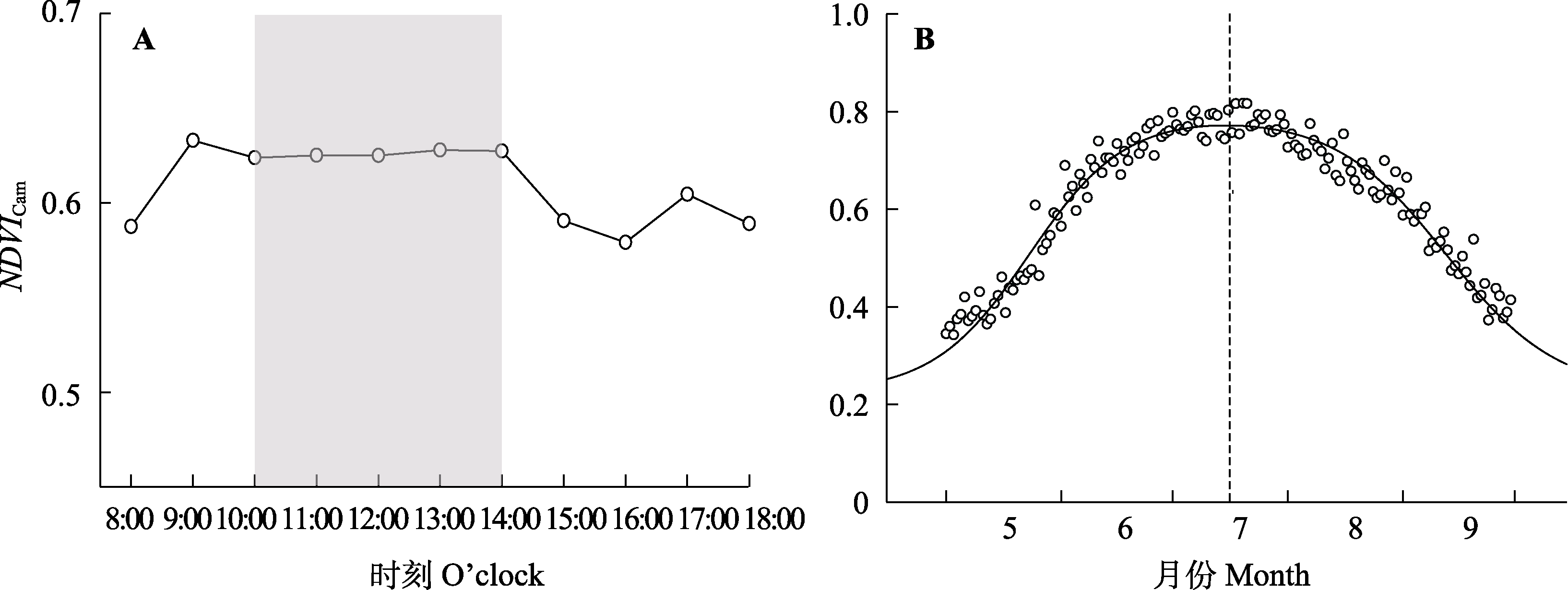
图2 海北站2018年5-9月物候相机归一化植被指数(NDVICam)的平均日动态(A)和季节动态(B)。A中阴影部分表示10:00-14:00物候相机的NDVI最为稳定。
Fig. 2 Diurnal (A) and seasonal patterns (B) of normalized difference of vegetation index measured by NetCam (NDVICam) from May to September in 2018 at Haibei Station. The shaded part in A indicates that the NDVI of the phenology camera from 10:00-14:00 is the most stable.
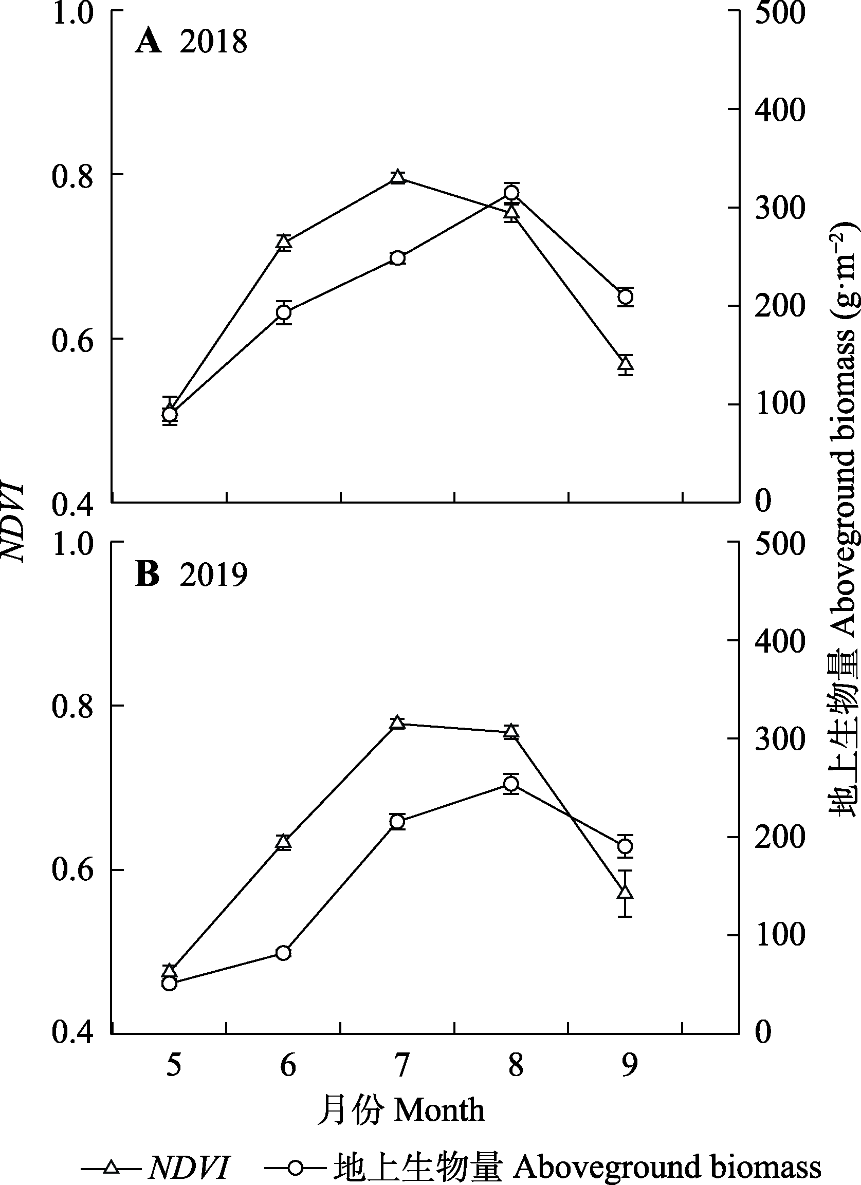
图3 海北站2018 (A)和2019年(B)生长季高寒草地手持式植物冠层光谱仪测量的归一化植被指数(NDVI)与地上生物量的变化(平均值±标准误)。
Fig. 3 Dynamics of the normalized difference of vegetation index (NDVI) measured by RapidSCAN and aboveground biomass (mean ± SE) of alpine grassland in the growing seasons of 2018 (A) and 2019 (B) at Haibei Station.
| 月份 Month | 样本数 No. of samples | r | p |
|---|---|---|---|
| 5 | 56 | 0.80 | <0.001 |
| 6 | 34 | 0.88 | <0.001 |
| 7 | 64 | 0.67 | <0.001 |
| 8 | 51 | 0.31 | 0.03 |
| 9 | 63 | 0.78 | <0.001 |
表1 生长季不同月份高寒草地手持式植物冠层光谱仪测量的归一化植被指数与地上生物量之间的相关性
Table 1 Pearson correlation coefficients between normalized difference of vegetation index measured by RapidSCAN and aboveground biomass of alpine grassland in different months of the growing season
| 月份 Month | 样本数 No. of samples | r | p |
|---|---|---|---|
| 5 | 56 | 0.80 | <0.001 |
| 6 | 34 | 0.88 | <0.001 |
| 7 | 64 | 0.67 | <0.001 |
| 8 | 51 | 0.31 | 0.03 |
| 9 | 63 | 0.78 | <0.001 |
| 月份 Month | 模型 Model | 回归方程 Regression equation | R2 | RMSE | RMSEr (%) |
|---|---|---|---|---|---|
| 5月 May (n = 56) | 线性 Linear | y = 397.3x - 130.6 | 0.67 | 13.62 | 25.38 |
| 对数 Logarithm | y = 186.0ln(x) + 198.3 | 0.65 | 14.32 | 26.68 | |
| 指数 Exponent | y = 2.0e6.9x | 0.65 | 13.03 | 24.28 | |
| 乘幂 Power | y = 615.1x3.3 | 0.67 | 12.45 | 23.19 | |
| 多项式 Quadratic | y = 491.7x2 - 83.7x - 14.7 | 0.65 | 12.88 | 24.00 | |
| 6月 June (n = 34) | 线性 Linear | y = 1080.5x - 595.7 | 0.75 | 24.99 | 21.12 |
| 对数 Logarithm | y = 730.4ln(x) + 423.1 | 0.73 | 26.82 | 22.66 | |
| 指数 Exponent | y = 0.7e7.7x | 0.74 | 22.25 | 18.80 | |
| 乘幂 Power | y = 939.7x5.2 | 0.74 | 21.95 | 18.55 | |
| 多项式 Quadratic | y = 3363.7x2 - 3537.5x + 979.2 | 0.77 | 20.04 | 16.94 | |
| 7月 July (n = 64) | 线性 Linear | y = 952.0x - 508.5 | 0.72 | 39.94 | 18.54 |
| 对数 Logarithm | y = 730.2ln(x) + 416.7 | 0.71 | 40.35 | 18.73 | |
| 指数 Exponent | y = 8.4e4.2x | 0.73 | 38.00 | 17.64 | |
| 乘幂 Power | y = 517.6x3.3 | 0.73 | 37.65 | 17.48 | |
| 多项式 Quadratic | y = 1422.3x2 - 1248.1x + 339.51 | 0.72 | 38.95 | 18.08 | |
| 8月 August (n = 51) | 线性 Linear | y = 532.0x - 105.1 | 0.18 | 38.72 | 13.43 |
| 对数 Logarithm | y = 375.4ln(x) + 403.0 | 0.16 | 39.01 | 13.53 | |
| 指数 Exponent | y = 81.9e1.7x | 0.16 | 34.73 | 12.04 | |
| 乘幂 Power | y = 402.3x1.2 | 0.14 | 35.28 | 12.23 | |
| 多项式 Quadratic | y = 5968.0x2 - 8287.3x + 3134.3 | 0.29 | 31.70 | 10.99 | |
| 9月 September (n = 63) | 线性 Linear | y = 507.3x - 85.5 | 0.61 | 38.17 | 19.30 |
| 对数 Logarithm | y = 292.5ln(x) + 371.7 | 0.61 | 38.18 | 19.31 | |
| 指数 Exponent | y = 48.0e2.5x | 0.62 | 37.92 | 19.18 | |
| 乘幂 Power | y = 448.2x1.4 | 0.63 | 37.68 | 19.06 | |
| 多项式 Quadratic | y = -48.0x2 + 563.9x - 101.8 | 0.61 | 37.87 | 19.15 |
表2 2018和2019年生长季高寒草地手持式植物冠层光谱仪测量的归一化植被指数(NDVIRS)(x)与地上生物量(y)之间的经验模型构建
Table 2 Fitted regression equations between normalized difference of vegetation index measured by RapidSCAN (NDVIRS)(x) and aboveground biomass (y) of alpine grassland across the growing seasons of 2018 and 2019
| 月份 Month | 模型 Model | 回归方程 Regression equation | R2 | RMSE | RMSEr (%) |
|---|---|---|---|---|---|
| 5月 May (n = 56) | 线性 Linear | y = 397.3x - 130.6 | 0.67 | 13.62 | 25.38 |
| 对数 Logarithm | y = 186.0ln(x) + 198.3 | 0.65 | 14.32 | 26.68 | |
| 指数 Exponent | y = 2.0e6.9x | 0.65 | 13.03 | 24.28 | |
| 乘幂 Power | y = 615.1x3.3 | 0.67 | 12.45 | 23.19 | |
| 多项式 Quadratic | y = 491.7x2 - 83.7x - 14.7 | 0.65 | 12.88 | 24.00 | |
| 6月 June (n = 34) | 线性 Linear | y = 1080.5x - 595.7 | 0.75 | 24.99 | 21.12 |
| 对数 Logarithm | y = 730.4ln(x) + 423.1 | 0.73 | 26.82 | 22.66 | |
| 指数 Exponent | y = 0.7e7.7x | 0.74 | 22.25 | 18.80 | |
| 乘幂 Power | y = 939.7x5.2 | 0.74 | 21.95 | 18.55 | |
| 多项式 Quadratic | y = 3363.7x2 - 3537.5x + 979.2 | 0.77 | 20.04 | 16.94 | |
| 7月 July (n = 64) | 线性 Linear | y = 952.0x - 508.5 | 0.72 | 39.94 | 18.54 |
| 对数 Logarithm | y = 730.2ln(x) + 416.7 | 0.71 | 40.35 | 18.73 | |
| 指数 Exponent | y = 8.4e4.2x | 0.73 | 38.00 | 17.64 | |
| 乘幂 Power | y = 517.6x3.3 | 0.73 | 37.65 | 17.48 | |
| 多项式 Quadratic | y = 1422.3x2 - 1248.1x + 339.51 | 0.72 | 38.95 | 18.08 | |
| 8月 August (n = 51) | 线性 Linear | y = 532.0x - 105.1 | 0.18 | 38.72 | 13.43 |
| 对数 Logarithm | y = 375.4ln(x) + 403.0 | 0.16 | 39.01 | 13.53 | |
| 指数 Exponent | y = 81.9e1.7x | 0.16 | 34.73 | 12.04 | |
| 乘幂 Power | y = 402.3x1.2 | 0.14 | 35.28 | 12.23 | |
| 多项式 Quadratic | y = 5968.0x2 - 8287.3x + 3134.3 | 0.29 | 31.70 | 10.99 | |
| 9月 September (n = 63) | 线性 Linear | y = 507.3x - 85.5 | 0.61 | 38.17 | 19.30 |
| 对数 Logarithm | y = 292.5ln(x) + 371.7 | 0.61 | 38.18 | 19.31 | |
| 指数 Exponent | y = 48.0e2.5x | 0.62 | 37.92 | 19.18 | |
| 乘幂 Power | y = 448.2x1.4 | 0.63 | 37.68 | 19.06 | |
| 多项式 Quadratic | y = -48.0x2 + 563.9x - 101.8 | 0.61 | 37.87 | 19.15 |
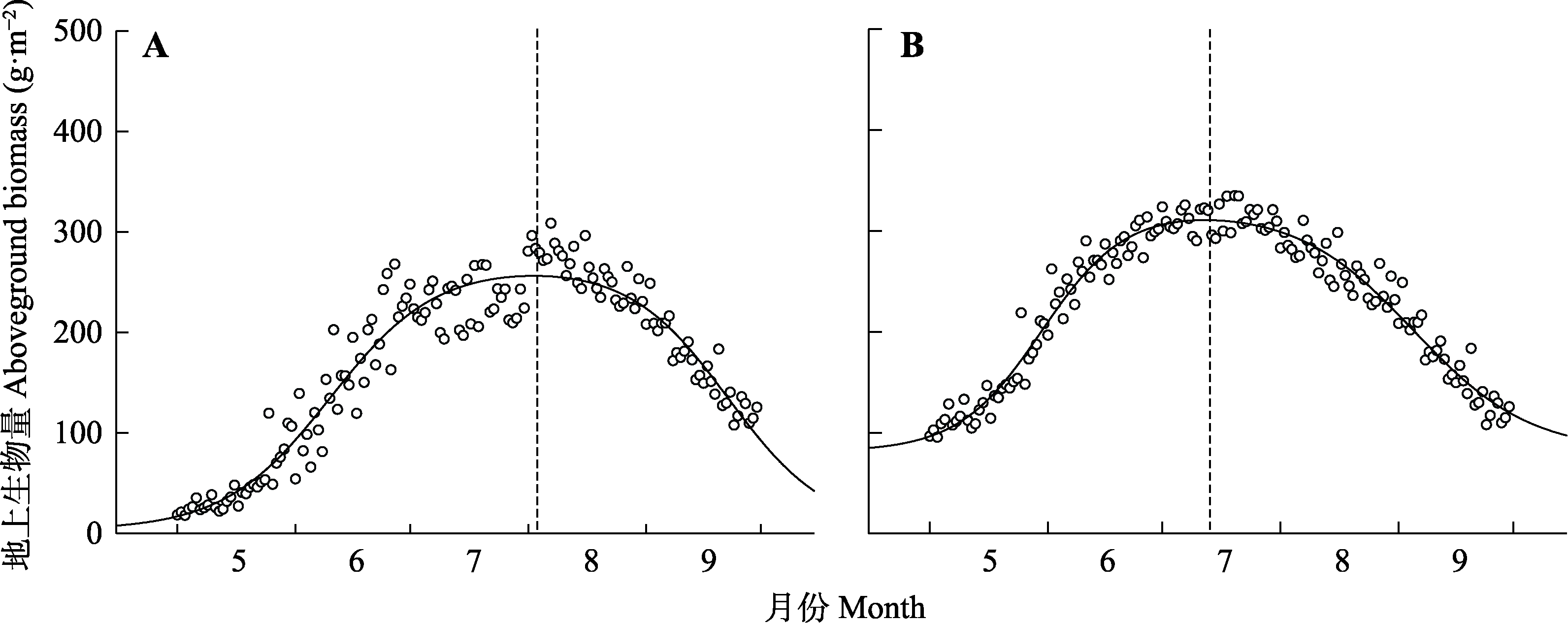
图4 基于物候相机归一化植被指数时间序列数据, 利用生长季不同阶段建模(A)和单一时期(9月)建模(B)分别估算2018年高寒草地生物量的季节动态。
Fig. 4 Seasonal dynamics of alpine grassland biomass estimated by the normalized difference of vegetation index measured by NetCam time series and the models in different phases of growing season (A) and at a single time (September)(B) in 2018.
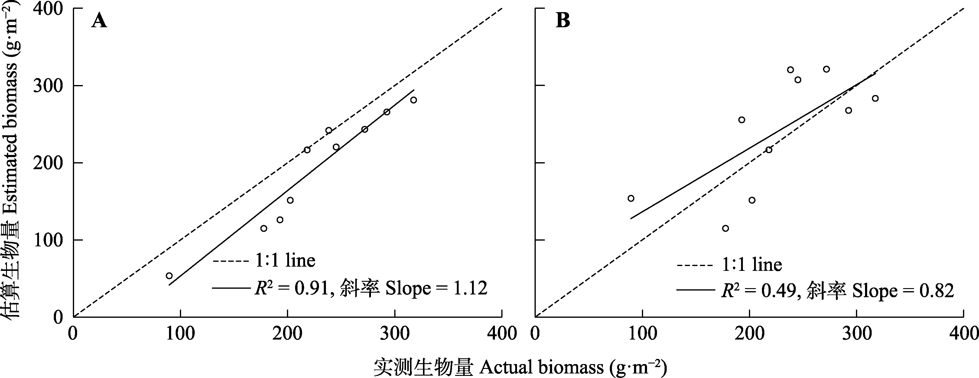
图5 生长季不同时期建模(A)和单一时期(9月)建模(B)下高寒草地地上生物量的估算精度。实测生物量值是2018年生长季每次野外测定生物量的平均值(n = 10); 估算生物量值通过最优经验拟合模型和物候相机归一化植被指数计算获得。
Fig. 5 Estimation of alpine grassland aboveground biomass using models in different phases of growing season (A) and at a single time (September)(B). The actual biomass is the averaged biomass for each measurement during the growing season of 2018 (n = 10). The estimated biomass is calculated by the optimal model and normalized difference of vegetation index measured by NetCam.
| [1] |
Beck PSA,Atzberger C,Arild Høgda K,Johansen B,Skidmore AK(2006).Improved monitoring of vegetation dynamics at very high latitudes: a new method using MODIS NDVI.Remote Sensing of Environment,100, 321-334.
DOI URL |
| [2] | Busetto L,Colombo R,Migliavacca M,Cremonese E,Meroni M,Galvagno M,Rossini M,Siniscalco C,Morra Di Cella U,Pari E(2010).Remote sensing of larch phenological cycle and analysis of relationships with climate in the Alpine region.Global Change Biology,16, 2504-2517. |
| [3] | Chen DL,Xu BQ,Yao TD,Guo ZT,Cui P,Chen FH,Zhang RH,Zhang XZ,Zhang YL(2015).Assessment of past, present and future environmental changes on the Tibetan Plateau.Chinese Science Bulletin,60, 3023-3035. |
| [陈德亮,徐柏青,姚檀栋,郭正堂,崔鹏,陈发虎,张人禾,张宪洲,张镱锂(2015).青藏高原环境变化科学评估: 过去、现在与未来.科学通报,60, 3023-3035.] | |
| [4] | Chen XQ,Wang LH(2009).Progress in remote sensing phenological research.Progress in Geography,28, 33-40. |
| [陈效逑,王林海(2009).遥感物候学研究进展.地理科学进展,28, 33-40.] | |
| [5] | Chu D,Deji YZ,Pubu CR,Ji QM,Tang H(2013a).Aboveground biomass in the North Tibet and estimate model using remote sensing data.Journal of Natural Resources,28, 2000-2011. |
| [除多,德吉央宗,普布次仁,姬秋梅,唐洪(2013a).藏北草地地上生物量及遥感监测模型研究.自然资源学报,28, 2000-2011.] | |
| [6] | Chu D,Pubu CR,Deji YZ,Ji QM,Tang H(2013b).Aboveground biomass estimate methods of grassland in the Central Tibet.Journal of Mountain Science,31, 664-671. |
| [除多,普布次仁,德吉央宗,姬秋梅,唐洪(2013b).西藏高原中部草地地上生物量遥感估算方法.山地学报,31, 664-671.] | |
| [7] | Craine JM,Nippert JB,Elmore AJ,Skibbe AM,Hutchinson SL,Brunsell NA(2012).Timing of climate variability and grassland productivity.Proceedings of the National Academy of Sciences of the United States of America,109, 3401-3405. |
| [8] | Fan DQ,Zhao XS,Zhu WQ,Zheng ZT(2016).Review of influencing factors of accuracy of plant phenology monitoring based on remote sensing data.Progress in Geography,35, 304-319. |
| [范德芹,赵学胜,朱文泉,郑周涛(2016).植物物候遥感监测精度影响因素研究综述.地理科学进展,35, 304-319.] | |
| [9] |
Filippa G,Cremonese E,Migliavacca M,Galvagno M,Sonnentag O,Humphreys E,Hufkens K,Ryu Y,Verfaillie J,Morra di Cella U,Richardson AD(2018).NDVI derived from near-infrared-enabled digital cameras: applicability across different plant functional types.Agricultural and Forest Meteorology,249, 275-285.
DOI URL |
| [10] | Ge J,Meng BP,Yang SX,Gao JL,Yin JP,Zhang RP,Feng QS,Liang TG(2017).Monitoring of above-ground biomass in alpine grassland based on agricultural digital camera and MODIS remote sensing data: a case study in the Yellow River Headwater Region.Acta Prataculturae Sinica,26, 23-34. |
| [葛静,孟宝平,杨淑霞,高金龙,殷建鹏,张仁平,冯琦胜,梁天刚(2017).基于ADC和MODIS遥感数据的高寒草地地上生物量监测研究——以黄河源区为例.草业学报,26, 23-34.] | |
| [11] |
He JS,Wang Z,Wang X,Schmid B,Zuo W,Zhou M,Zheng C,Wang M,Fang J(2006).A test of the generality of leaf trait relationships on the Tibetan Plateau.New Phytologist,170, 835-848.
DOI URL |
| [12] |
Huete A,Didan K,Miura T,Rodriguez EP,Gao X,Ferreira LG(2002).Overview of the radiometric and biophysical performance of the MODIS vegetation indices.Remote Sensing of Environment,83, 195-213.
DOI URL |
| [13] |
Jin Y,Yang X,Qiu J,Li J,Gao T,Wu Q,Zhao F,Ma H,Yu H,Xu B(2014).Remote sensing-based biomass estimation and its spatio-temporal variations in temperate grassland, northern China.Remote Sensing,6, 1496-1513.
DOI URL |
| [14] |
Jin YX,Xu B,Yang XC,Li JY,Wang DL,Ma HL(2011).Remote sensing dynamic estimation of grass production in Xilinguole, Inner Mongolia.Scientia Sinica Vitae,41, 1185-1195.
DOI URL |
| [金云翔,徐斌,杨秀春,李金亚,王道龙,马海龙(2011).内蒙古锡林郭勒盟草原产草量动态遥感估算.中国科学: 生命科学,41, 1185-1195.] | |
| [15] |
Klosterman S,Hufkens K,Richardson AD(2018).Later springs green-up faster: the relation between onset and completion of green-up in deciduous forests of North America.International Journal of Biometeorology,62, 1645-1655.
DOI PMID |
| [16] |
Liang TG,Yang SX,Feng QS,Liu BK,Zhang RP,Huang XD,Xie HJ(2016).Multi-factor modeling of above-ground biomass in alpine grassland: a case study in the Three-River Headwaters Region, China.Remote Sensing of Environment,186, 164-172.
DOI URL |
| [17] | Liu A,Liu DF(2005).A review of grassland biomass research in China.Inner Mongolia Prataculture,17, 7-11. |
| [刘艾,刘德福(2005).我国草地生物量研究概述.内蒙古草业,17, 7-11.] | |
| [18] | Liu F,Wang CK,Wang XC(2018).Application of near-surface remote sensing in monitoring the dynamics of forest canopy phenology.Chinese Journal of Applied Ecology,29, 1768-1778. |
| [刘帆,王传宽,王兴昌(2018).近地遥感在森林冠层物候动态监测中的应用.应用生态学报,29, 1768-1778.] | |
| [19] |
Main-Knorn M,Cohen WB,Kennedy RE,Grodzki W,Pflugmacher D,Griffiths P,Hostert P(2013).Monitoring coniferous forest biomass change using a Landsat trajectory-based approach.Remote Sensing of Environment,139, 277-290.
DOI URL |
| [20] |
Parton WJ,Scurlock JMO,Ojima DS,Schimel DS,Hall DO,Scopegram Group Members(1995).Impact of climate change on grassland production and soil carbon worldwide.Global Change Biology,1, 13-22.
DOI URL |
| [21] | Petach AR,Toomey M,Aubrecht DM,Richardson AD(2014).Monitoring vegetation phenology using an infrared-enabled security camera.Agricultural and Forest Meteorology, 195-196, 143-151. |
| [22] |
Piao S,Fang J,Zhou L,Tan K,Tao S(2007).Changes in biomass carbon stocks in Chinaʼs grasslands between 1982 and 1999.Global Biogeochemical Cycles,21, GB2002. DOI:10.1029/2005GB002634.
DOI |
| [23] |
Piao SL,Liu Q,Chen AP,Janssens IA,Fu YS,Dai JH,Liu LL,Lian X,Shen MG,Zhu XL(2019).Plant phenology and global climate change: current progresses and challenges.Global Change Biology,25, 1922-1940.
DOI URL |
| [24] |
Qiu J(2008).China: the third pole.Nature,454, 393-396.
DOI URL |
| [25] |
Scurlock JMO,Johnson K,Olson RJ(2002).Estimating net primary productivity from grassland biomass dynamics measurements.Global Change Biology,8, 736-753.
DOI URL |
| [26] |
Shen M,Piao S,Dorji T,Liu Q,Cong N,Chen X,An S,Wang S,Wang T,Zhang G(2015).Plant phenological responses to climate change on the Tibetan Plateau: research status and challenges.National Science Review,2, 454-467.
DOI URL |
| [27] |
Sonnentag O,Hufkens K,Teshera-Sterne C,Young AM,Friedl M,Braswell BH,Milliman T,O’Keefe J,Richardson AD(2012).Digital repeat photography for phenological research in forest ecosystems.Agricultural and Forest Meteorology,152, 159-177.
DOI URL |
| [28] |
Wang H,Liu H,Cao G,Ma Z,Li Y,Zhang F,Zhao X,Zhao X,Zhao X,Jiang L,Sanders NJ,Classen AT,He JS(2020).Alpine grassland plants grow earlier and faster but biomass remains unchanged over 35 years of climate change.Ecology Letters,23, 701-710.
DOI PMID |
| [29] | Wang WF,Lei YC,Wang XF,Zhao HY(2008).A review of forest biomass models.Journal of Northwest Forestry University,23, 58-63. |
| [王维枫,雷渊才,王雪峰,赵浩彦(2008).森林生物量模型综述.西北林学院学报,23, 58-63.] | |
| [30] | Wang ZX,Liu C,Huete A(2003).From AVHRR-NDVI to MODIS-EVI: advances in vegetation index research.Acta Ecologica Sinica,23, 979-987. |
| [王正兴,刘闯,Huete A(2003).植被指数研究进展: 从AVHRR-NDVI到MODIS-EVI.生态学报,23, 979-987.] | |
| [31] |
Wingate L,Ogée J,Cremonese E,Filippa G,Mizunuma T,Migliavacca M,Moisy C,Wilkinson M,Moureaux C,Wohlfahrt G,Hammerle A,Hörtnagl L,Gimeno C,Porcar- Castell A,Galvagno M,et al.(2015).Interpreting canopy development and physiology using a European phenology camera network at flux sites.Biogeosciences,12, 5995-6015.
DOI URL |
| [32] | Xia CF,Li J,Liu QH(2013).Review of advances in vegetation phenology monitoring by remote sensing.Journal of Remote Sensing,17, 1-16. |
| [夏传福,李静,柳钦火(2013).植被物候遥感监测研究进展.遥感学报,17, 1-16.] | |
| [33] |
Xu B,Yang XC,Tao WG,Miao JM,Yang Z,Liu HQ,Jin YX,Zhu XH,Qin ZH,Lv HY,Li JY(2013).MODIS-based remote-sensing monitoring of the spatiotemporal patterns of China’s grassland vegetation growth.International Journal of Remote Sensing,34, 3867-3878.
DOI URL |
| [34] |
Xu W,Zhu MY,Zhang Z,Ma ZZ,Liu HH,Chen LT,Cao GM,Zhao XQ,Schmid B,He JS(2018).Experimentally simulating warmer and wetter climate additively improves rangeland quality on the Tibetan Plateau.Journal of Applied Ecology,55, 1486-1497.
DOI URL |
| [35] |
Yahdjian L,Sala OE(2006).Vegetation structure constrains primary production response to water availability in the Patagonian Steppe.Ecology,87, 952-962.
PMID |
| [36] | Yang J,Guo N,Huang LN,Jia JH(2008).Analyses on MODIS-NDVI index saturation in northwest China.Plateau Meteorology,27(4), 198-205. |
| [杨嘉,郭铌,黄蕾诺,贾建华(2008).西北地区MODIS-NDVI指数饱和问题分析.高原气象,27(4), 198-205.] | |
| [37] | Yang SX,Feng QS,Meng BP,Gao JL,Ge J,Liang TG(2018).Temporal and spatial dynamics of alpine grassland biomass in the Three-River Headwater Region.Pratacultural Science,35, 956-968. |
| [杨淑霞,冯琦胜,孟宝平,高金龙,葛静,梁天刚(2018).三江源地区高寒草地地上生物量时空动态变化.草业科学,35, 956-968.] | |
| [38] |
Yang YH(2018).Ecological processes in alpine ecosystems under changing environment.Chinese Journal of Plant Ecology,42, 1-5.
DOI URL |
| [杨元合(2018).全球变化背景下的高寒生态过程.植物生态学报,42, 1-5.] | |
| [39] |
Zhang B,Zhang L,Xie D,Yin X,Liu C,Liu G(2016).Application of synthetic NDVI time series blended from Landsat and MODIS data for grassland biomass estimation.Remote Sensing,8, 10. DOI:10.3390/rs8010010.
DOI URL |
| [40] | Zhang XC,Zhu HZ,Zhong HP,Cheng YD,Jin GL,Shao XM(2015).Assessment of above-ground biomass of grassland using remote sensing, Yili, Xinjiang.Acta Prataculturae Sinica, (6), 25-34. |
| [张旭琛,朱华忠,钟华平,程耀东,靳瑰丽,邵小明(2015).新疆伊犁地区草地植被地上生物量遥感反演.草业学报, (6), 25-34.] | |
| [41] | Zhou YT,Fu G,Shen ZX,Zhang XZ,Wu JS,Li YL,Yang PW(2013).Estimation model of aboveground biomass in the Northern Tibet Plateau based on remote sensing date.Acta Prataculturae Sinica,22, 120-129. |
| [周宇庭,付刚,沈振西,张宪洲,武建双,李云龙,杨鹏万(2013).藏北典型高寒草甸地上生物量的遥感估算模型.草业学报,22, 120-129.] | |
| [42] |
Zhu X,Liu D(2015).Improving forest aboveground biomass estimation using seasonal Landsat NDVI time-series.ISPRS Journal of Photogrammetry and Remote Sensing,102, 222-231.
DOI URL |
| [1] | 张安宁, 肖亚宁, 赵霞, 张淼, 崔瀚文, 陈书燕, 安黎哲. 青藏高原灌木化与氮添加对土壤线虫及功能性状的交互作用[J]. 植物生态学报, 2026, 50(预发表): 0-. |
| [2] | 贾元, 张琳, 宋创业, 赵常明, 郭虓, 祝晓光, 吴冬秀. 基于深度学习目标检测的植物物候自动识别方法对比研究——以神农架粉白杜鹃为例[J]. 植物生态学报, 2026, 50(生态统计方法专题): 1-. |
| [3] | 张永军, 李敬东, 安琦, 洪翎桂, 任正炜, 张蕊, 周小龙. 氮添加和增温对天山高寒草地群落性状的影响[J]. 植物生态学报, 2026, 50(2): 417-428. |
| [4] | 徐恩相, 周蕾, 章晓炜, 张国萍, 仲杜伟, 黄智, 刘派, 迟永刚. 基于不同生育阶段冠层光谱和碳通量的水稻产量估算[J]. 植物生态学报, 2026, 50(1): 82-93. |
| [5] | 吕卫东, 董全民, 孙彩彩, 刘文亭, 刘玉祯, 张振祥, 李梦棋, 杨晓霞. 牦牛和藏羊放牧对高寒草地植物和微生物碳氮库的影响[J]. 植物生态学报, 2025, 49(9): 1424-1433. |
| [6] | 宋珊珊, 唐志尧. 河北塞罕坝草甸草原根际土壤真菌与植物地上生物量的关系[J]. 植物生态学报, 2025, 49(9): 1461-1471. |
| [7] | 严文秀, 赵诗晗, 郑春燕, 张萍, 沈海花, 常锦峰, 徐亢. 基于多物候指标的人工饲草长势监测及产量估测[J]. 植物生态学报, 2025, 49(7): 1096-1109. |
| [8] | 陈龙, 郭柯, 勾晓华, 赵秀海, 马泓若. 祁连圆柏林群落组成及特征[J]. 植物生态学报, 2025, 49(6): 852-864. |
| [9] | 王世松, 曲孝云, 董劭琼, 李佳鸿, 杨琦, 侯满福, 赵利清, 郭柯, 刘长成, 胥晓. 西藏札达典型荒漠植被类型及群落特征[J]. 植物生态学报, 2025, 49(5): 801-812. |
| [10] | 王娟, 张登山, 肖元明, 裴全帮, 王博, 樊博, 周国英. 长期围封后高寒草原植物根系分泌物特征与环境因子关系[J]. 植物生态学报, 2025, 49(4): 596-609. |
| [11] | 万冬梅, 杨智杰, 刘小飞, 熊德成, 胥超, 陈仕东, 杨玉盛. 基于固态激光雷达测高法的亚热带幼树生长物候及其对环境因子的响应[J]. 植物生态学报, 2025, 49(12): 2080-2091. |
| [12] | 陈诚智, 高钰森, 罗力嘉, 王东. 川西高寒窄叶鲜卑花灌丛凋落枝和凋落叶生产与分解[J]. 植物生态学报, 2025, 49(10): 1733-1743. |
| [13] | 王麟, 李雪, 王愉, 王新, 胡小文, 杨梅, 朱剑霄. 不同配方种衣剂对高寒草地乡土草种种子生长与建植的影响[J]. 植物生态学报, 2025, 49(1): 118-128. |
| [14] | 牛亚平, 高晓霞, 姚世庭, 杨元合, 彭云峰. 退化高寒草地植物多样性和功能群组成与地上生产力的关系[J]. 植物生态学报, 2025, 49(1): 83-92. |
| [15] | 王雯莹, 肖元明, 王小赟, 徐嘉昕, 马玉花, 李强峰, 周国英. 多功能群物种配置模式下退化高寒草甸植物多样性与生态系统多功能性的关联[J]. 植物生态学报, 2025, 49(1): 103-117. |
| 阅读次数 | ||||||
|
全文 |
|
|||||
|
摘要 |
|
|||||
Copyright © 2026 版权所有 《植物生态学报》编辑部
地址: 北京香山南辛村20号, 邮编: 100093
Tel.: 010-62836134, 62836138; Fax: 010-82599431; E-mail: apes@ibcas.ac.cn, cjpe@ibcas.ac.cn
备案号: 京ICP备16067583号-19
![]()