
植物生态学报 ›› 2006, Vol. 30 ›› Issue (2): 268-277.DOI: 10.17521/cjpe.2006.0036 cstr: 32100.14.cjpe.2006.0036
曹鑫1, 辜智慧1, 陈晋1( ), 刘晋2, 史培军1
收稿日期:2005-01-20
接受日期:2005-06-17
出版日期:2006-01-20
发布日期:2006-03-30
基金资助:
CAO Xin1, GU Zhi_Hui1, CHEN Jin1(), LIU Jin2, SHI Pei_Jun1
Received:2005-01-20
Accepted:2005-06-17
Online:2006-01-20
Published:2006-03-30
摘要:
干旱、半干旱地区草原退化是我国重要的生态和经济问题,其通常是自然与人为因素综合影响的结果。而区分这两者的影响,无疑对草原退化的恢复重建工作具有重要的意义。该文在基于前人的工作基础上,发展了一种分时段的回归分析和残差分析相结合的方法来评价人为因素在草地退化区域中的影响趋势。具体而言,以内蒙古自治区锡林郭勒草原为例,利用1983~1999年8 km空间分辨率的逐旬NOAA/AVHRR NDVI数据及同期气象数据为基础数据源,对每个像元建立1983~1988年的气候因子(考虑温度、降水,及其时滞效应)与NDVI的回归关系模型,并逐年分析1989~1999年回归关系模型的预测NDVI值与实际NDVI的残差及变化趋势,从而判断以1983~1988年为基准各像元受人为因素影响的趋势。结果表明,除东乌珠穆沁旗以外,锡林郭勒草原的各旗(市)20世纪90年代都出现了较为严重的人类活动影响加剧的草原退化,但退化的严重程度不一,呈现出东部和中部较轻、西部较重的空间格局,整个研究区域已达到中等退化程度。该结果与锡林郭勒草原退化的现状基本相吻合。
曹鑫, 辜智慧, 陈晋, 刘晋, 史培军. 基于遥感的草原退化人为因素影响趋势分析. 植物生态学报, 2006, 30(2): 268-277. DOI: 10.17521/cjpe.2006.0036
CAO Xin, GU Zhi_Hui, CHEN Jin, LIU Jin, SHI Pei_Jun. ANALYSIS OF HUMAN_INDUCED STEPPE DEGRADATION BASED ON REMOTE SENSING IN XILIN GOLE, INNER MONGOLIA, CHINA. Chinese Journal of Plant Ecology, 2006, 30(2): 268-277. DOI: 10.17521/cjpe.2006.0036
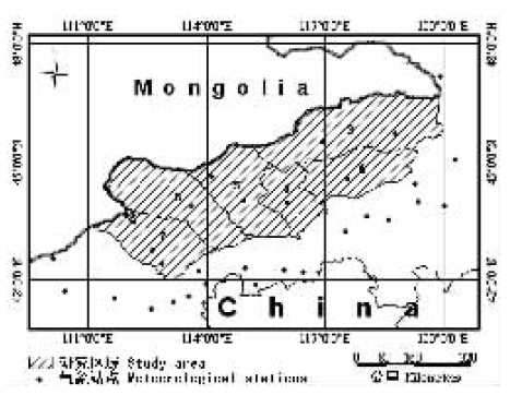
图1 研究区域和气象站点的分布 1. 锡林浩特市 Xilinhote 2. 二连浩特市 Erenhot 3. 东乌珠穆沁旗 East Ujumchin Banner 4. 西乌珠穆沁旗 West Ujumchin Banner 5. 阿巴嘎旗 Abarger Banner 6. 苏尼特左旗 East Sonid Banner 7. 苏尼特右旗 West Sonid Banner
Fig.1 Study area and location of meteorological stations
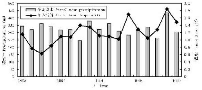
图2 31个气象站点的平均降水量和平均温度
Fig.2 Change of mean precipitation and temperature for 31 meteorological stations during 1983-1999
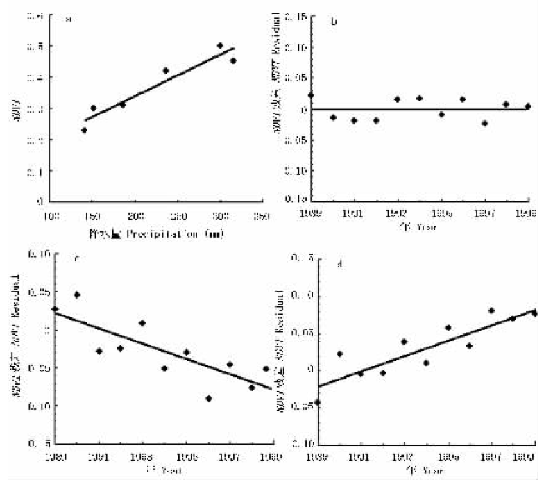
图3 残差分析法示例 a为NDVI与ΣP的相关关系,b、c、d为NDVI残差年际变化趋势 a is linear regression betweenΣP and NDVI, and b, c and d are temporal trends of NDVI residuals
Fig.3 Residual analysis to discriminate human_induced steppe degradation
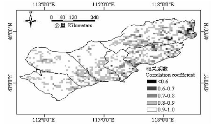
图4 1983~1988年气候因子与NDVI最大值的相关系数分布图
Fig.4 Distribution of correlation coefficients of regression analysis during 1983-1988
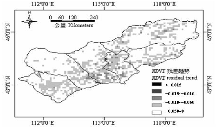
图5 1983~1988年残差趋势分布图
Fig.5 Residual trend during 1983-1988
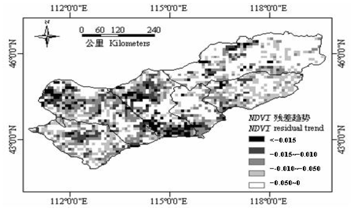
图6 1989~1999年残差趋势分布及人为因素导致的草原退化区域
Fig.6 Residual trend during 1989-1999 and human_induced steppe degradation
| 极严重 Extremely degradation <-0.015 | 严重 Severely degradation -0.015~-0.010 | 中等 Moderately degradation -0.010~-0.005 | 轻微 Slight degradation -0.005~0 | 总退化比例 Percent of degradation (%) | 平均残差趋势 Mean trend of residual error (平均斜率) (Mean slope coefficient) | ||||
|---|---|---|---|---|---|---|---|---|---|
| 锡林浩特 Xilinhote | 3.30% | 5.66% | 13.21% | 18.40% | 40.57% | -0.003 9 | |||
| 阿巴嘎旗 Abarger Banner | 13.77% | 14.03% | 16.88% | 14.55% | 59.22% | -0.011 9 | |||
| 东乌珠穆沁旗 East Ujumchin Banner | 3.03% | 3.94% | 6.21% | 13.94% | 27.12% | 0.001 8 | |||
| 西乌珠穆沁旗 West Ujumchin Banner | 1.80% | 5.39% | 19.76% | 33.23% | 60.18% | -0.008 6 | |||
| 苏尼特左旗 East Sonid Banner | 8.40% | 12.40% | 22.00% | 19.20% | 62.00% | -0.013 3 | |||
| 苏尼特右旗 West Sonid Banner | 1.44% | 11.78% | 17.53% | 27.59% | 58.33% | -0.007 2 | |||
表1 内蒙古锡林郭勒草原各旗(市)人为因素导致的退化面积比例
Table 1 Human_induced steppe degradation areas of different degradation classes for each county
| 极严重 Extremely degradation <-0.015 | 严重 Severely degradation -0.015~-0.010 | 中等 Moderately degradation -0.010~-0.005 | 轻微 Slight degradation -0.005~0 | 总退化比例 Percent of degradation (%) | 平均残差趋势 Mean trend of residual error (平均斜率) (Mean slope coefficient) | ||||
|---|---|---|---|---|---|---|---|---|---|
| 锡林浩特 Xilinhote | 3.30% | 5.66% | 13.21% | 18.40% | 40.57% | -0.003 9 | |||
| 阿巴嘎旗 Abarger Banner | 13.77% | 14.03% | 16.88% | 14.55% | 59.22% | -0.011 9 | |||
| 东乌珠穆沁旗 East Ujumchin Banner | 3.03% | 3.94% | 6.21% | 13.94% | 27.12% | 0.001 8 | |||
| 西乌珠穆沁旗 West Ujumchin Banner | 1.80% | 5.39% | 19.76% | 33.23% | 60.18% | -0.008 6 | |||
| 苏尼特左旗 East Sonid Banner | 8.40% | 12.40% | 22.00% | 19.20% | 62.00% | -0.013 3 | |||
| 苏尼特右旗 West Sonid Banner | 1.44% | 11.78% | 17.53% | 27.59% | 58.33% | -0.007 2 | |||
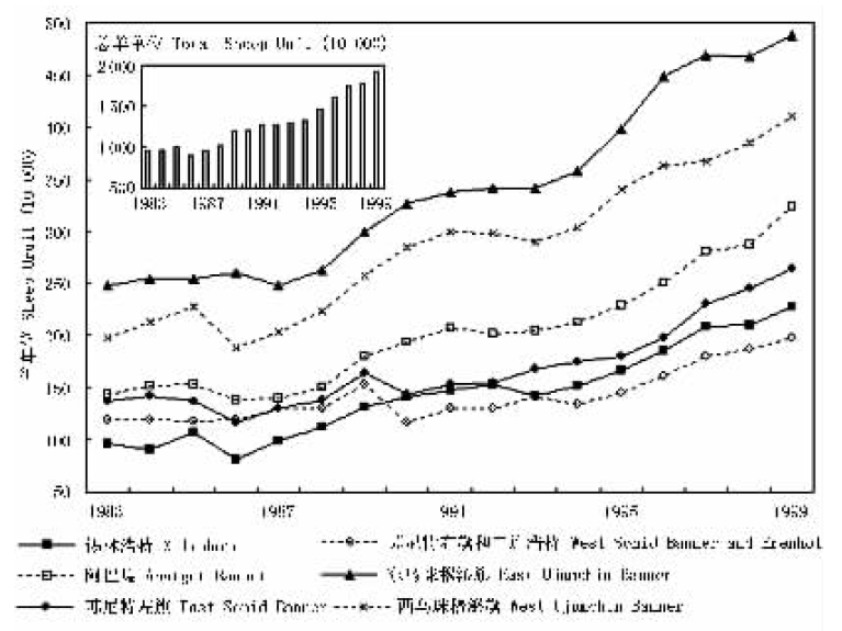
图7 锡林郭勒草原各旗(市)年牲畜总头数(1983~1999)
Fig.7 Annual total livestock in each county of Xilin Gole Steppe (1983-1999)
| 1983~1988 年均增长率 Mean rate of increase during 1983-1988 | 1989~1999 年均增长率 Mean rate of increase during 1989-1999 | 1990s与1980s 增长率之差 Difference of increase rate between 1990s and 1980s | 1999年单位面积载畜量 (羊单位·km-2) Stocking density in 1999 (sheep·km-2) | |
|---|---|---|---|---|
| 锡林浩特Xilinhote | 4.9% | 6.8% | 1.9% | 121.5 |
| 阿巴嘎旗Abarger Banner | 1.1% | 7.4% | 6.3% | 121.7 |
| 东乌珠穆沁旗East Ujumchin Banner | 1.3% | 5.9% | 4.6% | 89.4 |
| 西乌珠穆沁旗West Ujumchin Banner | 3.2% | 5.8% | 2.6% | 181.8 |
| 苏尼特左旗East Sonid Banner | 0.7% | 6.3% | 5.7% | 79.5 |
| 苏尼特右旗West Sonid Banner | 1.8% | 4.5% | 2.7% | 72.8 |
表2 锡林郭勒草原各旗(市)载畜量统计表
Table 2 Statistics of livestock of each county in Xilin Gole Steppe
| 1983~1988 年均增长率 Mean rate of increase during 1983-1988 | 1989~1999 年均增长率 Mean rate of increase during 1989-1999 | 1990s与1980s 增长率之差 Difference of increase rate between 1990s and 1980s | 1999年单位面积载畜量 (羊单位·km-2) Stocking density in 1999 (sheep·km-2) | |
|---|---|---|---|---|
| 锡林浩特Xilinhote | 4.9% | 6.8% | 1.9% | 121.5 |
| 阿巴嘎旗Abarger Banner | 1.1% | 7.4% | 6.3% | 121.7 |
| 东乌珠穆沁旗East Ujumchin Banner | 1.3% | 5.9% | 4.6% | 89.4 |
| 西乌珠穆沁旗West Ujumchin Banner | 3.2% | 5.8% | 2.6% | 181.8 |
| 苏尼特左旗East Sonid Banner | 0.7% | 6.3% | 5.7% | 79.5 |
| 苏尼特右旗West Sonid Banner | 1.8% | 4.5% | 2.7% | 72.8 |
| [1] | Chen J, Jonsson P, Tamura M, Gu ZH, Matsushita B, Eklundh L (2004). A simple method for reconstructing a high_quality NDVI time_series data set based on the Savitzky_Golay filter . Remote Sensing of Environment, 91,332-344. |
| [2] | Davidson A, Csillag F (2003). A comparison of three approaches for predicting C 4 species cover of northern mixed grass prairie . Remote Sensing of Environment, 86,70-82. |
| [3] | Del Valle HF, Elissalde NO, Gagliardini DA, Milovich J (1998). Status of desertification in the Patagonian region: assessment and mapping from satellite imagery. Arid Soil Research and Rehabilitation, 12,95-121. |
| [4] | Evans J, Geerken R (2004). Discrimination between climate and human_induced dryland degradation. Journal of Arid Environments, 57,535-554. |
| [5] | Geerken R, Ilaiwi M (2004). Assessment of rangeland degradation and development of a strategy for rehabilitation. Remote Sensing of Environment, 90,490-504. |
| [6] | James ME, Kalluri SNV (1994). The pathfinder AVHRR land data set: an improved coarse resolution data set for terrestrial monitoring. International Journal of Remote Sensing, 15,3347-3363. |
| [7] | Li B (李博) (1997). Steppe degradation and its prevention in North China. Sientia Agricultura Sinica (中国农业科学), 30(6),1-9. (in Chinese with English abstract) |
| [8] | Li XB (李晓兵), Shi PJ (史培军) (2000). Sensitivity analysis of variation in NDVI, temperature and precipitation in typical vegetation types across China . Acta Phytoecologica Sinica (植物生态学报), 24,379-382. (in Chinese with English abstract) |
| [9] | Li YH (李永宏) (1995). Restoration dynamics of degraded grasslands in the typical steppe zone of Inner Mongolia. Chinese Biodiversity (生物多样性), 3,125-130. (in Chinese with English abstract) |
| [10] | Liu ZL (刘钟龄), Wang W (王炜), Hao DY (郝敦元), Liang CZ (梁存柱) (2002). Probes on the degeneration and recovery succession mechanisms of Inner Mongolia Steppe. Journal of Arid Land Resources and Environment (干旱区资源与环境), 26,84-91. (in Chinese with English abstract) |
| [11] | Liu ZM (刘志明), Yan M (晏明), Wang GQ (王贵卿), Meng H (孟华), Zhang WZ (张文哲), Wang CH (王春晖) (2001). Analysis on grassland degeneration in the West Jilin Province based on satellite RS. Scientia Geographica Sinica (地理科学), 24,452-456. (in Chinese with English abstract) |
| [12] | Pan YZ (潘耀忠), Gong DY (龚道溢), Deng L (邓磊), Li J (李京), Gao J (高静) (2004). Smart distance searching_based and DEM_informed interpolation of surface air temperature in China . Acta Geographica Sinica (地理学报), 59,366-374. (in Chinese with English abstract) |
| [13] | Tong C (仝川), Yang JR (杨景荣), Yong WY (雍伟义), Yong SP (雍世鹏) (2002). Spatial pattern of steppe degradation in Xilin River basin of Inner Mongolia. Journal of Natural Resources (自然资源学报), 17,571-578. (in Chinese with English abstract) |
| [14] | Tong C, Wu J, Yong S, Yang J, Yong W (2004). A landscape_scale assessment of steppe degradation in the Xilin River Basin, Inner Mongolia, China. Journal of Arid Environments, 59,133-149. |
| [15] | Townshend JRG (1994). Global data sets for land applications from the Advance Very High Resolution Radiometer: an introduction. International Journal of Remote Sensing, 15,3319-3332. |
| [16] | Wang SP (汪诗平), Li YH (李永宏) (1999). Degradation mechanism of typical grassland in Inner Mongolia. Chinese Journal of Applied Ecology (应用生态学报), 10,437-441. (in Chinese with English abstract) |
| [17] | Wang W (王炜), Liu ZL (刘钟龄), Hao DY (郝敦元), Liang CZ (梁存柱) (1996a). Research on the restoring succession of the degenerated grassland in Inner Mongolia. I. Basic characteristics and driving force for restoration of the degenerated grassland. Acta Phytoecologica Sinica (植物生态学报), 20,449-459. (in Chinese with English abstract) |
| [18] | Wang W (王炜), Liu ZL (刘钟龄), Hao DY (郝敦元), Liang CZ (梁存柱) (1996b). Research on the restoring succession of the degenerated grassland in Inner Mongolia. II. Analysis of the restoring processes. Acta Phytoecologica Sinica (植物生态学报), 20,460-471. (in Chinese with English abstract) |
| [19] | Wang YR (王艳荣), Yong SP (雍世鹏) (2004). The use of multitemporal near_ground spectral reflectance to discriminate among degraded grasslands. Acta Phytoecologica Sinica (植物生态学报), 28,406-413. (in Chinese with English abstract) |
| [20] | Wu YN (乌云娜), Yang C (杨持) (1994). The quantitative analysis of steppe degenerating critical grade on Neimenggu Steppe. Acta Scientiarum Naturalium Universitatis Neimenggu (内蒙古大学学报自然科学版), 25,437-443. (in Chinese with English abstract) |
| [21] | Xue Y, Fennessy MD (2002). Under what conditions does land cover change impact regional climate? In: Reynolds JF, Stafford Smith DMS eds. Global Desertation: Do Humans Cause Deserts? Dahlem University Press, Berlin,59-74. |
| [1] | 何堂庆, 王变变, 曹鑫鑫, 张康成, 汪晓东, 王浩, 白彤硕, 赵叶新, 张艺, 王益, 仇云鹏, 胡水金. 半干旱草地植物和丛枝菌根真菌群落对长期降水增加的响应[J]. 植物生态学报, 2026, 50(3): 674-684. |
| [2] | 张法伟, 李红琴, 祝景彬, 樊博, 周华坤, 李英年, 梁乃申. 氮添加和降水改变对高寒草甸生态系统地上与地下碳储的影响[J]. 植物生态学报, 2025, 49(9): 1399-1409. |
| [3] | 郝杰, 刁华杰, 苏原, 武帅楷, 高阳阳, 梁雯君, 牛慧敏, 杨倩雯, 常婕, 王袼, 许雯丽, 马腾飞, 董宽虎, $\boxed{\hbox{王常慧}}$. 降水调控农牧交错带盐渍化草地净初级生产力对氮添加及刈割的响应[J]. 植物生态学报, 2025, 49(5): 710-719. |
| [4] | 韩菲, 王袼, 武帅楷, 林茂, 董宽虎, $\boxed{\hbox{王常慧}}$, 苏原. 极端降水对不同草原土壤总硝化及总氮矿化速率及其敏感性的影响[J]. 植物生态学报, 2025, 49(5): 697-709. |
| [5] | 李欣怡, 张丽芳, 吴友贵, 郭静, 兰荣光, 吕洪飞, 于明坚. 不同海拔高度下百山祖冷杉幼苗的生长特征及其影响因素[J]. 植物生态学报, 2025, 49(4): 610-623. |
| [6] | 葛小彩, 李锦隆, 孙俊, 武盼盼, 胡丹丹, 程栋梁, 钟全林. 武夷山亚高山草甸土壤呼吸组分特征及影响因素[J]. 植物生态学报, 2025, 49(3): 502-512. |
| [7] | 赵梦扬, 庄淏然, 许德浩, 马国荣, 马永成, 冯克鹏. 干旱半干旱地区灌区玉米农田土壤植物大气连续体系统氢氧稳定同位素特征及其影响因素[J]. 植物生态学报, 2025, 49(2): 256-267. |
| [8] | 童金莲, 张博纳, 汤璐瑶, 叶琳峰, 李姝雯, 谢江波, 李彦, 王忠媛. C4植物狗尾草功能性状网络沿降水梯度带的区域分异规律[J]. 植物生态学报, 2025, 49(11): 1817-1832. |
| [9] | 孙佳美, 安冰儿, 刘伟, 王璟, 潘庆民. 草原植物繁殖体调控技术: “蘖芽岛”的培育与移植[J]. 植物生态学报, 2025, 49(1): 129-137. |
| [10] | 刘伟, 郝毅晴, 孙佳美, 王璟, 范冰, 郝建玺, 金那申, 潘庆民. 呼伦贝尔退化草原土壤养分调控的原理与技术[J]. 植物生态学报, 2025, 49(1): 138-147. |
| [11] | 马煦晗, 黄菊莹, 余海龙, 韩翠, 李冰. 降水量变化及氮添加下荒漠草原土壤有机碳及其易分解组分研究[J]. 植物生态学报, 2024, 48(8): 1065-1077. |
| [12] | 钱尼澎, 高浩鑫, 宋超杰, 董淳超, 刘琪璟. 长白山白桦径向生长季节动态及其对环境因子的响应[J]. 植物生态学报, 2024, 48(8): 1001-1010. |
| [13] | 张富崇, 于明含, 张建玲, 王平, 丁国栋, 何莹莹, 孙慧媛. 黑沙蒿应对降水变化的木质部与韧皮部协同响应机制[J]. 植物生态学报, 2024, 48(7): 903-914. |
| [14] | 张文瑾, 佘维维, 秦树高, 乔艳桂, 张宇清. 氮和水分添加对黑沙蒿群落优势植物叶片氮磷化学计量特征的影响[J]. 植物生态学报, 2024, 48(5): 590-600. |
| [15] | 王袼, 胡姝娅, 李阳, 陈晓鹏, 李红玉, 董宽虎, 何念鹏, 王常慧. 不同类型草原土壤净氮矿化速率的温度敏感性[J]. 植物生态学报, 2024, 48(4): 523-533. |
| 阅读次数 | ||||||
|
全文 |
|
|||||
|
摘要 |
|
|||||
Copyright © 2026 版权所有 《植物生态学报》编辑部
地址: 北京香山南辛村20号, 邮编: 100093
Tel.: 010-62836134, 62836138; Fax: 010-82599431; E-mail: apes@ibcas.ac.cn, cjpe@ibcas.ac.cn
备案号: 京ICP备16067583号-19
![]()