
植物生态学报 ›› 2020, Vol. 44 ›› Issue (6): 628-641.DOI: 10.17521/cjpe.2019.0281 cstr: 32100.14.cjpe.2019.0281
周雄1, 孙鹏森1,*( ), 张明芳2, 刘世荣1
收稿日期:2019-10-22
接受日期:2020-03-02
出版日期:2020-06-20
发布日期:2020-05-30
基金资助:
ZHOU Xiong1, SUN Peng-Sen1,*(), ZHANG Ming-Fang2, LIU Shi-Rong1
Received:2019-10-22
Accepted:2020-03-02
Online:2020-06-20
Published:2020-05-30
Supported by:摘要:
水分利用效率(WUE)是深入理解生态系统水碳循环及其耦合关系的重要指标。为了揭示气候变化背景下区域尺度不同植被类型的响应和适应特征, 对中国西南高山亚高山地区2000-2014年的9种植被类型的WUE时空特征及其影响因素进行探究。该研究基于MODIS总初级生产力(GPP)、蒸散发(ET)数据和气象数据, 估算西南高山亚高山区植被WUE, 采用趋势分析及相关分析等方法, 分析了研究区植被WUE与气温、降水及海拔的关系。主要结果: (1)西南高山亚高山区2000-2014年植被WUE多年均值为0.95 g·m-2·mm-1, 整体呈显著增加趋势, 增速为0.011 g·m-2·mm-1·a-1; 空间上WUE呈东南高西北低的分布, 85.84%区域的WUE呈增加趋势。(2)西南高山亚高山区各植被类型WUE多年均值表现为常绿针叶林>稀树草原>常绿阔叶林>有林草原>农田>落叶阔叶林>混交林>郁闭灌丛>草地; 时间上, 各植被类型WUE均呈上升趋势。(3)西南高山亚高山区89.56%区域的WUE与气温正相关, 92.54%区域的WUE与降水量负相关; 各植被类型中, 草地WUE与气温的相关性最高, 有林草原WUE与降水量的相关性最高。(4)西南高山亚高山区典型的地带性顶极植被常绿针叶林的WUE具有较强的海拔适应性及应对气候变化的能力。
周雄, 孙鹏森, 张明芳, 刘世荣. 西南高山亚高山区植被水分利用效率时空特征及其与气候因子的关系. 植物生态学报, 2020, 44(6): 628-641. DOI: 10.17521/cjpe.2019.0281
ZHOU Xiong, SUN Peng-Sen, ZHANG Ming-Fang, LIU Shi-Rong. Spatio-temporal characteristics of vegetation water use efficiency and their relationships with climatic factors in alpine and subalpine area of southwestern China. Chinese Journal of Plant Ecology, 2020, 44(6): 628-641. DOI: 10.17521/cjpe.2019.0281
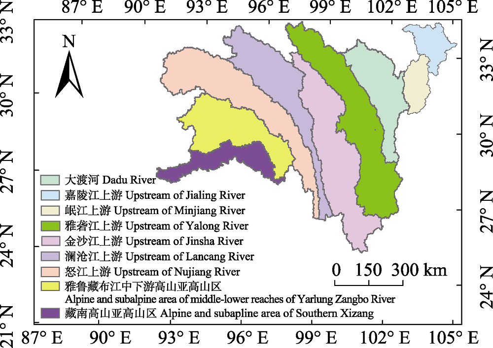
图1 西南高山亚高山区流域分布图。
Fig. 1 Watersheds distribution in the alpine and subalpine area of southwestern China.
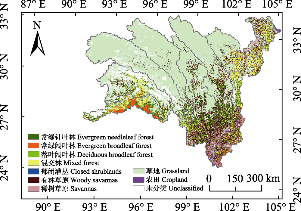
图2 西南高山亚高山区植被类型分类图。
Fig. 2 Vegetation map for the alpine and subalpine area of southwestern China.
| 植被类型 Vegetation type | 面积比例 Area ratio (%) | 平均海拔 Mean altitude (m) | 年平均气温 Mean annual air temperature (℃) | 年降水量 Mean annual precipitation (mm) |
|---|---|---|---|---|
| 常绿针叶林 Evergreen needleleaf forest | 7.22 | 3 243 | 7.97 | 846 |
| 常绿阔叶林 Evergreen broadleaf forest | 1.52 | 1 581 | 16.92 | 665 |
| 落叶阔叶林 Deciduous broadleaf forest | 1.59 | 2 706 | 8.48 | 897 |
| 混交林 Mixed forest | 8.51 | 1 941 | 7.75 | 576 |
| 郁闭灌丛 Closed shrublands | 0.02 | 3 328 | 9.33 | 817 |
| 有林草原 Woody savannas | 12.71 | 3 320 | 6.74 | 867 |
| 稀树草原 Savannas | 3.71 | 2 765 | 10.20 | 899 |
| 草地 Grassland | 63.64 | 4 434 | 1.15 | 733 |
| 农田 Cropland | 1.08 | 2 016 | 12.83 | 834 |
表1 西南高山亚高山区不同植被类型的面积比例、平均海拔、年平均气温和年降水量
Table 1 The area ratio, mean altitude, mean annual air temperature and precipitation of different vegetation types in the alpine and subalpine area of southwestern China
| 植被类型 Vegetation type | 面积比例 Area ratio (%) | 平均海拔 Mean altitude (m) | 年平均气温 Mean annual air temperature (℃) | 年降水量 Mean annual precipitation (mm) |
|---|---|---|---|---|
| 常绿针叶林 Evergreen needleleaf forest | 7.22 | 3 243 | 7.97 | 846 |
| 常绿阔叶林 Evergreen broadleaf forest | 1.52 | 1 581 | 16.92 | 665 |
| 落叶阔叶林 Deciduous broadleaf forest | 1.59 | 2 706 | 8.48 | 897 |
| 混交林 Mixed forest | 8.51 | 1 941 | 7.75 | 576 |
| 郁闭灌丛 Closed shrublands | 0.02 | 3 328 | 9.33 | 817 |
| 有林草原 Woody savannas | 12.71 | 3 320 | 6.74 | 867 |
| 稀树草原 Savannas | 3.71 | 2 765 | 10.20 | 899 |
| 草地 Grassland | 63.64 | 4 434 | 1.15 | 733 |
| 农田 Cropland | 1.08 | 2 016 | 12.83 | 834 |
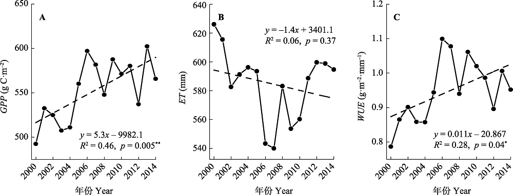
图3 2000-2014年西南高山亚高山区总初级生产力(GPP)(A)、蒸散(ET)(B)和水分利用效率(WUE)(C)年际变化。 *, p < 0.05; **, p < 0.01.
Fig. 3 Temporal trends of gross primary production (GPP)(A), evapotranspiration (ET)(B), and water use efficiency (WUE)(C) in the alpine and subalpine area of southwestern China from 2000 to 2014. *, p < 0.05; **, p < 0.01。
| 研究区域 Study region | 总初级生产力平均值 Mean GPP (g C·m-2) | 蒸散平均值 Mean ET (mm) | 水分利用效率平均值 Mean WUE (g·m-2·mm-1) | 水分利用效率变化趋势 Change rates of WUE (g·m-2·mm-1·a-1) |
|---|---|---|---|---|
| 嘉陵江上游 Upstream of Jialing River | 877 | 640 | 1.37 | -0.001 |
| 岷江上游 Upstream of Minjiang River | 833 | 722 | 1.15 | 0.004 |
| 大渡河 Dadu River | 634 | 614 | 1.03 | 0.007 |
| 雅砻江上游 Upstream of Yalong River | 697 | 544 | 1.28 | 0.013 |
| 金沙江上游 Upstream of Jinsha River | 731 | 535 | 1.37 | 0.021* |
| 澜沧江上游 Upstream of Lancang River | 295 | 515 | 0.57 | 0.011 |
| 怒江上游 Upstream of Nujiang River | 235 | 512 | 0.46 | 0.009* |
| 雅鲁藏布江中游高山亚高山区 Alpine and subalpine area of middle-lower reaches of Yarlung Zangbo River | 322 | 721 | 0.45 | 0.006 |
| 藏南高山亚高山区 Alpine and subalpine area of Southern Xizang | 909 | 814 | 1.12 | 0.011* |
表2 2000-2014年西南高山亚高山区各流域总初级生产力(GPP)、蒸散(ET)、水分利用效率(WUE)平均值、WUE变化趋势
Table 2 Mean gross primary production (GPP), evapotranspiration (ET), water use efficiency (WUE), and the change rates of WUE in different watersheds of the alpine and subalpine area of southwestern China from 2000 to 2014
| 研究区域 Study region | 总初级生产力平均值 Mean GPP (g C·m-2) | 蒸散平均值 Mean ET (mm) | 水分利用效率平均值 Mean WUE (g·m-2·mm-1) | 水分利用效率变化趋势 Change rates of WUE (g·m-2·mm-1·a-1) |
|---|---|---|---|---|
| 嘉陵江上游 Upstream of Jialing River | 877 | 640 | 1.37 | -0.001 |
| 岷江上游 Upstream of Minjiang River | 833 | 722 | 1.15 | 0.004 |
| 大渡河 Dadu River | 634 | 614 | 1.03 | 0.007 |
| 雅砻江上游 Upstream of Yalong River | 697 | 544 | 1.28 | 0.013 |
| 金沙江上游 Upstream of Jinsha River | 731 | 535 | 1.37 | 0.021* |
| 澜沧江上游 Upstream of Lancang River | 295 | 515 | 0.57 | 0.011 |
| 怒江上游 Upstream of Nujiang River | 235 | 512 | 0.46 | 0.009* |
| 雅鲁藏布江中游高山亚高山区 Alpine and subalpine area of middle-lower reaches of Yarlung Zangbo River | 322 | 721 | 0.45 | 0.006 |
| 藏南高山亚高山区 Alpine and subalpine area of Southern Xizang | 909 | 814 | 1.12 | 0.011* |
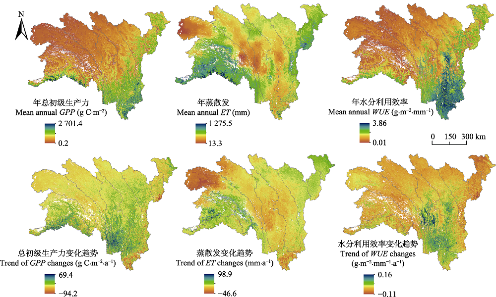
图4 2000-2014年西南高山亚高山区总初级生产力(GPP)、蒸散(ET)和水分利用效率(WUE)的空间分布及其变化趋势。
Fig. 4 Spatial distributions and change trends of gross primary production (GPP), evapotranspiration (ET) and water use efficiency (WUE) in the alpine and subalpine area of southwestern China from 2000 to 2014.
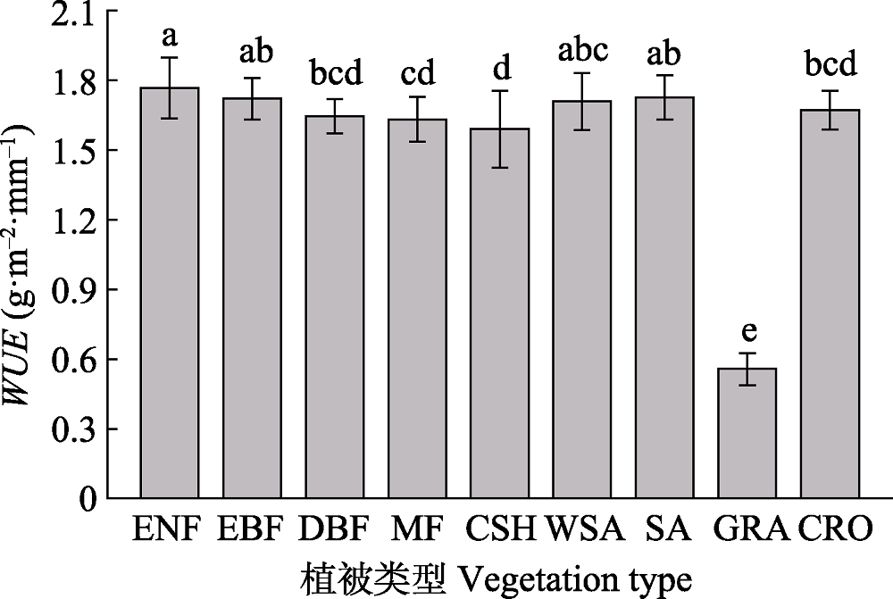
图5 2000-2014年西南高山亚高山区不同植被类型水分利用效率(WUE)的平均值(±标准偏差)。 CRO, 农田; CSH, 郁闭灌丛; DBF, 落叶阔叶林; EBF, 常绿阔叶林; ENF, 常绿针叶林; GRA, 草地; MF, 混交林; SA, 稀树草原; WSA, 有林草原。
Fig. 5 Mean water use efficiency (WUE ± SD) of different vegetation types in the alpine and subalpine area of southwestern China from 2000 to 2014. CRO, cropland; CSH, closed shrublands; DBF, deciduous broadleaf forest; EBF, evergreen broadleaf forest; ENF, evergreen needleleaf forest; GRA, grassland; MF, mixed forest; SA, savannas; WSA, woody savannas.
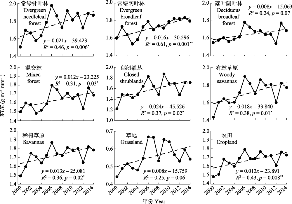
图6 2000-2014年西南高山亚高山区不同植被类型水分利用效率(WUE)年际变化。 *, p < 0.05; **, p < 0.01。
Fig. 6 Temporal trends of water use efficiency (WUE) of different vegetation types in the alpine and subalpine area of southwestern China from 2000 to 2014. *, p < 0.05; **, p < 0.01.
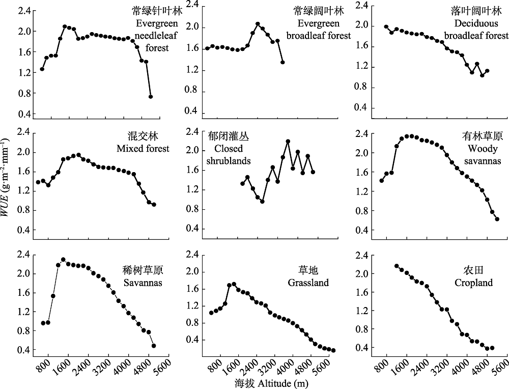
图7 西南高山亚高山区不同植被类型水分利用效率(WUE)与海拔的关系。
Fig. 7 Relationships between water use efficiency (WUE) of different vegetation types and altitude in the alpine and subalpine area of southwestern China.
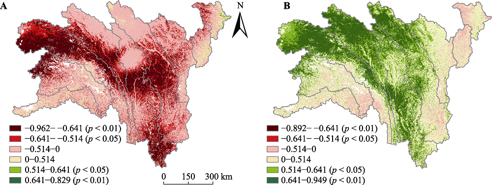
图8 2000-2014年西南高山亚高山区水分利用效率(WUE)与年降水量相关系数的空间分布(A), WUE与年平均气温相关系数的空间分布(B)。
Fig. 8 Spatial distribution of correlation coefficients between annual water use efficiency (WUE) and annual precipitation (A), correlation coefficients between annual WUE and annual air temperature (B) in the alpine and subalpine area of southwestern China from 2000 to 2014.
| 植被类型 Vegetation type | 常绿针叶林 Evergreen needleleaf forest | 常绿阔叶林 Evergreen broadleaf forest | 落叶阔叶林 Deciduous broadleaf forest | 混交林 Mixed forest | 郁闭灌丛 Closed shrublands | 有林草原 Woody savannas | 稀树草原 Savannas | 草地 Grassland | 农田 Cropland |
|---|---|---|---|---|---|---|---|---|---|
| WUE与降水量相关系数 Correlation coefficients between WUE and precipitation | -0.633* | -0.189 | -0.406 | -0.197 | -0.591* | -0.732** | -0.705** | -0.712** | -0.704** |
| WUE与气温相关系数 Correlation coefficients between WUE and air temperature | 0.628* | 0.255 | 0.599* | 0.548* | 0.808** | 0.715** | 0.513 | 0.814** | 0.416 |
表3 西南高山亚高山区不同植被类型水分利用效率(WUE)与年降水量和年平均气温的相关系数分析表
Table 3 Correlation coefficients between annual water use efficiency (WUE) and annual precipitation, and correlation coefficients between WUE and annual air temperature of different vegetation types in the alpine and subalpine area of southwestern China
| 植被类型 Vegetation type | 常绿针叶林 Evergreen needleleaf forest | 常绿阔叶林 Evergreen broadleaf forest | 落叶阔叶林 Deciduous broadleaf forest | 混交林 Mixed forest | 郁闭灌丛 Closed shrublands | 有林草原 Woody savannas | 稀树草原 Savannas | 草地 Grassland | 农田 Cropland |
|---|---|---|---|---|---|---|---|---|---|
| WUE与降水量相关系数 Correlation coefficients between WUE and precipitation | -0.633* | -0.189 | -0.406 | -0.197 | -0.591* | -0.732** | -0.705** | -0.712** | -0.704** |
| WUE与气温相关系数 Correlation coefficients between WUE and air temperature | 0.628* | 0.255 | 0.599* | 0.548* | 0.808** | 0.715** | 0.513 | 0.814** | 0.416 |
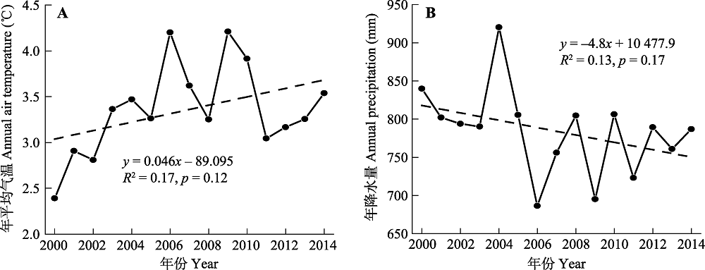
图9 2000-2014年西南高山亚高山区气温(A)和降水量(B)年际变化。
Fig. 9 Temporal trends of annual air temperature (A) and precipitation (B) in the alpine and subalpine area of southwestern China from 2000 to 2014.
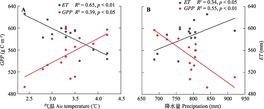
图10 2000-2014年西南高山亚高山区总初级生产力(GPP)和蒸散(ET)与气温(A)、降水量(B)的关系。
Fig. 10 Relationships between air temperature, gross primary production (GPP), and evapotranspiration (ET)(A), and between precipitation, GPP, and ET (B) in alpine and subalpine area of southwestern China from 2000 to 2014.
| [1] |
Chen XJ, Mo XG, Hu S, Liu SX (2017). Contributions of climate change and human activities to ET and GPP trends over North China Plain from 2000 to 2014. Journal of Geographical Sciences, 27, 661-680.
DOI URL |
| [2] |
Creed IF, Spargo AT, Jones JA, Buttle JM, Adams MB, Beall FD, Booth EG, Campbell JL, Clow D, Elder K, Green MB, Grimm NB, Miniat C, Ramlal P, Saha A, Sebestyen S, Spittlehouse D, Sterling S, Williams MW, Winkler R, Yao HX (2014). Changing forest water yields in response to climate warming: results from long-term experimental watershed sites across North America. Global Change Biology, 20, 3191-3208.
DOI URL |
| [3] |
Cregg BM, Zhang JW (2001). Physiology and morphology of Pinus sylvestris seedlings from diverse sources under cyclic drought stress. Forest Ecology and Management, 154, 131-139.
DOI URL |
| [4] |
Cui J, An SQ, Wang ZS, Fang CM, Liu YH, Yang HB, Xu Z, Liu SR (2009). Using deuterium excess to determine the sources of high-altitude precipitation: implications in hydrological relations between sub-alpine forests and alpine meadows. Journal of Hydrology, 373, 24-33.
DOI URL |
| [5] | Du XZ, Zhao X, Wang HY, He B (2018). Responses of terrestrial ecosystem water use efficiency to climate change: areview. Acta Ecologica Sinica, 38, 8296-8305. |
| [ 杜晓铮, 赵祥, 王昊宇, 何斌 (2018). 陆地生态系统水分利用效率对气候变化的响应研究进展. 生态学报, 38, 8296-8305.] | |
| [6] |
Feng XM, Fu BJ, Piao SL, Wang S, Ciais P, Zeng ZZ, Lü YH, Zeng Y, Li Y, Jiang XH, Wu BF (2016). Revegetation in China’s Loess Plateau is approaching sustainable water resource limits. Nature Climate Change, 6, 1019-1022.
DOI URL |
| [7] |
Gang C, Wang Z, Zhou W, Chen Y, Li J, Chen J, Qi J, Odeh I, Groisman PY (2016). Assessing the spatiotemporal dynamic of global grassland water use efficiency in response to climate change from 2000 to 2013. Journal of Agronomy and Crop Science, 202, 343-354.
DOI URL |
| [8] | Gu FX, Pang R, Zhang YD, Huang M, Li J, Hao WP, Mei XR (2014). Temporal-spatial variations of soil organic carbon and their responses to climate change in alpine area of southwest China during 1954-2010. Journal of Natural Resources, 29, 1930-1943. |
| [ 顾峰雪, 庞瑞, 张远东, 黄玫, 李洁, 郝卫平, 梅旭荣 (2014). 1954-2010年西南高山地区土壤碳储量时空动态及对气候变化的响应. 自然资源学报, 29, 1930-1943.] | |
| [9] |
Gunderson CA, Edwards NT, Walker AV, O’Hara KH, Campion CM, Hanson PJ (2012). Forest phenology and a warmer climate-growing season extension in relation to climatic provenance. Global Change Biology, 18, 2008-2025.
DOI URL |
| [10] |
Guo LM, Sun FB, Liu WB, Zhang YG, Wang H, Cui HJ, Wang HQ, Zhang J, Du BX (2019). Response of ecosystem water use efficiency to drought over China during 1982-2015: spatiotemporal variability and resilience. Forests, 10, 598. DOI: 10.3390/f1007059.
DOI URL |
| [11] | Heinsch FA, Reevrs M, Votava P, Kang SY, Milesi C, Zhao MS, Glassy J, Jolly WM, Loehman R, Bowker CF, Kimball JS, Nemani RR, Running SW (2003). GPP and NPP (MOD17A2/A3) Products, NASA MODIS Land Algorithm. MOD17 User’s Guide, 1-57. |
| [12] |
Heitman JL, Horton R, Sauer TJ, DeSutter TM (2008). Sensible heat observations reveal soil-water evaporation dynamics. Journal of Hydrometeorology, 9, 165-171.
DOI URL |
| [13] |
Hu ZM, Yu GR, Fan JW, Zhong HP, Wang SQ, Li SG (2010). Precipitation-use efficiency along a 4500-km grassland transect. Global Ecology and Biogeography, 19, 842-851.
DOI URL |
| [14] |
Hu ZM, Yu GR, Fu YL, Sun XM, Li YN, Shi PL, Wang YF, Zheng ZM (2008). Effects of vegetation control on ecosystem water use efficiency within and among four grassland ecosystems in China. Global Change Biology, 14, 1609-1619.
DOI URL |
| [15] | Hu ZM, Yu GR, Wang QF, Zhao FH (2009). Ecosystem level water use efficiency: a review. Acta Ecologica Sinica, 29, 1498-1507. |
| [ 胡中民, 于贵瑞, 王秋凤, 赵风华 (2009). 生态系统水分利用效率研究进展. 生态学报, 29, 1498-1507.] | |
| [16] |
Ito A, Inatomi M (2012). Water-use efficiency of the terrestrial biosphere: a model analysis focusing on interactions between the global carbon and water cycles. Journal of Hydrometeorology, 13, 681-694.
DOI URL |
| [17] |
Jackson RB, Jobbágy EG, Avissar R, Roy SB, Barrett DJ, Cook CW, Farley KA, Le Maitre DC, McCarl BA, Murray BC (2005). Trading water for carbon with biological carbon equestration. Science, 310, 1944-1947.
DOI URL PMID |
| [18] | Jia ZZ, Liu SM, Xu ZW, Chen YJ, Zhu MJ (2012). Validation of remotely sensed evapotranspiration over the Hai River Basin, China. Journal of Geophysical Research, 117, D13113. DOI: 10.1029/2011JD017037. |
| [19] |
Korner C, Basler D (2010). Phenology under global warming. Science, 327, 1461-1462.
DOI URL PMID |
| [20] | Li XJ, Zhang FP, Wang HW, Lei SJ, Gao Z (2017). Analysis of the spatio-temporal characteristics of water-use efficiency of vegetation and its relationship with climate in the Heihe River Basin. Journal of Desert Research, 37, 733-741. |
| [ 李肖娟, 张福平, 王虎威, 雷声剑, 高张 (2017). 黑河流域植被水分利用效率时空变化特征及其与气候因子的关系. 中国沙漠, 37, 733-741.] | |
| [21] | Li YH, Xue C (2017). Analysis of interannual variation characteristics of runoff in Zipingpu Reservoir. Sichuan Water Power, 36, 113-115, 132. |
| [ 黎永红, 薛晨 (2017). 紫坪铺水库入库径流年际变化特征分析. 四川水力发电, 36, 113-115, 132.] | |
| [22] | Liu Q, Wu N, Pan KW, Liu ZG, Chen QH (1999). Subalpine forest in the upper reaches of the Yangtze River and its environmental effects and reconstruction countermeasures// Xu HZ, Zhao QG. Flood Disasters in the Yangtze River Basin and Scientific and Technological Countermeasures. Science Press, Beijing. 79-83. |
| [ 刘庆, 吴宁, 潘开文, 刘照光, 陈庆恒 (1999). 长江上游亚高山森林及其环境效应重建对策//许厚泽, 赵其国. 长江流域洪涝灾害与科技对策. 科学出版社, 北京. 79-83.] | |
| [23] | Liu Q, Wu Y, He H (2001). Ecological problems of subalpine coniferous forest in the southwest of China. World Sci-Tech R&D, 23, 63-69. |
| [ 刘庆, 吴彦, 何海 (2001). 中国西南亚高山针叶林的生态学问题. 世界科技研究与发展, 23, 63-69.] | |
| [24] |
Liu XF, Hu BY, Ren ZY (2018). Spatiotemporal variation of water use efficiency and its driving forces on the Loess Plateau during 2000-2014. Scientia Agricultura Sinica, 51, 302-314.
DOI URL |
| [ 刘宪锋, 胡宝怡, 任志远 (2018). 黄土高原植被生态系统水分利用效率时空变化及驱动因素. 中国农业科学, 51, 302-314.] | |
| [25] |
Liu YB, Xiao JF, Ju WM, Zhou YL, Wang SQ, Wu XC (2015). Water use efficiency of China’s terrestrial ecosystems and responses to drought. Scientific Reports, 5, 13799-13811.
DOI URL PMID |
| [26] |
Liu YJ, Tao FL (2013). Response of crop water use efficiency to elevated temperature and CO2 concentration—A review. Progress in Geography, 32, 416-424.
DOI URL |
| [ 刘玉洁, 陶福禄 (2013). 作物水分利用效率对温度和CO2浓度升高的响应研究进展. 地理科学进展, 32, 416-424.] | |
| [27] |
Lu XL, Zhuang QL (2010). Evaluating evapotranspiration and water-use efficiency of terrestrial ecosystems in the conterminous United States using MODIS and AmeriFlux data. Remote Sensing of Environment, 114, 1924-1939.
DOI URL |
| [28] |
Monteith JL (1965). Evaporation and environment. Symposia of the Society for Experimental Biology, 19, 205-234.
URL PMID |
| [29] |
Mu QZ, Zhao MS, Running SW (2011). Improvements to a MODIS global terrestrial evapotranspiration algorithm. Remote Sensing of Environment, 115, 1781-1800.
DOI URL |
| [30] | Niu ZE, He HL, Zhu GF, Ren XL, Zhang L, Zhang K, Yu GR, Ge R, Li P, Zeng N, Zhu XB (2019). An increasing trend in the ratio of transpiration to total terrestrial evapotranspiration in China from 1982 to 2015 caused by greening and warming. Agricultural and Forest Meteorology, 279, 107701. DOI: 10.1016/j.agrformet.2019.107701. |
| [31] | Pang J, Qin J (2013). Advances in characteristics and causes of drought research in southwest China. Journal of Nanjing University of Information Science & Technology (Natural Science Edition), 5(2), 127-134. |
| [ 庞晶, 覃军 (2013). 西南干旱特征及其成因研究进展. 南京信息工程大学学报(自然科学版), 5(2), 127-134.] | |
| [32] | Pei TT, Li XY, Wu HW, Wu XC, Chen Y, Xie BP (2019). Sensitivity of vegetation water use efficiency to climate and vegetation index in Loess Plateau, China. Transactions of the Chinese Agricultural Engineering, 35, 119-125, 319. |
| [ 裴婷婷, 李小雁, 吴华武, 吴秀臣, 陈英, 谢保鹏 (2019). 黄土高原植被水分利用效率对气候和植被指数的敏感性研究. 农业工程学报, 35, 119-125, 319.] | |
| [33] |
Ponce-Campos GE, Moran MS, Huete A, Zhang YG, Bresloff C, Huxman TE, Eamus D, Bosch DD, Buda AR, Gunter SA, Scalley TH, Kitchen SG, McClaran MP, McNab WH, Montoya DS, Morgan JA, Peters DPC, Sadler EJ, Seyfried MS, Starks PJ (2013). Ecosystem resilience despite large-scale altered hydroclimatic conditions. Nature, 494, 349-352.
DOI URL |
| [34] | Qiu KB, Cheng JF (2015). Vegetation water use efficiency and its relationship with climate in Shaanxi Province. Research of Soil and Water Conservation, 22(6), 256-260. |
| [ 仇宽彪, 成军峰 (2015). 陕西省植被水分利用效率及与气候因素的关系. 水土保持研究, 22(6), 256-260.] | |
| [35] |
Sun PS, Liu N, Liu SR, Sun G (2016). Trade-offs between water yield and carbon sequestration for sub-alpine catchments in western Sichuan, China. Chinese Journal of Plant Ecology, 40, 1037-1048.
DOI URL |
| [ 孙鹏森, 刘宁, 刘世荣, 孙阁 (2016). 川西亚高山流域水碳平衡研究. 植物生态学报, 40, 1037-1048.] | |
| [36] |
Sun Y, Piao SL, Huang MT, Ciais P, Zeng ZZ, Cheng L, Li XR, Zhang XP, Mao JF, Peng SS, Poulter B, Shi XY, Wang XH, Wang YP, Zeng H (2016). Global patterns and climate drivers of water-use efficiency in terrestrial ecosystems deduced from satellite-based datasets and carbon cycle models. Global Ecology and Biogeography, 25, 311-323.
DOI URL |
| [37] |
Tang XG, Li HP, Desai AR, Nagy Z, Luo JH, Kolb TE, Olioso A, Xu XB, Yao L, Kutsch W, Pilegaard K, Köstner B, Ammann C (2014). How is water-use efficiency of terrestrial ecosystems distributed and changing on Earth? Scientific Reports, 4, 7483. DOI: 10.1038/srep07483.
DOI URL PMID |
| [38] |
Tian HQ, Chen GS, Liu ML, Zhang C, Sun G, Lu CQ, Xu XF, Ren W, Pan SF, Chappelka A (2010). Model estimates of net primary productivity, evapotranspiration, and water use efficiency in the terrestrial ecosystems of the southern United States during 1895-2007. Forest Ecology and Management, 259, 1311-1327.
DOI URL |
| [39] |
Wang F, Jiang H, Zhang XM (2015). Spatial-temporal dynamics of gross primary productivity, evapotranspiration, and water-use efficiency in the terrestrial ecosystems of the Yangtze River Delta region and their relations to climatic variables. International Journal of Remote Sensing, 36, 2654-2673.
DOI URL |
| [40] | Wei HJ, Zhang YF, Dong XB, Lu NC, Wang XC (2016). Estimating the spatio-temporal characteristic of vegetation water use efficiency over Weihe River Basin. Journal of Natural Resources, 31, 1275-1288. |
| [ 位贺杰, 张艳芳, 董孝斌, 鲁纳川, 王雪超 (2016). 渭河流域植被WUE遥感估算及其时空特征. 自然资源学报, 31, 1275-1288.] | |
| [41] | Wu GJ, Liu XH, Chen T, Xu GB, Wang WZ, Zeng XM, Zhang XW (2015). Elevation-dependent variations of tree growth and intrinsic water-use efficiency in Schrenk spruce ( Picea schrenkiana) in the western Tianshan Mountains, China. Frontiers in Plant Science, 6, 309. DOI: 103389/fps.2015.00309. |
| [42] | Xue BL, Guo QH, Otto A, Xiao JF, Tao SL, Li L (2015). Global patterns, trends, and drivers of water use efficiency from 2000 to 2013. Ecosphere, 6, 174. DOI: 10.1890/ES14-00416.1. |
| [43] |
Ye H, Wang JB, Huang M, Qi SH (2012). Spatial pattern of vegetation precipitation use efficiency and its response to precipitation and temperature on the Qinghai-Xizang Plateau of China. Chinese Journal of Plant Ecology, 36, 1237-1247.
DOI URL |
| [ 叶辉, 王军邦, 黄玫, 齐述华 (2012). 青藏高原植被降水利用效率的空间格局及其对降水和气温的响应. 植物生态学报, 36, 1237-1247.] | |
| [44] |
Zhang LX, Hu ZM, Fan JW, Shao QQ, Tang FP (2014). Advances in the spatiotemporal dynamics in ecosystem water use efficiency at regional scale. Advances in Earth Science, 29, 691-699.
DOI URL |
| [ 张良侠, 胡中民, 樊江文, 邵全琴, 唐风沛 (2014). 区域尺度生态系统水分利用效率的时空变异特征研究进展. 地球科学进展, 29, 691-699.] | |
| [45] | Zhang YD, Pang R, Gu FX, Liu SR (2016). Temporal-spatial variations ofWUE and its response to climate change in alpine area of southwestern China. Acta Ecologica Sinica, 36, 1515-1525. |
| [ 张远东, 庞瑞, 顾峰雪, 刘世荣 (2016). 西南高山地区水分利用效率时空动态及其对气候变化的响应. 生态学报, 36, 1515-1525.] | |
| [46] |
Zhang Z, Jiang H, Liu JX, Zhou GM, Liu SR, Zhang XY (2012). Assessment on water use efficiency under climate change and heterogeneous carbon dioxide in China terrestrial ecosystems. Procedia Environmental Sciences, 13, 2031-2044.
DOI URL |
| [47] | Zhao AZ, Zhang AB, Feng LL, Wang DL, Cheng DY (2019). Spatio-temporal characteristics of water-use efficiency and its relationship with climatic factors in the Haihe River Basin. Acta Ecologica Sinica, 39, 1452-1462. |
| [ 赵安周, 张安兵, 冯莉莉, 王冬利, 承达瑜 (2019). 海河流域生态水分利用效率时空变化及其与气候因子的相关性分析. 生态学报, 39, 1452-1462.] | |
| [48] |
Zhao MS, Heinsch FA, Nemani RR, Running SW (2005). Improvements of the MODIS terrestrial gross and net primary production global data set. Remote Sensing of Environment, 95, 164-176.
DOI URL |
| [49] | Zheng D (2012). Dictionary of Geographic Regionalization and Planning. China Water & Power Press, Beijing. |
| [ 郑度 (2012). 地理区划与规划词典. 中国水利水电出版社, 北京.] | |
| [50] | Zheng H, Lin H, Zhou WJ, Bao H, Zhu XJ, Jin Z, Song Y, Wang YQ, Liu WZ, Tang YK (2019). Revegetation has increased ecosystem water-use efficiency during 2000-2014 in the Chinese Loess Plateau: evidence from satellite data. Ecological Indicators, 102, 507-518. |
| [51] | Zou J, Ding JL (2019). Changes of water use efficiency of main vegetation types in Central Asia from 2000 to 2014. Scientia Silvae Sinicae, 55(3), 175-182. |
| [ 邹杰, 丁建丽 (2019). 2000-2014年中亚地区主要植被类型水分利用效率特征. 林业科学, 55(3), 175-182.] | |
| [52] | Zou J, Ding JL, Qin Y, Wang F (2018). Response of water use efficiency of Central Asia ecosystem to drought based on remote sensing data. Transactions of the Chinese Agricultural Engineering, 34, 145-152, 313-314. |
| [ 邹杰, 丁建丽, 秦艳, 王飞 (2018). 遥感分析中亚地区生态系统水分利用效率对干旱的响应. 农业工程学报, 34, 145-152, 313-314.] |
| [1] | 吴光进, 郭垚鑫, 任成杰, 王俊, 岳明, 赵发珠. 秦岭北麓不同植被类型土壤有机碳含量分布及其影响因素[J]. 植物生态学报, 2026, 50(预发表): 1-. |
| [2] | 何堂庆, 王变变, 曹鑫鑫, 张康成, 汪晓东, 王浩, 白彤硕, 赵叶新, 张艺, 王益, 仇云鹏, 胡水金. 半干旱草地植物和丛枝菌根真菌群落对长期降水增加的响应[J]. 植物生态学报, 2026, 50(3): 674-684. |
| [3] | 韦鑫, 江蓝, 郑晨成, 朱静, 陈博, 李文周, 赖淑瑜, 刘金福, 何中声. 戴云山南坡海拔梯度上木本植物性系统分布特征及其影响因素[J]. 植物生态学报, 2026, 50(1): 150-159. |
| [4] | 张法伟, 李红琴, 祝景彬, 樊博, 周华坤, 李英年, 梁乃申. 氮添加和降水改变对高寒草甸生态系统地上与地下碳储的影响[J]. 植物生态学报, 2025, 49(9): 1399-1409. |
| [5] | 张琳, 袁伟影, 宋创业, 吴冬秀. 1998-2010年中国典型生态系统长期监测样地环境要素、物种丰富度和生物量动态数据集[J]. 植物生态学报, 2025, 49(8): 1182-1190. |
| [6] | 陈凯, 杨艳, 徐玲, 蒋忠华. 滇西南山地球花报春种子形态与萌发沿海拔梯度的变异[J]. 植物生态学报, 2025, 49(7): 1119-1127. |
| [7] | 曹毅, 张松林, 王旭峰, 杨安昌, 任敏慧, 杨浩, 韩超. 兰州市南北两山植物群落数据集[J]. 植物生态学报, 2025, 49(6): 975-989. |
| [8] | 惠城阳, 章巧依, 刘腾腾, 刘维勇, 周丽娜, 金鑫杰, 张永华, 刘金亮. 温州大罗山主要植被类型及物种组成特征[J]. 植物生态学报, 2025, 49(6): 990-998. |
| [9] | 郝杰, 刁华杰, 苏原, 武帅楷, 高阳阳, 梁雯君, 牛慧敏, 杨倩雯, 常婕, 王袼, 许雯丽, 马腾飞, 董宽虎, $\boxed{\hbox{王常慧}}$. 降水调控农牧交错带盐渍化草地净初级生产力对氮添加及刈割的响应[J]. 植物生态学报, 2025, 49(5): 710-719. |
| [10] | 马富龙, 王雨晴, 郝瑜, 段继超, 刘霏霏, 席琳乔, 韩路. 海拔梯度对昆仑山北坡中部草原植物与土壤微生物群落结构与多样性的影响[J]. 植物生态学报, 2025, 49(5): 732-747. |
| [11] | 韩菲, 王袼, 武帅楷, 林茂, 董宽虎, $\boxed{\hbox{王常慧}}$, 苏原. 极端降水对不同草原土壤总硝化及总氮矿化速率及其敏感性的影响[J]. 植物生态学报, 2025, 49(5): 697-709. |
| [12] | 李欣怡, 张丽芳, 吴友贵, 郭静, 兰荣光, 吕洪飞, 于明坚. 不同海拔高度下百山祖冷杉幼苗的生长特征及其影响因素[J]. 植物生态学报, 2025, 49(4): 610-623. |
| [13] | 郑琳敏, 熊小玲, 姜永孟, 王曼, 张锦秀, 曾志伟, 吕茂奎, 谢锦升. 武夷山不同海拔杉木凋落叶和细根分解规律以及驱动因素的差异[J]. 植物生态学报, 2025, 49(2): 244-255. |
| [14] | 赵梦扬, 庄淏然, 许德浩, 马国荣, 马永成, 冯克鹏. 干旱半干旱地区灌区玉米农田土壤植物大气连续体系统氢氧稳定同位素特征及其影响因素[J]. 植物生态学报, 2025, 49(2): 256-267. |
| [15] | 徐波, 杨子松, 李波, 石福孙. 海拔对暗紫贝母功能性状及鳞茎药用成分含量的影响[J]. 植物生态学报, 2025, 49(12): 2137-2148. |
| 阅读次数 | ||||||
|
全文 |
|
|||||
|
摘要 |
|
|||||
Copyright © 2026 版权所有 《植物生态学报》编辑部
地址: 北京香山南辛村20号, 邮编: 100093
Tel.: 010-62836134, 62836138; Fax: 010-82599431; E-mail: apes@ibcas.ac.cn, cjpe@ibcas.ac.cn
备案号: 京ICP备16067583号-19
![]()